![]()
Fisheries and aquaculture in artificial impoundments in Zimbabwe appear to have excellent development potential. The number of man-made impoundments has been estimated at about 8 000 most of which are small and about 25 percent of them have been constructed by the Government (Kenmuir, 1981). The same author also estimated that the total surface area of the small impoundments was from 21 000 to 45 000 ha. Thus, the surface area available is somewhat uncertain. At an average assumed yield of 300 kg/ha, a total of about 7 000 t of fish could be produced in these impoundments each year, if the surface area were 21 000 ha. With a recent annual average yield of 15 700 t from Zimbabwe's fisheries (FAO, in press) and only about 800 t from aquaculture (Balarin, 1984) the additional potential from small impoundments could make an important contribution to the overall supply of fish.
Obviously small water bodies (SWB's) deserve consideration for fisheries and aquaculture development in Zimbabwe. However if all of the available potential is to be realized, the SWB's have to be managed. If they are to be managed, then certain basic information will be required to plan for their development. Among the most fundamental questions to be answered are these:
With the answers to these basic questions in hand it will then be possible to devise a plan for fisheries and aquaculture development of the SWB's. For example, a decision on whether a SWB is best managed for fisheries or aquaculture will depend on its ownership, its present use, its size, whether re-stocking facilities and extension officers are nearby, water productivity, and water quantity, especially during the dry season.
With these considerations in mind, the objective of this study is to call attention to satellite remote sensing as a rapid, cost-effective means to provide information for the development and management of small impoundments for fisheries and aquaculture using Zimbabwe as a test area. Specifically, the study includes the following elements:
This study is based on the visual analysis of 2 Landsat Thematic Mapper images of NE Zimbabwe (Fig. 1), one corresponding to the end of the dry season (2 August 1984) and the other from the end of the rainy season (15 April 1985). Each image covers an area of about 32 400 km2. The quality of the data was good and cloud cover was 10 percent, or less on each image.
The Landsat satellites 4 and 5, the first of which was launched in July 1982, carry the Thematic Mapper (TM) sensor which provided the image data used in this study. The satellite is at an altitude of 705 km and repeat coverage is possible every 16 days. The swath width is 185 km. The Thematic Mapper has 7 spectral bands which singly, or in combination, can be used to enhance various land and water features. In order to enhance not only the water bodies, but also to identify them in the context of landforms and land uses in which they occur, three bands were used together. Colour composites of bands 1 (water turbidity), 3 (terrestrial vegetation), and 4 (water) were made. In order to facilitate location and identification of water bodies alone, separate images of each date were prepared using only band 5.
Each image was printed in the form of a false colour photograph (bands 1, 3, 4) or a black and white photograph (band 5) at 1:250 000 scale.
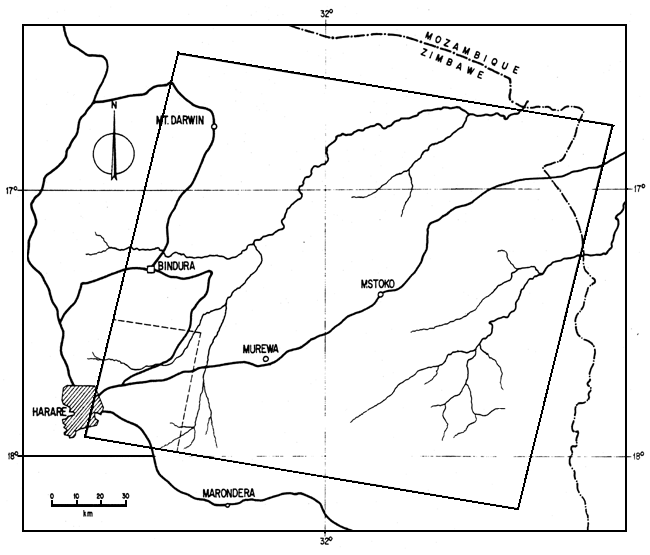
Figure 1. Area coverage in NE Zimbabwe of the 15 April 1985 Landsat Thematic Mapper image on Path 169 Row 072. The smaller area shown by dotted lines in the vicinity of Harare is the approximate area shown in Figures 4a and 4b.
A complete inventory of the water bodies on the rainy season image was made. Using the rainy season colour composite water bodies were identified and circled on a mylar overlay and cloud shadows were coloured out. Criteria for identification were drainage context, shape, character of the surrounding area and colour. A magnifying glass was used to verify many of the small water bodies.
The mylar overlay was transferred to the black and white (band 5) image and water bodies not visible on the colour composite were located and circled.
Also using the rainy season image as the base map, obvious land forms and land uses were delineated on another mylar overlay. The surface areas of each land use type or landform were estimated with a planimeter. Finally, the water bodies in each landuse-landform category were tabulated.
In order to estimate surface areas and changes in surface areas, the rainy season image was systematically sub-sampled within each landuse-landform stratum at about 5 percent. The same impoundments were located on the dry season image and the change in surface area was calculated. Surface areas were estimated using a dot grid overlay. Each dot represented an area of 4.44 ha. No attempt was made to estimate partial dots. Thus, surface area estimates in sequence, rounded to the nearest hectare, are 4, 9, 13, 18, etc. In this same sample the hue of each water body was noted to provide an indication of turbidity, which in turn, may suggest levels of aquatic productivity. Inferences about turbidity based on hue of water are that as particle size increases there is a colour shift from blue to green to yellowish green irrespective of wavelength until the colour of the water becomes that of the natural colour of the particles causing the turbidity (Salomonson, et al., 1983). The hue also can be influenced by life forms, and the spectral response of the predominant life form will determine the water colour. However, in shallow waters, such as ponds, the bottom can be detected and water colour would thus be altered towards bottom colour (Salmonson et al., op cit.)
 | |
| 2a | 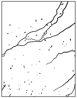 2b |
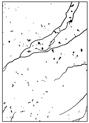
Figure 2a and 2b. Tracings of water bodies on the rainy season (2a) and dry season (2b) images NE of Harare. The elongated rectangle in the lower left corner is the runway at Harare airport. From the end of the rainy season to the end of the dry season many water bodies disappear and others are reduced in surface.
The preliminary results from the surface area estimates indicated that more than 40 percent of the water bodies fell into the smallest size category: 4 ha. For the expansion of aquaculture and fisheries, each small water body represents a separate opportunity for management and development. Accordingly, it was decided to make a second, more comprehensive sample of the water bodies of the smallest size. The locations of 51, systematically sampled at a rate of about 10 percent in each stratum, were noted on the 15 April (rainy season) image and their presence or absence was established on the 2 August (dry season) image.
The results are presented in two parts. The first is the outcome of the inventory, and the second is the changes in the water bodies surface areas over time.
In total, 906 water bodies were identified on the rainy season image. Eighty-two percent of the water bodies were associated with intensive agriculture, 13 percent with rangelands also including some croplands, and the remainder with higher, rougher terrain (Table 1).
Table 1
Water bodies identified on 1:250 000 Landsat Mapper overpass of NE Zimbabwe on 15 April 1985
| Land Use/Landform and Stratum | Area (km2) | No. of Water Bodies | Water Bodies per 100 km2 |
| Intensive Agriculture | |||
| 1 | 334 | 31 | 9 |
| 2 | 1 862 | 71 | 4 |
| 3 | 506 | 100 | 20 |
| 4 | 448 | 42 | 9 |
| 5 | 897 | 79 | 9 |
| 6 | 9 500 | 431 | 5 |
| 13 547 | 754 | mean = 9.3 | |
| Range Lands - Agriculture | |||
| 1 | 6 377 | 55 | 0.9 |
| 2 | 72 | 1 | 1.4 |
| 3 | 2 568 | 0 | 0 |
| 4 | 3 073 | 63 | 2.1 |
| 12 090 | 119 | mean = 1.1 | |
| Rugged Highlands | |||
| 1 | 6 763 | 43 | 0.6 |
| Totals | 32 400 | 916 | |
Stratification by land use or land form was fairly efficient in accounting for the density of water bodies. On agricultural lands, water body densities averaged 9.3/100 km2 and on rangelands 1.1/100 km2.
In total, the surface areas of 43 water bodies were estimated on the 15 April and 2 August images. Figure 2 is a tracing of water bodies on the rainy season and dry season images in the same area northeast of Harare.
Based on rainfall data for the 1983/84 to 1985/86 rainy seasons (Fig. 3), it can be inferred that most water bodies were full or nearly so when the 15 April 1985 imagery was acquired. The satellite overpass coincided with the end of the rainy season, and it was preceded by a cumulative rainfall of more than 1 000 mm. In contrast, the 2 August 1984 image coincided with the end of the the previous dry season which was itself preceded by a rainy season of less than 600 mm total rainfall. Thus, the 2 August imagery can be taken to represent the minimum water surface remaining at the end of the dry season.
The size-frequency distribution of 43 water bodies sampled from the 15 April 1985 (end of rainy season) imagery is shown in Figure 4. Most of the water bodies (42 percent) are in the 4 ha size interval and an additional 23 percent are in the 9 ha size interval. The frequency-weighted average size was 11 ha. The largest water body sub-sampled was in the 53 ha size interval. The cumulative surface area sub-sampled on the this image was 475 ha.
Based on the frequency-weighted average size, 11 ha, the estimate of the total surface area in the image is about 10 000 ha (916 water bodies (Table 1) × 11 ha/water body).
Of the 43 water bodies for which surface area was estimated on the rainy season image, only 32 (74 percent) could be found on the 2 August 1984 image. The total surface area of these 32 water bodies was 244 ha. The apparent overall decrease in surface area was 49 percent (475-244)/475.
Of the 51 smallest water bodies sampled from the wet season image (separate from those above), only 15 (29 percent) were found on the dry season image (Table 2).
In practice, only the colour of the larger water bodies, those in the third size class and larger (Fig. 3), 13 ha, could be discerned with visual methods. Of the 14 water bodies in this category, half were black indicating a minimum of turbidity or productivity, 4 were dark grey suggesting some small quantity of turbidity, one was grey, one was green perhaps indicating relatively high organic turbidity (i.e., phytoplankton), and another was light blue suggesting relatively high levels of inorganic turbidity.
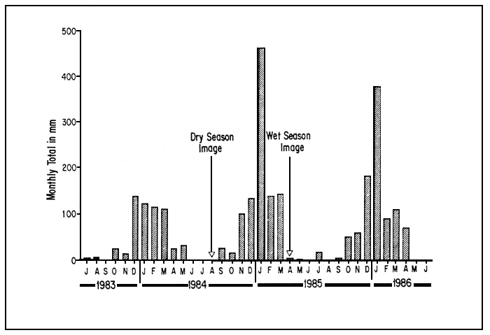
Figure 3. Time of image acquisitions in relation to total monthly rainfall at Harare from July 1983
to June 1986.
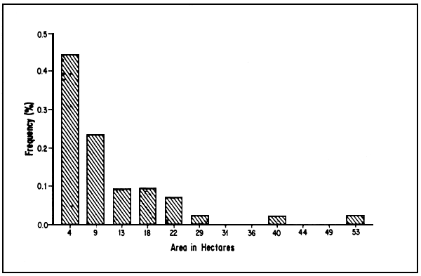
Figure 4. Surface area distribution of 43 impoundments on the rainy season image.
The results of this study indicate that satellite remote sensing can be a valuable tool to locate and inventory small water bodies for fishery and aquaculture development, if the advantages of the technology are fully utilized and its limitations are well understood.
Table 2
Changes in numbers of small water bodies identified on 1:250 000 Landsat Thematic Mapper images of NE Zimbabwe made on 15 April 1985 and 2 August 1984
| No. of SWB's Sampled | ||
| Land and Use/Landform and Stratum | End Rainy Season | End Dry Season |
| Intensive Agriculture | ||
| 1 | 2 | 0 |
| 2 | 6 | 0 |
| 3 | 9 | 2 |
| 4 | 2 | 2 |
| 5 | 5 | 3 |
| 6 | 20 | 7 |
| 44 | 14 | |
| Range Lands/some Agriculture | ||
| 1 | 4 | 1 |
| 2 | 0 | 0 |
| 3 | 0 | 0 |
| 4 | 1 | 0 |
| 5 | 1 | |
| Rugged Highlands | ||
| 1 | 2 | 0 |
| Totals | 51 | 15 |
Kenmuir (1981) used airphotos to determine SWB characteristics in the Arcturus I.C.A. area of Zimbabwe which also is within the area covered by the satellite images used in this study. His results generally are close to those reported herein:
| Satellite | Air Photos | |
| Number of SWB's in Sample | 43 | 77 |
| Total area est. | 485 | 673 |
| Mean area | 11 | 8.7 |
| Modal area | 4 | 1.6–2.5 |
| Area range | 4–53 | 0.8–45 |
There are several possible causes for differences between the satellite and airphoto results. Because of the scale of the satellite imagery, 1:250 000, it is likely that many of the smallest water bodies, those less than 1 ha, were not included in the inventory. However, airphotos usually are at a much larger scale, 1:20 000 to 1:40 000, and therefore, even the smallest water bodies can be detected. This accounts for the larger mean size of water bodies estimated in the present study than found by Kenmuir. Another cause for difference is the season during which the airphotos were acquired (not mentioned by the author). Rainy season imagery would provide larger area estimates than dry season imagery because water bodies would be bank-full. Furthermore, the satellite-derived estimates are from samples taken over a relatively large area, whereas the airphoto estimates are from a much lesser area. Finally, with the satellite images there is a possibility for misidentification. For example, shallowly flooded fields and newly ploughed moist soil are very similar to small water bodies on the satellite images.
As a follow-up to the present study, ground verification, an essential part of any study based on remote sensing, is required to obtain a better estimate of the reliability of the results.
Colour composities of bands 1, 3 and 4 were used in this study and gave satisfactory results for water body identification when used in conjunction with band 5; however, other combinations of Landsat TM bands have also been shown to be useful for inventory of water bodies. Composites of bands 2, 3 and 4 and of bands 3, 4 and 5 were used to identify water bodies by Trolier and Philipson (1986), and bands 4 through 7 were also used successfully singly, whereas water body identification was only marginal using bands 1, 2 and 3 singly.
An advantage of visual processing is that it is much more accessible than computer automated processing because sophisticated equipment is not required. Good results have been obtained by visual analysis of Thematic Mapper images for inventory of hydrologic land use including water bodies and wetlands (Trolier and Philipson, 1986). However, because only visual analyses were employed in the present study, the full range and benefit of the remote sensing technology was not realized. Computer processing of the imagery in contrast to visual analysis provides for more efficient use of time and for more comprehensive analyses. For example, with computer image processing, the computer could have been “trained” to locate and inventory SWB's automatically. One advantage of such automated processing is that the surface areas of each impoundment are individually estimated and the surface area and location stored for later analysis. Further, and even more important for the purposes of this particular inventory, computer processing provides for the detection of water bodies much smaller than those detected visually in this study. In theory, the Landsat Thematic Mapper with its 30 m instantaneous field of view would be able to detect water bodies of about 0.1 ha in extent. In practice, because the various kinds of materials surrounding the water body are also included in some of the picture elements, the resolution would be less. A rule of thumb is that to reliably detect a water body, its dimensions should be twice as large as the dimensions of the picture element (Salomonson et al., 1983). Thus, for the Thematic Mapper, a water body of about 0.4 ha could be detected. In contrast, with the visual dot-grid area estimation process used in the present study at 1:250 000 scale, water bodies of about 2 ha size and larger could be detected.
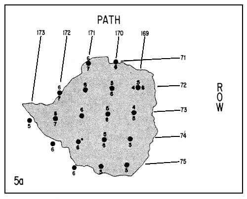
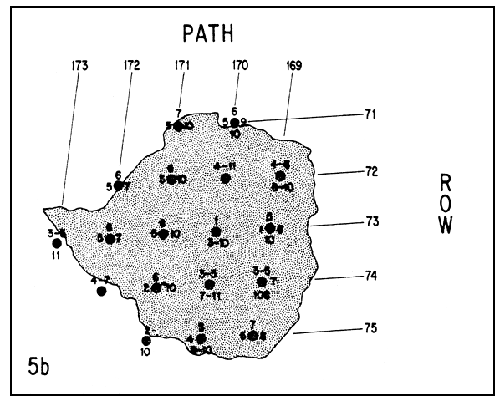
Figures 5a and 5b. Availability of recent Landsat Thematic Mapper (5a) and Multispectral Scanner (5b) data for Zimbabwe. Each back dot is the centre point of an image which is referenced by row and path. The numbers around the circles show the months during which good quality imagery with 10% or less cloud is available from 1984 through mid-1986. For example, for P169 R72. TM images are available for April, May and August, and MSS images are available for April to June and August to October. For the MSS data usually there are a number of months with repeat coverage. For example, for P170 R74 there are two MSS images for March and two for April.
Important questions when considering remote sensing applications in fisheries and aquaculture are the technical and financial feasibility of the enterprise, when compared to more traditional methods.
For Landsat satellite coverage of Zimbabwe 10 full images cover most of the country; twelve additional images, covering mainly border areas, would be required for complete coverage of the country (Fig. 5).
On the financial side, for computer compatible tapes, the cost is US$ 3 300 per Landsat Thematic Mapper image. For photograph-like products such as those used in this study, the cost is US$ 500 per image for colour-composites and US$ 250 for black and white at 1:250 000 scale. Thus, for Thematic Mapper coverage of most of the country, the cost would be US$ 33 000 for computer tapes and US$ 7 500 for photo-like products for visual processing. However, based on the results obtained in this study it seems that complete coverage of the country would not be required. For example, stratification by land use and land form suggests that if land use type is known, then total water body surface area can be estimated for a given part of the country. Such estimates can be made more precise and more use-specific by relating the sizes and densities of SWB's to each kind of agriculture more closely than has been possible in this study. Then, agriculture statistics on locations and expanses of various kinds of agriculture could be used as raising factors for SWB estimation. Rainfall and evaporation rates for various small parts of the country could be related to changes in satellite-derived surface areas of SWB's. These estimates could then be extrapolated over larger areas to estimate loss of surface area during the dry season.
Another cost-saving alternative, discussed from a technical viewpoint below, is to substitute Landsat Multi-Spectral Scanner (MSS) data for Thematic Mapper data wherever possible. The cost for Landsat MSS photographic products at 1:250 000 scale is US$ 150 less per image than TM, and the black and whites are US$ 100 less. For computer compatible tapes the cost differences are even greater, with a MSS tape for one image US$ 660 versus US$ 3 300 for a TM tape. Should aerial photographs be available from studies made by other branches of government, they could be used to supplement satellite information, and perhaps as a substitute for Landsat TM, if recent and if acquired during the months of interest to the small water body study.
The alternative to acquiring the information by remote sensing (satellite, or airborne photograph) is by ground surveys. Costs for ground coverage, even if on a small sample basis, are likely to be high partly because of the amounts of personnel time involved (e.g., time for interviews of farmers, for surface area surveys), but also because of the need for travel with attendant daily subsistence allowances and fuel costs. A fast-working ground survey team might cover a number of SWB's in a 100 km2 area in a day, but about a year would be required to equal the data acquired from a single Landsat image covering about 32 000 km2. The best approach, from a financial viewpoint, is to use the ground survey team for limited-time, specific investigations which verify the satellite observations and at the same time collect other complementary information, while using the satellite for wide-area spatial and temporal coverage.
From the technical point of view the principal concerns are the availability and quality of satellite images. Fortunately for Zimbabwe, there is good quality Landsat TM satellite coverage for the entire country with most scenes having 10 percent clouds, or no cloud cover at all (Fig. 5a). There is more than one TM image available for most of the country with the data acquired mostly in May, June and July in 1984, 1985 and 1986.
Landsat Multispectral Scanner data (MSS) are more numerous for the same years and the range of months is wider, from January through to October (Fig. 5b). Disadvantages of MSS relative to TM are that instantaneous field of view is less, 79 m vs. 30 m, and the spectrum is less, 4 bands for MSS versus 7 for TM. However, for the inventory of small water bodies the MSS would be adequate in most cases. MSS could probably detect SWB's of about 1 ha and larger as was the experience of Steffenson et al. (1981), and the land use and land form context could be as easily determined as with the TM. An approach suitable for the Zimbabwe study would be the use of MSS data for visual analysis of most of the country (on a sampling basis), and computer analysis of TM data for subsampling in order to inventory and classify the smallest water bodies as well as to estimate aquatic productivity of both large and small water bodies.
Another earth resources observation satellite, SPOT, was launched in 1986. The area covered by each image is only about one-tenth that of Landsat, but the resolution is better, 10 m for panchromatic and 20 m for the three bands available. SPOT data could be an alternative to Landsat TM for small area coverage for subsampling of water; however, a disadvantage is that it is much more costly per square kilometre of coverage than Landsat TM, and because it is new, there will be less historical imagery available for seasonal comparisons.
Also on the technical side, it is apparent that no costly equipment is required for visual processing. For automated processing, personal computer hardware and software packages for image processing are now available at relatively low cost, say, about US$ 55 000. The software and hardware have been designed to be easy to learn and to use. A disadvantage is that processing is slow relative to larger computers.
Low-cost, personal computer-driven image processing equipment has many possible uses, especially in agriculture, forestry and hydrology. Therefore, a workable approach to acquire the necessary equipment could be a shared-time, shared-cost basis with a sister branch of government (e.g., irrigation department). An additional advantage of such an arrangement is that much of the information of use in agriculture planning is also of use in aquaculture and fishery planning. Thus, not only are costs and equipment shared, but also data and imagery. Finally, software packages designed for the same equipment which is used for image processing can also be acquired to electronically merge existing map and tabular information with the satellite images. Such merging makes visualization of resources on maps and extraction of basic data more rapid than with manual techniques. Hardware-software combinations which perform this function are called Geographic Information Systems and they have found many applications in planning for resource development and management.
A visual analysis of landsat TM imagery acquired in the rainy reason in NE Zimbabwe showed 916 SWB's in an area of about 32 400 km2. The size of SWB's was estimated in 12 intervals from 4 to 53 ha. The smaller water bodies were most numerous. The total rainy season water body surface area within the satellite image was about 10 000 ha. The highest density of SWB's was associated with intensive agriculture, 9.3 SWB's/100 km2; there was a much lower density in rangelands, 1.1 SWB's/100 km2, and the least density was in high, rugged areas, 0.6 SWB's/100 km2. Comparison with dry season imagery indicates that there is an overall loss of water surface area amounting to 49 percent. The water surface loss is greatest among the smaller, more numerous water bodies with only 29 percent retaining some water through the end of the 1984 dry season. Water colours could be discerned only on larger water bodies. Colours discernible among water bodies suggested a wide range of organic and inorganic turbidity which would affect aquatic production.
Because of the comprehensive coverage of the country and good quality of the imagery, satellite remote sensing of small water bodies in Zimbabwe is technically feasible. Visual analyses would be considerably less costly than computer processing, but at the same time would limit the scope and utility of the results. A combination of Landsat Multispectral Scanner and Thematic Mapper data would satisfy technical requirements and also would be cost-effective. Should they be available from other studies, aerial photographs or SPOT satellite data could be used to supplement data acquired from LANDSAT.
From a financial point of view, satellite remote sensing is likely to be much more cost-effective and more rapid than ground surveys for providing comprehensive information about Zimbabwe's small water bodies for aquaculture and fisheries development. However, ground verification of satellite results would still be necessary, and at the same time ground surveys could be used to collect complementary information. The time and costs for these would be relatively small.
Balarin, J.D., 1984. National reviews for aquaculture development in Africa. 1. Zimbabwe. FAO Fish.Circ., (770.1):69 p.
Butera, M.K., 1982. Identification of water bodies using remotely sensed multispectiral scanner data with applications for inventory, hydrologic assessment, and habitat evaluation. NASA Tech.Memo., (NASA TM-84672):18 p.
FAO, (in press). Yearbook of fishery statistics. Annuaire statistique des pêches. Anuario estadístico de pesca, 1985. Catches and landings. Captures et quantités débarquées. Capturas y desembarques. Yearb.Fish.Stat./Annu.Stat.Pêches/Anu.Estad.Pesca, 60:462 p.
Kenmuir, D.H.S., 1981. Fish production and farm dams. Zimbabwe Agric. J., 78(6):209–14
Salomonson, V.V., et al., 1983. Water resources assessment. Chapter 29, In Manual of remote sensing. Vol. 2. Interpretation and applications. Falls Church, Virginia, American Society of Photogrammetry, The Sheridan Press, pp. 1497–570
Steffenson, R. et al., 1981. A procedure to overlay thematic map and dominion land survey system data to geometrically-corrected Landsat images and its application to agricultural land use studies in Western Canada. Paper presented at the Seventh Canadian Symposium on Remote Sensing. Winnipeg, Manitoba, 8–11 September 1981
Trolier, L.J. and W.R. Philipson, 1986. Visual analysis of Landsat Thematic Mapper images for hydrological land use and cover. Photogramm.Eng.Remote Sensing, 52(9):1531–8
![]()