![]()
![]()
![]()
The countries of southern Africa constitute much of the so-called “high Africa” and most of their territory lies above 1 000 m above sea level (Figure 1). The coastal plain is relatively narrow, except in northern Mozambique and Tanzania. Much of the interior consists of a large basin, filled with sedimentary rocks or Kalahari sands, which is bounded by mountain ranges along both the east and the west coasts. The eastern escarpment is dissected by a number of rivers, including the Zambezi, which is the largest in the region. The west coast is more arid, and the rivers draining into it tend to be smaller and highly seasonal.
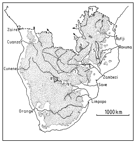
Figure 1. Topography and major drainage basins of southern Africa
The Rift Valley penetrates the region through Tanzania and into Malawi and includes two great lakes (Tanganyika and Malawi). Other lakes in the region include Lakes Victoria, Mweru and Bangweulu, and there are many smaller lakes. Most of these natural lakes are in the northeastern part of the region and there are none south of the Zambezi River.
Temperatures in the region are obviously greatest in the north, decreasing to the south, but they are also greatly modified by the altitude. Table 1 shows the trend towards lower temperatures at higher latitudes and the effect of altitude on the mean and extreme minimum temperatures. In addition to being generally cooler, extremes of cold become more marked at higher altitudes, especially towards the south. In most of the region, with the exception of Tanzania and the coastal plain of Mozambique, there is a wide variation between maximum and minimum temperatures. In most areas the differences between the highest monthly maximum and minimum temperatures exceed 20°C, rising to 30°C over the Kalahari and the interior of South Africa. This is in marked contrast to equatorial Africa and the humid regions of west Africa, where temperature variations are relatively small (Figure 2).
Table 1. Variations in temperature at selected stations in southern Africa
| Latitude | Altitude m.a.s.I | Mean | Extreme min. | ||
|---|---|---|---|---|---|
| Max. | Min. | ||||
| Mombassa, Kenya | 04° 02'S | 55 | 30°C | 23°C | 14°C |
| Tabora, Tanzania | 05° 02'S | 1 265 | 29°C | 17°C | 10°C |
| Mossuril, Mozambique | 14° 57'S | 15 | 31°C | 21°C | 12°C |
| Lusaka, Zambia | 15° 25'S | 1 274 | 26°C | 15°C | 4°C |
| Maputo, Mozambique | 25° 58'S | 64 | 28°C | 18°C | 7°C |
| Germiston, South Africa | 26° 15'S | 1 665 | 22°C | 10°C | -7°C |
(Data from Griffiths, 1972)
Table 2. Variation in annual rainfall (mm) at some stations in southern Africa
| Station | Climate | Maximum | Mean | Minimum |
|---|---|---|---|---|
| Swakopmund, Namibia | Hyper-arid | 29 | 10 | 0 |
| Tsabong, Botswana | Arid | 507 | 271 | 133 |
| Bulawayo, Zimbabwe | Semi-arid | 1 093 | 589 | 199 |
| Harare, Zimbabwe | Semi-humid | 1 291 | 868 | 550 |
| Karonga, Malawi | Humid | 1 826 | 1 081 | 649 |
(Data from Griffiths, 1972)
Much of the region is arid or semi-arid, and only a relatively small proportion of it can be described as “humid”, i.e., with an average rainfall of more than 1 000 mm/yr (Figure 3). Droughts are prevalent throughout and have affected most southern African countries during the last decade. Rainfall is strongly seasonal and highly variable throughout the region, as can be seen from Figure 4, where there is a gradient of variability and total rainfall from the humid areas in the north to the arid and semi-arid areas in the south, and this variability becomes more pronounced with increasing aridity (Table 2). As a rule, rain falls in the summer months from November to March, but on some parts of the South African coast rain falls throughout the year and there is a small winter rainfall area at the Cape of Good Hope.
This climatic pattern means that most rivers are seasonal and that their flow rates vary from year to year, typified by the flow pattern shown in Figure 5, which charts the mean and maximum flow of a small stream for the 25-year period 1954/55 to 1979/80. The lowest recorded - no measurable flow in any month - was in 1973/74.
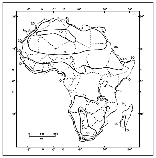
Figure 2. Differences between highest mean monthly maximum and lowest mean monthly minimum temperatures in Africa
(From Griffiths, 1972)
Table 3. The rate of large reservoir construction in South Africa
| Decade | Number of dams | Capacity (× 106 m3) |
|---|---|---|
| 1880 | 2 | 144 |
| 1890 | 4 | 7 |
| 1900 | 12 | 22 |
| 1910 | 19 | 232 |
| 1920 | 41 | 984 |
| 1930 | 34 | 3 049 |
| 1940 | 29 | 291 |
| 1950 | 91 | 1 174 |
| 1960 | 109 | 3 803 |
| 1970 | 68 | 14 128 |
| 1980 | 4 | 283 |
| 413 | 24 117 |
(From Braune, 1985)
Table 4. Construction of small dams in a farming area in South Africa
| Year | No. of dams in catchment of 370 km2 | Capacity as % of mean annual runoff |
|---|---|---|
| 1976 | 200 | 3% |
| 1984 | 400 | 10% |
(From Braune, 1985)
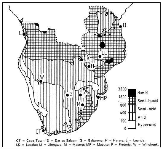
Figure 3. The average rainfall over southern Africa and the major climatic divisions of the region.
(Redrawn and adapted from Thompson, 1965)
In order to counteract this unpredictability and to ensure year-round supplies of water, numerous reservoirs have been built in most countries of the region. These range from enormous man-made lakes like Kariba (>5 000 km2) and Cahora Bassa (>2 000 km2) on the Zambezi River, to small ponds. In some countries, these reservoirs are now very numerous. In Zimbabwe, for example, the number of large dams (i.e., with a capacity exceeding 106 m3) has grown exponentially, and there are now about 140 of them in the country (Figure 6), plus 10 747 smaller ones according to the most recent estimates (Chimowa and Nugent, undated). Most major dam sites will eventually be utilized and relatively few large dams will remain to be built. South Africa appears to be reaching this situation. The country is largely semi-arid to arid and, as it is relatively industrialized, the demand for water is very high. Consequently, most of its potential large dam sites have been utilized and the rate of large dam construction has decreased (Table 3) although the number of small dams continues to increase (Table 4).
Fish production is lower in Africa than in any other continent (Table 5). In southern Africa the production of fish per caput is relatively low, but varies widely from country to country. Data available in Van den Bossche and Bernacsek (1990), although now outdated, give a good general impression of the relative availability of fish in each country, excepting South Africa (Table 6). Those countries with marine resources naturally have the greatest supply of fish, although the inland capture fisheries of Tanzania produce more than its marine fisheries. This is primarily because of the resources available to it in Lakes Tanganyika and Victoria. Of the landlocked countries, Zambia and Malawi have extensive lakes or floodplains and the availability of fish is consequently much higher than it is in Botswana, which is arid, or Lesotho and Swaziland, which have small streams or limited water resources. Most of Zimbabwe's fish production comes from lake Kariba; without this water body the supply of fish would be very low indeed. Namibia and South Africa are both largely arid or semi-arid and have insignificant inland fisheries.
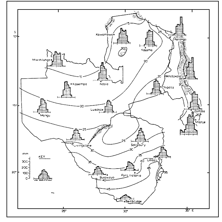
Figure 4. The coefficient of variability of annual rainfall (%) and seasonal distribution of rainfall in Malawi, Zambia and Zimbabwe
(From Torrance, 1972)
The availability of fresh fish in the region is likely to change. Economic reform programmes are easing restrictions on its importation and movement from country to country; the availability of cheap marine fish from Namibia is likely to have a particularly severe impact on production from inland waters. Nevertheless, the need to increase fish production in the region remains because of a general decrease in production from the sea and from large inland waters like Lake Tanganyika. In southern Africa, most fisheries development has been directed towards the largest inland water bodies (Lakes Tanganyika, Malawi and Kariba) or to attempts to develop integrated aquaculture systems of various kinds. Smaller water bodies have largely been neglected, although they probably represent the best hope for progress in the near term.
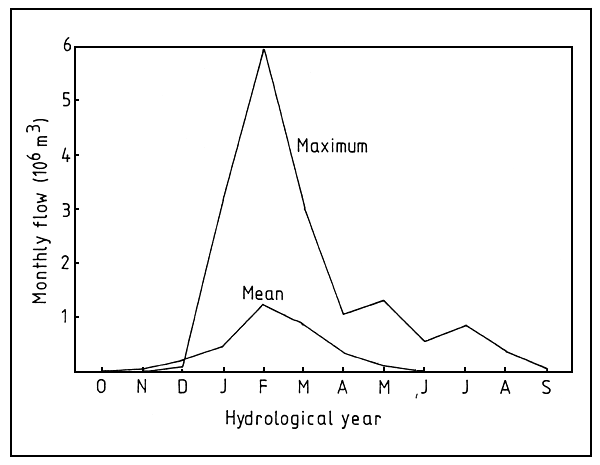
Figure 5. Flow pattern in the Mukuvisi River, a small stream near Harare, Zimbabwe, with a catchment area of 20 km2
(Data from Anon., 1980)
Table 5. Average catches of marine and freshwater fish, populations (1990) and catch per caput in various parts of the world
| Fish catch (× 103 t) | Population (× 106) | Catch/head (kg) | |
|---|---|---|---|
| Africa | 4 695.5 | 647.5 | 7.3 |
| N. & C. America | 8 582.2 | 427.2 | 20.1 |
| S. America | 12 615.3 | 296.8 | 42.5 |
| Asia | 40 029.0 | 3 108.5 | 12.8 |
| Europe | 12 747.2 | 497.7 | 25.6 |
| Former USSR | 10 980.8 | 288.0 | 38.1 |
| Oceania | 693.4 | 26.5 | 26.2 |
The FAO Aquaculture for Local Community Development (ALCOM) Programme, based in Harare, has therefore included a project on “Utilization of Small Water Bodies for Aquaculture and Fisheries” (Project GCP/RAF/277/BEL, funded by Belgium). Activities began on a small scale in 1989, and included appraisal of the potential of small water bodies, methods to enhance their production, ways to involve local communities and to control waterborne diseases. ALCOM sponsored a Technical Consultation on Small Water Bodies in 1992, which reviewed what was known about these fisheries in the region (Haight, 1993). This paper summarizes this knowledge and includes further information gathered since that consultation. It should be noted that unattributed statements about small waters and their fisheries in southern Africa are generally based on currently unpublished data from ALCOM.
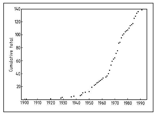
Figure 6. Number of large (> 106 m3) dams in Zimbabwe, 1910–1990
(Data from Ministry of Water Resources and Development, Harare)
Table 6. Approximate fish catch from inland and marine fisheries in the SADC countries (1987) and the nominal supply/head
| Inland capture (t) | Marine capture (t) | Total(1) (t) | Nominal supply (kg/head) | |
|---|---|---|---|---|
| Angola | 8 000 | 73 339 | 81 339 | 8.8 |
| Botswana | 1 900 | 1 900 | 1.6 | |
| Lesotho | 26 | 26 | 0.02 | |
| Malawi | 88 485 | 88 588 | 11.9 | |
| Mozambique | 246 | 35 850 | 36 117 | 2.4 |
| Namibia | 150 | 519 368 | 519 578 | 316.2(2) |
| Swaziland | 44 | 63 | 0.09 | |
| South Africa | 2 300 | 534 100 | 536 400 | 15.2 |
| Tanzania | 265 735 | 44 775 | 313 545 | 12.9 |
| Zambia | 66 980 | 68 000 | 9.5 | |
| Zimbabwe | 17 344 | 17 500 | 1.8 |
Note 1. The total includes estimated aquaculture production, which is not listed separately.
Note 2. This value includes the catch from vessels flying the South African flag. Most of that catch
is reduced to fish meal for export; the actual amount available to the population is unknown.
Based on data in Vanden Bossche and Bernacsek, 1990; FAO, 1990)
![]()
![]()
![]()