![]()
![]()
![]()
by
Mahmoud Mohammed Rashid
Head, Regional Planning Project
Aswan, Egypt
| ABSTRACT |
| The Aswan High Dam Lake consists of Lake Nasser in Egypt and Lake Nubia in Sudan. Storage of water in the High Dam Lake started in 1964. Its main purposes were power generation and storage of water for irrigation. The annual share of Egypt at the maximum water level (180 masl) will be 55 000 million m3, that of Sudan 18 000 million m3. The annual discharge rate is 84 000 million m3. More than 70% of the sediment carried into the lake by the River Nile is deposited near Wadi Halfa in Lake Nubia. |
| Seasonal fluctuations of a number of physico-chemical parameters are presented, while phytoplankton composition in 1988 is compared with that in 1976 and 1979. |
| Data on fish biology are given for the main commercial species in the lake. |
| Fish landings decreased from 34 000 t in 1981 to 15 700 t in 1989, but increased again to 21 900 t in 1990 and to 30 800 t in 1991. The main species is Tilapia, which forms 89% of the total landings. Approximately 92% of the catch is landed fresh. Salted fish production decreased from 57% of the total landings in the early years of impoundment to less than 10% in 1990. |
| In recent years, the income of fishermen has increased, mainly because of rapidly increasing fish prices: the net revenue in 1991 being LE 3 900. |

Figure 1 Map of High Dam Lake: Lake Nasser (Egypt) and Lake Nubia (Sudan)
Egypt's High Dam was constructed at Aswan in 1964 to maximize the net benefit from the Nile River by preserving its water the whole year round. The Aswan High Dam is also used for power generation. Installed hydro-electric capacity is about 2 100 MW and the annually generated power is 10 TWh.
The major part of the reservoir lies in the subtropics. The climate is extremely arid with almost no rainfall. The surrounding area is generally a desert and terrestrial life is largely restricted to a few metres along the edge of the lake. Such a situation is unique among the man-made lakes of Africa.
Large reservoirs are generally used for a limited number of purposes, which include generation of electricity; water storage for irrigation, industrial or domestic use; flood control; and regulation of flow for navigation (Lagler, 1969). Occasional attempts have been made to evaluate an expected increase in fish production, and to a lesser extent the potential earnings from increased tourism and recreation.
The High Dam differs from other dams in a number of characteristics. It is the biggest rockfill dam in the world. It has an impervious core, with a grout curtain that extends 180 m under the core to meet the rock, and a horizontal upstream impervious blanket. The length of the dam at the top is 3 600 m, while the width is 980 m at the bottom and 40 m at the top, and its height above the river bed level is 111 m.
The High Dam Lake is one of the largest man-made lakes in Africa and second in area after Lake Volta in Ghana. The reservoir extends from the High Dam at Aswan (Egypt) to Dal Cataract in the Sudan, i.e., between 23°58' and 20°27' N, and between 30°35' and 33°15'S (Figure 1).
Table 1 Morphometric features of Lake Nasser and Lake Nubia at the 160 m and 180 m levels
| Parameter | Lake Nasser | Lake Nubia | |||
| 160 m | 180 m | 160 m | 180 m | ||
| Length | (km) | 291.8 | 291.8 | 127.5 | 189.5 |
| Shoreline | (km) | 5380 | 7844 | 647 | 1406 |
| Surface area | (km2) | 2585 | 5238 | 472 | 978 |
| Volume | (km3) | 55.6 | 132.5 | 10.3 | 24.4 |
| Mean width | (km) | 8.9 | 18.0 | 3.7 | 5.2 |
| Mean depth | (m) | 20.6 | 24.8 | 20.1 | 25.9 |
(Sources: Entz, 1973, 1974)
The main morphometric characteristics of the reservoir are given in Table 1. The total length of the reservoir at 180 m level is about 481.3 km, the total shoreline 9 250 km, the surface area 6 216 km2, the volume 156.9 km3, the mean width 12.5 km, and depth 25.2 m (Entz, 1973, 1974; Latif, 1984).
The reservoir consists of two parts, Lake Nasser in Egypt and Lake Nubia in the Sudan. The southern two thirds of Lake Nubia are narrow, mainly due to the presence of the Gorge region, which is about 135 km long. The remaining part - from Amka to the High Dam - is much wider (Figure 1).
One of the main features of Lake Nasser is the presence of side extensions, lagoons, locally named khors. There are 48 khors on the eastern shore and 38 khors on the western shore of Lake Nasser (Figure 1). Lake Nubia also shows this ramified nature, but to a much lesser extent.
The High Dam Lake can be divided into three sections (Latif, 1984):
the riverine section, with all-year riverine characteristics, comprising the southern part of Lake Nubia from the southern end of the lake to Daweishat;
the semi-riverine section, with riverine characteristics during the flood season and lacustrine characteristics during the rest of the year, comprising the northern part of Lake Nubia and the southern part of Lake Nasser, extending from Daweishat to Amada/Tushka; and
the lacustrine section, extending from Amada/Tushka to the Aswan High Dam.
The storage of water in the reservoir started in May 1964. The total capacity of the reservoir is 157 000 million m3. The annual share of Egypt is 55 000 million m3 and that of Sudan is 18 000 million m3, out of an average annual discharge of 84 000 million m3.
Maximum and minimum water levels in the period 1980–1990 are given in Table 2. The annual minimum water level dropped from a maximum of 171 m in 1980 to a minimum of 151 m in 1988, after which it increased to 164.5 m. The lake's expected maximum level of 180 m, which was foreseen for 1980, has not yet been reached.
Table 2 Water levels (metres above sea level) in the period 1980 to 1990
| Year | Maximum | Minimum |
| 1980 | 176.22 | 171.18 |
| 1981 | 175.96 | 171.13 |
| 1982 | 172.63 | 170.18 |
| 1983 | 169.87 | 165.64 |
| 1984 | 164.65 | 162.97 |
| 1985 | 164.30 | 156.30 |
| 1986 | 163.50 | 157.40 |
| 1987 | 161.50 | 154.80 |
| 1988 | 168.75 | 151.03 |
| 1989 | 169.79 | 164.60 |
| 1990 | 169.45 | 164.43 |
The flood waters of the River Nile carry about 125 million tons of suspended matter (silt) per year. The bulk is present in the flood water which usually reaches Wadi Halfa in July every year. It is heavily loaded with inorganic clay, silt and sand, and organic debris (detritus).
Deposition in the reservoir is governed by a number of factors. The major factor is the sudden decrease of flow velocity of the Nile water as soon as it reaches the open area of Lake Nubia. Theoretically, the deposition should be greatest at the junction area, about 357 km from the High Dam, and gradually decrease further downstream.
To explain the rather complex pattern of deposition, a number of hydrological and morphological characteristics have to be taken into consideration:
the annual effective base level of deposition;
the level changes during the flood period; and
the effects of relief on deposition.
Since the closure of the High Dam in 1964, a large amount of alluvial sediment has been deposited in the southern part of the lake in Sudan, mainly between Akasha (km 481) and Wadi Halfa (km 345). The average sediment thicknesses are given in Table 3.
Table 3 The annual percentage of sediment deposited and average thickness of sediment layers at various localities in the High Dam Lake
| Locality | Distance upstream from the High Dam (km) | Proportion of sediment deposited (%) | Average sediment layer thickness (m) |
| Akasha | 481 | 1.56 | 1.5 |
| Melik El-Nasser | 448 | 7.96 | 4.0 |
| Kagnarti | 395 | 2.53 | 8.0 |
| Gemai-Amka | 375-365 | 5.37 | 17.0 |
| Abca (2nd Cat.) | 360 | 10.74 | 20.0 |
| Wadi Halfa-Sarra | 345-308 | 70.89 | 12.0 |
| Adindan | 305 | 0.32 | 2.0 |
| Abu Simbel | 280 | 0.63 | 1.0 |
When the flood water reaches the last section of the Gorge region, and especially the open water area of the lake 357 km upstream from the High Dam, near the Second Cataract, heavy sedimentation takes place.
This is mainly caused by the narrow inlet and the hard relief of the reservoir in the Gorge region that extends northwards from Akasha (km 481) to Amka (km 365), where the water is very turbid, with Secchi disc readings of less than 10 cm.
The reservoir, with its single inflow in the south and outflow in the north, can be considered as an extremely slow flowing, wide river, with riverine and semi-riverine sections. Shortly after its formation in 1964, the riverine and semi-riverine sections dominated, but gradually Lake Nasser showed more lacustrine characteristics.
In the riverine section all year round, and in the semi-riverine section during the flood season, the allochthonous, mainly inorganic components are the dominant elements of the syrton.
In the lacustrine section, the autochthonous suspended particles (seston) are dominant, with a high content of organic particles (detritus).
The syrton content decreased from south to north due to sedimentation of its different components (sand, silt and clay) (Entz, 1974).
The amount of autochthonous suspended matter is rather small (1–10 mg/l) compared with the amount of allochthonous silt, which can reach several hundreds or even 2 000 to 8 000 mg/l in the southern section of the lake, as well as in the inflowing Nile River.
Approximately 20% of the sediment carried annually by the River Nile is deposited in the Gorge region, another 10% between Amka and the Second Cataract, and the remaining 70% in the open areas of Lake Nubia near Wadi Halfa (Figure 2 and Table 3). The amount of deposited sediment at Adindan-Abu Simbel in the most southern part of Lake Nasser was estimated at less than 1%. This deposition will lead to a new inland delta formation of the Nile, which will gradually extend northwards. If the rate and character of the sedimentation does not change, it can be assumed that within 10 years some mud banks will appear in Lake Nubia between the Second Cataract and Wadi Halfa, and at the same time a thin layer of the fertile mud will be deposited in the former river bed at Abu Simbel.
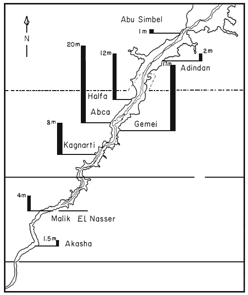
Figure 2 Sediment thicknesses at some localities in High Dam Lake
Water temperature profiles of the uppermost 15 m water layer are given in Figures 3-A and 3-B for a number of stations in Lake Nasser and some khors of Lake Nasser, for August and November 1976 and February and May 1977.
The depth profiles clearly reveal stratified conditions in Lake Nasser and in the khors in August 1976 and May 1977 and more uniform temperature distributions in November 1976 and February 1976. Lake Nasser is warm monomictic with a single circulation period during winter between November and March (Entz, 1976).
For some stations of Lake Nubia, water temperatures in the uppermost 15 m water layer in August 1976 are given in Table 4. In the riverine section of Lake Nubia stratified conditions did not occur in August 1976 due to the mixing effects of the flood water.
Table 4 Water temperature (°C) at some stations of Lake Nubia in August 1976
| Depth | Station | |||
| Sarra km 310 | Wadi Halfa km 352 | Dewashate km 415 | Akasha km 480 | |
| 0 | 28.0 | 28.0 | 29.0 | 28.0 |
| 1 | 28.0 | 28.0 | 28.0 | 27.0 |
| 2 | 28.0 | 28.0 | 28.0 | 27.0 |
| 3 | 28.0 | 28.0 | 28.0 | 27.0 |
| 4 | 27.0 | 28.0 | 28.0 | 27.0 |
| 5 | 27.0 | 28.0 | 28.0 | 27.0 |
| 10 | 27.0 | 27.0 | 28.0 | 27.0 |
| 15 | 27.0 | 27.0 | 27.0 | |
| Bottom | 20.0 (50 m) | 21.0 (30 m) | ||
In the High Dam Lake, turbidity is mainly influenced by:
allochthonous inorganic sand-silt-clay of riverine origin, and
autochthonous suspended organic material, plankton and detritus.
Secchi disc transparency measurements revealed differences in turbidity between the three sections of the reservoir (Figure 4). During the flood season (August–October) the inorganic turbidity is very high in the riverine and semi-riverine sections of the lake. Transparency is reduced to 15-8 cm at Melik El-Nasser and to 7 cm at Daweishat and Akasha. At the southern end of Lake Nasser, near Adindan, transparency varies between 50 and 100 cm. In the northern part of Lake Nasser transparency is usually higher because of the absence of silt and transparency may reach values between 300 and 400 cm.
Seasonal fluctuations in turbidity were also observed in Lake Nasser. Near the High Dam, autochthonous organic turbidity caused by phytoplankton blooms, of the blue-green algae especially, reduces the Secchi disc transparency to less than 50–100 cm in spring and early summer. In autumn and winter, the phytoplankton density diminishes and the transparency gradually increases.
The transparency in the khors is normally slightly less than in adjacent open water areas due to abundant suspended organic material. The khors of the southern section are highly affected by the turbid flood water, especially those with a wide entrance.
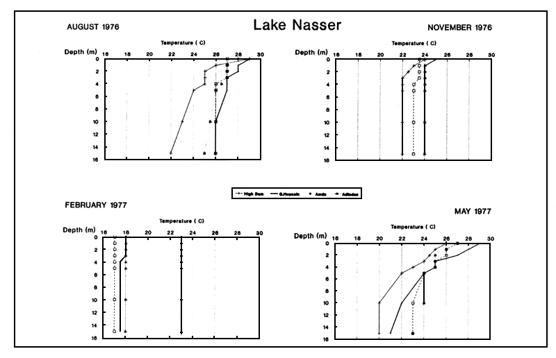
Figure 3-A Temperature depth profiles for four stations on Lake Nasser for August and November 1976 and February and May 1977
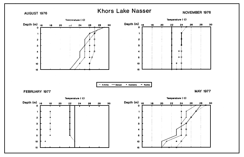
Figure 3-B Temperature depth profiles for four khors of Lake Nasser for August and November 1976 and February and May 1977
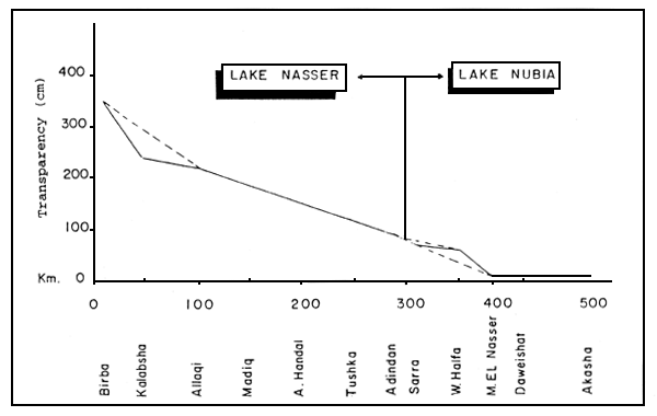
Figure 4 Secchi disk transparency (cm) at some stations on Lake Nasser and Lake Nubia in August
The highest values recorded by Latif (1984) for electrical conductivity (EC) in Lake Nasser were approximately 300 μmhos.cm-1 at the High Dam and Kalabsha in November 1970. The average EC values showed a decreasing trend southwards in the different seasons, except for the summer, when a reverse picture was generally seen.
The highest conductivity was measured just in front of the flood water (280–350 μmhos.cm-1) and the lowest EC was the end of the flood (160–200 μmhos.cm-1). Conductivity ranged between 199 and 224, 170 and 249, 230 and 255, and 185 and 240 μmhos.cm-1 in winter, spring, summer and autumn respectively (Figure 5).
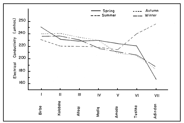
Figure 5 Electrical conductivity at some stations on Lake Nasser in different seasons
Dissolved oxygen (DO) depth profiles of the upper 15 m of the water column are given for a number of stations on Lake Nasser and some of its khors in Figure 6.
Seasonal changes in dissolved oxygen concentration closely reflect the main phases of thermal stratification in Lake Nasser (Latif, 1984). During the circulation period, Lake Nasser and the khors are well oxygenated from top to bottom and dissolved oxygen concentrations range between 10.3 and 6.2 mg/l. In March–April, the DO concentration generally decreases with depth in the lacustrine and semi-riverine sections of the lake. DO concentrations are high in the uppermost 10 m (usually above 8.5 mg/l) and very high concentrations (9.5–13.5 mg/l) may occur near the surface. In May–June the DO concentration can be fairly high (up to 14.2 mg/l) at the surface and as low as 2 mg/l near the bottom. The oxygen concentration always diminishes towards the bottom, and sometimes oxygen-free water is present at 15 m depth. A strong smell of H2S can be noted in water up to 2 m above the bottom. A stable stratification of the lake is evident and the position of the metalimnion varies between 9 and 25 m. In July–August, the DO concentration ranges between 9.5 and 0.0 mg/l in the upper 15 m in Lake Nasser. In Khors El Birba and Manan, near the High Dam, oxygen is then absent near the bottom. In October–November, stratification disappears, and in December the lake becomes saturated or nearly saturated with oxygen from the surface to the bottom.
For some stations on Lake Nubia, dissolved oxygen concentrations in the upper 15 m water layer in August 1976 are given in Table 5. The flood affects the stratification of the lake, but its effect is restricted to the southern part of the lake and its mixing effect is not complete. In the northern part of Lake Nubia, at Khor Sarra, oxygen can be absent near the bottom, but at the stations in the riverine section of the lake, between Murshid and Akasha, the dissolved oxygen concentration never reaches 9 mg/l and never drops below 7 mg/l (Table 5).
Table 5 Dissolved oxygen (mg/l) at some stations on Lake Nubia in August 1976
| Depth | Station | |||
| Sarra km 310 | Wadi Halfa km 352 | Dewashate km 415 | Akasha km 480 | |
| 0 | 6.7 | 8.3 | 7.6 | 7.3 |
| 1 | 6.6 | 8.2 | 7.6 | 7.4 |
| 2 | 6.5 | 8.2 | 7.6 | 7.3 |
| 3 | 6.3 | 8.2 | 7.8 | 7.4 |
| 4 | 6.3 | 7.7 | 7.7 | 7.3 |
| 5 | 6.0 | 7.5 | 7.8 | 7.4 |
| 10 | 5.7 | 6.7 | 7.8 | 7.4 |
| 15 | 5.6 | 6.5 | 7.7 | 7.4 |
| Bottom | 0.0 | 1.4 | ||
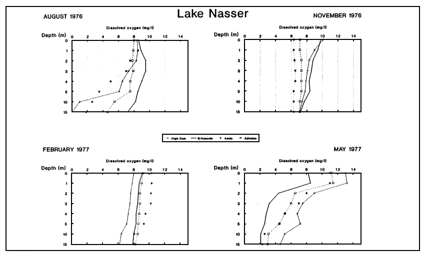
Figure 6-A Dissolved oxygen depth profiles for four stations on Lake Nasser for August and November 1976 and February and May 1977
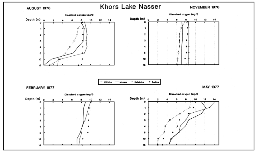
Figure 6-B Dissolved oxygen depth profiles for four khors of Lake Nasser for August and November 1976 and February and May 1977
Seasonal fluctuations in pH, carbonate and bicarbonate alkalinity are given for some stations on Lake Nasser, some khors of Lake Nasser, and for Lake Nubia in Table 6.
pH values ranged between 7.2 and 9.5 in the High Dam Lake, and decreased in general with depth, except for Akasha in Lake Nubia.
In the High Dam Lake, bicarbonate alkalinity is common in most of its water. HCO3- showed no major variations from surface to bottom, and ranged from 52 to 146 mg/l in the main channel of Lake Nasser. In Lake Nubia, concentrations were higher, and in the khors lower, than in the main channel. In general, higher values were observed in August and November than in February and May.
Carbonate showed a decreasing pattern from year to year and in recent years has not constituted more than 1% of the total alkalinity. In the High Dam Lake, hydroxide (OH-) alkalinity is rare. CO2 could be detected in the water layers below 30 m depth.
Table 6 pH, carbonate and bicarbonate alkalinity (mg/l) for some stations on Lakes Nasser and Nubia
| Parameter | pH | CO3 | HCO3 | pH | CO3 | HCO3 | pH | CO3 | HCO3 | pH | CO3 | HCO3 |
| A. LAKE NASSER | ||||||||||||
| Station (depth) | High Dam (70–88 m) | G. Hussein (45–60 m) | Amada (40–50 m) | Adindan (50–58 m) | ||||||||
| a. August 1976 | ||||||||||||
| Surface | 8.2 | 0.0 | 112 | 8.6 | 1.0 | 116 | 8.9 | 2.0 | 90 | 8.2 | 0.6 | 122 |
| Middle | 7.5 | 0.0 | 114 | 7.5 | 0.0 | 102 | 8.5 | 0.0 | 104 | 8.1 | 1.2 | |
| Bottom | 7.3 | 0.0 | 122 | 7.5 | 0.0 | 88 | 7.9 | 0.0 | 104 | 8.0 | 0.0 | 120 |
| b. November 1976 | ||||||||||||
| Surface | 8.2 | 0.6 | 146 | 8.1 | 0.0 | 134 | 8.4 | 6.0 | 116 | 8.4 | 2.0 | 114 |
| Middle | 7.8 | 0.0 | 134 | 7.8 | 0.0 | - | 8.0 | 0.0 | - | 7.9 | 0.0 | - |
| Bottom | 7.5 | 0.0 | 146 | 7.6 | 0.0 | 136 | 7.8 | 0.0 | 110 | 7.7 | 0.0 | 122 |
| c. February 1977 | ||||||||||||
| Surface | 9.0 | 0.0 | 80 | 8.8 | 0.4 | 76 | 8.7 | 0.0 | 68 | 8.25 | 0.0 | 58 |
| Middle | 9.0 | 0.0 | 68 | 8.7 | 0.0 | 64 | 8.4 | 0.0 | 64 | 8.2 | 0.0 | 58 |
| Bottom | 8.9 | 0.0 | 66 | 8.5 | 0.0 | 72 | 8.1 | 0.0 | 58 | 8.15 | 0.0 | 52 |
| d. May 1977 | ||||||||||||
| Surface | 8.6 | 0.6 | 60 | 8.7 | 0.8 | 64 | 8.9 | 0.4 | 62 | 8.9 | 0.6 | 60 |
| Middle | 8.1 | 0.0 | 70 | 8.1 | 0.0 | 76 | 8.6 | 0.0 | 68 | 8.1 | 0.0 | 66 |
| Bottom | 7.9 | 0.0 | 66 | 7.9 | 0.0 | 68 | 8.5 | 0.0 | 70 | 7.8 | 0.0 | 64 |
| B. SOME KHORS OF LAKE NASSER | ||||||||||||
| Station (depth) | El Birba (25 m) | Manam (27 m) | Kalabsha (30 m) | Tushka (19 m) | ||||||||
| a. August 1976 | ||||||||||||
| Surface | 8.3 | 0.6 | 100 | 8.5 | 0.2 | 94 | 8.5 | 0.0 | 94 | 9.2 | 1.0 | 90 |
| Middle | 7.7 | 0.0 | 100 | 7.4 | 0.0 | 106 | 7.5 | 0.0 | 112 | 9.2 | 0.0 | 100 |
| Bottom | 7.5 | 0.0 | 114 | 7.4 | 0.0 | 116 | 7.3 | 0.0 | 112 | 9.2 | 0.0 | 106 |
| b. November 1977 | ||||||||||||
| Surface | 8.6 | 0.6 | 106 | 8.7 | 0.2 | 116 | 8.2 | 0.0 | 126 | 8.5 | 2.0 | 106 |
| Middle | - | - | - | - | - | - | - | - | - | 8.5 | 0.0 | - |
| Bottom | 8.4 | 0.6 | 120 | 7.8 | 0.0 | 116 | 7.8 | 0.0 | 124 | 8.5 | 0.0 | 106 |
| c. February 1977 | ||||||||||||
| Surface | 9.2 | 0.0 | 68 | 8.6 | 0.0 | 76 | 8.7 | 0.0 | 70 | |||
| Middle | - | 0.0 | - | - | 0.0 | - | - | 0.0 | - | |||
| Bottom | 9.2 | 0.0 | 66 | 8.5 | 0.0 | 70 | 8.6 | 0.0 | 66 | |||
| d. May 1977 | ||||||||||||
| Surface | 8.6 | 0.6 | 62 | 8.5 | 0.6 | 60 | 8.2 | 0.8 | 60 | 8.8 | 0.6 | 66 |
| Middle | - | - | - | - | - | - | 7.8 | 0.0 | 64 | - | - | - |
| Bottom | 7.9 | 0.0 | 70 | 8.0 | 0.0 | 66 | 7.6 | 0.0 | 74 | 8.1 | 0.0 | 70 |
| C. LAKE NUBIA | ||||||||||||
| Station | Sarra | Wadi Halfa | Daweishat | Akasha | ||||||||
| August 1976 | ||||||||||||
| Surface | 9.5 | 1.0 | 110 | 8.7 | 0.8 | 100 | 8.1 | 0.0 | 120 | 8.2 | 0.0 | 110 |
| Middle | 8.5 | 0.0 | 124 | 8.0 | 0.0 | 102 | 7.8 | 0.0 | - | 9.1 | 0.0 | - |
| Bottom | 8.2 | 0.0 | 110 | 7.6 | 0.0 | 112 | 7.9 | 0.0 | 124 | 9.0 | 0.0 | 124 |
The nitrate concentration in the main channel of Lake Nasser and in the khors was higher in November than in August or May. In Lake Nubia, nitrate concentration was highest at Sarra, ranging from 1.0 mg/l at the surface to 1.2 mg/l at the bottom.
In general, the PO4 concentration was highest in November and lowest in February, increasing with depth. In Lake Nasser near the High Dam, higher concentrations of orthophosphate were observed in August and November, ranging between 0.5 and 0.1 mg/l. In the southern part of Lake Nubia, phosphate concentrations were higher than in the northern part, ranging from 0.37 to 0.5 mg/l.
Seasonal fluctuations in silicate concentration are given in Table 7 for Lake Nasser, the khors and Lake Nubia.
Table 7 Silicate concentrations for some stations on Lake Nasser and its khors, and on Lake Nubia
| Period | August | November | February | May |
| A. Main channel, Lake Nasser | ||||
| Surface | 17.5–35.0 | 12.5–17.0 | 14.0–18.5 | 10.0–15.0 |
| Middle | 15.0–18.8 | - | - | 11.3–17.5 |
| Bottom | 17.5–25.0 | 17.0–17.5 | 12.5–19.5 | 10.0–16.2 |
| B. Khors, Lake Nasser | ||||
| Surface | 12.5–30.0 | 12.5–20.0 | 12.7–17.2 | 11.3–16.3 |
| Bottom | 17.5–21.3 | 14.5–20.0 | 12.1–15.8 | 8.0–15.0 |
| Middle | 16.3–17.3 | - | - | - |
| C. Lake Nubia - August | ||||
| Sarra - Wadi Halfa | Daweishat - Akasha | |||
| Surface | 20.0–21.3 | 15.0–16.0 | ||
| Middle | 17.5–20.0 | - | ||
| Bottom | 18.0–20.0 | 9.5–18.0 | ||
Seasonal fluctuations in chloride and sulphate concentration in Lake Nasser and the khors are given in Tables 8 and 9. Cation concentrations were comparable with the values given by Latif (1984).
Table 8 Chloride concentrations in Lake Nasser and its khors
| Water layer | April | July | November | January |
| Surface | 7.1 – 9.88 | 6.69 – 9.50 | 5.4 – 7.6 | 3.46 – 9.40 |
| Bottom | 5.2 – 8.99 | 5.28 – 7.44 | 3.4 – 5.5 | 3.46 – 7.19 |
Table 9 Sulphate concentrations in Lake Nasser and its khors
| Water layer | August | November | February | May |
| A. Main channel - Lake Nasser | ||||
| Surface | 5 | 4 – 12 | 9 – 11 | 4 – 14 |
| Bottom | 5 – 6 | 7 – 10 | 8 – 9.5 | 2 – 9 |
| B. Khors | ||||
| Surface | 5 – 8 | 6 – 8 | 8.2 – 8.3 | 5 – 7 |
| Bottom | 5 – 7 | 8 – 11 | 8.0 | 3 – 8 |
The phytoplankton of Lake Nasser is largely made up of Cyanophyceae (blue-green algae), Bacillariophyceae (diatoms) and Chlorophyceae. Composition and relative abundance of the phytoplankton is strongly affected by the floods (Latif, 1984).
In August 1976 and October 1979, the phytoplankton was mostly the blue-green algae (Table 10), constituting 95% and 81% of the total phytoplankton respectively. In November 1988, diatoms dominated and formed 66% of the total phytoplankton.
The dominant blue-green algae in August 1976 were Anabaenopsis cunningtonii, Dactylococcopsis acicularis, Oscillatoria planktonica and Phormidium molle. In October 1979, these four species and Lyngbya limnetica were the most abundant species, while Anabaena variabilis, Microcystis marginata and Chroococcus dispersus were present in low numbers.
The three main diatom species were Melosira granulata, Cyclotella and Synedra. Cyclotella spp. was dominant in August 1976, while M. granulata predominated in October 1979 and November 1988.
Chlorophyceae were dominated in 1976 by Ankistrodesmus falcatus, Dictyosphaerium pulchellum, Tetraedron minimum and Oocystis spp., and in 1979 by Cosmarium subtumidium, Crucigenia spp., Ankistrodesmus falcatus, Chodatella subsala, Tetraedron minimum, Scenedesmus spp., Oocystis spp., and Dictyosphaerium spp. Kerchneriella obesa, Cosmarium spp. and Staurastrum spp. were rarely present. Pandorina morum and Pediastrum simplex were present only at some stations, with the highest abundance of Pandorina morum found at Khor Kalabsha. Volvox sp. was only detected in the zooplankton hauls.
Dinophyta were very rarely found in the samples, and represented by only a single species (Peridinium sp.) recorded in 1979 at Khor Kalabsha.
Latif (1984) estimated the primary productivity in the High Dam Lake to be between 5.23 and 13.21 g C/m2/day in March 1970, and in 1979, rates between 10.7 and 16.4 g C/m2/day were recorded. The euphotic zone in the lake was about 4 metres.
Table 10 Composition and mean abundance of phytoplankton on three occasions
| Date | August 1976 | October 1979 | November 1988 | |||
| Algal groups | No./litre | % | No./litre | % | No./litre | % |
| 1. Cyanophyta | 7 614 792 | 94.7 | 2 523 833 | 81.2 | 81 231 | 26.1 |
| Anabaenopsis cunningtonii | 6 702 083 | 922 666 | 5 849 | |||
| Dactylococcopsis acicularis | 558 708 | 271 666 | 10 506 | |||
| Oscillatoria planktonica | 159 583 | 731 000 | 6 174 | |||
| Phormidium molle | 131 042 | 371 833 | - | |||
| Lyngbya limnetica | - | 198 000 | 6 715 | |||
| Chroococcus dispersus | - | 9 666 | 12 997 | |||
| Aphanocapsa spp. | - | 8 833 | 17 645 | |||
| Anabaena veriabilis | - | 7 166 | 2 599 | |||
| Microcystis marginata | - | - | 14 946 | |||
| Gomphosphera spp. | - | - | 3 466 | |||
| 2. Bacillariophyceae | 169 583 | 2.1 | 430 000 | 13.9 | 205 351 | 65.8 |
| Cyclotella spp. | 101 666 | 59 500 | - | |||
| Synedra spp. | 32 916 | 28 000 | 4 116 | |||
| Melosira granulata | 27 708 | 321 500 | 197 553 | |||
| Navicula spp. | - | 7 500 | 2 383 | |||
| 3. Chlorophyceae | 238 750 | 3.0 | 152 166 | 4.9 | 25 236 | 8.1 |
| Ankistrodesmus falcatus | 115 750 | 19 833 | 4 007 | |||
| Dictyosphaerium pulchellum | 35 833 | 5 833 | - | |||
| Tetraedron minimum | - | 34 375 | 14 500 | |||
| Oocystis spp. | 21 833 | 8 666 | 2 924 | |||
| Kerchneriella obesa | - | 9 167 | 4 500 | |||
| Cosmarium spp. | 6 458 | 21 500 | - | |||
| Scenedesmus spp. | 2 917 | 9 000 | 4 765 | |||
| Crucigenia spp. | - | 21 333 | 1 408 | |||
| Chodatella subsala | - | 14 666 | 1 408 | |||
| Franceia spp. | - | 2 833 | - | |||
| Staurastrum spp. | - | 2 500 | 4 569 | |||
| Scheroderia spp. | - | - | 3 466 | |||
| Pediastrum simplex | - | - | 2 058 | |||
| Coelastrum spp. | - | - | 1 841 | |||
| 4. Dinophyta | 15 833 | 0.2 | 500 | <0.1 | - | - |
| Peridinium sp. | 15 833 | 500 | - | |||
The zooplankton in Lake Nasser belongs to the common groups of Copepoda, Cladocera and Rotifera.
In the main channel, Copepoda were the dominant zooplankton, followed by Rotifera and Cladocera, while in the khors, Cladocera were more abundant than the Rotifera (Table 11).
Copepoda contributed more than 70% to the total zooplankton in the lake and the copepodite stages formed 75% of the total number of Copepoda. The dominant species in the main channel was Cyclops (12%), while Diaptomus was the most abundant species in the khors (15.3%).
Cladocera were represented by Ceriodaphnia sp., Diaphanosoma sp., Bosmina sp., Chydorus sp. and Daphnia sp. In both the main channel and the khors, Ceriodaphnia was the dominant species.
Rotifera were represented by species of the genera Branchionus, Keratella, Hexarthra, Filinia and Trichocerca.
The vertical distribution of zooplankton (in numbers/m3) in the main channel and the khors is shown in Figures 7 and 8.
Table 11 Average numbers and percentages of zooplankton groups in the main channel and in the khors
| Locality | Total zooplankton | Copepoda | Cladocera | Rotifera | |||
| No./m3 | No./m3 | % | No./m3 | % | No./m3 | % | |
| Main channel | 16 577 | 11 881 | 71.7 | 1 903 | 11.5 | 2 793 | 16.8 |
| Khors | 44 717 | 33 794 | 75.6 | 6 582 | 14.7 | 4 341 | 9.7 |
The chironomid fauna is rich in the shallow lacustrine areas of the lake. In the semiriverine section their abundance decreases, and in the riverine section the chironomids are replaced by ephemeropteran larvae and the bottom dwelling oligochaetes by bivalves.
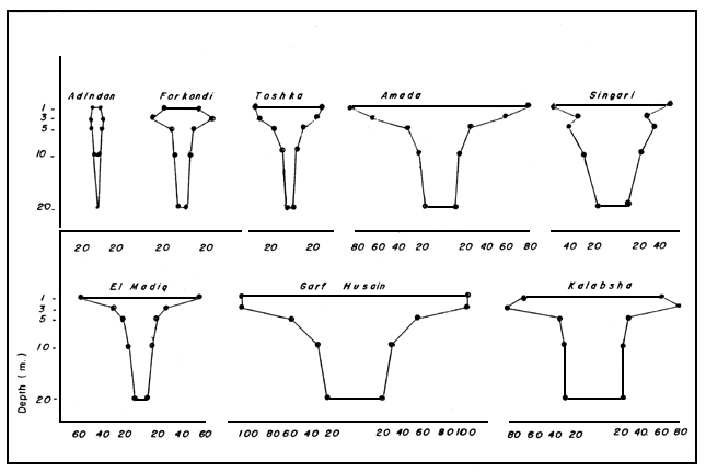
Figure 7 Vertical distribution of zooplankton (in number per cubic metre) at seven stations on the main channel of Lake Nasser
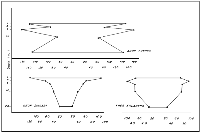
Figure 8 Vertical distribution of zooplankton (in number per cubic metre) in three khors off Lake Nasser
Age-group length tables for the main fish species are given in Table 12, as calculated according to Latif (1984).
Table 12 Calculated lengths (cm) for different age groups of fish
| Species | I | II | III | IV | V | VI | VII | VIII |
| Tilapia galilaea | 18.6 | 24.8 | 28.1 | 32.0 | ||||
| Alestes nurse | 3.8 | 6.0 | 7.8 | 9.4 | 11.4 | 30.1 | 54.0 | 90.6 |
| Eutropius niloticus | 10.7 | 15.4 | 20.7 | 24.6 | 26.3 | 47.5 | 40.5 | |
| Tilapia nilotica | 21.0 | 30.8 | 36.5 | 41.8 | 45.0 | 36.3 | 85.3 | |
| Alestes baremose | 6.4 | 12.5 | 19.3 | 26.5 | 32.5 | 78.2 | ||
| Lates niloticus | 13.9 | 25.2 | 55.0 | 62.0 | 70.1 | |||
| Species | IX | X | XI | XII | XIII | XIV | XV | XIX |
| Lates niloticus | 96.7 | 103.0 | 110.9 | 119.7 | 126.6 | 152.0 | 165.0 | 175.0 |
![]()
![]()
![]()