![]()
![]()
![]()
by
L.I. Braimah
Formerly Project Co-Manager, IDAF,
Yeji, Ghana
| ABSTRACT |
| No significant limnological change has been reported in Lake Volta since earlier studies. |
| The influx of fishermen and associated increased population pressure have led to an overexploitation of the resources. Fish stocks are subject to excessive fishing pressure, while, concomitantly, the main food source of the fish stocks - periphyton attached to submerged trees - is threatened as the trees are increasingly cut during drawdown periods because of the increased demand for firewood. |
| Although the estimated total yield of 36 360 t in 1991 does not appear to be far removed from the long-term yield of 40 000 t/year predicted by Vanderpuye, fishing effort (i.e., the number of fishermen) is believed to have increased at least four-fold over the period 1971–1990. Low yields of gill net catches have led to the introduction of a whole range of new fishing techniques, including semi-mechanized purse seining and beach seining, which have aggravated the overfishing situation. Although many of these new methods are prohibited, there is no effective control. |
| Traditional experimental gill net catches no longer reflect commercial catch magnitude and composition. |
| Fisheries development activities resumed in the reporting period through the UNDP/FAO IDAF Project, and included an element of research in the Yeji area of the lake. For lack of data, some of the findings in this area were extrapolated to estimate the lakewide situation. |
This document is an update of a report on Fisheries and Limnology of Volta Lake, prepared by Vanderpuye (1984).
The limitation of the update is attributable to the fact that since the termination of the FAO Volta Lake Research and Development Programme (VLRDP) in 1978, no organization or institution endeavoured to continue work on limnology and biology until 1989, when the University of Ghana and the Institute of Aquatic Biology (IAB) undertook an investigation into the limno-chemistry and biology of the lake.
This document analyses data on commercial fish landings kept over the years by personnel of the Department of Fisheries stationed in almost all the major marketing centres along the lake, as well as estimations of total commercial landings, species compositions, etc., for all the eight strata of the lake.
The fishery itself is dominated by newly introduced and alien fishing methods, most of which are nominally illegal, but which provide as much as 65–70% of the total fish landings in the marketing centres. The newly introduced gears tend to be species specific, unlike the gears deployed on the lake in the 1970s and early 1980s. Studies on the effect of such species-specific exploitation were begun at the same time as other studies on various biological parameters. These were an activity of the Integrated Development of Artisanal Fisheries (IDAF) project, based at Yeji since its inception in 1989. Outputs of this project have been extensively used, and form the major source for this update.
After the closure of the dam in 1964, the lake reached its maximum level of 84 m in 1968. Seasonal variations were relatively moderate until 1975, when the water level started to drop. In June 1984, the lake reached an unprecedentedly low level of 71.9 m. At this level the lake had shrank to roughly half of its maximum size. Since then, the lake level has fluctuated, but has been generally rising. The lake reached its maximum level again in 1989, and again in 1991 (Figure 1).
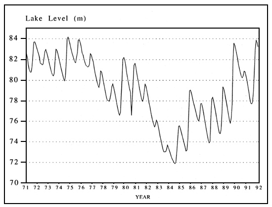
Figure 1 Lake levels at Akosombo in the period 1971 to 1991
Physio-chemical data collected by Antwi (1990) at Ajena in 1989, 25 years after dam closure, are summarized in Table 1. His observations are in line with those of Biswas (1966) and Obeng-Asamoah (1984).
The lake is warm polymictic. Stratification is fairly stable in the period April–June, but frequently broken down in the rest of the year by southerly and harmattan winds, and the annual floods.
Conductivity values ranged between 67.87 and 75.10 μmhos/cm at 25°C and total dissolved solids (TDS) between 30.60 mg/l and 37.92 mg/l in 1989. Obeng-Asamoah (1984) noted that the Ph of the surface water was about 7, declining with depth to 6.45 in the anoxic water near the bottom of the lake. Total alkalinity increased during the filling and post-impoundment phases (Biswas, 1966) and a total alkalinity of 41 mg CaCO3/l was observed in 1989.
The nutrient content of the lake has generally remained low, and only traces of phosphate, nitrate, nitrite, ammonia and sulphate have been recorded in the upper 40 m of the lake, while measurable quantities of these ions were recorded in the bottom waters. The low nutrient content was attributed to the catchment area itself being poor in nutrients, and also due to the low solubility of the pre-Cambrian rock granites found in the upper catchment area (Antwi, 1990).
Mean Secchi disc transparency was 2.2 m in 1989 (Antwi, 1990). The depth of light penetration was drastically reduced during the flood period (July to September) and during the harmattan seasons, as also observed by Biswas (1966).
Gross primary productivity measurements at the surface estimated by Antwi (1990) are shown in Table 2. In general the primary productivity values were low, ranging from 0.2 g C/m3/day to 1.35 g C/m3/day due to the limited supply of nutrients.
Table 1 Physico-chemical data at Ajena, Volta Lake
| Parameter | DEPTH | ||||||||||
| 0 m | 1 m | 5 m | 10 m | 15 m | 20 m | 30 m | 40 m | 50 m | 60 m | 70 m | |
| Temperature (°C) | 29.1 | 28.7 | 28.6 | 28.1 | 27.8 | 27.5 | 26.8 | 26.7 | 26.5 | 26.1 | 26.1 |
| pH | 7.0 | 7.1 | 7.1 | 6.9 | 6.9 | 6.9 | 6.7 | 6.7 | 6.7 | 6.6 | 6.6 |
| Oxygen (mg/l) | 11.8 | 8.5 | 8.8 | 7.5 | 5.9 | 5.0 | 4.6 | 3.0 | 2.2 | 1.8 | 0.4 |
| Oxygen (% sat.) | 138.1 | 110.8 | 87.1 | 86.7 | 67.0 | 60.0 | 49.4 | 35.7 | 24.5 | 17.7 | 5.9 |
| Acidity (mg/l CaCO3 | 16.8 | 16.9 | 17.8 | 17.7 | 17.7 | 18.5 | 18.2 | 19.1 | 19.6 | 20.8 | 24.1 |
| Alkalinity (mg/l CaCO3 | 40.8 | 40.7 | 40.6 | 41.5 | 42.4 | 40.4 | 41.1 | 42.8 | 41.8 | 40.3 | 39.9 |
| Total hardness (mg/l CaCO3 | 27.1 | 27.3 | 27.9 | 26.9 | 28.0 | 25.8 | 29.1 | 31.3 | 28.9 | 26.9 | 26.1 |
| TDS (mg/l) | 34.9 | 35.1 | 37.0 | 37.9 | 34.5 | 33.9 | 34.2 | 34.7 | 35.4 | 35.2 | 30.8 |
| Conductivity (μmhos/cm at 25°C) | 68.8 | 67.9 | 74.8 | 64.8 | 67.3 | 68.7 | 69.6 | 68.6 | 71.2 | 72.6 | 75.1 |
| Sodium (mg/l) | 3.9 | 4.0 | 4.2 | 4.0 | 3.8 | 4.0 | 3.9 | 3.8 | 3.8 | 3.1 | 3.8 |
| Potassium (mg/l) | 2.1 | 2.3 | 2.4 | 2.0 | 2.6 | 2.3 | 1.9 | 2.0 | 2.0 | 2.2 | 3.0 |
| Calcium (mg/l) | 5.7 | 5.8 | 5.8 | 5.4 | 5.4 | 5.5 | 5.1 | 6.0 | 5.8 | 6.0 | 6.1 |
| Magnesium (mg/l) | 4.2 | 4.0 | 4.2 | 4.1 | 4.6 | 3.8 | 4.7 | 5.2 | 4.4 | 3.9 | 3.5 |
| Chloride (mg/l) | 7.7 | 7.5 | 7.7 | 7.5 | 7.6 | 7.5 | 7.6 | 7.6 | 7.6 | 7.3 | 7.3 |
| Orthophosphate (μg/l) | 3 | 4 | 2 | 3 | 7 | 4 | 6 | 8 | 18 | 27 | 240 |
| Nitrate (μg/l) | 50 | 40 | 70 | 40 | 40 | 50 | 80 | 110 | 130 | 180 | 190 |
| Nitrite (μg/l) | 5 | 13 | 6 | 6 | 6 | 40 | 20 | 20 | 90 | 90 | 50 |
| Ammonium (μg/l) | 10 | 20 | 10 | 10 | 2 | 6 | 40 | 50 | 100 | 110 | 270 |
| Silicate (mg/l) | 3.1 | 3.1 | 3.1 | 3.0 | 3.0 | 3.3 | 3.7 | 3.4 | 2.8 | 3.5 | 5.4 |
| Sulphate (mg/l) | 0.2 | 0.6 | 0.4 | 0.3 | 0.3 | 0.4 | 0.3 | 0.7 | 0.7 | 0.8 | 6.2 |
| Secchi disc (m) | 2.2 | ||||||||||
Notes: Values are mean (x) over sampling period: February to December, 1989. Sampling frequency: once a month.
(Source: Antwi, 1990)
Table 2 Gross primary productivity measurements at Ajena in 1989
| Depth | Month | Gross primary productivity (g C/m3/day) |
| 1 metre | April | 0.20 |
| 1 metre | May | 0.48 |
| 1 metre | August | 1.27 |
| Surface (0 m) | September | 0.20 |
| 1 metre | September | 0.20 |
| Surface (0 m) | October | 0.20 |
| 1 metre | October | 0.20 |
| Surface (0 m) | November | 1.35 |
| 1 metre | November | 1.32 |
(Source: Antwi, 1990)
Plankton in the southern part of the lake was quantitatively poor and the number of species low (Rajagopal, 1969), and algal blooms were only observed occasionally in some areas (Obeng-Asamoah, 1984). The number of species was just over twenty and confined to not more than 10 genera. The most abundant species were Synedra and Melosira for the main channel, while Oscillatoria dominated the shallow arms and inshore areas. Eudorina and Volvox also occurred in relatively large numbers (Obeng-Asamoah, 1984).
As observed by Biswas (1966), the rotifers formed the major constituent (about 90%) of the zooplankton; and copepods, cladocerans and protozoa were present in much smaller numbers (Obeng-Asamoah, 1984).
The flooded trees in Volta Lake provide a substrate for periphyton in the epilimnion of the inshore and offshore areas (Vanderpuye, 1984). The bulk of invertebrate organisms living on the mats of periphyton are members of the following taxa: Ephemeroptera (Povilla adusta and, less commonly, the mayflies), Diptera (chironomids), Trichoptera and Coleoptera.
Examination of the commercial catches in 1991 shows that 52% of the fish caught depend on these aquatic organisms. Vanderpuye's solution of having cleared and uncleared parts in the lake is valid as long as a suitable balance is struck in order not to inhibit the survival of these aquatic organisms.
Over the years, fishermen have found the petrified submerged trees very useful and effective fuel for fish processing (smoking), and have started to exploit them at an alarming rate, cutting them during drawdown periods. The drought of 1984 reduced the lake to half of its maximum size and at this half capacity a significant percentage of the submerged trees were exposed to exploitation as firewood. Large expanses of submerged trees are also being cleared to make room for increased beach seine operations. These practices, although escalating, are not yet sufficiently significant to offset the predominance of the periphytonic biomass over the benthic.
According to Baranov (1961), Ioeffe (1961) and Tyurin (1961), large reservoirs can be placed in one of five categories, using fish production or benthic production levels as criteria (Table 3).
Table 3 Classification of reservoirs by fish production and by benthic production
| Trophic state of reservoir | Fish production (kg/ha/year) | Benthic biomass production (kg/ha) |
| Oligotrophic | 2–7 | <15 |
| Oligotrophic-mesohumic | 7–15 | 15–30 |
| Mesohumic-mesotrophic | 15–30 | 30–60 |
| Mesotrophic-eutrophic | 30–60 | 60–120 |
| Eutrophic | >60 | >120 |
On the basis of Table 3, Volta Lake, having a yield of 42–52 kg/ha/yr, is mesotrophic-eutrophic, rather than the oligotrophic that might be assumed based on the nutrient content (Antwi, 1990). The possible reconciliation of this paradox was outlined by Obeng-Asamoah (1977). The essential nutrients released by the breakdown and mineralization of the organic load are immediately picked up by the algae and Ceratophyllum. This process is fuelled by the high water temperature, resulting in quick turnover and high net productivity. Consequently, the measurement of the TDS alone gives an erroneous picture of the nutrient status of the lake: hence the conclusion of oligotrophy.
The potential fish yield calculated with the Morpho-edaphic Index Model was approximately 12 kg/ha, while the fish yield based on catch statistics for the lake in 1991 was 43.4 kg/ha (Table 4).
Table 4 Catch statistics for Volta Lake in 1991
A. Total processed fish landings (FWE in kg)
| Fish Market | Stratum | Total processed fish (FWE - kg) | Total processed per stratum (kg) |
| Yapei* | VIII | 882 450 | |
| Bupei | VIII | 3 688 137 | 4 570 587 |
| Yeji | VII | 9 891 411 | |
| Makango | VII | 307 196 | 10 198 608 |
| Kete-Krachi* | VI | 1 815 303 | 1 815 303 |
| Dambai | V | 1 443 130 | 1 443 130 |
| Kwame-krom | IV | 1 198 732 | |
| Tapa-Abotoase | IV | 1 641 181 | 2 839 913 |
| Kpando-Torkor | III | 2 399 783 | 2 399 783 |
| Dzemeni | II | 1 047 617 | 1 047 617 |
| Nketepa* | I | 5 309 328 | 5 309 328 |
| TOTAL | 29 624 270 |
B. Estimated yield based on catch statistics in 1991
| Total processed fish landings in 1991 | 29 624 t | |
| Total landings of fresh fish in 1991 | 1 464 t | |
| Total fish landings | 31 088 t | |
Plus adjustment for self-consumption by fisherfolk (11.7% of total landings) | 3 636 t | |
Plus adjustment for post-harvest losses (5.3% of total landings) | 1 636 t | |
| Total fish production from Volta Lake | 36 360 t | |
| Surface area of Lake at 275 ft water level | 837 617 ha | |
| Therefore estimated yield in 1991 | 43.4 kg/ha |
Volta Lake has been divided into 8 strata for recording purposes (Figure 2).
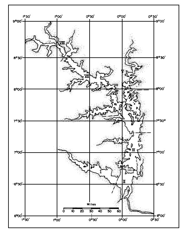
Figure 2 Map of Volta Lake, showing the eight strata
Two major frame surveys - in 1970 and 1975 - provided details on the fishing effort on Volta Lake (Table 5) (Bazigos, 1970; Coppola and Agadzi, 1976). Since the last survey, in 1975, no surveys have been carried out. However, socio-economic studies conducted in 1989 by Agyenim-Boateng (1989) and in 1991 by Maembe (1991) provided updates on some of the elements for Stratum VII (the Yeji part) of the lake (Table 6).
As there are currently no plans to execute a frame survey to cover the entire lake, a crude estimate has been made for the whole lake using the data collected for Stratum VII. The estimated fishing effort (fishing sites, fishermen and canoes) for 1991 is given in Table 5. On the basis of that estimate, the number of fishermen on the lake obtained would have been 82 460, while the official figure often quoted by the Fisheries Authorities was 80 000. This represents a four-fold increase over the period 1971–1990.
Table 5 Fishing effort for the whole lake, based on 1970 and 1975 frame surveys, and estimation of fishing effort for the whole lake in 1991, based on developments in Stratum VII
| Year | No. of fishing sites | No. of fishers | No. of canoes | No. of gear per day | |||
| Gill net | Cast net | Line | Other | ||||
| 1970(1) | 1 259 | 18 358 | 12 074 | 56 921 | 323 | 9 504 | 15 993 |
| 1975(2) | 1 479 | 20 615 | 13 814 | 61 107 | 367 | 10 472 | 434 |
| 1991(3) | 2 500 | 82 460 | 46 277 | - | - | - | - |
Sources: (1) Bazigos, 1970;
(2) Coppola and Agadzi, 1976;
(3) Estimate based on stratum VII (see Table 6).
Table 6 Fishing effort for Stratum VII (1975, 1989 and 1991)
| Period | No. of fishing sites | No. of fishers | No. of canoes | No. of canoes with engine | |||
| 1975(1) | 202 | 100% | 4 562 | 100% | 1 913 | 100% | 0 |
| 1989(2) | 190 | 15 581 | 4 266 | 259 | |||
| 1991(3) | 342 | 169% | 18 302 | 401% | 6 407 | 335% | 421 |
Sources: (1) From Coppola and Agadzi, 1976;
(2) From Agyenim-Boateng, 1989. Note that minor villages were grouped under group names;
(3) From Maembe, 1991.
All the fishing inputs have increased by leaps and bounds over the years and the effectiveness of fishing increased due to new and more effective fishing gears and more and larger outboard engines. The combination of these factors has resulted in increased fishing efficiency and increased fishing pressure on the stocks.
In 1970 and 1975, the principal fishing gears used on the lake were gill nets, cast nets, lines and traps (Bazigos, 1970; Coppola and Agadzi, 1975). The gill nets used in the 1960s and 1970s ranged from 102 to 205 mm (Vanderpuye, 1984), but the smallest have now been reduced to below 25 mm.
Recently, other gears have been introduced (Braimah, 1989, 1991) including drivein gear (wangara), bamboo-pipe fishing (specifically for Chrysichthys), combined gill nets and traps (nifa nifa) and some active gears, such as beach seines (adranyi), purse seines (winched) and other forms of encircling gear. These active gears are supposedly illegal on the lake, but currently contribute between 65 and 70% of the total fish landings of the lake (unpublished IDAF report, 1990).
The introduction of purses seines (winch nets) on the lake since the mid-1980s was concomitant with the deployment of a new type of craft for fishing, called a winch boat. This craft has a length overall of 9 to 13 m and a breadth of over 1 m. The incorporation of an operational deck allows 10 to 15 fishermen to stand easily while working with the net, which can be as long as 500 to 800 m and 20 to 30 m deep. The normal canoes are still the most prevalent, but their capacity has commonly increased from 6 to 7 boards to 10 to 12, and lengths range between 5 and 10 m, with 2 to 4 fishermen.
Most of the fishermen are forced to fish in inshore waters due to the activity of winch net operators (purse seiners), who foul nets of other fishermen during operations in the offshore area because due to the presence of tree stumps, purse seines are used only in the original river bed.
Until 1975, there were no transport boats on the lake (Coppola and Agadzi, 1976), while currently there are nearly 1 000 boats, with the Yeji market alone visited by over 100 (Agyenim-Boateng, 1989; Maembe, 1990). These boats - with an overall length of 13 to 20 m and a breadth between 2.2 and 2.5 m (van der Straten, 1990, 1991) - have now become, throughout the lake, the major means of transportation, instead of canoes.
The 1975 frame survey of the lake did not mention the presence of any outboard motors for propulsion. Agyenim-Boateng (1989) recorded 259 outboard motors, while in 1991, Maembe found 421, an increase of about 63% in two years. These outboard motors ranged between 9.9 and 45 HP. A few gill net and long-line fishermen use outboards, mostly of 9.9 and 15 HP, while the purse seine operators use mainly 25 HP motors. The lake transporters operate the 45 HP engines, of which they often have 2 or 3 mounted on the transom of the boat.
Fish production figures for Volta Lake from its creation in 1964 to 1979 are given by Vanderpuye (1984). Fish production in 1991, estimated from commercial landings at the marketing centres along the lake, was 36 360 t (Table 4). The fish yield pattern showed an initial steady rise to a maximum of almost 62 000 t in 1969 - the highest yield ever recorded for a man-made lake - followed by a decline and stabilization at around 40 000 t. The 1991 figure is not at variance with the statistical prediction of Vanderpuye that annual fish production would fluctuate around 40 000 t/yr. Fishing effort, however, has probably increased more than fourfold (Table 5).
Length frequency data on 26 commercial important fish species collected by the IDAF project indicates that 17 fish species are caught before reaching the age of one year (Goudswaard and Avoke, 1993). The high mortality of the juvenile length classes of these fishes is caused by the extensive use of small-meshed gill nets and recently introduced active gears, such the purse and beach seines that provide between 65 and 70% of the total commercial landings (unpublished IDAF report, 1990). Lake level fluctuations and monthly commercial fish catches were recorded in the Yeji part of the lake from July 1989 to December 1991 (Figure 3). Fish catches were high when lake levels were low and vice versa. The general trend of monthly fish catches for the Yeji part of the lake is very much influenced by the high Tilapia catches (Figure 4). When lake levels are high, Tilapia catches are low, and vice versa.
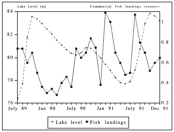
Figure 3 Lake levels and commercial catches in Stratum VII (July 1989 – December 1991)
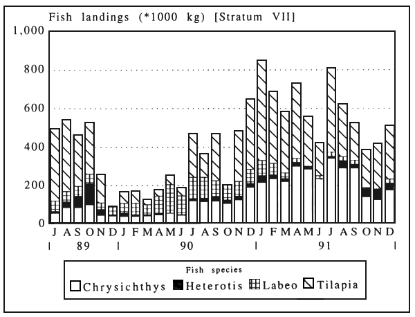
Figure 4 Landings of four species in Stratum VII (July 1989 – December 1991)
Table 7 Processed fish landings (fresh weight equivalent (FWE) in kg), Volta Lake, 1991, based on recorded figures
| SPECIES | MARKET | ||||||||||||||||
|---|---|---|---|---|---|---|---|---|---|---|---|---|---|---|---|---|---|
| Buipe | Yeji | Makango | Dambai | Tapa-Abot. | Kwame-krome | Kpando | Dzemeni | Total | |||||||||
| FWE in kg | % | FWE in kg | % | FWE in kg | % | FWE in kg | % | FWE in kg | % | FWE in kg | % | FWE in kg | % | FWE in kg | % | % | |
| Lates | 4 916 | 0.1 | 128 422 | 1.3 | 290 | 0.1 | 53 842 | 3.7 | 168 500 | 10.3 | 64 545 | 5.4 | 140 902 | 5.9 | 121 949 | 11.6 | 3.2 |
| Hemichromis | 0 | 0 | 0 | - | 0 | - | 0 | - | 0 | - | 254 | <0.1 | 4 558 | 0.2 | 0 | - | 0 |
| Tilapia | 823 601 | 22.3 | 2 898 567 | 29.3 | 54 891 | 17.9 | 318 406 | 22.1 | 142 586 | 8.7 | 295 533 | 24.7 | 839 632 | 35.0 | 216 767 | 20.7 | 25.9 |
| Heterotis | 101 109 | 2.7 | 228 774 | 2.3 | 2 140 | 0.7 | 44 085 | 3.1 | 102 623 | 6.3 | 49 800 | 4.2 | 41 478 | 1.7 | 38 983 | 3.7 | 2.8 |
| Clupeidae | 0 | - | 91 892 | 0.9 | 10 228 | 3.3 | 1 921 | 0.1 | 278 | <0.1 | 5 984 | 0.5 | 0 | - | 91 | <0.1 | 0.5 |
| Labeo | 294 957 | 8.0 | 338 973 | 3.4 | 10 298 | 3.4 | 38 447 | 2.7 | 9 593 | 0.6 | 1 976 | 0.2 | 788 | <0.1 | 370 | <0.1 | 3.2 |
| Mormyridae | 101 852 | 2.8 | 286 471 | 2.9 | 7 142 | 2.3 | 39 965 | 2.8 | 43 954 | 2.7 | 21 506 | 1.8 | 85 093 | 2.7 | 25 108 | 2.4 | 2.7 |
| Hydrocynus | 16 076 | 0.4 | 41 606 | 0.4 | 690 | 0.2 | 53 462 | 3.7 | 251 948 | 15.4 | 165 697 | 13.8 | 321 962 | 13.4 | 130 608 | 12.5 | 4.5 |
| Alestes | 93 419 | 2.5 | 63 545 | 0.6 | 1 680 | 0.5 | 18 962 | 1.3 | 0 | - | 857 | 0.1 | 4 466 | 0.2 | 4 489 | 0.4 | 0.9 |
| Citharinus | 347 282 | 9.4 | 257 696 | 2.6 | 10 172 | 3.3 | 216 903 | 15.0 | 126 376 | 7.7 | 45 735 | 3.8 | 3 033 | 0.1 | 1 360 | 0.1 | 4.7 |
| Distichodus | 29 492 | 0.8 | 16 982 | 0.2 | 0 | - | 11 180 | 0.8 | 51 644 | 3.1 | 4 282 | 0.4 | 1 340 | 0.1 | 1 487 | 0.1 | 0.5 |
| Schilbeidae | 100 501 | 2.7 | 205 187 | 2.1 | 8 484 | 2.8 | 12 813 | 0.9 | 3 068 | 0.2 | 26 423 | 2.2 | 7 842 | 0.3 | 0 | - | 1.7 |
| Bagrus | 71 983 | 2.0 | 215 756 | 2.2 | 8 200 | 2.7 | 56 838 | 3.9 | 142 580 | 8.7 | 78 158 | 6.5 | 703 782 | 29.3 | 102 941 | 9.8 | 6.4 |
| Synodontis | 988 495 | 26.8 | 1 434 162 | 14.5 | 45 362 | 14.8 | 221 007 | 15.3 | 281 617 | 17.2 | 127 624 | 10.6 | 232 786 | 9.7 | 88 786 | 8.5 | 15.4 |
| Chrysichthys | 480 324 | 13.0 | 3 451 443 | 34.9 | 121 226 | 39.5 | 236 364 | 16.4 | 273 074 | 16.6 | 275 259 | 23.0 | 0 | - | 162 582 | 15.5 | 23.1 |
| Auchenoglanis | 25 231 | 0.7 | 0 | - | 0 | - | 51 239 | 3.6 | 4 053 | 0.2 | 10 060 | 0.8 | 0 | - | 37 643 | 3.6 | 0.6 |
| Gymnarchus | 24 011 | 0.7 | 67 951 | 0.7 | 0 | - | 6 418 | 0.4 | 413 | <0.1 | 2 106 | 0.2 | 0 | - | 24 365 | 2.3 | 0.6 |
| Clarias | 184 889 | 5.0 | 163 984 | 1.7 | 26 394 | 8.6 | 45 270 | 3.1 | 36 437 | 2.2 | 19 233 | 1.6 | 0 | - | 48 841 | 4.7 | 2.4 |
| Others | 0 | - | 0 | - | 0 | - | 16 007 | 1.1 | 2 439 | 0.1 | 3 600 | 0.3 | 32 125 | 1.3 | 41 247 | 3.9 | 0.4 |
| TOTAL | 3 688 137 | 100 | 9 891 412 | 100 | 307 196 | 100 | 1 443 130 | 100 | 1 641 182 | 1 198 732 | 2 399 783 | 1 047 617 | 100 | 100 | |||
| VIII | VII | V | IV | III | II | ||||||||||||
| STRATUM | |||||||||||||||||
During floods, turbid flood water (usually referred to as white water) can be traced well past Kete-Krachi in Stratum VI. The whole northern arm then becomes riverine, which induces fish to spawn. Tilapias avoid such turbid currents and hence are very rare in the catches during floods.
In the period April – June 1991, fish catches were not high, although lake levels were low. This was caused by the fact that the new Fisheries Law of 1991 was launched at Yeji in April 1991. It explicitly banned the use of all active gear on the lake. To begin with, the law was observed, but when it became clear that a mechanism for enforcement was lacking, fishing with these banned gears started again full force.
![]()
![]()
![]()