![]()
![]()
Opening of the Session
Introduction of the Terms of Reference
Presentation of Regional Summaries
Models for Calculating Phosphorus Loads in Lakes
Compilation of Report on Phosphorus in African Lakes
Future Work Programme
Review and Approval of the Report
Closure of the Session
Charles A. BINEY
Director
Water Research Institute
P.O. Box 38
Achimota
Ghana
Tel.: (+233-21) 775135
Fax: (+233-21) 761030
E-mail: [email protected]
Frederick W.B. BUGENYI
Director of Research
Fisheries Research Institute
P.O. Box 343
Jinja
Uganda
Tel.: (+256) 43 22071
Fax: (+256) 43 20192/22050
E-mail: [email protected]
William R.HARDING
Science Service Branch
City Engineer's Department
P.O. Box 1694
Cape Town 8000
South Africa
Fax: (+27)21 8552528
E-mail: [email protected]
Marcel Aka KOUASSI
Centre de Recherches Océanologiques
B.P. V18
Abidjan
Côte d'Ivoire
Tel.: (+225) 355014/355880
Fax: (+225) 351155
E-mail: [email protected]
C.H.D. MAGADZA*
Lake Kariba Research Station
University of Zimbabwe
P.O. 48
Kariba
Zimbabwe
Fax: (+263) 61 2707
E-mail:
[email protected]
Massoud A.H. SAAD
Department of Oceanography
Faculty of Science
University of Alexandria
Moharem Bey
21511 Alexandria
Egypt
Tel.: (+203) 4226485
Fax: (+203) 4834381
Tolu OREKOYA
Environment & Development Consultancy Services (EDCS)
Plot 144/145 Bawaleshie Otele, East Legon
Accra
Ghana
Tel./Fax: (+233-21) 507340/41
E-mail: [email protected]
Jeffrey A. THORNTON*
International Environmental Management Services Limited
321 Barney Street
Waukesha, Wisconsin 53186
USA
Tel.: (+1-414) 5741225
Fax: (+1-414) 5741225
E-mail: [email protected]
SECRETARIAT
H. NAEVE (Technical Secretary)
Fishery Resources Division
Food and Agriculture Organization of the United Nations
Viale delle Terme di Caracalla
00100 Rome,
Italy
Tel.: (+39-6) 570 56442
Fax: (+39-6) 570 53020
E-mail: [email protected]
W.Q-B. WEST (Secretary, CIFA)
FAO Regional Office for Africa
P.O. Box 1628
Accra
Ghana
Tel.: (+233-21) 666851-4/244051 (13 lines)
Fax: (+233-21) 233999/668427
E-mail: [email protected]
| Doc. 1 | Agenda | |
| 2 | Task of Working Party | |
| 3 | Eutrophication in African Lakes with particular reference to Phosphorus Loading, by W.R. Harding and J.A. Thornton | |
| 4 | Phosphorus in the Egyptian Lakes representing the Northern African Lakes, by M.A.H. Saad | |
| 5 | Assessment of Eutrophication Problems in the Water Bodies of Western Africa, by A.M. Kouassi | |
| 6 | Phosphorus Loading and Future Potential Effects in the Eastern African Lakes Region, by F.W.B. Bugenyi, J.S. Balira and R. Mugidde | |
| 7 | Regional Report on southern Africa, by C.H.D. Magadza | |
| 8 | Phosphorus Modelling of African Lakes, by W.R. Harding and J.A. Thornton | |
| 9 | Draft Report of the Session | |
| Inf.1 | List of Participants | |
| Inf.2 | List of Documents |
INTRODUCTION
The African continent is one part of the planet where inland water resources contribute most to the nutrition and welfare of the populations. The conservation and planned utilization of national resources in general and freshwater resources in particular represent one of the major challenges facing the continent today.
The diversity of African lakes is enormous. Not only does the continent span two temperate zones and a range of eco-regions, it contains lakes which, in terms of size, encompass some of the world's largest (Lake Victoria), and deepest (Lake Tanganyika) lakes, to the largest man-made impoundment, Lake Volta. Diversity of lakes, and to the internally-drained saline (soda) lakes of East Africa. Examples of almost all of the natural mechanisms which result in lake formation may be found in Africa. Finally, the continent is fringed by an equally-diverse array of wetlands and shallow water bodies.
In many African countries, most major cities are located on the shores of water bodies. Rapid population increases (as well as industrial and urban development) have resulted in discharges of large quantities of wastes into these water bodies often causing eutrophication.
Eutrophication is a process whereby water bodies become progressively enriched with the plant nutrients nitrogen and phosphorus. The process occurs naturally, over geological time, or may be accelerated due to allochtonous anthropogenic impacts, often termed ‘cultural’ eutrophication, besides the autochthonous phosphorus released from lake sediments. Phosphorus, and to a lesser degree, nitrogen, have been identified as the major causes of eutrophication in surface waters.
Many instances of eutrophication have been recorded in Africa. Some of the largest Central African lakes have been subjected to anthropogenic impact for some time, with the result that their ecological functioning and floral and faunal balances have become grossly disturbed. Artisanal fishermen have abandoned some of the Nigerian coastal lagoons for similar reasons. The easily-visible consequences of this, for example the spread of water hyacinth and the increasing incidence of cyanobacterial blooms, are all too apparent across the length and breadth of the continent. Although there is little documented evidence, it is nevertheless clear that increasing levels of phosphorus are instrumental to the observed changes in trophic state of many of the surface waters of the African continent. In addition, the environmental problems caused by nutrient enrichment are aggravated by discharge of other pollutants, and/or the application of environmentally-unsound fishing practices.
Although understanding of the interactive processes associated with eutrophication is a necessity, relatively limited information is available on such process covering tropical and sub-tropical regions globally and in Africa in particular. This report is a first attempt by the Working Party to pinpoint the problems related to phosphorus discharges. This issue is intended to be treated in a broader, more complete way in a subsequent technical paper.
EASTERN AFRICA
Thirteen lakes, covered within eight countries have been considered for phosphorus (P) loading and the potential threats due to eutrophication process. The Eastern African Great Lakes exhibit a great range of morphometrics and geological settings within a tropical climate which has been shown to vary greatly. Some of these lakes (e.g. Lakes Victoria and George) are in a state of environmental siege, and some of the world's great endemic vertebrate faunas are now facing extinction. Concerns have been raised about the health and conservation of some of these in regards to commercial overfishing, species introductions, technological developments and a range of human activities (as a result of population growth) which have affected and/or are affecting their marvellous biotic diversity.
Lake Victoria is eutrophic and has total phosphorus (TP) concentration of 2–4 μM1-1. Its chlorophyll concentration now is 12–23 mg1-1 (compared to 2–4 mg1-1 historically). Its lake edges are fringed with extensive wetland swamps which have been significant in the evolution of the fauna and in the regulation and filtration of nutrients and pollutants. The growing population is threatening the existence of these too.
Lake George, one of the most productive tropical lakes has TP concentrations 12–70 μg1-1 and chlorophyll concentration, 110–210 mg m-3, is threatened by human subsistence agricultural and other activities too. In Lakes Tanganyika, Malawi and Turkana where the lakes themselves are larger (and deeper) the respective inputs of TP are 4–7 μg1-1, 0.1–0.2 mg1-1 and 22.6 mg1-1. The respective chlorophyll concentrations too are 0.7–4.6 μg1-1, 0.1–1–3 μg1-1 and 2–15 μg1-1 which are relatively less than for the eutrophic Lake Victoria. The data for (P) loading of these and other lakes in the region need collection and monitoring continuously for the proper management of the lakes environments if eutrophication is to be guarded against.
The Eastern African region should take the wiser decision of balancing between exploitation and conservation of the resources (i.e. management of the aquatic resources) in order to avoid aquatic environmental degradation.
NORTHERN AFRICA
Although phosphorus is important for phytoplankton growth, it is a potential pollution if it is found in an aquatic environment in abnormal concentrations, leading to eutrophication with the high nitrogen'load which constituted in the last decades a considerable problem in the Nile delta lakes. This resulted from allochthonous nutrient inputs (untreated sewage, industrial and agricultural wastes) and the autochthonous supply (decomposition of organic load within the lakes). The levels of eutrophication in these lakes are in the order. Lake Mariut>Lake Manzalah>Lake Edku>Nozha Hydrodrome>Lake Brollus. The Egyptian fish production depends mainly on these lakes and the great decrease in their fish catch was attributed to their pollution and land reclamation. The coastal Egyptian delta lakes, which are transitional zones between land and sea, are feeding mainly with huge amounts of contaminated drainage waters, except the Hydrodrome which receives polluted Nile water. The annual discharges into Lake Mariut, Lake Brollus and Lake Manzalah amount to 171, 3600 and 6657 106m3, respectively. The annual discharge into Lake Edku has increased to 178% after the High Dam. Lake Qarun, a shallow closed saline water body, lies in the western Egyptian desert and Lake Nasser, representing ⅔ of the High Dam Lake, was created after damming the Nile.
Lake Mariut was subjected since 1968 to numerous physico-chemical investigations, particularly on the phosphorus problem. All results confirm the abnormal high phosphorus levels in this lake reaching maximum values from 9.8 to 14.8 mgPO4/l, which were never recorded from it before or from the other Egyptian lakes. The Hydrodrome was separated from Lake Mariut in 1939 and received previously clean Nile water and thus it was used as a reference lake for illustrating the influence of pollution on the mother lake. Recently, however, the phosphorus data indicate that it was exposed to eutrophication, but at a lower degree compared which that of the mother lake. Based on the annual mean values, the phosphorus concentration in Lake Mariut was seven times higher than that of the Hydrodrome. The phosphorus contents in the other three delta lakes, connected to the sea, were also investigated by several authors during the last three decades. The data indicate that nutrient levels in these lakes are mainly controlled by their fluctuations in the drainage water discharges, as confirmed from the high phosphorus values in the lake areas near these discharges and the low values near the lake sea connections. The phosphorus species in the water and sediments of Lake Qarun have been recently investigated. Similar to delta lakes, the lake region influenced by drainage water discharges gave high values of the phosphorus species. The data of phosphorus forms in this lake sediments indicate that inorganic phosphorus was found to depend upon local sediment characteristics. The inorganic and total phosphate vertical data in Lake Nasser near the High Dam were parallel showing irregular variations. Phosphate was also investigated in some cores of this lake and the data have been compared together and with earlier ones.
SOUTHERN AFRICA
Most of the work reported on, on eutrophication processes were done in South Africa, and to a lesser extent, in Zimbabwe, and Zambia. South Africa, with only one natural lake, depends on man-made lakes for its water supply, to serve industries, homes, agriculture (irrigation), and recreational purposes. Many are also receptacles of treated effluents of sewage treatment plants. Inevitably, eutrophication of the water bodies has increased, and most of them now have nutrient levels exceeding that attributable to oligotrophic waters using the OECD boundary values for open trophic classification system. For example, Bloemhof lake in South Africa has an areal phosphate loading of 1801 g per m2 per year, while Hartbeespoort had 336 g per m2 per year; These two lakes were typical of lakes in urban and industrialized areas. In rural areas, total phosphorus was typically much lower (varying from 0.2 to 1 g per m2 per year). Phosphate loading measured in Zimbabwe varied from 0.1 to 18 g per m2 per year.
The problems have been tackled in most countries by imposing stringent standards or legislation to prevent nutrients entering the system (Hartbeespoort and Zeekoevlei lakes), or by diverting effluents to irrigation schemes (Zimbabwe's Mcllwaine lake). However, none of these measures has prevented eutrophication of water bodies, especially those near urban centres, even if treatment of industrial and domestic waste in southern Africa is of a very high degree. There is also extensive use of modelling to predict water levels of nutrients, with acceptable results.
WESTERN AFRICA
The West African water bodies are diverse and include coastal lagoons, natural lakes and reservoirs.
Large numbers of man-made lakes (of which the most important include Kainji, Volta, Retba, Guiers and Oguta reservoirs) have been constructed on the large West African rivers for multipurpose activities such as drinking water supply, power supply, recreation, livestock watering, irrigation, and fishing. West Africa is also dotted with vast numbers of small natural lakes and a large lake, Chad situated mainly in the Niger Delta region. Finally, the coastline of the region includes a range of large and shallow lagoons separated from the sea by a system of sand barriers. The Ebrié, Nokoué, Lagos, Togo, Songor, Keta and Sakumo lagoons are the most important.
Most studies relating to eutrophication in the region have been conducted in the coastal lagoons of the Gulf of Guinea. For the other water systems, there is also a growing body of limnological literature.
Selected morphological, chemical and productivity data on twelve West African bodies show that eutrophication problems do exist and the potential for them to get worse, if nothing is done, is very real.
Estimates of nutrients loads in domestic and industrial sewage for Abidjan in Côte d'Ivoire show that 300t/yr of total P enter the Ebrié Lagoon.
Currently, wide variations in phosphorus levels occur in water bodies of the region. These range from 0.004 mg/l in the oligotrophic Guiers Lake in Senegal to 0.5 mg/l in the mesotrophic Volta Lake in Ghana and to 10.6 mg/l in hypertrophic areas of the Kainji Lake in Nigeria.
Although the presence of blue-green algae and macrophytes in a water body is not exclusively associated with nutrient enrichment, dense blooms, typically of Microcystis aeruginosa and Pistia stratiotes and Eichhornia crassipes are a characteristic feature of these water bodies systems and cause a number of water quality and socio-economic problems in West African water bodies.
CONCLUSIONS
The successive increases in population in Africa have been accompanied by a considerable expansion in wastes discharges from point and non-point sources (domestic, industrial and agricultural).
Nutrients represent the main constituent of these wastes and thus their concentrations, particularly that of phosphorus, have dramatically increased in recent years, leading to eutrophication problems.
Eutrophication in several African lakes cannot be accurately evaluated, due to absence or lack of the relevant data and consequently limnological studies concentrating on nutrient loads, sources and pathways are highly needed.
There is the need for African Governments to initiate and/or support attempts at reducing discharges of nutrients, especially phosphorus, into African water bodies.
by
J.A. Thornton and W.R. Harding
1. Background
The use of models or mathematical tools for the classification and management of lakes throughout the world dates from the 1960s, when the advent of cost-effective computing systems made it possible to correlate a number of limnological variables in such a way as to provide limited predictive capability. The work of Sakamoto (1966) was seminal in this regard and provided the basis for early eutrophication modelling efforts in Africa (see Pieterse and Toerien, 1978).
The development of African lake models was, and to an extent continues to be, predicated upon the hypothesis that African lakes differ significantly in character from the north temperate lakes that, hitherto, have formed the basis of limnological paradigms (Thornton and Rast, 1987). This hypothesis not only provided the impetus for African limnology during the intervening decades since the 1960s but also, as a result of an extensive eutrophication research effort across the continent (but centred, to some extent, on southern Africa), led to the formulation of a quantifiable statement of these differences as the basis for managing the warm-water lakes of the continent (Allanson et al., 1990; Thornton and Rast, 1993; Harding and Thornton, 1997).
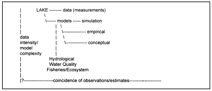
Figure 1. Diagrammatic representation of the range of phosphorus models available.
The term models, as used in this paper, includes a range of conceptual and mathematical formulations that are intended to provide a representation of in-lake and watershed conditions. Models range from purely descriptive conceptualizations of lake ecosystems (see Thornton and Rast, 1987, 1993) to sophisticated mathematical simulations of African lake ecosystems (Grobler and Silberbauer, 1984; Cochrane et al., 1987). Figure 1 represents the continuum of models types from actual measured data through conceptual models to simulation models, and summarizes the increasing complexity and data requirements of models as one moves from descriptive representations to simple empirical models to complex simulation models. While the latter types of models are most likely to provide realistic, accurate representations of in-lake processes, they are generally costly to construct and extremely data-intensive to operate, often to the point that their value for lake management is limited. (Such models do have an important role in elucidating our understanding of how African lakes function and how materials move through the various ecosystem elements.) In contrast, the empirical or “black box” models, constructed from average data from a wide range of lakes and lake types, are functional and easy to use but often ignore the individual peculiarities of specific lakes. The selection and use of models for lake management in Africa is discussed more fully below.
2. The African Lake Paradigm
The least complex type of model is the purely descriptive conceptual model which states in words how a lake ecosystem operates. In the African context, this type of conceptual model or paradigm has been most fully articulated for the warm-water lakes of southern Africa (Beadle, 1981; Davies and Walmsley, 1985; Thornton, 1987). In summary, the semi-arid lake paradigm states that the high coefficient of variations of annual river flow, combined with the lack of perennial rivers and natural lakes, create limnological conditions that differ markedly from the temperate zone lakes of the northern hemisphere (Table I). These differences are evidenced by greater turbidity, monomicism and more intense stratification, higher nutrient loading rates and in-lake concentrations, lower N:P ratios, and higher algal standing crops and production rates (Harding and Thornton, 1997) than are commonly reported from temperate lakes. Inherent in this model, also, is greater inter-and intra-annual variation in lake levels due to the hydrological variability (Alexander, 1985), and, in part, the reliance on man-made lakes for water supply and power generation purposes. Variations of this paradigm have been mooted for other parts of Africa, including East Africa with its abundant internally-drained (endorheic) saline lakes, generally at altitude, and West Africa with its abundance of coastal lagoon systems (Symoens et al., 1981). In both of these regions, however, the principle features of the southern African paradigm appear to remain relevant, especially for man-made lakes (Harding and Thornton, 1997).
3. Empirical Models
Empirical models are statistical representations of an average trend in the value of a given variable that may be discerned relative to another parameter; in effect a cause and effect relationship. Often it has been necessary to transform the data into a logarithmic form in order to define a straight line relationship. In the sphere of phosphorus budget modelling, these relationships are typically used to predict or estimate the algal response in one or more lakes that is likely to result from a given input of phosphorus. Such models, as has been noted above, were originally devised by Sakamoto (1966) and this type of phosphorus-chlorophyll model has been used extensively throughout the world. One of the first models of this type to be published for African lakes was the single lake relationship of Pieterse and Toerien (1978) identified in Roodeplaat Dam, South Africa:
| Log10 CHL = 1.232 (Log10P) - 0.509 | (1) |
where CHL = chlorophyll-a concentration in μg/l, and P = soluble reactive phosphorus concentration in μg/l P.
As a consequence of their work, further studies were conducted on a number of South African impoundments (Walmsley and Butty, 1980), and a more robust set of empirical relationships was developed that accounted for water clarity and limiting nutrient status:
| CHL = 203 (P) + 4.13 | (2) |
| CHL = 243.7 (P)(SDT) - 1.10 (P + 1/SDT) + 5.57 | (3) |
where CHL = mean epilimnetic (0–5 m) chlorophyll-a concentration in μg/l, P = soluble reactive phosphorus concentration in mg/l P, and SDT = Secchi disc transparency in m. Equation (2) was recommended for use in clear water, phosphorus limited lakes and equation (3) for use in turbid water,phosphorus limited lakes. Phosphorus limitation of algal growth was determined by an N:P ratio of >5,while turbidity was assessed on the basis of a Secchi disc transparency of <0.8 m.
Table I
The semi-arid African lake paradigm (from Thornton, 1987)
| Feature | Units | Semi-arid lakes | Temperate lakes |
| Seasonal inflow | Water residence time [Tw] (years) | 0.9 | 1 – 100 |
| Drought cycle | Coefficient of variation of rainfall (%) | 65 – 114 | 30 |
| Mixing Regime | -- | mono-/poly-mictic | dimictic |
| Morphology | Mean depth [z] (m) | 6.7 | 1.5 – 20.0 |
| Watershed:Lake area ratio [AD:A] | 183 | 20 | |
| Drawdown | Change in capacity (%) | up to 90% | minimal |
| Hydroclimate | Temperature (°C) | 10–30 | 0–20 |
| Turbidity | Secchi disc transparency [SDT] (m) | 1.1 | 1.0–10.0 |
| Oxygen depletion | Number of lakes studied (%) | 73 | few (?) |
| Nutrient tolerance | Nitrate [N] (mg/l) | 0.2 | 0.1 |
| Phosphorus [P] (mg/l) | 0.02 | 0.01 | |
| Nitrogen:Phosphorus ratio [N:P] | 3.5 | 12.0 | |
| Algal growth limiting nutrient | P | N | |
| Algal dominance | -- | Diatoms and Chrysophytes | Cyanophytes |
| Algal biomass | Chlorophyll-a [CHL] (μg/l) | 8 | 3 |
| Algal productivity | Primary production [PP] (g C m-3 d-1) | <30 | <0.3 |
While these linear regression models filled a need within the nascent lake management community for a means to assess the potential benefits of nutrient load reduction efforts on lake ecosystems, their limited number of variables lacked the conceptual elegance that reflected the multiple biotic and abiotic factors influencing the distribution of phosphorus in a lake water column. In order to better account for variability arising from sources other than algal uptake of phosphorus, Vollenweider (1968) developed a suite of phosphorus-lake response models which incorporated not only the biotic response, but also which were driven by watershed-derived phosphorus loads, modified for in-lake phosphorus retention as a function of hydrological regime:
| P = Lp/qs (1 + Tw0.5) | (4) |
where P = average in-lake total phosphorus concentration in mg/l, Lp = annual total phosphorus areal loading rate in mg/m2/year, qs = annual areal water loading rate in m/year (= z/Tw), Tw = hydraulic residence time in years, and z = mean depth in m.
To determine biotic responses in-lake, the term, P, was used in subsequent equations developed as part of the overall modelling effort, including a phosphorus-chlorophyll relationship. This relationship was subsequently further refined and published by the Organization for Economic Cooperation and Development (OECD, 1982) as the OECD suite of eutrophication response models. These latter models included modules that forecast not only chlorophyll-a concentrations but also primary production, Secchi disc transparency, and areal hypolimnetic oxygen depletion (Table II).
Table II
The combined OECD Study eutrophication response model suite (OECD, 1982)
| Model | Relationship | n | r | SE |
| Annual mean total phosphorus concentration (μg/l) | 1.55 P0.82 | 87 | 0.93 | 0.192 |
| Annual mean chlorophyll-a concentration (μg/l) | 0.37 P0.79 | 67 | 0.88 | 0.257 |
| Annual maximum chlorophyll-a concentration (μg/l) | 0.74 P0.89 | 45 | 0.89 | 0.284 |
| Annual mean Secchi disc transparency (m) | 14.7 P-0.39 | 67 | -0.69 | 0.237 |
| Areal hypolimnetic oxygen depletion rate (g O2/m2/day | ~0.1 P0.55 | -- | -- | -- |
| Primary Production | 31.1P0.54 56.6 CHL0.61 |
The applicability of the OECD suite of eutrophication response models to African lakes has been evaluated by a number of authors, including Thornton and Walmsley (1982), Grobler and Silberbauer (1984), Jones and Lee (1984), Walmsley and Thornton (1984), and Marshall (1984), who have found that these models to be generally applicable to African lakes. Nevertheless, in order to account for the consistent overestimation of in-lake phosphorus concentrations observed by Thornton and Walmsley (1982), Grobler and Silberbauer (1984) proposed the use of an enhanced abiotic sedimentation coefficient in turbid impoundments:
| P = W / (Q + SV) | (5) |
where P = in-lake phosphorus concentration in μg/l, W = total annual phosphorus load in kg,Q = total annual water inflow in 106 m3, S = phosphorus sedimentation coefficient (= 3.5 forHartbeespoort Dam, South Africa), and V = mean annual lake volume in 106 m3.
This P value is then used instead of the Vollenweider value of P, described in equation (4), to forecast chlorophyll-a concentrations and other eutrophication response parameters. This model was later automated for use in an interactive, decision support system for evaluating eutrophication control strategies (Grobler, 1986).
4. Simulation Models
The most complex lake models are simulation models which are designed to mimic the interactions between ecosystem components within a lake. These models tend to be lake-specific, with each of the rate coefficients used needing to be determined for the particular lake to which the model is fitted. Few of these models have been developed, and fewer still have been developed for African lakes. TROFIC is one such model developed for Hartbeespoort Dam, South Africa (Cochrane et al., 1987). This model was developed, using a FORTRAN V computer program, as a multiple compartment, mechanistic, deterministic, non-linear, phosphorus-based simulation model to evaluate management actions that included destratification, protein harvesting, and biomanipulation in addition to phosphorus removal. Such multiparameter assessments become difficult to achieve using simple empirical models due to the multiplication of errors through the various individual relationships that must be used (see Thornton et al., 1986). Prediction errors within the TROFIC model ranged from 20% to 50% of the observed values, and were considered to be within acceptable levels of accuracy given the complexity of the model.
Table III
Predicted and observed phosphorus and chlorophyll-a concentrations in Hartbeespoort Dam, South Africa (NIWR, 1985)
| Model | Year | P (μg/l) | Deviation (%) | CHL (μg/l) | deviation (%) |
| Observed | 1980–81 | 493 | -- | 31 | -- |
| 1982–83 | 634 | -- | 59 | -- | |
| TROFIC | 1980–81 | 347 | -30 | 29 | -7 |
| 1982–83 | 481 | -24 | 32 | -45 | |
| Grobler-Silberbauer | 1980–81 | 318 | -35 | 43 | +39 |
| 1982–83 | 520 | -18 | 63 | +7 | |
| OECD | 1980–81 | 299 | -39 | 59 | +90 |
| 1982–83 | 479 | -24 | 93 | +57 | |
| Walmsley-Butty | 1980–81 | -- | -- | 15 | -52 |
| 1982–83 | -- | -- | 20 | -66 |
5. Synthesis
Table III summarizes the typical output from the various types of models discussed thus far. It can be seen that all of the models deviate from observed conditions. Hence, the selection of a type of model for a particular application should be based upon the potential use of the output data. For situations where a range of management actions are anticipated that may not directly involve phosphorus diversion, including management actions such as fish harvesting which indirectly removes phosphorus from the water column in the form of biomass, a more complex model such as TROFIC should be used. For less complex estimates, such as a preliminary determination of lake trophic state, simple empirical models may be used to similar effect. Model selection, therefore, should be based upon the complexity of model required and the funds available for the modelling work. As a general rule, the least complex model should be selected at the start of a project.
6. Automated Modelling Methods
There are currently a number of automated methods for working the OECD-type of eutrophication response models. One of these methods, the Wisconsin Lake Model Spreadsheet (WILMS), is a spreadsheet-based calculation method that takes basic watershed information and applies typical nutrient export coefficients or unit area loads (UAL) to land use data in order to estimate the nutrient load to a water body (Panuska et al., 1994). It then uses user-defined lake parameters to calculate in-lake phosphorus and chlorophyll-a concentrations using a variety of models, including the Vollenweider-OECD suite of models. Annex 1 presents the output of this model using data from Lake Chivero, Zimbabwe (Thornton, 1982). A similar approach is being developed by the United Nations Environment Programme to apply the methodology outlined in Ryding and Rast (1982) to lakes throughout the world.
7. Recommended Procedure for Modelling Phosphorus in African Lakes
Given the apparent paucity of data on African lake ecosystems (Harding and Thornton, 1997), and applying the “least complex” rule-of-thumb, a preliminary methodology for modelling phosphorus in African lakes can be derived. Notwithstanding, the most robust data available should be used as model input at each stage; hence, for example, if river gauging station data, or, alternatively, data from hydrological modelling programs (e.g., the U.S. Army Corps of Engineers HEC-model series, or the SCS-based runoff models developed for use in southern Africa by Schmidt and colleagues (Schmidt and Schulze, 1987, 1987a; Schmidt et al., 1987) are available, these should be used instead of the estimation technique outlined below.
7.1 Step 1: Watershed Delineation
The first step in modelling a lake system is to identify the system of interest (which is assumed as given) and assemble a physical description of the system. This generally starts with a delineation of the watershed (also known as the drainage basin or catchment area). Such delineation should be done using the best available topographic mapping, using Ordnance Survey quadrangles or equivalent mapping. Such maps are typically available at universities or from relevant government agencies dealing with natural resource or land use issues. The watershed is the basic unit of geography that contributes flow and contaminants to a specific lake. Included in this delineation should be the measurement of watershed area (AD) and lake surface area (A). The AD:A ratio provides a relative indication of the likely impact of the watershed on the lake ecosystem, with the larger the ratio, the more likely the lake ecosystem is dominated by land-based sources of contamination.
7.2 Step 2: Identify Land Usage
Land use within the watershed is the primary determinant of contaminant loads to most lakes. Human and natural activities upon the land surface mobilize nutrients and other contaminants that can be washed off the land surface and into watercourses and lakes. An initial estimate of land use may be gleaned from examination of the topographic maps used to delineate the lake's watershed. Often, however, these representations lack currency given the rapid rate at which land use changes occur. Thus, a land use inventory should be conducted using aerial photography, or, lacking such a resource, ground-based observation (informally referred to as a “windscreen survey”) which should distinguish, at a minimum, between urban, rural, and natural or undisturbed lands. Where possible, the urban element should be further categorized into residential (at various densities), commercial, industrial, and other urban uses (as appropriate). Similarly, the rural element should be categorized into agricultural, pastoral, silvicultural, and other rural uses. The natural element should also be categorized into woodlands (bush), wetlands, and other uses indicative of little or no human disturbance. Typically, this continuum of land uses ranges from the highest rates of nutrient loading (urban) to the lowest or background rates of nutrient loading (natural). Point sources of contaminants, such as wastewater treatment plants and industrial discharges, should be identified at this time.
7.3 Step 3: Estimate Nutrient Loads
Typical nutrient export coefficients, E, for southern African watersheds have been determined inter alia by Thornton and Nduku (1982), Grobler and Silberbauer (1984), and Simpson and Hemens (1978) (see Table IV). Similar coefficients have been measured in other parts of the world; however, use of locally-relevant unit area loads can enhance the accuracy of the estimated loads. These loads, usually expressed in mg/m2/year or a similar areal measurement, are multiplied by the appropriate area of land surface devoted to the specific type of land use (determined in step 2), to provide a mass estimation, J, for each contaminant being considered. To these non-point source loads should be added any additional contaminant mass that may be appropriate to reflect the presence of point sources within the watershed. The combination of point and non-point source loads provides an estimation of the total mass of nutrient delivered to the lake. However, because in-stream processes often moderate the transmission of these loads from the watershed to the lake, adjustments of up to 25% or so should be made to reflect factors such as wetland nutrient retention within the watershed (i.e., the estimated nutrient load calculated from unit area loads and point source contributions should be reduced to account for the “self-purification” phenomenon in rivers). The adjustment factor should be modified depending on the length of stream upstream of the lake, the number and location of wetlands upstream of the lakes, and other modifications to the stream flow (due to abstractions, underlying geochemistry, etc.). If possible, this adjustment should be considered to be a calibration step that relates forecast nutrient loads to measured loads at a specific point in the watershed.
Table IV
Typical nutrient export coefficients for African lake watershed (from Rast et al., 1998)
| Land Use | Location | P-export (mg/m2/year) | N-export (mg/m2/year) |
| Natural | Southern Africa | 14 | 31 |
| Rangeland | South Africa | 3 – 26 | 2 – 333 |
| Rural (combined) | Southern Africa | 1 – 38 | -- |
| Residential | Southern Africa | 14 – 60 | 85 – 400 |
| Industrial | Zimbabwe | 280 | 584 |
| Urban (combined) | Southern Africa | 16 – 162 | -- |
| Mixed | The Gambia | 7 | 116 |
7.4 Step 4: Estimate Stream Flows
As noted above, use of gauged flows and/or hydrological models that account for parameters such as land surface roughness coefficients and other relevant runoff modifiers should ideally be used to estimate flows. Such data may be available from relevant government agencies that have responsibility for water resources management. However, recognizing that these data may not be available, use of a simple ratio of rainfall:runoff may allow rough estimation of the volume of water likely to enter a lake annually. Generally, this ratio ranged from near zero in extremely arid areas to upwards of about 35% in temperate areas; ratios of 10% to 25% have proven to be realistic for use in southern Africa. These ratios are applied to the product of watershed area and rainfall (the former was determined in step 1, and the latter may be obtained from the meteorological office that is commonly attached to a relevant government agency or international airport authority--in extreme situations, this value may be estimated from regional scale climatic maps) to generate a volume of water, Q.
7.5 Step 5: Calculate the Loading Rates
With the estimated data generated in the steps above, most of the input variables for use in the OECD-type simple empirical models can be calculated. These variables include the contaminant or nutrient loading rates, water loading rates, water residence times, and inflowing nutrient concentrations (Table V). For some of these variables, additional physical data about the lake may need to be generated, either by direct observations (e.g., hydrographic surveys or, in the case of reservoirs, estimation from pre-construction topographic mapping or post-construction design data which may be available from the relevant government agency dealing with water resources management) or by the use of mathematical representations (typically, a lake is assumed to be a rectangular construct, although other geometric shapes or combinations of shapes may be more appropriate in specific situations).
Table V
Calculation of OECD model variables (see text for explanation of symbols)
| Rate estimate | Units | Method of estimation |
| Annual contaminant load (J) | mg/year (as tonnes/year) | J = (E) (AD) |
| Annual water load or inflow volume (Q) | 106 m3 | Q = (Rainfall) (AD) (runoff factor) |
| Annual water loading rate (qs) | m/year | qs = z/Tw |
| Contaminant loading rate (Lp) | g/m2/year | Lp = J/A |
| Contaminant concentration at the inflow (P) - OECD method | mg/m3 | P = Lp/qs (1 + Tw0.5) |
| In-lake contaminant concentration - OECD method | mg/m3 | [P] = 1.55 (P)0.82 |
| Mean depth (z) | m | z = (V/A) |
| Water residence time (Tw) | year | Tw = (V/Q) |
7.6 Step 6: Calculate the In-lake Concentrations
Using the relationships given in Tables II and V, the estimated parameters can be used to calculate an in-lake nutrient concentration, as well as the other variables which the OECD suite of eutrophication response models quantifies based upon the in-lake phosphorus concentration.
8. Caveat
While the foregoing methodology has been shown to produce results that can be acceptable estimates of the nutrient and chlorophyll-a concentrations in African lakes, such representations should be used with care. Several caveats relating to the derivation and use of this methodology should be noted. First, model output does not replace field data. In cases of data scarcity or lack of data, such modelling can provide a useful estimation of probable water quality for planning purposes and other purposes for which representations of the likely trophic state of a water body are required. Second, model output may not always be a good estimate of ambient lake conditions. This is especially true if the water body being modelled fails to meet the basic assumptions upon which the model was based (for the OECD models, for example, such assumptions include inter alia phosphorus limitation of the water body, steady state conditions, organic or algal-dominated turbidity, external phosphorus loading, and moderate flushing rate [0.2<Tw<10.0]; OECD, 1982). Curiously, however, Lee and Jones (1981) have suggested that the OECD models may be more widely applicable than this latter caveat might suggest, based upon data from some nitrogen-limited lakes, estuaries and coastal marine systems, a fact suggested by the work of Thornton et al. (1995) at Zandvlei, South Africa. Finally, it is always a good idea that at least one (and ideally more than one) sample be obtained and analyzed from the water body being studied in order to provide some degree of confidence in, or validation of, the model output. In the United States, citizen-based Secchi disc transparency monitoring programmes often provide a useful confirmation of model-generated data (see Carlson et al., 1997) at low cost--a monitoring function which could possibly be performed by government staff managing reservoirs or other water resources projects.
9. References
Allanson, B.R., R.C. Hart, J.H. O'Keeffe and R.D. Robarts, 1990. Inland waters of Southern Africa: An ecological perspective. Monogr.Biol., (64):458p
Alexander, W.J.R., 1985. Hydrology of low latitude southern hemisphere land masses. Hydrobiol., 125:75–83
Beadle, L.C., 1981. The inland waters of tropical Africa: An introduction to tropical limnology. 2nd Edition. London, Longman
Carlson, R., J. Lee and D. Waller, 1997. The 1995 and 1996 Great American Secchi Dip-In: A report to the volunteers. Lake Line, 17(2):32–3
Cochrane, K.L., P.J. Ashton, A.C. Jarvis, A.J. Twinch and T. Zohary, 1987. A stratified ecosystem model of a warm, hypertrophic impoundment (Hartbeespoort Dam, South Africa). Ecol.Model., 37:207–33
Davies, B.R. and R.D. Walmsley, 1985. Southern hemisphere limnology. Developments in Hydrobiology DH28. The Hague, Junk, 263 p.
Grobler, D.C., 1986. Assessment of the impact of eutrophication control measures on South African impoundments. Ecol.Model., 31:237–47
Grobler, D.C. and Silberbauer, M.J., 1984. Impact of eutrophication control measures on the trophic status of South African impoundments. Water Research Commission Report No. 130/1/84, Pretoria, South Africa.
Harding, W.R. and J.A. Thornton, 1997. Eutrophication in African lakes with particular reference to phosphorus loading. Paper presented at the Fifth Session of CIFA Working Party on Pollution and Fisheries, Accra, Ghana, 16–19 December 1997. Rome, FAO/FIR, 22p + Tables.
Jones, R.A. and G.F. Lee, 1984. Application of OECD eutrophication modelling approach to South African dams (reservoirs). Water South Afr., 10(3):109–14
Lee, G.F. and R.A. Jones 1981. Application of the OECD modelling approach to estuaries. In Estuaries and nutrients, edited by B.J. Neilson and L.E. Cronin. Clifton, New Jersey, Humana Press, pp. 549–68.
Marshall. B.E., 1984. Towards predicting ecology and fish yields in African reservoirs from pre-impoundment physico-chemical data. CIFA Tech.Pap., (12):36p.
NIWR (National Institute for Water Research), 1985. The Limnology of Hartbeespoort Dam. South African National Scientific Programmes Report No. 110. Pretoria, Council for Scientific and Industrial Research, 269 p.
OECD (Organization for Economic Cooperation and Development), 1982. Eutrophication of waters: Monitoring, assessment, control. Paris, OECD, 154 p.
Panuska, J.C., N. Booth and A.D. Wilson, 1994. Wisconsin Lake Model Spreadsheet, Version 2.00, User's Manual. Wisconsin Department of Natural Resources Publication No. PUBL-WR-363–96 REV, Madison, Wisconsin, 16 p.
Pieterse, A.J.H. and D.F. Toerien, 1978. The phosphorus-chlorophyll relationship in Roodeplaat Dam. Water South Afr., 4(3):105–12
Rast, W., M.M. Holland, G. Jolankai, S.-O. Ryding and J.A. Thornton, 1998. Assessment and control of non-point source pollution of aquatic ecosystems - A practical approach. UNESCO Man and the Biosphere Series 19. Carnforth, Parthenon Publishing, 452 p.
Ryding, S.-O. and W. Rast, 1982. The Control of Eutrophication of Lakes and Reservoirs. UNESCO Man and the Biosphere Series 1. Carnforth, Parthenon Publishing, 314 p.
Sakamoto, M., 1966. Primary production by phytoplankton community in some Japanese lakes and its dependence on lake depth. Arch.Hydrobiol., 61:1–28
Schmidt, E.J. and R.E. Schulze, 1987. Flood volume and peak discharge from small catchments in southern Africa, based on the SCS Technique. Water Research Commission Report No. TT31/87, Pretoria, South Africa, 164 p.
Schmidt, E.J. and R.E. Schulze, 1987. User manual for SCS-based design runoff estimation in southern Africa. Water Research Commission Report No. TT33/87, Pretoria, South Africa, 81 p.
Schmidt, E.J., R.E. Schulze and M.C. Dent, 1987. Flood volume and peak discharge from small catchments in southern Africa, based on the SCS Technique: Appendices. Water Research Commission Report No. TT32/87, Pretoria, South Africa, 270 p.
Simpson, D.E. and J. Hemens, 1978. Nutrient budget for a residential storm-water catchment in Durban, South Africa. Progr.Water Technol., 10:631–43
Symoens, J.J., M.J. Burgis and J.J. Gaudet, 1981. The ecology and utilization of African inland waters. UNEP Reports and Proceedings Series 1. Nairobi, United Nations Environment Programme, 191 p.
Thornton, J.A., 1982. Lake Mcllwaine: The eutrophication and recovery of a tropical African lake. Monogr.Biol., (49):251p.
Thornton, J.A., 1987. A review of some unique aspects of the limnology of shallow southern African man-made lakes. Geo J., 14(3):339–52
Thornton, J.A. and W.K. Nduku, 1982. Nutrients in runoff from small catchments with varying land usage in Zimbabwe. Trans.Zimb.Sci.Assoc., 61(2):14–26
Thornton, J.A. and W.Rast, 1987. Application of eutrophication modelling techniques to man-made lakes in semi-arid southern Africa. In Symposium on monitoring, modelling, and mediating water quality, edited by S.J. Nix and P.E. Black. AWRA Tech. Pub. Ser. TPS-87–2. Bethesda, Maryland, American Water Resources Association.
Thornton, J.A. and W. Rast, 1993. Chapter I: A test of hypotheses relating to the comparative limnology and assessment of eutrophication in semi-arid man-made lakes. In Comparative reservoir limnology and water quality management, edited by M. Straskraba, J.G. Tundisi and A. Duncan. Developments in Hydrobiology DH77. Dordrecht, Kluwer Academic Publishers, pp. 1–24.
Thornton, J.A. and R.D. Walmsley, 1982. Applicability of phosphorus budget models to southern African man-made lakes. Hydrobiol., 89:237–45
Thornton, J.A., K.L. Cochrane, A.C. Jarvis, T. Zohary, R.D. Robarts and F.M. Chutter, 1986. An evaluation of management aspects of a hypertrophic African impoundment. Water Res., 20(4):413–9
Thornton, J.A., H. Beekman, G. Boddington, R. Dick, W.R. Harding, M. Lief, I.R. Morrison and A.J.R. Quick, 1995. The ecology and management of Zandvlei (Cape Province, South Africa), an enriched shallow African estuary. In Eutrophic shallow estuaries and lagoons, edited by A.J. McComb. Boca Raton, Florida, CRC Press, pp. 109–28.
Vollenweider, R.A., 1968. Scientific fundamentals of the eutrophication of lakes and flowing waters with particular reference to nitrogen and phosphorus as factors in eutrophication. Environmental Directorate Technical Report DAS/CSI/68.27, Paris, OECD.
Walmsley, R.D. M. and Butty, 1980. Limnology of some selected South African impoundments. National Institute for Water Research and Water Research Commission Report. Pretoria, South Africa, 229 p.
Walmsley, R.D. and J.A. Thornton, 1984. Evaluation of OECD-type phosphorus eutrophication models for predicting the trophic status of southern African man-made lakes. South Afr.J.Sci., 80:257–9
Appendix 1
WISCONSIN LAKE MODEL SPREADSHEET
VERSION 2.00 - AUGUST 1996, WISCONSIN DEPARTMENT OF NATURAL RESOURCES
Although this model has been tested by WDNR, no warranty is expressed or implied.
See users manual prior model use.
| LAKE ID | Lake Chivero | |||||
| To auto load wtrshd data, enter county ID, hold CTRL and type L. | ||||||
| WATERSHED COUNTY IDENT. NUMBER = 0 CO. NAME: 0 | ||||||
| HYDROLOGIC AND MORPHOMETRIC MODULE | ||||||
| ENGLISH | METRIC | |||||
| TRIB. DRAINAGE AREA = | 527805.6 | Ac. | 2.14e+09 | m^2 | ||
| TOTAL UNIT RUNOFF = | 5.6 | In. | 0.142 | m | ||
| ANNUAL RUNOFF VOLUME = | 246309.3 | Ac-Ft. | 3.04e+08 | m^3 | ||
| LAKE SURFACE AREA <As> = | 6498.7 | Ac. | 2.63e+07 | m^2 | ||
| LAKE VOLUME <V> = | 202593.2 | Ac-ft. | 2.50e+08 | m^3 | ||
| LAKE MEAN DEPTH <z> = | 31.17 | Ft. | 9.50 | m | ||
| PRECIP. - EVAP. = | -32.9 | In. | -0.84 | m | ||
| HYDRAULIC LOADING = | 254038.5 | Ac-Ft/Yr | 3.13e+08 | m^3/Yr | ||
| AREAL WATER LOAD <qs> = | 3.91e+01 | Ft/Yr. | 1.19e+01 | m/Yr | ||
| LAKE FLUSHING RATE<p> = | 1.25 | /Yr | ||||
| Tw = | 0.80 | Yr | ||||
| PHOSPHORUS LOADING MODULE | ||||||
| --LOADING (Kg/Ha-Yr)-- | ||||||
| LAND USE | AREA | MOST LOADING | ||||
| (AC) | LOW | LIKELY | HIGH | PERCENT | ||
| ROW CROP AG | 57080.1 | 0.50 | 1.50 | 3.00 | 38.2 | |
| MIXED AG | 64493.1 | 0.80 | 1.00 | 1.40 | 28.8 | |
| PASTURE/GRASS | 69929.3 | 0.10 | 0.30 | 0.50 | 9.4 | |
| HD URBAN | 4447.8 | 1.00 | 1.30 | 2.00 | 2.6 | |
| MD URBAN | 36076.6 | 0.40 | 0.50 | 0.80 | 8.1 | |
| RURAL RES. | 0.0 | 0.05 | 0.10 | 0.25 | 0.0 | |
| WETLANDS | 127750.7 | 0.10 | 0.10 | 0.10 | 5.7 | |
| FOREST | 159132.4 | 0.05 | 0.09 | 0.18 | 6.4 | |
| OTHER LAND USE 1 | 0.0 | 0.00 | 0.00 | 0.00 | 0.0 | |
| OTHER LAND USE 2 | 0.0 | 0.00 | 0.00 | 0.00 | 0.0 | |
| LAKE SURFACE | 6498.7 | 0.10 | 0.30 | 1.00 | 0.9 | |
| POINT SOURCE WATER LOADING (m^3/Yr) = | 3.15e+07 | |||||
| POINT SOURCE PHOS. (Kg/Yr) | 0.00 | 0.00 | 6300000.00 | 0.0 | ||
| SEP. TANK OUTPUT (kg/cp-yr) | 0.30 | 0.50 | 0.80 | |||
| # capita-years = | 0.00 | ---- | ---- | |||
| % P. RETAINED BY SOIL = | 98 | 90 | 80 | |||
| SEP.TANK LOADING (Kg/Yr) | 0.00 | 0.00 | 0.00 | 0.0 | ||
| TOTAL LOADINGS (Lb) = | 1.14e+05 | 2.00e+05 | 1.42e+07 | 100.0 | ||
| TOTAL LOADINGS (Kg) = | 5.16e+04 | 9.06e+04 | 6.45e+06 | 100.0 | ||
| AREAL LOADING (Lb/Ac-Yr) = | 1.75e+01 | 3.07e+01 | 2.19e+03 | |||
| AREAL LOADING (mg/m^2-yr)= | 1.96e+03 | 3.45e+03 | 2.45e+05 | |||
| % TOTAL PHOSPHORUS REDUCTION = | 0 | |||||
| To view a graph of phosphorus inputs expressed as percentages of the total phosphorus load, hold CTRL and type G. When done viewing the graph, press any key to continue. | ||||||
| PHOSPHORUS PREDICTION MODULE | ||||||||
| THE OBSERVED SPRING TOTAL PHOSPHORUS = | 40 | mg/m^3 | ||||||
| THE OBSERVED GROWING SEASON PHOSPHORUS = | 40 | mg/m^3 | ||||||
| Enter the spring and/or the growing season P concentration. The lake models predict either an SPO or a GSM P concentration. A predicted phosphorus concentration will appear only for those models where the observed value has been entered. An “NA” is returned if a model is not calculated. | ||||||||
| Spring Overturn P conc = SPO ; Growing Season Mean P conc = GSM | ||||||||
| PREDICTED | ||||||||
| LAKE PHOSPHORUS MODELS | TOTAL PHOSPHORUS | |||||||
| (mg/m^3) | ||||||||
| 1. WALKER, 1987 RESERVOIR MODEL (GSM) | 60 | |||||||
| 34 | 60 | 4261 | ||||||
| 2. CANFIELD-BACHMANN, 1981, NATURAL LAKE MODEL (SPO) | 122 | |||||||
| 3. CANFIELD-BACHMANN, 1981, ARTIFICAL LAKE MODEL (SPO) | 78 | |||||||
| 4. RECKHOW, 1979, NATURAL LAKE MODEL (GSM) | 133 | |||||||
| 76 | 133 | 9477 | ||||||
| 5. RECKHOW, 1977, ANOXIC LAKE MODEL (GSM) | 229 | |||||||
| 130 | 229 | 16276 | ||||||
| 6. RECKHOW, 1977 OXIC LAKES qs <50 m/yr (GSM) | 149 | |||||||
| 84.477056 | 148.518569951 10576.757191 | |||||||
| 7. RECKHOW, 1977 OXIC LAKES qs < 50 m/yr (GSM) | NA | |||||||
| NA | NA | NA | ||||||
| 8. WALKER 1977, GENERAL LAKE MODEL (SPO) | 166 | |||||||
| 94.356611 | 165.887751745 11813.704318 | |||||||
| 9. VOLLENWEIDER, 1975 LAKE MODEL (SPO and GSM) | 157 | |||||||
| 10. DILLON-RIGLER-KIRCHNER, 1975 LAKE MODEL (SPO) | 136 | |||||||
| P. RETENTION COEFF. <R> qs < 10 m/yr | NA | |||||||
| P. RETENTION COEFF. <R> qs >= 10 m/yr | 0.53 | |||||||
| UNCERTAINTY ANALYSIS MODULE | ||||||
| PREDICTED | ||||||
| MINUS | 70 PERCENT | |||||
| OBSERVED | PERCENT | CONFIDENCE | ||||
| LAKE RESPONSE MODEL | (mg/m^3) | DIFF | INTERVAL | |||
| 1. WALKER, 1987 RESERVOIR | 20 | 50 | 37 | 2617 | ||
| 2. CANFIELD-BACHMANN, 1981 | 82 | 205 | 38 | 350 | <= | |
| 3. CANFIELD-BACHMANN, 1981 | 38 | 95 | 24 | 225 | <= | |
| 4. RECKHOW, 1979 GENERAL | 93 | 233 | 79 | 5820 | ||
| 5. RECKHOW, 1977 ANOXIC | 189 | 473 | 144 | 9995 | ||
| 6. RECKHOW, 1977 qs<50 m/yr | 109 | 273 | 89 | 6495 | ||
| 7. RECKHOW, 1977 qs>50 m/yr | NA | NA | NA | NA | ||
| 8. WALKER, 1977 GENERAL | 126 | 315 | 87 | 7255 | ||
| 9. VOLLENWEIDER, 1975 | 117 | 293 | -- | -- | ||
| 10. DILLON-RIGLER-KIRCHNER | 96 | 240 | -- | -- | ||
| PARAMETER RANGE MODULE | ||||
| Model input values MUST be within the ranges listed below. WILMS displays FIT if inputs satisfy conditions; NO FIT if not. | ||||
| PARAMETERS | ||||
| AREAL WATER LOADING <qs=z/Tw> = | 1.19e+01 | m/yr | ||
| INFLOW PHOSPHORUS CONC.<LTw/z> = | 0.289 | mg/l | ||
| MEAN DEPTH<z> = | 9.50 | m | ||
| FLUSHING RATE <p> = | 1.25 | /yr | ||
| HYDRAULIC RETENTION TIME <Tw> = | 0.80 | yr | ||
| AREAL PHOSPHORUS LOADING <L> = | 3446.21 | mg/m^2-yr | ||
| P = PREDICTED IN LAKE PHOS. CONCENTRATION | mg/m^3 | |||
| Model data base size | ||||
| 1. WALKER, 1985 RESERVOIR MODEL | (41) | |||
| 1.5 < z < 58 m 0.13 < Tw < 1.91 yr | <FIT> | |||
| 0.014 < LTw/z < 1.047 mg/l | P= 60 | |||
| 2. CANFIELD-BACHMANN, 1981 NATURAL LAKE MODEL | (290) | |||
| 4<P < 2600 mg/m^3 30< L < 7600 mg/m^2-yr | <FIT> | |||
| 0.2<z<307 m 0.001<p <183/yr | P= 122 | |||
| 3. CANFIELD-BACHMANN, 1981 ARTIFICIAL LAKE MODEL | (433) | |||
| 6<P <1500 mg/m^3 40<L <820,000 mg/m^2/yr | <FIT> | |||
| 0.6<z <59 m 0.019< p <1800/Yr | P= 78 | |||
| 4. RECKHOW, 1979 NATURAL LAKE MODEL | (47) | |||
| 4< P <135 mg/m^3 70<L <31,400 mg/m^2-yr | <FIT> | |||
| 0.75< qs <187 m/yr | P= 133 | |||
| 5. RECKHOW, 1977 ANOXIC LAKE MODEL | (21) | |||
| 17<P < 610 mg/m^3 0.024< LTw/z< 0.621 mg/l | <FIT> | |||
| P= 229 | ||||
| 6. RECKHOW, 1977 OXIC LAKES qs < 50 m/yr | (33) | |||
| P < 60 mg/m^3 LTw/z < .298 mg/l | <NO FIT> | |||
| P= 149 | ||||
| 7. RECKHOW, 1977 LAKES WITH qs > 50 m/yr | (28) | |||
| P < 135 mg/m^3 LTw/z < 0.178 mg/l | NA | |||
| Tw < 0.25 yr z < 13 m | P= NA | |||
| 8. WALKER, 1977 GENERAL LAKE MODEL | (105) | |||
| P < 900 mg/m^3 LTw/z < 1.0 mg/l | <FIT> | |||
| P= 166 | ||||
| 9. VOLLENWEIDER, 1975 GENERAL LAKE MODEL | <FIT> | |||
| NOT AVAILABLE | P= 157 | |||
| 10. DILLON, RIGLER, KIRCHNER, 1975 LAKE MODEL | (15) | |||
| P < 15 mg/m^3 107 <L <2210 mg/m^2-yr | <NO FIT> | |||
| 1.5< qs <223 m/yr 0.21 < p < 63/yr | P= 136 | |||
| WATERSHED LOAD BACK CALCULATION MODULE | |||
| This section will calculate predicted phosphorus loads for each model given an in-lake phosphorus concentration. Enter the spring and/or the growing season P concentration. WILMS will calculate a watershed load using the appropriate models. An “NA” is returned if a model requires either a spring overturn or growing season mean phosphorus concentration and one is not provided. NOTE: To calculate the Canfield-Bachmann models, the user MUST enter the spring phosphorus concentration, hold CTRL and PRESS “C”. | |||
| OBSERVED SPRING OVERTURN TOT.PHOS.(SPO) = | 40 mg/m^3 | ||
| OBSERVED GROWING SEASON MEAN PHOS. (GSM) = | 40 mg/m^3 | ||
| PREDICTED | |||
| LAKE PHOSPHORUS MODELS | PHOSPHORUS LOAD | ||
| (Kg/Yr) | |||
| 1. WALKER, 1987, RESERVOIR MODEL (GSM) | 60586 | ||
| 2. CANFIELD-BACHMANN, 1981, NATURAL LAKE MODEL (SPO) | 950 | ||
| 3. CANFIELD-BACHMANN, 1981, ARTIFICAL LAKE MODEL (SPO) | 4400 | ||
| 4. RECKHOW, 1979, NATURAL LAKE MODEL (GSM) | 27244 | ||
| 5. RECKHOW, 1977, ANOXIC LAKE MODEL (GSM) | 15864 | ||
| 6. RECKHOW, 1977 OXIC LAKES qs < 50 m/yr (GSM) | 24410 | ||
| 7. RECKHOW, 1977 OXIC LAKES qs > 50 m/yr (GSM) | NA | ||
| 8. WALKER 1977, GENERAL LAKE MODEL (SPO) | 21855 | ||
| 9. VOLLENWEIDER, 1975 LAKE MODEL (SPO and GSM) | 23054 | ||
| 10. DILLON-RIGLER-KIRCHNER, 1975 LAKE MODEL (SPO) | 26641 | ||
| P. RETENTION COEFF. <R> qs < 10 m/yr | NA | ||
| P. RETENTION COEFF. <R> qs >= 10 m/yr | 0.53 | ||
| LAKE CONDITION MODULE | |||
| ENTER THE AVE. SPRING MIXED T. PHOSPHORUS = | 40 mg/m^3 | ||
| THE GROWING SEASON CHLOROPHYLL a = | 15 mg/m^3 | ||
| ENTER THE AVE. GROWING SEASON CHLOROPHYLL a | 9 mg/m^3 | ||
| THE MIXED NATURAL LAKE SECCHI DEPTH = | 1.63 m | ||
| THE STRATIFIED NATURAL LAKE SECCHI DEPTH = | 2.09 m | ||
| THE MIXED IMPOUNDMENT SECCHI DEPTH = | 1.29 m | ||
| THE STRATIFIED IMPOUNDMENT SECCHI DEPTH = | 1.82 m | ||
| Regressions from: (Lillie, Graham and Rasmussen, 1993) | TROPHIC STATE INDICIES | ||||
| ENTER TOTAL PHOSPHORUS = | 40 | mg/m^3 | T.S.I = 57 | ||
| ENTER CHLOROPHYLL a = | 9 | mg/m^3 | T.S.I = 51 | ||
| ENTER SECCHI DISC DEPTH = | 1.8 | meters | T.S.I = 52 | ||
| STEADY STATE RESPONSE TIME | |||||
| Response time is estimated as the amount of time it takes for 95% of the steady-state phosphorus concentration to occur. This time is equal to three times the phosphorus residence time. The in-lake total phosphorus concentrations are taken from the observed SPO and GSM P concentrations entered at the top of the Phosphorus Prediction Module. NOTE: After choosing an appropriate model, adjust the P loading to fit the predicted P conc. to the observed. (This module uses the aforementioned P loading to calculate Rp.) | |||||
| LAKE FLUSHING RATE <p> = | 1.25 | /Yr | |||
| PHOS RETENTION COEFF. <Rp> = | 0.86 | ||||
| PHOS RESIDENCE TIME <Tp>= | 0.11 | Yr | |||
| where: Rp = (INF. P CONC. - AVG. INLAKE P CONC.)/INF. P CONC. | |||||
| Tp = (1 - Rp) / p | |||||
| RESPONSE TIME <Tr> = | 0.3 | Yr | |||
| WATER AND NUTRIENT OUTFLOW MODULE | ||||
| THE AVE. ANNUAL SURFACE TOTAL PHOSPHORUS = | 40 mg/m^3 | |||
| ANNUAL DISCHARGE = | 2.54e+05 AF => | 3.13e+08 m^3 | ||
| ANNUAL OUTFLOW LOADING = | 26422.0 LB => | 11982.8 Kg | ||
| unable to attend | ||||

![]()
![]()