![]()
![]()
![]()
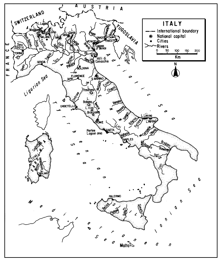
The Republic of Italy occupies a long boot-shaped peninsula extending south from the Alps into the Mediterranean. At its toe is the island of Sicily; to its west is the island of Sardinia.
Primarily mountainous or hilly, and lacking good forest and mineral resources, Italy is essentially a heavily populated agricultural, industrial and touristic country. Water resources, including a series of beautiful sub-Alpine lakes, are abundant in the continental north. Farther south, the few lakes are essentially of volcanic origin, and as the climate becomes increasingly Mediterranean the streams diminish to a few of torrential regime, being very low or even dry in summer. Brackishwater lagoons are characteristic of parts of the long coast.
Centuries of land and water use without environmental concern have diminished aquatic productivity, and great demands continue on the use of water for irrigation, production of hydroelectric power, and disposal of effluent wastes.
Commercial fishing in lakes persists, but is diminishing with eutrophication. Brackishwater lagoon fisheries continue, and commercial trout culture is very important. Sport fishing is in ascendancy, although only on a local level.
| 1. | AREA: | 301 268 km2 | |
| 2. | POPULATION: | 57 563 000 (est. 1990) | Density: 191 inh/km2 |
| 3. | PHYSICAL GEOGRAPHY | ||
Italy is situated in southern Europe between 35°30 and 47°5'30"N latitudes and 6°33' and 18°31'18"E longitudes.
Its greatest length is 1 225 km and its greatest breadth over 435 km although the lower or peninsular part does not exceed 240 km in width. Its altitudinal range is from slightly below sea level (in some polders) to 4 634 m. The highest peaks are in its continental part where the Alps have over 100 peaks exceeding 3 000 m; the peninsula has peaks over 2 900 m.
Italy is bounded on the northwest by France for 514 km, on the north by Switzerland for 744 km and Austria for 430 km, and on the east by Yugoslavia for 209 km1. It is bathed on the northwest by the Ligurian Sea, on the west by the Tyrrhenian Sea, on the east by the Adriatic Sea, and on the southeast by the Ionian Sea. Italy encloses two politically separate mini-states: Vatican City (the Holy See), an enclave of Rome with a boundary of 3.2 km and an area of 44 ha; and the hilltop Republic of San Marino with a boundary of 39 km and area of 61 km2.
1 The lengths of these boundaries are taken from Worldmark (1984)
Its total coast including its two major islands is 7 458 km in length; the islands have a coast of 4 016 km.
Essentially mountainous, plains (i.e., the area below 300 m) cover only 23 percent of the total area, hills 41 percent, and mountains (i.e., the area over 1 000 m) 36 percent.
Italy can be divided into two major sub-divisions: (i) Continental Italy in the north, and (ii) Peninsular Italy consisting of a mountainous backbone (the rugged Appennines) and coastal belts on either side. The two major islands, Sicily and Sardinia, can be considered as part of the peninsula or treated as insular Italy.
Another common division by geographers is to subdivide the entire country into four parts: North Italy, Central Italy, South Italy, and Insular Italy.
North Italy. This is bounded by the Alps which sweep across the country from the Riviera on the west and then north and east into Dalmatia. The highest peaks are in the west, the central Alps are less lofty but wider, and the eastern Alps (characterized by an abundance of limestone) are even lower. Many of the transverse valleys which break through (south) to the Northern Plain are blocked by vast terminal moraines which form the “Italian” or Lombard lakes.
South of the Alps and their foothills is the great Northern Plain which constitutes about 63 percent of the flatlands of Italy. The western part of the Plain is drained by the Po River system which continues east to the Adriatic Sea to form a low-lying lagoonal and deltaic coast of irregular outline. The eastern part is drained by several important rivers which flow independently into the sea through other lagoon and deltaic areas.
South of the Plain, the high rugged Appennines form the lower limits of North Italy and extend south as the backbone of Peninsular Italy.
Central Italy. This rather arbitrary division extends southwards to include the regions of Toscana, Umbria, Marche and Lazio1.
It is dominated by the Central Appennines, composed of several minor ranges and vast upland valleys. The mountains are bordered on each side by warmer and richer agricultural country extending to the seas.
Drainage on the Adriatic side is characterized by short rivers running straight to the sea. On the western side, the valleys of the Arno and Tiber or Tevere are dominant. The southern part of the Central area is in large part of volcanic origin forming hills containing crater lakes.
South Italy (the Mezzogiorno). The central mass of the Appennines continues south, bounded on the west by the plains of Campania and on the east by the plains and downs of Puglia - the largest such area on the peninsula. The extreme south continues to be mountainous, but is primarily granitic rather than limestone as in the northern part of the range. The extensively cultivated flatlands are characteristically “Mediterranean”. The rivers are generally unimportant.
Insular Italy. The two largest islands in the Mediterranean are Italy's Sicily and Sardinia. Sicily, lying only 3 km west of the toe of the mainland, has an area of 25 707 km2. It is essentially an area of mountains and plateaux, much of it porous limestone, similar to the mainland but lacking inland waters of consequence. Sardinia, an island of 24 092 km2 largely of granite plateau-like mountains, lies 220 km west of the mainland. Primarily pastoral, its mountain streams support trout and its lagoons contain brackishwater fish.
Italy also possesses a number of smaller islands lacking inland fisheries. The Tuscan Archipelago includes Elba (223 km2), Capraia and Gorgona. Islands in the Gulf of Naples are: Ischia (46 km2), Capri (10.3 km2) and Procida. Other islands are: the Aeolian Isles and the Aegades off Sicily, the Sardinian isles of Asinara, Maddalena and Caprera, and the Trémiti in the Adriatic.
With respect to geology, the folded and intensely glaciated Alps consist mainly of a core of crystalline rock plus shales, slate, and a limestone fringe. The depressed Northern Plain is primarily alluvial. The Appennines, mostly eroded sandstones, marl and clays in the north, become mostly limestone centrally and granitic in the extreme south. Volcanic activity is evident, especially in central Italy and the south where four active volcanoes (Vesuvius, Etna, Vulcano and Stromboli) persist. Italy has 711 glaciers, all of which lie in the Alps except for the Gran Sasso in the Appennines. Brown podsols and renzinas are common in the mountains. Brown Mediterranean soil, terra rossa, gravels, sands, shales and limestone are represented elsewhere. It is characteristic of Italy to have large areas of easily erodible rocks forming a basis for soil erosion, stream siltation and the formation of deltas and marshlands. Conversely, large areas of permeable rocks (limestone and tufa) have beneficial effects on the regime of some peninsular rivers.
The Central European and Mediterranean botanical regions overlap in Italy. Forests and brushwoods of coniferous and deciduous trees predominate in the north, while hard-leaved ever green trees, shrubs and conifers characterize the peninsula. In the Pre-Alps, and Alps, plants range from oaks and olives upward through beech, larch and spruce to an Alpine flora of dwarf plants. The flora of the great Po Valley is almost entirely introduced: poplars and the cultivated cereals. The Appennines support chestnuts, oaks and conifers. Coastal areas of central and southern Italy support olives, citrus fruits and eucalyptus as well as the xerophytic macchia, cacti and aloes of the south. Many of the forests have been degraded through centuries of war, erosion and use.
4. CLIMATE
The continental climate of northern Italy is a basic variation of the Central European type-biting cold in winter and torrid heat in summer. Peninsular Italy is so long, narrow and open to sea winds that much of it can be said to have a coastal climate, mostly “sub-Mediterranean” except in the mountains where it becomes more continental. Nevertheless, both seasonal and regional variations are great due to the country's 10° extent of latitude, its varied altitudes and the influence of sea and topography. Thus, the Northern Plain is often chilled by cold Alpine winds while climatic oases along the steep concave southern face of the Alps enable citrus fruits to flourish near the Lombard lakes and parts of Sicily are sub-tropical or “extra-Mediterranean”.
Without consideration of the high mountains, annual temperatures average about 12–14°C in the north, 15–17°C in central Italy and 17–18°C in the south. Winter temperatures are lowest in the high Alps but at lesser elevations are lowest on the Northern Plain. The warmest winter temperatures are found in Sicily where the January mean on the coast is 12°C. In summer, the hottest temperatures are found in the heel of Italy; the mean August temperature in Taranto is 25°C. Some extreme maxima are 39.2°C in Bologna, 44°C in Foggia and 49°C in Sicily.
The approximate average annual precipitation in Italy is 1 000 mm, but rainfall is highly influenced by the relief. The highest annual rainfall (sometimes to 2 000 or 3 000 mm) is found in the Alps; the lowest in the southern lowlands. In the north the tendency is toward spring and autumn maxima; and in the extreme north, winter is the driest period. Only in the southern peninsula is there a true Mediterranean regime of winter torrents and summer droughts, coupled with a hot wind, the sciracco.
Frost may occur throughout the country but is rare in the south. Permanent snow is limited to the Alps above the 2 700–3 000 m level but the Appennines may have snow for three or more months, and snow may persist on the Northern Plain for up to ten days. There is extended ice-cover only on the higher lakes and the Po rarely freezes.
Relative humidity is normally low, and some parts of Italy have a high evaporative rate. For example, only 30 percent of the precipitation in Sicily remains as stream runoff.
5. HYDROGRAPHY AND LIMNOLOGY
Table 5 indicates that the total inland water area of Italy is about 2.4 percent of the country's total area or 7 210 km2. The source of the table has not altered this percentage for at least 25 years. However, Italy/EIFAC (1974) states that the total area of Italy's inland waters (acque interne) is about 20 000 km2 or 6.6 percent of the country's area. Barring the possibility of reporting error, the large discrepancy may stem from the question of definition of “inland waters”. At first thought, one might think that the smaller estimate might include only fresh waters, while the larger one also included lagoons and other brackishwater areas. However, even if one adds up the following approximations based on the subsequent sections (lakes 2 045 km2, reservoirs - 500 km2 and lagoons -1 500 km2) one still derives a total of only 4 045 km2 1.
The average annual runoff from rainfall on Italian territory is 615 mm or 185 000 million m3. An addition of about 2 000 million m3m3 is received from upstream countries resulting in a total annual river discharge of 187 000 million m3 leaving the country (Van der Leeden, 1975 and ECE, 1978)1.
Overall, 69 percent of the water drains into the Adriatic, 21 percent into the Tyrrhenian Sea, 4 percent into the Ionian Sea, and 6 percent originates from Sicily and Sardinia.
5.1 Rivers (Fiumi)
All Italian rivers are subject to great variations in flow and it is only in northern Italy that most rivers have ample - if variable - supplies of water during the summer. On the peninsula, where snowfall is negligible, appreciable flows throughout the year are rare. The rivers are often torrential with floods during winter rains and - especially in the south - dry or almost dry during the hot summers. Thus, the Simeto in Sicily has varied from 1 081 m3 /second in flood to only 1 m3 /second at low water.
Broadly speaking, six main river regimes can be recognized:
Alpine rivers, which are influenced primarily by melting snows and glaciers which provide their maximum flow in early summer and minimum flow in December–February. Their summer floods are furthered by spring rainfall;
Sub-Alpine streams, including the lower courses of the main Alpine streams, have two periods of flood: one corresponding with the early Alpine flow and a less conspicuous one coming with late summer and autumn rainfall;
rivers flowing into the Po from the south have floods in March and November and low water from July to September;
the main Po has floods in May and November and low water in February and August;
in central Italy, the rivers reflect the rainfall regime of the region, i.e., high water in early spring, low water from July to September and a second high in November. Those with permeable basins have very little water during the summer;
in South Italy there is a typically Mediterranean regime. Drought is very marked in summer (even from May to October); many rivers dry up or merely trickle through wide pebbly beds. During the winter there are usually two short bursts of high water, one at the beginning and one at the end.
In addition to river regimes, note should be taken of the Italian springs (fontanili). In northern Italy, clayey impermeable beds force water to the surface in a line of springs extending clear across the Northern Plain. With good flows and temperatures ranging from 10 to 15°C, this has had important consequences for trout culture (see section 7.2).
As in several other European countries (see, for example, section 5.2 in the review of Belgium and France) attemps have been made in Italy to divide streams into various zones described by their predominant fish fauna. Studies in northern Italy by Sommani (1953) indicated that water temperature and flow were of more importance than gradient in determining the basic fauna.
Table 1 lists the principle rivers in Italy in order of their length as well as providing data on basin size and discharge.
De Angelis (1961) states that there are about 6 000 km of principal streams in Italy, but it may be noted that the 45 rivers listed in Table 1 have a combined length of 7 782 km.
Table 1
Principal rivers in Italy
| Rivers | Length km | Basin area km2 | Discharge in m3/second | ||
| Maximum | Minimum | Mean | |||
| Po | 672 | 69 382 | 7 000 | 214 | 1 720 |
| Adige | 410 | 14 700 | 2 500 | 100 | 220 |
| Tevere(Tiber) | 402 | 17 156 | 4 500 | 160 | 267 |
| Adda | 313 | 7 980 | 1 000 | 18 | 200 |
| Oglio | 280 | 6 640 | 425 | 36 | 137 |
| Tanaro | 276 | 7 985 | 1 700 | - | 123 |
| Arno | 248 | 8 443 | 2 000 | 15 | 100 |
| Ticino | 248 | 7 228 | 5 000 | 54 | 319 |
| Reno | 220 | 4 690 | 1 160 | 0.5 | 95 |
| Piave | 220 | 4 100 | 3 000 | 40 | 60 |
| Sarca-Mincio | 194 | 2 260 | 160 | 35 | 77 |
| Volturno | 175 | 5 680 | 2 000 | 32 | 70 |
| Brenta | 174 | 2 310 | 1 035 | 25 | 140 |
| Tagliamento | 170 | 2 590 | 1 500 | 50 | 80 |
| Liri-Garigliano | 168 | 5 020 | 1 340 | 25 | - |
| Ombrone | 166 | 4 200 | 1 975 | 2 | 90 |
| Panaro | 166 | 2 292 | 690 | 1 | 37 |
| Dora Baltea | 160 | 4 332 | 2 000 | 16 | 215 |
| Secchia | 157 | 1 250 | 790 | 4 | 42 |
| Aterno-Pescara | 152 | 3 130 | 2 790 | 18 | 42 |
| Taro | 150 | 2 083 | 1 200 | 0.5 | 42 |
| Tirso | 150 | 3 375 | 2 000 | - | 16.6 |
| Basento | 149 | 1 508 | 2 250 | 0.1 | 9.6 |
| Ofanto | 145 | 2 764 | 2 310 | 1.5 | 66 |
| Bradano | 140 | 2 735 | 2 000 | - | 10 |
| Sesia | 138 | 2 920 | 1 350 | 40 | 78 |
| Isonzo | 135 | 3 280 | 1 200 | 13 | 40 |
| Dora Riparia | 125 | 1 231 | 500 | 9 | 57 |
| Nera | 125 | 4 079 | 2 800 | 56 | 170 |
| Flumendosa | 122 | 1 782 | 2 230 | 0.2 | 16 |
| Sangro | 117 | 1 515 | - | 2.3 | 9 |
| Trebbia | 115 | 1 094 | 1 150 | 1.5 | 30 |
| Simeto | 115 | 1 832 | 1 850 | - | 16.7 |
| Bacchiglione | 113 | 1 600 | 770 | 38 | 78 |
| Serchio | 110 | 1 404 | 1 520 | 16 | 52 |
| Aniene | 99 | 1 415 | 480 | 16 | 32 |
| Sinni | 94 | 1 424 | 1 110 | 1 | - |
| Tronto | 93 | 1 192 | 1 325 | 2.4 | 20 |
| Fortore | 90 | 1 687 | 1 000 | - | 9.5 |
| Scrivia | 90 | 1 092 | 1 100 | 15 | 16 |
| Crati | 89 | 2 440 | 3 300 | - | 26 |
| Biferno | 85 | 1 311 | - | 1.5 | 11 |
| Trigno | 83 | 1 200 | - | 0.2 | 9 |
| Sele | 74 | 3 176 | 1 200 | 28 | 105 |
| Magra | 65 | 1 512 | 3 050 | 5 | 40 |
Source: Istituto della Enciclopedia Italiana, (1951), 19:728
North Italy. The dominant river of this area and also the largest river in Italy, draining one quarter of the country, is the 672-km Po River. Flowing as a mountain stream for 32 km and then meandering to its delta in the Adriatic Sea between Venice and Ravenna, it drains the western Italian Alps, the northern Appennines and most of the Northern Plain. The Po has abundant hydroelectric resources and en route to the sea it furnishes extensive irrigation to a broad cultivated valley.
Proceeding downstream, its major left bank (northern) tributaries are Alpine mountain streams: the Dora Riparia and Dora Baltea from the Val d'Aosta, Sesia, Ticino from Lake Maggiore, Adda from Lake Como, Oglio from Lake Iseo and the Mincio from Lake Garda. From the south, its major right bank affluents are the: Tanaro, Trebbia, Taro, Enzo, Secchia and Panaro.
At its mouth, the Po has a delta with subaerial area of 14 245 km2. With an average water discharge of about 1 700 m3/second, it discharges 67 million tons of sediment annually and its delta is growing at a rate of 26–61 m per year according to Shirley (1966) or 136 m per year according to Czaya (1981).
North of the Po, proceeding eastwardly, the main affluents to the Adriatic are the “Venetian” rivers. The most important of these is the 410-km Adige, with its two main tributaries the Isarco and Rienza, rising in a chain of Alpine lakes, flowing through the Alps for half its course and emerging on the plain above Verona. Four other important ones are the Brenta, Piave, Tagliamento and Isonzo.
South of the Po are a number of other rivers draining to the Adriatic and subject to spring floods: the Reno (formerly an affluent of the Po), Santerno, Lamone, Ronco and Marecchia.
Central Italy. The rivers of the peninsula follow the trend of the Appennines, draining either westerly to the Tyrrhenian Sea or easterly to the Adriatic.
On the west coast, as one proceeds southerly, the first major rivers are the Magra and its tributaries the Vara and Serchio entering the sea between La Spezia and Livorno. Next is Florence's river, the Arno, then the Ombrone, and then the Tiber (Tevere). The Tiber, with the second largest basin in Italy and third in length (402 km), flows generally south through Rome and to the sea to deposit 4–5 million m3 of silt annually. Minor snowmelt affects both the Arno and Tiber and flow from limestone zones keeps the Tiber alive in summer. Below the Tiber there are some small spring-fed streams in the Pontine area, cool enough for trout and blocked by coastal ridges to form marshes.
Draining from the Appennines into the Adriatic is a series of short rivers: the Foglia, Metauro, Esino, Musone, Potenza, Chienti and Tronto. Mostly torrential, those in limestone areas have a more regular regime.
South Italy. The major Tyrrehnian rivers, north to south, are: the Liri-Garigliano, Volturno and Sele. The Volturno constitutes the only important river in an area equivalent to two-fifths of the national area. The major Adriatic rivers, north to south, are: the Pescara, Sangro, Trigno, Biferno, Fortore, Candelaro and Ofanto. Rivers entering the Ionian Sea include the Bradano, Basento, Agri and Crati.
Insular Italy. Sicily has only a few perennial rivers of consequence: the Platani, Salso, Belice and Simeto. Most Sicilian streams are dry during the summer. In Sardinia, the major river is the 150-km Tirso flowing into the Gulf of Oristano where there are several lagoons. Other streams include the Coghinas, Posada, Flumendosa and two Mannus. They are used extensively for irrigation.
5.2 Lakes (Lago/Laghi)
Estimates of the number of lakes in Italy range from the 365 of Great Britain, Naval Intelligence Division (1944) to the 1 500 of Encyclopaedia Britannica (1974). Such discrepancies are probably a matter of definition.
De Angelis (1961) states that the area of Italian natural lakes over 5 km2 in area totals 124 859 ha. However, Table 2 Which shows the areas of 24 of the principal freshwater lakes of Italy shows a combined total area for these lakes of 1 216.4 km2 although half of them are under 5 km2 in area. (Since two of these lakes are shared with Switzerland, the actual Italian area of the ensemble is 1 143.1 km2.) Possibly De Angelis included some coastal “lakes” or brackish waters in his summation (see section 5.5).
Another more recent estimate of the total area of all of the lakes in Italy is 2.045 km2. This is derived from the statement of Ruggiu and Mosello (1984) that the area of the five greatest Lombard lakes totals 818 km2 and that the area amounts to 40 percent of the area of all the Italian lakes together1.
Table 2
Principal lakes of Italy
| Lake | Depth | |||||
| Altitude m | Area km2 | Maximum m | Mean m | Volume million m3 | ||
| Garda (Benàco) | 65 | 367.945 | 350.0 | 133.3 | 49 031 | |
| Maggiore (Verbano) | 194 | 212.510 | a | 370.0 | 177.5 | 37 502 |
| Como (Lario) | 198 | 145.910 | 410.0 | 154.0 | 22 500 | |
| Trasimeno | 258 | 124.290 | 6.3 | 4.7 | 586 | |
| Bolsena (Vulsinio) | 305 | 113.544 | 151.0 | 81.0 | 9 200 | |
| Iseo (Sebino) | 186 | 61.800 | 251.0 | 123.0 | 7 600 | |
| Bracciano (Sabatino) | 164 | 57.016 | 165.0 | 88.6 | 5 053 | |
| Lugano (Ceresio) | 271 | 48.846 | b | 288.0 | 130.0 | 5 540 |
| Orta (Cusio) | 290 | 18.150 | 143.0 | 71.6 | 1 300 | |
| Varese | 238 | 14.950 | 26.0 | 10.7 | 160 | |
| Vico (Cimino) | 507 | 12.080 | 48.5 | 21.6 | 260 | |
| Idro (Eridio) | 368 | 11.500 | 120.0 | 65.0 | 684 | |
| Pusiano | 259 | 4.933 | 24.3 | 14.0 | 69 | |
| Mezzola | 198 | 4.810 | 69.0 | 36.7 | 176 | |
| Oggiono | 224 | 3.810 | 11.3 | 6.3 | 24 | |
| Comabbio | 243 | 3.590 | 7.7 | 4.6 | 17 | |
| Monate | 266 | 2.510 | 34.0 | 18.1 | 45 | |
| Endine | 334 | 2.340 | 9.4 | 5.1 | 12 | |
| Mergozzo | 196 | 1.825 | 73.0 | 45.4 | 83 | |
| Annone | 224 | 1.703 | 10.1 | 4.0 | 7 | |
| Alserio | 260 | 1.228 | 8.1 | 5.3 | 7 | |
| Montorfano | 397 | 0.459 | 6.8 | 4.2 | 2 | |
| Segrino | 374 | 0.378 | 8.6 | 3.2 | 1 | |
| Pozzo di Riva | 198 | 0.263 | 11.2 | 5.6 | 1 | |
a Shared with Switzerland; Italian portion is about 170 km2 or 80 percent
b Shared with Switzerland; Italian portion is about 18 km2 or 37 percent
Source: Barbanti, Ambrosetti and Rolla (1981), except for mean depth of Lake Lugano and the Italian/Swiss areas taken from Istituto delle Enciclopedia Italiana, (1951), 19:729
The most common type of natural lake in Italy is the small (usually less than 50 ha) but deep, elevated Alpine lake occupying a rock basin hollowed out by recent glaciation. Among such lakes are: Caldonazzo, Molvena, Levico, Carezza and Santa Croce.
The largest and most spectacular of the Italian lakes, however, are the long, narrow, deep lakes of the Alpine foothills or pre-Alps, formed by Quarternary glaciers and dammed by moraines. These are the famous Lombard lakes, among the most beautiful lakes of Europe: Garda, Maggiore, Como, Iseo, Lugano, Orta and Idro.
A detailed description of the first five of these lakes will be found in Bonomi, Calderoni and Mosello (1979). These five oligomictic lakes exceed a volume of 120 km3 and contribute about one third of the Po's drainage. They are all becoming more eutrophic, their algal production controlled by phosphorus. Using the approach of OECD (1982) for a classification of their trophic status, they have been classified as follows: oligo-mesotrophic (Garda), meso-eutrophic (Maggiore), eutrophic (Iseo and Como) and eu-hypereutrophic (Lugano) by Ruggiu and Mosello (1984). All except Orta drain to the Northern Plain. Like many of the smaller glacial lakes these have been regulated to produce hydroelectric power.
A brief description, based mainly on Bonomi et al. (1970) and Gommes et al. (1981) of the second largest of these waters, Lake Maggiore, follows as indicative of their limnology, fisheries and other uses. With a drainage basin of 6 599 km2 in the Ticino (Po) system, Maggiore lies at an elevation of 194 m in a glaciated basin raised by a morainal dam. It has an area of 213 km2 (80 percent of it in Italy); a length of 66 km, width of 10 km, perimeter of 170 km and volume of 37.5 km3. It has a mean depth of 177.5 m and a maximum depth of 370 m in a crypto-depression. Chemically, it is now mesotrophic but in terms of P is oligotrophic. The mean pH is 7.4; the maximum 8.8. It has a conductivity of 137 u Scm-1. Its water residence time is 4.1 years. There is no ice-cover. The lake is used for waste discharge, flood control, water supply, boating, swimming and fishing and furnishes water for irrigation and rice paddies. Pelagic fishes represent the bulk of its biomass, but of four planktonic species, only two were native: the bleak (Alburnus alborella) and a landlocked shad, the agone (Alosa fallax lacustris).1 The other two are introduced: the pollan or lavarello (Coregonus lavaretus) from Lake Constance and the houting or bondella (C. oxyrhynchus) from Lake Neuchatel. Other species include trout, perch, pike, tench, chub and rudd. About 250 t of fish are taken annually (see sections 9.1 and 9.2).
1 This shad seems to have disappeared. See section 9.2
A third class of Italian lake is represented by those which are intervolcanic or lie in volcanic craters, e.g., Bolsena, Bracciano, Vico, Albano and Nemi in Central Italy and Averno near Naples. Varying in size, they are usually roughly circular, deep and without large inflowing streams.
A fourth class includes those dammed by landslides or alluvium. With the exception of the 124-km2 Lake Trasimeno in Umbria, which is partially tectonic, these generally shallow and irregular lakes are usually small in size. Many of them are held among the morainic hills at the mouths of Alpine valleys. The largest of these is Lake Varese (14.9 km2). Other examples are: Viverone, Monate, Comabbio, Pusiano and Annone in northern Italy and Alleghe, dammed by a landslide and partially tectonic.
A fifth class of Italian lake is limestone or karstic. Usually small and occupying irregular hollows, they often have underground drainage and variable water level. Examples are Lake Morto, Canterno, Matese, Circonia and Arsa.
A last class includes the coastal lakes (laghi costieri) similar to the brackishwater lagoons of the Adriatic (see section 5.5).
Most of the lakes provide fisheries for both cold and warm water species.
5.3 Reservoirs (Bacini artificiali)
Circa 1961, there were 30 000 ha of hydroelectric reservoirs and 1 500 ha of irrigation reservoirs in Italy according to De Angelis (1961). In addition to these there were thousands of small reservoirs. The total today far exceeds these figures but neither the size of nor the fish production from Italian reservoirs is as important as in a number of other European countries.
Italy has some very high dams. Of 252 “high dams” in Europe in 1962, Italy had 48 - a figure exceeded only by Spain. Among the major dams and reservoirs of the world listed by U.S. B.R. (1969), four are in Italy (see Table 3). Neither their storage capacity nor area is, however, large - thus lessening their value for fish production.
Table 3
Major dams in Italy (circa 1969)
| Dam | Drainage | Height (m) | Reservoir capacity (million m3) |
| Alpa Gera | Comori-Adda-Po | 178 | 65 000 |
| Place Moulin | Buthier-Dora Baltea | 155 | 100 000 |
| Santa Giustina | Noce-Adige | 153 | 183 000 |
| Speccheri | Leno di Vallarsa-Adige | 157 | 10 000 |
Source: U.S. B.R. (1969)
5.4 Canals (Canali)
De Angelis (1961) reports about 30 000 km of artificial canals and Framji and Mahajan (1969) say that there are 74 083 km of irrigation canals alone. Some of these, such as those which link rivers such as the Sesia, Ticino and Po to furnish irrigation water, also aid in the dissemination of fish. About 847 km of canal are navigable. Many of these canals provide sport fishing.
5.5 Lagoons (Lagune)
As used here (and in other sections of this review), the term “lagoon” (laguna in Italian) refers generally to a coastal body of water in permanent or intermittent connexion with the sea by either natural or artificial means. Often on deltas, they are mostly shallow, separated from the sea by beaches or dunes, at sea level or only slightly above, and sometimes with streams draining into them. Many mud-floored lagoons in Italy have developed behind the spots where silt from a river has precipitated upon contact with salt water. Thus, Adriatic lagoons are deltaic, alluvial formations originated by the appearance of a littoral strand, and successively filled and replaced by new lagoons nearer the sea and in progressive advance of a river's delta. The outer zones (lagune vive) are vivified by tidal waters; the inner parts of these lagoons have been completely cut off from the sea to become laguna morta or muddy dead shallows.
Owing to a mixture of fresh or limnetic water and marine water, these lagoons are brackish or mixohaline. Some, such as the lagoons of Fogliano and Monaci on the Tyrrhenian coast, were originally (mixo) oligohaline, i.e., of very low salinity, but following land reclamation which has lessened the incursion of fresh water, have reached a high degree of salinity, e.g., 26.5–45.5 ppt for Fogliano. Similarly, the littoral lagoons of the Northern Adriatic are for the most part prevailing (mixo) polyhaline or at least (mixo) mesohaline with oligohaline waters limited to areas near freshwater inlets. Variations in salinity are considered more important for the lagunal fauna than the content itself. Similarly, there are great variations in water temperature, e.g., some Tyrrhenian lagoons vary from 5° to 30°C throughout the year. Although the fauna of the Italian lagoons is somewhat impoverished in number of species as compared with the adjacent seas, they can be very productive - especially if aided by control of salinity and temperature and often by increase in anthropogenic enrichment.
Lagoons that have a connexion with the sea have mixed populations of brackish or euryhaline fishes. These generally enter the lagoon in the spring and attempt to return to the sea in autumn but European eels (Anguilla anguilla) may remain longer, and some lagoons with good freshwater sources may also support fish such as common carp (Cyprinus carpio). Salinities of 15–30 ppt and water temperatures from 18° to 25°C are generally favourable for the euryhaline and eurythermic species which enter the lagoons and form the bulk of their fisheries. (See section 7 for the fisheries of Italian lagoons, and section 5.4 in the review of Greece for further general information on lagoons.)
In Italy, a distinction is not always made between a lagoon and a coastal lake (lago costiero). Thus, De Angelis (1961) stated that lagoons with capture fisheries are termed laghi (lakes) on the mainland and stagni in Sardinia. Recently, Brambati (1985) pointed out that the difference between lagoons and stagni costieri is that lagoons are coastal bodies of water under the direct influence of tides, while stagni costieri are not influenced by tides. It should also be noted that although many Italian lagoons have been modified to facilitate entrance, outward migration and capture of fish, the primary lagoon fishery remains essentially a capture fishery. In Italy, it is really only on the northern Adriatic coast (near Venice) that considerable areas of brackish water have been modified by complex installations to control the exchange of water and facilitate the culture of brackishwater and euryhaline fish. These are known as valli da pesca (see section 7.2) and the term should be reserved for these specialized fish farms. Unfortunately, variations in terminology (such as terming free lagoons valli), natural hydrological changes, man-made changes such as drainage for agricultural development and lack of up-to-date statistics, make estimates of the present extent of Italian lagoons or even their status (such as suitability for or type of fisheries) difficult.
Table 4 is an attempt to show Italy's lagoon area as specified by various authors during the 1954–83 period. Judging from this table, there may have been about 147 000 ha of lagoons in Italy circa 1960 and about 62 000 ha today1. Some of the more prominent or best studied lagoons or lagoon-groups are listed below.
On the Tyrrhenian (western) side, proceeding from north to south, Ardizzone (1984) states that there are about 4 500 ha of coastal brackish waters used for fisheries and aquaculture between Orbetello and Gaeta: Orbetello (2 700 ha), Burano (140 ha) and the Pontine lakes (Fogliano, Monaci, Caprolace, Sabaudia, Fondi and Lungo) having a total area of 1 640 ha. For this same Tyrrhenian area, Panella, Della Seta and Hull (1982) list three lagoons in Toscana (Orbetello, Burano and Massaciuccoli) as comprising 3 650 ha, five lagoons in Lazio (Paola, Fogliano, Fondi, Caprolace and Monaci) totalling 1 600 ha, and five lagoons in Campania (Patria, Miseno, Fusaro, Lungo and Lucrino) totalling 400 ha.
Sardinian lagoons specifically mentioned by Kiener (1978) are: Cabras (2 000 ha) and Santa Gilla (2 150 ha). Cottiglia (1981) says that there are over 100 lagoons in Sardinia, totalling about 20 000 ha of which about 9 500 ha are used for fishing. He specifically mentions: Tortolli, Colostrai, Santa Giusta and Santa Gilla. Ravagnan (1981) mentions the following natural brackishwater “ponds” in Sardinia: Santa Gilla, Merceddi, Corru S'Ittiri, S'Ena Arrubbia, Santa Giusta, Cabras and Mistras, Calik, Tortolli, Colastrai, S. Teodoro, Casaraccio, Pilo and Cugnana. A comperhensive account of the lagoons in Sardinia is given in Consiglio Regionale della Sardegna (1981) according to Italy/EIFAC (1989). The author has not seen this account.
On the Adriatic side of the mainland there is an almost continuous series of lagoons, mostly open and tidal from Isonzo south to Venice. There is another series in the lower part of the Po delta, including the famous Comacchio. D'Ancona (1959) provided a summary of their limnological features at the time and grouped them from north to south as follows: Grado and Marano (12 717 ha), Caorle (1 696 ha including 1 596 ha of valli de pesca), Venice (54 889 ha) comprising three bodies of water in relation to the three mouths of (Lido, Malamocco and Chioggia), Caleri and Pozzattini (877 ha including some valli), Vallona (3 233 ha including valli), three valli, Ca' Zuliani, S. Carlo and Boccasette (873 ha), the lagoon of Sacca degli Sardovari (3 184 ha) plus some adjoining valli (2 200 ha), Mesola (3 200 ha), and Valli of Comacchio (29 000 ha). His list totals 111 869 ha and he stated that the total area of northern Adriatic lagoons is about 120 000 ha.
A more recent publication, Zerbinato (1981), has a detailed listing of the valli of the Northern Adriatic. It will be noted that the areas he specifies are, of course, far smaller than the totals of full lagoon area given by other authors. Proceeding from north to south along the Adriatic, he groups the valli as follows: Valli della Laguna di Marano-Grado (1 870 ha and 56 in number), Valli della Laguna di Caorle (1 703 ha and 5 in number), Valli della Laguna di Venezia (8 770 ha and 6 in number), Valli della Laguna di Caleri e dei Polesini Vecchia (7 890 ha and 16 in number) and Valli di Comacchio (10 800 ha); these are comprehensive of some different basins as Valle Campo, Vacca, Fossa di Porto, Fattibello.
Well to the south in Puglia are two brackishwater coastal lakes opening to the Adriatic: Lesina (5 136 ha) and Varano (6 500–7 000 ha).
Table 4
Estimated areas of lagoons in Italy (ha)
| Type | Tyrrhenian Sea | North Adriatic | South Adriatic | Sardinia | Sicily | Total | Source |
| Valli | - | 20 097 | - | - | - | - | D'Ancona (1954) |
| Lagoons, except North Adriatic (“valli”) | 4 300 | 50 000 | 12 200 | 11 000 | - | 77 500 | De Angelis (1961) |
| Lagoons | - | 120 000 | - | - | - | - | D'Ancona (1959) |
| Valli | - | 40 000 | - | - | - | - | Ravagnan (1972) |
| Lagoons, managed | 4 500 | 91 660+ | 12 160 | 16 000 | - | 135 000a | Kiener (1978) |
| Valli | - | 35 000 | - | - | - | - | Ravagnan (1981) |
| Lagoons | 4 400 | 100 450 | 12 200 | 8 400 | - | 125 450 | Amanieu & Lasserre (1981) |
| Lagoons and brackish waterb | - | - | - | - | - | 150 000 | Colombo (1981) |
| Lagoons | - | - | - | 10 000 | - | - | Cottiglia (1981) |
| Valli | - | 31 103 | - | - | - | - | Zerbinato (1981) |
| Lagoons and valli | 5 650 | 30 396 | 12 000 | 10 500 | 3 000 | 61 546 | Panella, Della Seta & Hull (1982) |
| Brackish culture | - | 40 000 | - | - | - | - | Brown (1983) |
| Lagoons | 4 500 | - | - | - | - | - | Ardizzone (1984) |
a Kiener's total of Italian lagoons “plus ou moins aménagées”
b Lagoons and brackish or salty water developed for aquaculture
There are also some small lagoons in Sicily with minimum importance with respect to fisheries production. Kiener (1978) mentions Marsala and Ganziri. Panella, Della Seta and Hull (1982) mention Stagnone di Marsala and Saline di Trapani.
In most of the lagoon areas, the principal activity is fishing followed by that of hunting.
6. LAND AND WATER USE
Table 5
Pattern of land use in Italy (1986)
| Percent | |
| Arable and permanent crops | 40.4 |
| Permanent pasture | 16.4 |
| Forests and woodlands | 22.3 |
| Other land | 18.4 |
| Inland water | 2.4 |
| Total | 100.0 |
Source: 1987 FAO Prod.Yearb., 41 (Publ. 1988)
Despite its bare hills, stony mountainsides and many unproductive plains, centuries of tillage and small-scale grazing have developed Italy as an agricultural country and it is still about 32 percent rural. Principal crops are cereals, potatoes, the vine, olives, fruit and early vegetables. On the whole, the size of the holdings is now small and calls for intensive cultivation to ensure subsistence. The use of chemical fertilizers is, relatively low, but is increasing.
Both drainage and irrigation have a long history in Italy and are widely practised today. For example, drainage of the 20-m deep Lake Fucino in central Italy was started in A.D. 52 but not completed until the late Nineteenth Century. Similarly, the drainage and canalization of the Pontine Marshes south of Rome which commenced in 312 B.C. was completed in this century. Drainage in Italy had several purposes: to gain ground for agriculture, prevent floods and improve water levels for rooting plants. It was also carried on to eliminate malaria, resulting in land reclamation to which irrigation was then carried.
Irrigation was known in Italy even before Roman times and important collective irrigation began in A.D. 1100–1200. In the south, it is a primary requirement of the agricultural economy, and is being extended to all parts of the country. By 1986, about 38 percent of the arable land was irrigated. A prime example is the tapping of the Sele River, a project carried on from 1906 to 1939, by the Apulian Aqueduct which conducts water from a Tyrrhenian Sea drainage about 250 km across the country to the slopes of the Adriatic.
Although Italy ranks about thirteenth in European roundwood production, the amount is not large and its forest industry is very limited. Most of the true forests are in the northern or Alpine regions and little natural forest remains. There has been almost uninterrupted deforestation since Etruscan times - a result not only of lumbering but of use for fuel, burning, over-grazing and violent rains causing erosion. Today, the watersheds are being improved through afforestation.
Italy's resource of basic industrial minerals is one of the poorest in Europe. Iron is largely lacking except in the northeast and on Elba, and coal is lacking except for some lignite in Sardinia. Bauxite, mercury, sulphur, salt, natural gas and oil are present in small quantities. Nevertheless, in spite of mining being only a minor industry, its destructive operations in some areas have greatly silted its streams, e.g., in Sardinia where the Piscinas and Navacauli rivers have been affected adversely.
Lack of coal stimulated the development of hydroelectric power in Italy. Starting in 185, it was almost its only source of power until 1945 and the country still relies heavily on its use. By 1966 there were over 2 700 hydro plants in Italy and by 1987, of a total installed, electrical capacity of 56 403 000 kW hydroelectric power represented about 32 percent (17 879 000 kW), nuclear power 2.3 percent (1 273 000 kW) and geo-thermal 0.9 percent. The remainder (36 745 000 kW) or 65 percent was thermal with most of the fuel being imported. There are very few large hydroelectric plants and most of these are in the Alps. Most plants are high head and use little water, sometimes collected from several streams. Some of the power originates from regulated natural lakes (e.g., the pre-Alpine lakes), some from artificial lakes with very high dams (see section 5.3). Storage in the Appennines is difficult because of torrential flows, but there are many medium-sized plants on most of its watercourses. In the south, many irrigation projects also provide electricity. A dense power grid extends throughout Italy; power is also imported from Austria and Switzerland.
Despite the lack of domestic raw materials and fuel, Italy has become one of the world's ten largest industrial powers. Emphasis is on engineering, auto and ship building, chemicals, metal-working, textiles and food processing. Despite concerted efforts by the Government to attract industry to the less developed Mezzogiorno, it remains concentrated in the northwestern industrial triangle of Turin-Milan-Genoa1. Industry is also spreading toward Venice-Mestre and other port cities such as Naples. There is a decided emphasis on state-owned or controlled industry and there is also a predominance of small establishments. The latter situation is in part responsible for wide-spread pollution of a minor nature.
The navigable river and canal system is primarily confined to the Northern Plain and northeast coastal area and lower reaches of the Arno and Tiber. There are 1 134 km of rivers and 847 km of canals, including a few locks, in the navigable waterway system. All of the larger pre-Alpine lakes and Lake Trasimeno are navigable throughout the year. Although the density of roads (about 1 km/km2 in 1988) is not high for western Europe, there is an excellent motorway (autostrada) system in Italy, a maze of minor roads and a railroad system of about 20 000 km (1985) to most parts of the country. About 1 out of 3 people had an automobile in 1985. Good harbours are few in number.
Ground water resources, estimated at about 20 000 million m3, are used for irrigation, domestic and industrial supply. Although this lessens the demand for surface waters, the latter are still used extensively for the same purposes.
Water pollution from industrial effluents has become very serious in Italy, especially in industrial areas far from the sea. The complex of effluents from sophisticated industries adds further to the problem. Metallurgical, chemical and electro-chemical industries, fertilizer plants and the processing of agricultural products are among the most important sources of polluting effluents. Sewage treatment is not generally practised in Italy, which adds to the problem of decreasing oxygen content of both rivers and lakes2. This lack of treatment is offset to some extent through land disposal.
2 No more than 150 of Italy's 8 000 cities and towns had sewage treatment plants circa 1977
Water use for irrigation, domestic water, industry, etc., was about 41 000 million m3 in 1969. In 1972, total water use in Italy was as follows: agriculture (61 percent), industry (21 percent), domestic (17 percent) and other uses (2 percent) according to ECE (1978). Considering the likely needs for water use by 2000 A.D., the demand for all types of water use may be expected to rise to 50 000 million m3 (Framji and Mahajan, 1969).
Both commercial and sport fishing are practised widely in the inland waters of Italy. Even small lakes often have commercial or subsistence fishing for fish such as coregonids. Extensive use has been made of brackishwater areas for both fisheries and salt production since Roman times and in some cases the demand for salt (an important tax item) has been given the greater priority. Trout culture has made rapid progress in recent years. The marine fishing industry in Italy is a minor industry but has a relatively high labour force. Fish imports are very high, being more than half of the total commercial fish supply in 1988. The per caput consumption had stabilized at about 9.5 kg/year by 1987 (OECD, 1989).
In this country of great scenic beauty with countless centres of significance in both art and history, tourism is a most important industry - being the mainstay of its balance of payments position. Over 53.6 million tourists visited Italy in 1986 but sport fishing was not an important factor in their attraction.
7. FISH AND FISHERIES
There are about 56 species of freshwater and diadromous fishes in the inland waters of Italy as well as some euryhaline species. About 45 are freshwater species.
Among the commonest native species of economic importance are: the European eel (Anguilla anguilla), brown trout (Salmo trutta), barbel (Barbus barbus), chub (Leuciscus cephalus), roach (Rutilus sp.), rudd (Scardinius erythropthalmus), tench (Tinca tinca), and the euryhaline species called latterino (Atherina boyeri). Of lesser importance among the native fishes are: three species of now rare sturgeons (Acipenser and Huso), char (Salvelinus alpinus), grayling (Thymallus thymallus), pike (Esox lucius), burbot (Lota lota), and European perch (Perca fluviatilis).
Italy has a considerable number of introduced fishes in its inland waters. Among the most important of these are: rainbow trout (Oncorhynchus mykiss), pollan (Coregonus lavaretus), common carp (Cyprinus carpio), goldfish (Carassius auratus), North American bullheads or catfishes (Ictalurus melas, I. nebulosus and I. lacustris), mosquitofish (Gambusia affinis), pumpkinseed (Lepomis gibbosus), and largemouth black bass (Micropterus salmoides). Less abundant among the exotics are the American brook trout (Salvelinus fontinalis), grass carp (Ctenopharyngodon idella), European catfish (Silurus glanis), pike-perch (Stizostedion lucioperca), and silversides (Odontesthes honar).
The shads (Alosa alosa and A. fallax) frequent the Italian seas and enter the rivers and a subspecies, the agone (A. f. lacustris), is landlocked in some of the northern Italian lakes (e.g., Como) where it furnishes both food and sport. In addition to these, grey mullets (Mugil spp.), the European eel, the gilthead (Sparus auratus), sea bass (Dicentrarchus labrax), sole (Solea vulgaris) and the flounder (Pleuronectes flesus) enter lagoon waters seasonally to remain for one or more years during a period of nutrition and growth, and returning to the sea with the onset of sexual maturity.1 A number of other euryhaline fishes also enter lagoons to feed during the spring and summer.
It is of particular interest that some of the most utilized fishes (rainbow trout and coregonids) have been introduced.
In addition to the finfishes, Italy has two native species of crayfish: Astacus astacus with a marginal distribution in the northeast and the move widespread Austropotamobius pallipes. Astacus leptodactylus has been imported from Turkey, and Procambarus clarkii from Kenya and Spain.
7.1 Capture Fisheries
7.1.1 Commercial fishing
Commercial fishing in Italy is confined to some lakes and reservoirs and to a few reaches of the larger rivers.
Table 6 shows the commercial “catch” in the inland waters of Italy during the 1965–87 period as reported to FAO by Italy. During the 1965–69 period, the “catches” of common carp and trout were apparently lumped with those of other freshwater fishes. It is certain that the “catches” of trout in this table are mostly cultivated fish; of Table 6 with Tables 11 and 12. Italy's catch of European eels and mullet in the Mediterranean during the period of 1965–87 as recorded by FAO is shown in Table 7. It can be noted that other sources recording the catch of these euryhaline fishes differ. For example, the 1979 mullet catch in the sea is recorded as only 4 800 t by Panella, Della Seta and Hull (1982) as against FAO's 6 406 t.
Table 6
Nominal catches by species in the inland waters of Italy, 1965–87a
(in tons)
| Common carp | Freshwater fishes | European eel | Trouts | Total | ||
| Year | (Cyprinus carpio) | n.e.i. | (Anguilla anguilla) | (Salmo sp.) | ||
| 1965 | - | 15 100 | 2 700 | - | 17 800 | |
| 1966 | - | 16 300 | 2 600 | - | 18 900 | |
| 1967 | - | 16 800 | 2 600 | - | 19 400 | |
| 1968 | - | 17 300 | 2 700 | b | - | 20 000 |
| 1969 | - | 17 700 | 3 000 | b | - | 20 700 |
| 1970 | 3 000 | 5 000 | 1 000 | 8 500 | 17 500 | |
| 1971 | 3 000 | 4 700 | 1 000 | 8 500 | 17 200 | |
| 1972 | 3 600 | 4 000 | 600 | 8 800 | 17 000 | |
| 1973 | 3 200 | 4 900 | 600 | 8 700 | 17 400 | |
| 1974 | 3 110 | 4 565 | 639 | 9 436 | 17 750 | |
| 1975 | 3 012 | 4 312 | 663 | 11 113 | 19 100 | |
| 1976 | 2 747 | 3 991 | 576 | 14 066 | 21 300 | |
| 1977 | 2 962 | 3 931 | 592 | 15 415 | 22 900 | |
| 1978 | 2 997 | 4 046 | 555 | 17 012 | 24 610 | |
| 1979 | 3 374 | 4 477 | 665 | 19 714 | 28 230 | |
| 1980 | 3 234 | 6 380 | 543 | 25 000 | 34 460 | |
| 1981 | 3 011 | 5 256 | 530 | 28 000 | 36 797 | |
| 1982 | 2 944 | 4 922 | 494 | 31 400 | 39 760 | |
| 1983 | 3 095 | 5 266 | 449 | 32 500 | 41 310 | |
| 1984 | 3 240 | 4 863 | 2 500 | 35 750 | 46 353 | |
| 1985 | 2 973 | 5 046 | 2 500 | 33 000 | 43 519 | |
| 1986 | 2 902 | 5 035 | 2 500 | 35 500 | 45 937 | |
| 1987 | 3 331 | 5 822 | 2 000 | 39 050 | 50 203 | |
(-) = This category not listed this year
b = Estimated or calculated by FAO
Source: 1965–69 - Yearb.Fish.Stat.FAO, 36 (Publ. 1974)
1970–83 - FAO Fish.Dept.Fishery Statistical Database (FISHDAB)
1984–87 - Yearb.Fish.Stat.FAO, 64 (Publ. 1989)
Table 7
Norminal catches of European eel and mullets in Marine Statistical Fishing Area 37 (Mediterranean) by Italy, 1965–87 (in tons)
| Year | European eel (Anguilla anguilla) | Mullets (Mugilidae) |
| 1965 | 500 | 5 200 |
| 1966 | 500 | 5 900 |
| 1967 | 500 | 6 300 |
| 1968 | 500 | 6 300 |
| 1969 | 400 | 6 500 |
| 1970 | 2 300 | 7 200 |
| 1971 | 2 400 | 7 500 |
| 1972 | 2 300 | 7 200 |
| 1973 | 2 300 | 7 400 |
| 1974 | 2 058 | 7 030 |
| 1975 | 2 310 | 7 210 |
| 1976 | 2 101 | 6 991 |
| 1977 | 1 870 | 7 626 |
| 1978 | 1 682 | 6 330 |
| 1979 | 1 757 | 6 406 |
| 1980 | 1 721 | 6 412 |
| 1981 | 1 810 | 7 662 |
| 1982 | 1 593 | 6 900 |
| 1983 | 1 627 | 6 697 |
| 1984 | 2 000 | 6 160 |
| 1985 | 2 000 | 6 668 |
| 1986 | 2 000 | 6 340 |
| 1987 | 1 500 | 7 226 |
Source: 1965–69 - Yearb.Fish.Stat.FAO, 36 (Publ. 1974)
1970–83 - FAO Fish.Dept.Fishery Statistical Database (FISHDAB)
1984–87 - Yearb.Fish.Stat.FAO, 64 (Publ. 1989)
Another table (Table 8) derived directly from the Italian Government's own statistical yearbook distinguishes the fish caught in lakes and reservoirs from those caught in marine and lagoon areas but does not distinguish lagoon-caught fish from ocean-caught fish1. It does show, however, that during the years of record (1975–85) the strictly inland fish catch varied only from 1.8 to 2.6 percent of the total Italian catch of finfish, molluscs and crustaceans or 2.5 to 3.4 percent of the total Italian catch of finfish alone.
A fourth table (Table 9) illustrates the fish catch in 1980 and 1985 from lakes and reservoirs in the four major geographical areas of Italy. The importance of the Lombard lakes in contributing to this catch is emphasized by noting that the original sources shows that the Region of Lombardia furnished about one-third (3 178.1 t and 2 911.8 t) of the total catch in both years, and the neighbouring region of Piemonte furnished 12.5 percent (1 186.8 t) in 1980 and 8.4 percent (703.9 t) in 1985.2
Table 8
Italian fish production 1975–85 (in tons)
| Year | Marine and lagoon fish | Fish from lakes and reservoirs | Grand total | ||
| Fish | Molluscs and Crustaceans | Total | |||
| 1975 | 257 360 | 109 220 | 366 580 | 9 100 | 375 680 |
| 1976 | 266 113 | 112 461 | 378 574 | 8 300 | 386 874 |
| 1977 | 250 975 | 87 019 | 337 994 | 8 500 | 346 494 |
| 1978 | 286 626 | 71 233 | 357 859 | 8 710 | 366 569 |
| 1979 | 296 770 | 82 912 | 379 682 | 10 030 | 389 712 |
| 1980 | 286 295 | 105 574 | 391 869 | 9 459 | 401 328 |
| 1981 | 289 969 | 102 292 | 392 261 | 8 797 | 401 058 |
| 1982 | 300 556 | 115 176 | 415 732 | 8 360 | 424 092 |
| 1983 | 290 499 | 124 206 | 414 705 | 8 810 | 423 515 |
| 1984 | 300 418 | 128 272 | 428 690 | 8 055 | 436 745 |
| 1985 | 305 130 | 125 505 | 430 635 | 8 301 | 438 936 |
Source: 1975–78 - Istituto Centrale di Statistica (1980)
1979–81 - Istituto Centrale di Statistica (1982)
1982–85 - Istituto Centrale di Statistica (1987)
Table 9
Italian fish production in lakes and reservoirs, 1980 and 1985
| Geographic area | 1980 | 1985 | ||
| Tons | Percent | Tons | Percent | |
| North Italy | 6 649.4 | 70.3 | 5 594.2 | 67.4 |
| Central Italy | 2 501.2 | 26.5 | 2 334.5 | 28.1 |
| South Italy | 199.2 | 2.1 | 348.1 | 4.3 |
| Insular Italy | 109.4 | 1.1 | 24.6 | 0.3 |
| 9 459.2 | 100.0 | 8 301.4 | 100.0 | |
Source: Istituto Centrale di Statistica (1981, 1987)
Despite the existence of these “official” tables of fish “catch” or “production” in Italy, it is difficult to determine their exact species composition, those fishes taken by capture and those which are cultivated, those taken from brackish waters. As an aid toward such determinations, one must examine other sources.
About 50 years ago, Italia (1931) stated that there were 22 major lakes and 49 minor lakes in Italy with commercial fisheries. Of these lakes, seven were reported to have produced a total of 3 663 t in 1929. The fishes then dominating this lake catch were: coregonids, carp, tench, bleak, chub, landlocked shad, perch, eel and catfish. Neither rivers, canals, nor reservoirs were mentioned as having commercial fisheries.
Circa 1958, rough estimates by De Angelis (1961) indicated that the catches in Italian fresh waters totalled 8 000 t; 3 600 t (45 percent) from lakes and 4 400 t (55 percent) from rivers and canals. These statistics were considered to include the catch by both commercial and sport fishermen. It is the author's belief that the reported fluvial catch was primarily that by sport fishermen and that under any circumstances it was a highly speculative estimate.
Circa 1986, another De Angelis (1986) stated that the number of Italian lakes employed in fisheries are about 150, of which 107 have an area larger than 20 ha. He also stated that production (i.e., catch) was about 10 000 t annually, and that about three-quarters of this came from the 17 main lakes of North and Central Italy with a total area of about 1 169 km2.
Table 10 is a breakdown of the catch in Italian lakes and artificial basins in 1972. Of this total (although partial) catch, about 82 percent (3 594.4 t) was taken commercially and about 18 percent (815.4 t) by sport fishermen.
A final table (Table 11) represents another breakdown of the commercial catch in Italian lakes, data for 1979 derived originally from the Istituto Centrale di Statistica. It may be noted that the percentages of the various species groups does not vary markedly from those shown for the 1972 catch (Table 10).
Both De Angelis (1986) and Ministero dell'Agricultura e Foreste (1988) state that an estimated Italian inland water catch of 10 000 t annually is composed about as follows: 50 percent eel, pike and perch; 35 percent cyprinids, and 15 percent trouts (rainbow and brown) and coregonids.
The catch in brackish water will be discussed in section 7.2 as it is difficult to distinguish capture fishery catch from valli culture.
7.1.2 Sport fishing
As in other European countries, sport fishing in Italian inland waters is becoming more important. In 1929, there were only 50 672 sport fishermen (Italia, 1931) or about 0.12 percent of the total population. Circa 1973, there were about 850 000 sport fishermen or 1.6 percent of the total population; in 1987 there were about 2 000 000 sport fishermen or 3.5 percent of the total population.
Most of the fish taken commercially are also taken for sport: several cyprinids, pike, perch, eel and trout, for example. Although wild fish constitute the bulk of the catches, many Italian fishing clubs now stock private ponds or sections of stream with hatchery-reared fish, especially rainbow trout, for a catchable programme. The introduced large mouth black bass is also popular, being widespread throughout Italy.
Italy's waters lack the appeal to the foreign angler possessed by countries like Norway, but do have two sub-species of brown trout whose scarcity in Europe has attraction for some anglers. These are the trota padana or marble trout (Salmo trutta marmoratus), found in the Alpine waters of the Po drainage as well as in Yugoslavia and trota sarda or macrostigma (S. t. macrostigma) also resident in Turkey and North Africa.
Sport fishing methods run the gamut from the use of lift nets from city bridges and heavy groundbaiting in canals to flyfishing for trout, grayling and cavedano (Leuciscus cephalus).
7.2 Aquaculture and Brackishwater Fisheries
Formerly noted for its brackishwater aquaculture, Italy has now become a major producer of cultivated rainbow trout and is expanding into other areas. De Angelis (1961) stated that the annual yield in Italy from aquaculture was 9 350 t: 1 200 t of trout and 8 150 t of brackishwater species. During the next 30 years, trout production reached over 30 000 t annually, while brackishwater production lessened to perhaps 6 000 t annually.
As in other Mediterranean countries, there are difficulties in obtaining information on aquacultural production in Italy: lumping of statistics from capture fisheries and aquaculture, the sometimes thin line between “extensive aquaculture” and capture fisheries and unclear expression by reporting authors. Because of such difficulties - particularly with respect to the catch/production in brackish water, the fisheries in Italy's lagoons, whether capture or culture, are discussed in this section. It should be understood that some of the material that follows might just as well as have been presented in section 7.1.1.
Table 10
Partial catches in Italian lakes and reservoirs, 1972
| Species | Tons | Percent |
| Cyprinids | 1 571.9 | 36.0 |
| Pike and perch | 714.0 | 16.0 |
| European eel | 344.2 | 7.8 |
| Salmonids | 422.7 | 10.0 |
| Other fishes | 1 337.0 | 32.0 |
| Total | 4 409.8 | 100.0 |
Source: EIFAC (1974)
Table 11
Catches in Italian lakes and reservoirs, 1979
| Species | Tons | Percent |
| Carp, tench, bleak | 3 400 | 34 |
| Trout, char, coregonidsa | 1 500 | 15 |
| Pike, perch | 1 200 | 12 |
| European eel | 700 | 7 |
| Other fishes | 3 200 | 32 |
| Total | 10 000 | 100 |
Source: Panella, Della Seta and Hull (1982)
The more traditional culture of brackishwater species in Italy originated centuries ago, possibly with the Etruscans, certainly carried on by the ancient Romans, and known to be flourishing in areas like Comacchio in the Fourteenth Century. Not all of this can be called “aquaculture” sensu strictu, and in any case it is usually quite an extensive method. Some of it is derived from a modified capture or trap fishery where fish from the Mediterranean migrate naturally into a coastal lagoon during the spring and are then captured as they attempt to return to the sea in the autumn. A more sophisticated version of lagoon “culture” is the Italian system of valli culture or vallicultura found principally on the northwestern Adriatic coast from Grado south to Comacchio. In this system fish are held in embanked or fenced lagoons or fish farms called valli da pesca, which are subject to a considerable control of water levels, salinity and temperature. There are three general types of valli: (i) valli aperti (open), which are only enclosed temporarily with trellis or screens; (ii) semi-arginate or partly enclosed, which admit the flow of the tide and young fish but keep in the larger ones, and (iii) valli arginate, which are completely surrounded by earth and stone, except for carefully controlled channels to the sea. Depth in such culture lagoons is about 0.7–1 m, the salinity usually ranges from 10 to 30 ppt, and the water temperature from near freezing to more than 30°F. In the most elaborate valli there is control of freshwater and sea water (which may involve pumping), drainage channels, sluice gates, fish weirs and trenches to protect the fish from winter cold. Another method to protect the deeper salt water from cooling is to admit fresh river water which forms a thin sheet of ice over the lagoon.
The primarily brackishwater species reared in lagoons are: the grey mullets (Mugil capita, M.auratus, M. saliens, M. chelo and M. cephalus), European eel, gilthead, sea bass, flounder and sole1. Atherina is also caught in lagoons. These euryhaline fishes often migrate toward freshwater or brackish waters as young, and - unless restrained by closure of the outlet - move outwardly to the sea later in the year to breed or avoid cold water in the lagoon. Some fish raised in valli enter naturally from the sea, or they may be collected from other areas and stocked as fry or juveniles. Eels, for example, which stay in for some years, are often brought to the northwestern Adriatic lagoons from the Tyrrhenian coast where they are collected at barriers to streams, e.g., at outlets near power stations near Rome, or even transported here from the Atlantic coast of France. Under-sized fish may be held over winter in deep trenches with supplemental feeding and retained to grow for a second summer. Although lagoon fish may be taken in trammel nets, gillnets and seines or fykes (especially for eels), the more complex valli use fixed systems for capture. These are weirs constructed of concrete with metal screens. Called lavorieri, they capture the fish as they attempt to migrate to the sea when the channels are opened. The aquacultural production of mullets in Italy was estimated by FAO Fish.Info.Data and Stat.Serv. (1989) to be 3 200 t in 1984, 3 200 t (1985), 5 200 t (1986) and 3 500 t (1987).
Some of the brackish water forms are now also cultivated more intensely in Italy. For example, the sea bass has been reared in Sicily since 1979 (SIME, 1984). According to Ravagnan (1984), under extensive culture and under the climatic conditions of Venice, sea bass attain a commercial size of 350 g in 30 months and one of 350–400 g in 21 months when cultivated intensively in earthern or concrete ponds. He also states that the productivity of sea bass in a valli is 10–20 kg/ha/g. Gilthead are raised in valliculture exclusively under extensive conditions producing about 15–30 kg/ha/year. According to FAO Fish.Info.Data and Stat.Serv. (1989), about 250 kg of sea bass and 250 kg of gilthead were raised each year during the 1984–87 period.
Total yields from valli seem to range from about 100–200 kg/ha/year, as do the yields from some of the best lagoon fisheries. D'Ancona (1954) listed the mean annual production from Venetian valli (circa 1953) as 150 kg/ha/year and gave another estimate of this production as 140 kg/ha/year. About 20 years later, Ravagnan (1972) stated that the yield from a well managed extensive fenced lagoon should be about 150/kg/ha annually.
The aquacultural production of brackishwater fishes (pesce di valle) in 1973 was reported to be 4 000 t (Italy/EIFAC, 1974). Based on an assumed production of 150 kg/ha/year and a water area of 40 000 ha, Brown (1977, 1983) estimated the total annual brackishwater production in Italy to be about 6 000 t which he believed was divided about equally between mullets, eel, gilthead and sea bass. The ADCP (1979) estimated the annual finfish production in Italy from “traditional lagoon and valli culture” to be about: 2 200 t of mullet, 1 100 t of eel, 1 100 t of gilthead, 550 t of sea bass and 300 t of sole. This total estimate of 5 250 t annually is somewhat less than that of Brown (op cit.) and that of Panella, Della Seta and Hull (1982), who estimated a commercial production of consumable fish from Italian lagoons and valli of 5 700 t in 1979, composed as follows: 2 000 t of eel, 3 200 t of mullet and 500 t of gilthead and other species.
According to Brown (1977, 1983), these major brackishwater fish are generally sold at the following sizes and ages: mullet and sea bass, 300–1 000 g (3–5 years); gilthead, 150–400 g (1–2 years); silver eels, 400 g (7–9 years).
Not only are eels reared extensively in brackish waters in Italy, they are raised intensively in fresh water, with elvers stocked in concrete tanks with circulating water and fed artificially for about three growing seasons to attain a size of 200–300 g. Warm water is also being tried, using both thermal effluent and geothermal wells. De Angelis (1986) states that intensive production of eels in Italy is about 2 500 t annually, while the extensive production of eels in brackish water amounts to about 2 000 t annually. Another source (FAO Fish.Info.Data and Stat.Serv., 1989) says that the aquacultural production of eels in Italy ranged from 1 800 t in 1984 to 3 500 t in 1987 during this period.
The primary aquacultural production in Italy today, however, is that of portion size rainbow trout, perhaps the highest production in Europe. Originally, it took about two years to raise trout in Italian mountain water but most of the production today is in continental Italy just south of the Alps, where abundant spring water of good temperature (12–13°C) exists. Another major area is on the east coast near Pescara. Well water of 12°C is also used. Use of these sources rather than surface water (as is used in Denmark) has greatly lessened the chances of fish disease. Use of raceways, artificial feeds and other modern methods has likewise improved Italian trout production.
In 1961, Italian commercial production of rainbow trout was only 1 200 t, but following the use of spring water and new methods, production in 1968 was ten times greater, 12 000 t. Ten years later (1978) it was almost 18 000 t annually. In 1989 Italian production of portion-sized trout was 31 000 t and 1 000 t of large trout were also raised (FES, 1989). See Table 12, which lists the production from 1968 to 1989 according to various sources.
Market size is about 200–250 g. Exports have risen steadily; the major export markets are France, the Federal Republic Germany and Belgium. Sales of domestic trout have been about evenly divided between wholesalers and other outlets, with about 40 percent of the latter going to fish-out ponds.
FES statistics show Italy as also rearing 300 t of salmon in 1988 and increasing this amount to 500 t in 1989 (FES, 1986; 1989). FAO Fish.Info.Data and Stat.Serv. (1989) estimates an aquacultural production of common carp in Italy during 1984–87 period ranging from 800 t (1985, 1986) to only 500 t in 1987.
Cypriniculture was introduced into Italy at the end of the Nineteenth Century in areas in the Po Valley, where permanent rice fields and large canals already held fish populations. In addition to common carp, the goldfish and tench were used. The crop consisted of fingerlings and adults up to about four years of age, and average annual yields of 100 kg/ha/year were reported (Chiapelli, 1938). This ricefield culture increased for about 40 years and then declined to a point where it is no longer of importance in Italy. Changes in agricultural practices, including the use of weedicides and pesticides, were among the reasons for its decline. The practice persists today but only on a small scale, with some of the fish being sold to pond owners and fisherman clubs and with Italy importing some carp and tench from other countries. Brown (1983) estimated that the total production from rice fields in Italy would be less than 5 t annually. See also: Tonolli (1955), Coche (1967) and Vincke (1979). Panella, Della Seta and Hull (1982) estimated that in 1979, 500 t of carp were cultivated in Italy, a figure corroborated by De Angelis (1986) for annual production circa 1985.
The American bullheads or catfish have long been regarded as pests in Europe, both in open waters and in carp and tench ponds, and trade in live brown bullheads (Ictalurus nebulosus) is forbidden by law in Italy. Nevertheless, the black bullhead (I.melas) is now being produced in some quantity in Italy. In 1971, about 100 t were produced (Brown, 1977, 1983), which increased to about 1 200 t by 1979 (Ghittino, 1979, and Panella, Della Seta and Hull, 1982), and to about 1 900 t circa 1985 (De Angelis, 1986).1 FAO Fish.Info.Data and Stat.Serv. (1989) records an annual aquacultural production of the black bullhead in Italy of 1 500 t during the 1984–87 period.
1 Italy/EIFAC (1974) stated that 500 t of carp and catfish were produced in Italy in 1973
The Chinese grass carp (Ctenopharyngodon idella) has recently been introduced into Italy for fish culture.
According to De Angelis (1986) there are about 500 fish farms with a total area of about 1 500 ha. Their distribution between fish species is unknown.
8. OWNERSHIP, ADMINISTRATION, MANAGEMENT, INVESTIGATION AND AGREEMENTS1
8.1 Ownership and Rights
Public waters are or may be defined by Italian law but there is no definition of “private waters” - hence no such concept is deemed to exist. Rivers, torrents, springs, lakes and extracted ground waters are deemed “public waters” whenever they are or may become fit to satisfy public needs. They are part of the State's Public Domain. Waters other than public waters are termed “non-public waters”, are subject to rights of use exclusively, and are subject to doctrinal and jurisprudential controversies. The right to use non-public waters includes that of fishing and can involve exclusive fishing rights.
With respect to fishing rights in Italy, one can recognize:
Exclusive fisheries rights: These are reserved for certain ancient properties recognized by the State under special laws. These primarily concern several zones of lakes and brackishwater ponds.
Public domain fisheries reservations: These are ancient estate properties which have been confiscated by the State and opened every six years to public bidding for fishing rights. They are mostly trout streams in northern Italy.
Concessions for fish culture: These are temporary fisheries reservations (for a maximum of 15 years). In order to use them, the concessionnaires are obliged to meet certain requirements, e.g., restocking or construction of works that facilitate fish production. Fish breeding in rice fields is subject to yearly authorization. The provincial administrations have the authority to grant these concessions.
8.2 Administration
The Ministry of Agriculture and Forestry, through its Agricultural Production Office, has overall responsibility on a national level for fisheries in inland waters and a central institute of research for hydrobiology and fisheries.
8.3 Management
8.3.1 At present, this Ministry prepares the framework of laws for fishing in inland waters but administrative functions concerning this fishing are delegated to the (20) Regions of Italy.
8.3.2 Within the Regions, the responsibilities for executive and regulatory functions for inland fisheries are carried out by the individual (94) Provinces. They also issue fishing licences and award concessions for fish culture.
8.3.3 Rules and regulations: The Fisheries Code is a compilation of regulations under two headings:
Regulations governing fisheries: organization of fishery services; registered documents and fishing licences; supervision; penalties and judgements, and
Regulations governing assistance for fisheries and fishermen: tax and other exemptions; fisheries cooperatives and consortia; associations for the protection and promotion of fisheries for public benefit; vocational training; research, surveys and publications; insurance; marketing regulations, etc.
8.3.4 Licensing: There are four types of licences, all issued by the provincial administrations: (i) Type A for fishing with all types of gear for professional fishermen only; (ii) Type B for fishing with a simple rod or small square net with sides not exceeding 1.5 m; (iii) Type C for fishing with simple rods and small square nets, and (iv) Type D for foreign licences entitling the holder to the same rights as holders of the Type B licence.
Table 12
Estimated production of cultivated trout in Italy, 1968–89
(in tons)
| Brown (1983)a | Zerbinato (1981) | Giorgetti & Ceschia (1982) | Lewis (1981)b | Panella, Della Seta & Hull (1982) | Shaw, Shaw & Thomas (1981)c | Fish Farming Int., 9(10) (1982) | Fish Farming Int., 11(6) (1984) | Italy/EIFAC (1989) | FAO Fish. Info.Data Serv. (1989) | FES (1986, (1989) | |
| 1968 | 12 000 | - | - | - | - | - | - | - | - | - | - |
| 1969 | 13 000 | - | - | - | - | - | - | - | - | - | - |
| 1970 | 13 500 | 12 000 | - | - | - | - | - | - | - | - | - |
| 1971 | 14 000 | 13 000 | - | - | - | - | - | - | - | - | - |
| 1972 | 15 500 | 15 500 | - | - | - | - | - | - | - | - | - |
| 1973 | 15 000 | 15 000 | - | - | - | - | - | - | - | - | - |
| 1974 | 16 430 | 16 450 | 16 430 | - | - | - | - | - | - | - | - |
| 1975 | 16 120 | 16 100 | 16 120 | - | - | - | - | - | - | - | - |
| 1976 | 17 000 | 17 000 | 17 000 | - | - | 17 000 | - | - | - | - | - |
| 1977 | 17 250 | 17 250 | 17 250 | - | - | 17 000 | - | - | - | - | - |
| 1978 | 19 900 | 17 850 | 18 000 | 17 840 | - | 17 840 | 17 840 | - | - | - | - |
| 1979 | 19 900 | 19 900 | - | 18 000 | 20 000 | 18 000 | 19 900 | - | - | - | - |
| 1980 | - | 20 500 | - | - | - | 20 400 | 19 900 | - | - | - | - |
| 1981 | - | - | - | - | - | 21 500 | 20 635 | - | - | - | - |
| 1982 | - | - | - | - | - | - | 20 000 | - | - | - | - |
| 1983 | - | - | - | - | - | - | - | 19 000 | - | - | - |
| 1984 | - | - | - | - | - | - | - | - | 21 500 | 23 000 | - |
| 1985 | - | - | - | - | - | - | - | - | 21 500 | 25 000 | 20 500 |
| 1986 | - | - | - | - | - | - | - | - | 26 500 | 25 000 | 22 600 |
| 1987 | - | - | - | - | - | - | - | - | - | 30 000 | - |
| 1988 | - | - | - | - | - | - | - | - | - | - | 28 500 |
| 1989 | - | - | - | - | - | - | - | - | - | - | 32 000 |
a Rainbow
b Table trout
c Table rainbow
8.4 Investigation and Scientific Services
The Ministry of Agriculture and Forestry directs a Central Laboratory of Hydrobiology in Rome, devoted primarily to research on marine and inland waters and offering technical consultative services;
The Regions provide piscicultural services in Rome (for the Region of Lazio) and in Brescia (for the Region of Lombardia). These services conduct investigations on fish conservation and management, perform experimental fish culture, supervise fishing concessions and exclusive rights, and provide consultative services on behalf of the provincial administrations.
The various universities in Italy, such as Rome, Parma and Padua, and other institutions also conduct research on fisheries.
8.5 Other Concerned Agencies
Italian Federation of Sport Fishermen (FIPS), an organ of the CONI, under the Premier of the Council of Ministers, administers about 90 percent of Italian fishing waters and issues membership cards necessary for angling. It has its own provincial offices.
Other associations of sport fishermen.
8.6 International Agreements
Italy has a bilateral agreement with Switzerland concerning the water level in Lake Lugano and Lake Maggiore, one covering hydropower on the River Spoll, and one covering water quality in its boundary waters.
It has a bilateral agreement with Yugoslavia concerning water quality in the Adriatic Sea.
![]()
![]()
![]()