![]()
![]()
![]()
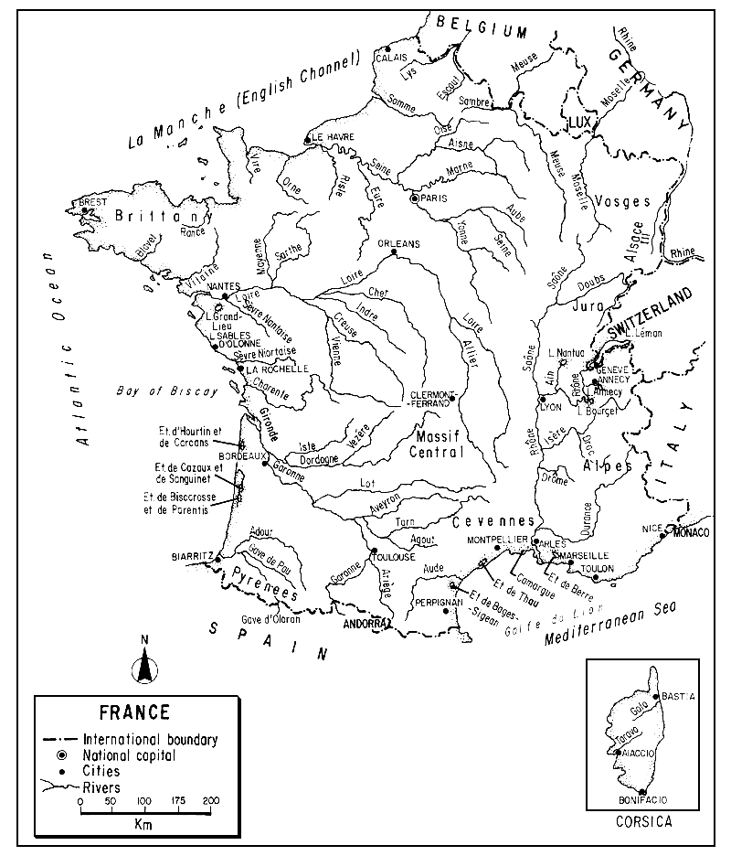
The French Republic, bounded by eight countries, the Atlantic and the Mediterranean, is the largest country in western Europe. Its terrain varies from coastal marshes through rolling agricultural lands and forests to snow-capped Alps and mountain meadows. France is rich in rivers, small streams and interconnected waterways. It possesses many small ponds and some coastal lagoons, but is deficient in large natural lakes.
Largely agricultural in land use and with most of its industry concentrated in the north, its waters remain of generally high quality for fisheries. They have, however, been greatly affected by modifications for transport and for hydroelectric development, resulting both in barriers to fish migration and creation of enlarged fishing waters.
Commercial fishing continues in inland waters, especially for diadromous or euryhaline species, but sport fishing far exceeds it in importance - both with respect to total catch and the number of participants. Salmonids, pike, perch and various cyprinids are among the most important sport fishes. Aquaculture for trout has become highly developed and the potentialities for brackishwater culture are good.
| 1. | AREA: | 547 026 km2 | |
| 2. | POPULATION: | 55 470 000 (est. 1990) | Density: 101 inh/km2 |
| 3. | PHYSICAL GEOGRAPHY | ||
France is situated in western Europe between 42°20' and 51°5'N latitudes and 8°15'E to 4°47'W longitudes.
A quadrilateral, its extreme length (N-S) is about 960 km; its greatest breadth (E-W) is 905 km. Its average elevation is about 400 m; more than one half of the land is above 200 m, but less than one quarter above 500 m. The altitudinal range is from sea level to the summit of Mt. Blanc at 4 807 m in the Alps.
France is bounded on the northeast by Belgium for 630 km and Luxembourg for 75 km, on the east by Germany for 435 km, Switzerland for 550 km, and ltaly for 500 km, on the south by Andorra for 60 km, and Spain for 690 km. It also bounds the principality of Monaco, an enclave of only 181 ha, on the Mediterranean in southeastern France. Its sea boundaries are the North Sea and English Channel (La Manche) for 1220 km on the north, the Mediterranean Sea for 1700 km on the south, and the Bay of Biscay and Atlantic Ocean (including islands) for 1 800 km on the west.
The coast of continental France including its islands and estuaries is 4 731 km in length. It has chalk cliffs in the north, rocky capes and bays in Brittany, and flat reaches in the southwest and along the Mediterranean including some coastal lagoons.
Physiographically, France can be divided as follows:
Four great dissected upland massifs (horsts) of granite and gneisses providing thin, infertile soils. These are the:
Armoricain Massif (including Brittany and a part of Normandy), of the north-west, a low, dissected peneplane never exceeding 425 m and occupying one eighth of the country.
Massif Central of eroded crystalline rocks and lavas averaging 915 m - a plateau area in the south-centre occupying one sixth of the country.
Vosges, wooded highlands of the northeast rising to over 1400 m.
Ardennes, also in the northeast and reaching into Belgium and Luxembourg, an area of narrow, incised valleys.
Three-fold mountain systems:
The Franco-Swiss Jura, low mountains, averaging 915 m, east of the Rhône and bordering Switzerland, heavily forested and with many lakes and a folded limestone upland.
The great Alps, in the southeast, high montane, mostly limestone and metamorphic rocks, with permanent snows, many cirques, moraines and hanging valleys.
The Pyrenees, high mountains to the south forming a border with Spain between the Atlantic and the Mediterranean, and composed of limestone and crystalline rocks with permanent snows and torrential waters. Never heavily glaciated, they lack the large lakes and glaciers characteristic of the Alps, and are lower in elevation, i.e., to 3 298 m in France.
Between these mountain systems are seven valley and coastal drainage areas:
Paris Basin. This basin, occupying almost one quarter of the entire country, is drained by the Seine, the Somme and to some extent by the Loire. The prevailing bedrock is limestone but includes clay and sand and is overlain in part by limon or weathered loess. Mostly under 185 m in elevation, it is the most important agricultural lowland of western Europe.
Aquitaine Basin. This great southwestern basin between the Pyrenees and the Massif Central and the Bay of Biscay, occupying about 15 percent of the country, is drained by the Garonne and Dordogne. Mostly alluvial fan (sandstone, clay, limestone) in the south and southeast, its northern extent of low flat plains behind coastal dunes is occupied in part by lagoons unconnected with the sea except for the shallow Bassin d'Arcachon. Many of its former marshes have been drained and the area planted with pines.
Flanders. This northeastern lowland of sand and clay is drained by the Lys and Escaut which continue into Belgium.
Alsace. Part of the great trough between the Vosges and the Black Forest, drained into the Rhine.
Lorraine. Scarplands and valleys between the Vosges and Ardennes, drained by the Meuse and Moselle.
Rhône-Saône Basin. This is a long down-faulted corridor running from north to south with the major rivers fed mainly by eastern tributaries from the Jura and the Alps.
Mediterranean Coast. Occupied in part by the Rhône delta with many irrigation canals, it is an area of dunes, lagoons, salt marshes and xerophytic vegetation. Sand spits cut off lagoons in the west; there are rocky jagged cliffs to the east.
In addition to its mainland (see above), the island of Corsica, with an area of 8 720 km2 and coastline of 802 km, is considered part of metropolitan France. Situated in the western Mediterranean, 225 km south of Nice, it is a mass of crystalline rock rising to 2 706 m. Covered with maquis, only a small part is cultivated. The rivers are short and torrential, but it has a number of productive lagoons.
France lies in the European mixed forest zone. Temperate deciduous trees (oaks and associates) are widespread but reduced through clearing. Higher areas range upward from pine, fir and beech to stunted Alpine vegetation and mountain meadows. Parts of the Mediterranean area have in addition to the olives, cypresses and the vine, a somewhat ravaged woodland, much of which is now maquis.
There is a wide variety of base rocks and soils, much of the country having been modified by centuries of intensive cultivation. The Massif Central, Armoricain, and Vosges have generally poor soilsgranitic and acidic. The soils of the Alps and Pyrenees, including limestone and metamorphic, range from alluvium to screes. The basins are variable, often limy, sometimes with heaths and swamps.
4. CLIMATE
The climate, which is temperate, has three types:
Atlantic or oceanic (soft, cool and wet) in the west;
Continental (warm summers, cold winters and drier) over most of eastern and central France; and
Mediterranean (hot dry summers and mild winters) along a narrow strip in the south.
With a wide spread in both latitude and altitude, there are striking differences in temperature. The mean annual temperature is about 10°C at Paris (north) and 14°C at Nice (south). The seasonal range is highest in the Rhineland (19°C) and smallest in Brittany (7°C). The greatest recorded range is -42°C to 40°C.
Rainfall is also variable throughout the country. In parts of the Pyrenees, Alps and Cevennes (Massif Central) it reaches 2 000 mm per year but in the Paris and Aquitaine Basins it is about 500 mm annually. Overall, the annual rainfall is around 750 mm a year, the maximum about 1 200 mm and the minimum about 550 mm.
Snow-cover ranges from none in the lowlands to periods of five to eight months in the higher mountains. Snowline in the Alps is at 2 400 to 3 000 m. Lakes over 2 000 m in the Alps and Pyrenees bear an ice-cover for most of the year, and the Rhine sometimes freezes.
The growing season, based on frost-free days, is about: 345 days in Brittany, along the Channel and on the Mediterranean; 275–300 days in the Paris Basin; less than 265 days in the Massif Central and higher mountains.
The total annual solar radiation in France varies from about 100 Kcal/cm2 in the north to 140 Kcal/cm2 along the Mediterranean.
5. HYDROGRAPHY AND LIMNOLOGY
The total area of inland water in France according to Table 7 is 1 400 km2 or only 0.25 percent of the total area. This is a ridiculously low figure as will be seen from the statistics that follow (sections 5.1 and 5.2). Dependent upon the source, these show a range of 1 830 to 2 454 km2 for the area of static waters alone. If to these one adds the areas estimated for fluvial waters (ranging from 1 263 to 1 309 km2), one obtains total areas for inland waters ranging from 3 093 to 3 763 km2 or from 0.56 to 0.69 percent of the total area of the country.
The approximate annual runoff from rainfall on French territory alone is 300 mm or 168 000 million m3. Added to this is 39 000 million m3 received from upstream countries resulting in a total annual river discharge leaving France of 207 000 million m3 (Van der Leeden, 1975; ECE, 1978).
Generally speaking, the slope of the land (from the Alps) and the direction of the rivers is to the northwest; the Rhône Valley is a notable exception, and there are some streams draining northeast. The Pyrenees form a natural boundary with Spain by following the watershed; consequently, almost no streams are common to both countries.
5.1 Rivers
Throughout most of this paper, the term “river” can generally be taken to include all fluvial or flowing waters, regardless of size. However, some of the French statistics make so many distinctions between various types of flowing water, based on both size and use, that whenever it appears necessary I have used both the French terms and their English equivalents as translated by their authors. With respect to flowing waters, the general order of progression in France is about as follows: fleuve (a stream that flows into the sea); rivière (a large stream that does not reach the sea); ruisseau (a smaller stream or brook); ruisselet (a brooklet). A fleuve côtier is a small coastal stream.
Arrignon (1985) classifies them more precisely according to width: rivières navigables, 100 m; rivières flottables, 22.5 m; petites rivières, 8 m; ruisseaux, 1 m; ruisselts, 0.5 m.
The length of the fluvial waters (cours d'eau or eaux courantes) of France has, in recent years, been estimated as follows: 258 574 km (Charpy, 1957), 300 000 km (Framji and Mahajan, 1969), 250 000 km (France/EIFAC, 1974), 270 650 km (Cons. Sup. de la Pêche, 1980), and according to Arrignon (1985), 270 265 km of which 225 000 km are salmonoid waters and 45 265 km are cyprinid/pike waters.1
With respect to the area of these waters, an even more difficult evaluation, Charpy (1957) states that It totals 130 950 ha, Cons. Sup. de la Pêche (1980) totals it as at least 126 350 ha, and Arrignon (1985) totals it as 70 765 ha of which 25 500 ha are salmonoid waters and 45 265 ha are cyprinid/pike waters.
Comparisons of the validity of such statistics appears useless, especially as most are of the same general order of magnitude and since it cannot be determined whether each author has included exactly the same components. In the present section the greatest attention will be fixed on statistics derived from the Cons. Sup. de la Pêche (1980).
Here it is stated that the 270 650 km of French streams include 11 800 km belonging to the public domain, and 258 850 km of private streams (cours d'eau non dominaux), i.e., those whose beds belong to the riparian owners (see Table 1).
Table 1
Length and average width of private French streams
| Type | Width (m) | Length (km) |
| Streams (cours d'eau) | 10.0 | 20 850 |
| Streams (cours d'eau) | 1.0 | 88 000 |
| Creeks (ruisseaux) | 0.5 | 150 000 |
| Total | 258 850 |
Source: Cons. Sup. de la Pêche (1980) French and English versions
Lawmakers have also established two categories of streams in France based on the presence of trout (Category 1) and on their absence (Category 2). Category 1 streams are characteristic of the mountains, although some fine lowland trout waters exist. Category 2 streams, also termed “white fish” or poisson blanc (referring to cyprinids) or “cyprinid-pike” streams are characteristic of the plains and peneplains; they have mixed populations of cyprinids, pike, perch, pike-perch, etc. (see Table 2).
Table 2
Extent and area of French streams according to their fishing categories
| Length (km) | Area (ha) | ||
| Category 1 (trout waters) | |||
| Brooks (ruisselets) | 150 000 | 7 500 | |
| Creeks (ruisseaux) | 60 000 | 6 000 | |
| Rivers (rivières) | 15 000 | 12 000 | |
| Total | 225 000 | 25 500 | |
| Category 2 (Cyprinid-pike waters)a | |||
| Creeks (ruisseaux) | 28 000 | 2 800 | |
| Small rivers | 6 000 | 4 800 | |
| Floatable rivers | 2 500 | 5 600 | |
| Navigable rivers | 8 765 | 87 650 | |
| Total | 45 265 | 100 850 | |
| Grand total | 270 265 | 126 350 | |
a To Category 2, one also adds 4 680 km or 5 000 ha of canals
Source: Cons. Sup. de la Pêche (1980)
The major rivers in France are listed in Table 3. Table 4 shows the discharges of 27 important rivers in mainland France and three in Corsica.
Table 3
Principal rivers of France (basin, river and length in km)a
| Escaut | ||
| Escaut | 430 | |
| Lys | 214 | |
| Scarpe | 100 | |
| Garonne | ||
| Garonne | 575 | |
| Ariège | 170 | |
| Tarn | 375 | |
| Aveyron | 250 | |
| Lot | 480 | |
| Dordogne | 472 | |
| Adour | 335 | |
| Charente | 360 | |
| Sèvre Niortaise | 150 | |
| Loire | ||
| Loire | 1 020 | |
| Allier | 410 | |
| Cher | 350 | |
| Indre | 265 | |
| Vienne | 350 | |
| Creuse | 255 | |
Mayenne (avec Maine) | 195 | |
| Sarthe | 285 | |
| Vilaine | 225 | |
| Blavet | 140 | |
| Rance | 110 | |
| Vire | 120 | |
| Orne | 152 | |
| Meuse | ||
| Meuse | 950 | |
| Sambre | 190 | |
| Rhine | ||
| Rhine (frontière) | 190 | |
| III | 208 | |
| Moselle | 550 | |
| Meurthe | 170 | |
| Rhône | ||
| Rhône | 812 | |
| Ain | 200 | |
| Saône | 480 | |
| Doubs | 430 | |
| Ardèche | 120 | |
| Isère | 290 | |
| Drôme | 110 | |
| Durance | 305 | |
| Argens | 115 | |
| Var | 120 | |
| Hérault | 160 | |
| Aude | 220 | |
| Têt | 120 | |
| Seine | ||
| Seine | 776 | |
| Aube | 248 | |
| Marne | 525 | |
| Oise | 302 | |
| Aisne | 280 | |
| Yonne | 293 | |
| Loing | 166 | |
| Eure | 225 | |
| Rille (ou Risle) | 140 | |
| Somme | 245 | |
Source: France, Institut national de la statistique et des études économiques (1982)
A general description of the major river systems follows:
Rhine. The Rhine (Rhin in French), one of the greatest rivers in Europe, concerns France for only 190 km (of its total length of 1 350 km) where it forms a border with Germany, where it is known as the Rhein. In this area it is still largely Alpine in regime with a swift current and a spring maximum, carrying much debris and subject to floods.
Tributaries of the Rhine originating in France include the completely French river, the 208-km III, and the 550-km Moselle, which joins the Rhine in Germany (where it is called the Mosel) via Luxembourg.
The Meuse Basin is also in the Rhine drainage. Originating in France, the 950-km Meuse is joined in Belgium by the Sambre (which also starts in France) and then proceeds to the Netherlands where it is called the Maas and forms a common delta with the Rhine. Another international stream, the 113-km Chiers, which originates in Luxembourg, joins the Meuse in France.
Loire. The Loire, the longest river in France and perhaps the least stable in regime, rises in the Massif Central and flows west, draining a fifth of France during its 1 020 km route to the Atlantic. With rapid runoff in its upper part where the ground is impermeable, it loses water in its lower broad flat bed through percolation and heavy summer evaporation. Although its average annual flow is about 875 m3/sec, it can drop to only 25 m3/sec in dry summers and then rise in violent floods to 12 000 m3/sec. Attempts to control the Loire by construction of dikes have been made since the Middle Ages. It has a 56-km estuary but is navigable in a limited sense for only 210 km.
The other major rivers in this basin are listed in Table 3.
Rhône. The 812-km Rhône, the eighth longest river in Europe, rises in Switzerland, passes for 72 km through Lake Léman (Lake of Geneva) and enters France 20 km below the Lake. Within France itself, where its course totals 550 km, it falls 371 m between Geneva and the Mediterranean. The Rhône catchment experiences many regimes: Alpine and upland, snow-rain and rain-snow, and even Mediterranean in the lower reaches. The Rhône has a rapid flow and the highest discharge of any French river, its average being about 2 200 m3/sec, and its greatest flood about 14 000 m3/sec. Due to Alpine snowmelt, its maximum flow is in May and June, its minimum in September. But the flow is rather regular due to the balancing effect of Lake Léman, snowmelt which occurs at a different time in the Jura, and the autumn and winter maxima in its western tributaries. It debouches through a great two-armed delta into the Mediterranean, discharging about 22 million m3 annually.
The chief tributary of the Rhône is the placid and highly navigable Saône (480 km), which helps balance its flow. Rising in the Vosges and entering near Lyon, the Saône's flow is greatly supplemented by its major tributary, the 430-km Doubs from the Jura. As one proceeds downstream, the Rhône is joined by a number of large less constant streams originating in the Alps, e.g., the torrential lsère (290 km) and the Durance (305 km).
Garonne. Draining about one-tenth of France, the Garonne (575 km) originates in the Pyrenees where it flows through Spain for 48 km and then proceeds northwest through France to the Atlantic Ocean north of Bordeaux. It has scanty storage at its head, there being only a few small lakes, little permanent snow and ice, and much impermeable rock in the Pyrenees. Similarly, there is little storage for its tributaries from the Massif Central. Despite some compensating effect from its different sources, the Garonne has an irregular regime with a seasonal maximum in the spring. It has an average flow of about 700 m3/sec, 300 m3/sec at low water, and floods to several thousand m3/sec.
In addition to its tributaries shown in Table 3, the Garonne is joined by the 76-km Salat, 40-km Arize, and 85-km Ciron. The Dordogne (472 km), which in itself constitutes a major system, rises in the Massif Central, is fed by tributaries such as the Cere (112 km), Vezére (192 km) and Isle (233 km) and merges with the Garonne at their common estuary, the Gironde. The Garonne is not navigable except in its estuary.
Seine. Rising in central France at an elevation of only 471 m, the Seine (776 km) flows north through Paris to the English Channel; it and its tributaries form the major drainage of the Paris Basin. Most of its course is through an area of permeable limestone in which it is deeply incised. The Seine is a very winding and sluggish river, e.g., a direct line from its source to mouth is only 402 km, but the river distance is 776 km, and at an elevation of only 36 m, it is still 360 km from the sea. It has a winter maximum and a summer minimum but its flow is fairly regular; it averages about 300 m3/sec, dropping to less than 50 m3/sec.
Many modifications have been made to the Seine to improve its channel so that it is now highly navigable, and it has navigable connexions with many rivers including the: Somme, Escaut, Sambre, Meuse, Rhine, Saône and Loire, it is connected to every corner of the country except Brittany and the west.
Its major tributaries are listed in Table 3. Among these, the 302-km Oise rises in Belgium and flows for 15 km to the French border.
Escaut. Rising in northern France, the Escaut crosses Belgium (where it is also known as the Schelde or Scheldt) to join the North Sea. Major French tributaries are the Scarpe (100 km) and the Lys which join it in Belgium. The Escaut is the master stream for many French and Belgian canals.
Table 4
Discharge of selected French rivers
| River and station | Basin area km2 | Mean monthly discharge, m3/sec | Year | Period of record | |||||||||||
| Jan. | Feb. | Mar. | Apr. | May | June | July | Aug. | Sept. | Oct. | Nov. | Dec. | ||||
| Moselle, Hauconcourt | 9 400 | 188 | 217 | 169 | 126 | 90.6 | 80.6 | 60.0 | 68.0 | 62.0 | 67.8 | 108 | 160 | 112 | 1950–60 |
| Meuse, Chooz | 10 120 | 240 | 251 | 172 | 132 | 99.0 | 68.0 | 47.9 | 54.5 | 66.0 | 78.5 | 131 | 218 | 129 | 1953–65 |
| Seine, Bazoches-les-Bray | 10 240 | 77.0 | 85.0 | 85.0 | 134 | 85.0 | 61.0 | 26.4 | 14.3 | 18.7 | 23.1 | 30.4 | 8.10 | 60.0 | 1962–65 |
| Seine, Vitry-sur-Seine | 31 300 | 136 | 164 | 223 | 282 | 207 | 138 | 62.5 | 48.5 | 97.5 | 116 | 118 | 345 | 161 | 1964–65 |
| Seine, Paris | 44 320 | 505 | 568 | 456 | 314 | 228 | 155 | 114 | 99 | 105 | 131 | 253 | 351 | 273 | 1927–61 |
| Yonne, Courton | 10 460 | 122 | 120 | 109 | 130 | 89.0 | 59.0 | 31.3 | 27.0 | 34.4 | 37.7 | 53.0 | 119 | 77.5 | 1961–65 |
| Marne, Noisiel | 12 580 | 150 | 158 | 130 | 102 | 78.5 | 54.5 | 38.0 | 36.5 | 46.4 | 43.8 | 72.5 | 119 | 86.0 | 1956–65 |
| Oise, Creil | 14 600 | 125 | 146 | 116 | 124 | 85.5 | 60.5 | 46.5 | 39.7 | 46.6 | 55.0 | 96.5 | 155 | 91.5 | 1960–65 |
| Allier, Pont-du-Guetin | 14 340 | 212 | 204 | 194 | 178 | 133 | 115 | 58.5 | 41.5 | 59.5 | 80.5 | 120 | 162 | 129 | 1955–65 |
| Loire, Montjean | 110 000 | 1 530 | 1 640 | 1 470 | 1 100 | 840 | 582 | 375 | 255 | 260 | 381 | 876 | 1 180 | 874 | 1921–60 |
| Loire, Gien | 35 890 | 552 | 591 | 531 | 442 | 365 | 263 | 135 | 90 | 104 | 187 | 404 | 484 | 345 | 1921–60 |
| Vienne, Nouatre | 19 650 | 383 | 250 | 266 | 263 | 185 | 113 | 94.0 | 68.5 | 91.5 | 124 | 193 | 363 | 200 | 1958–65 |
| Dordogne, Bergerac | 13 800 | 453 | 324 | 372 | 365 | 275 | 182 | 106 | 105 | 129 | 211 | 288 | 515 | 278 | 1958–65 |
| Vezére, Montignac | 3 125 | 96.5 | 104 | 81.0 | 64.5 | 53.5 | 36.0 | 23.9 | 18.6 | 20.8 | 36.2 | 63.0 | 88.5 | 57.0 | 1921–60 |
| Tarn, Rouby | 15 500 | 328 | 185 | 320 | 198 | 196 | 123 | 60.0 | 40.0 | 98.5 | 274 | 350 | 1 035 | 267 | 1923–33 1951–59 |
| Garonne, Mas d'Agenais | 52 000 | 861 | 938 | 917 | 822 | 762 | 544 | 279 | 175 | 190 | 274 | 487 | 839 | 590 | 1921–60 |
| Lot, Cahors | 9 170 | 229 | 229 | 186 | 124 | 93.2 | 70.3 | 34.0 | 29.7 | 32.4 | 60.5 | 131 | 203 | 118 | 1941–60 |
| Adour, St. Vincent de Paul | 7 830 | 143 | 136 | 101 | 81.6 | 72.4 | 64.0 | 31.0 | 21.0 | 26.9 | 40.1 | 67.9 | 109 | 74.5 | 1951–60 |
| Rhône, Chateaufort | 12 600 | 219 | 216 | 398 | 415 | 507 | 548 | 653 | 500 | 528 | 296 | 369 | 735 | 451 | 1965 |
| Rhône, La Mulatiere | 50 200 | 1 250 | 1 270 | 1 210 | 1 070 | 923 | 999 | 904 | 831 | 783 | 803 | 1 180 | 1 110 | 1 030 | 1921–60 |
| Rhône, Beaucaire | 95 590 | 1 887 | 1 888 | 2 005 | 1 870 | 1 873 | 1 899 | 1 429 | 1 173 | 1 199 | 1 422 | 2 026 | 1 863 | 1 712 | 1920–60 |
| Ain, Chazey | 3 630 | 132 | 128 | 211 | 157 | 94.5 | 74.0 | 51.0 | 84.5 | 95.0 | 90.5 | 148 | 171 | 120 | 1960–65 |
| Saône, Le Chatelat-Pouilly | 11 660 | 188 | 134 | 244 | 205 | 223 | 187 | 60.0 | 43.6 | 206 | 166 | 162 | 520 | 195 | 1965 |
| Ardeche, Sauze Saint Martin | 2 240 | 102 | 89.0 | 114 | 77.0 | 32.0 | 48.0 | 11.0 | 15.0 | 22.0 | 82.0 | 101 | 107 | 66.5 | 1955–64 |
| Isère, Veurey | 9 450 | 109 | 101 | 174 | 227 | 475 | 570 | 425 | 269 | 280 | 201 | 188 | 304 | 278 | 1965 |
| Durance, Jouques-Cadarache | 11 700 | 148 | 161 | 216 | 233 | 302 | 322 | 147 | 96.5 | 98.5 | 191 | 225 | 198 | 195 | 1951–60 |
| Escaut, Conde sur l'Escaut | 2 580 | 20.6 | 24.1 | 17.9 | 18.5 | 16.3 | 14.3 | 11.2 | 11.2 | 10.8 | 12.5 | 15.9 | 22.2 | 16.3 | 1961–65 |
| Somme, Abbeville | 5 560 | 28.6 | 28.6 | 29.6 | 30.0 | 25.9 | 24.5 | 25.7 | 25.0 | 23.2 | 22.6 | 25.8 | 33.7 | 26.9 | 1963–65 |
| Charente, Cognac | 4 630 | 80.0 | 48.3 | 64.0 | 46.6 | 40.7 | 25.5 | 21.7 | 16.3 | 38.9 | 45.4 | 61.0 | 195.0 | 57.5 | 1965 |
| Aude, Carcassonne | 1 794 | 37.2 | 36.5 | 44.4 | 51.5 | 51.0 | 30.6 | 14.4 | 9.3 | 8.5 | 10.0 | 13.5 | 21.1 | 27.3 | 1921–30 |
| Orb, Reals | 1 148 | 34.9 | 33.9 | 53.0 | 19.5 | 14.3 | 10.5 | 7.00 | 4.79 | 9.55 | 111.0 | 39.6 | 44.6 | 31.9 | 1957–62 1965 |
| Var, La Mescla | 1 827 | 25.5 | 26.5 | 35.2 | 46.5 | 67.5 | 61.5 | 50.5 | 22.1 | 25.6 | 37.9 | 45.3 | 35.7 | 40.0 | 1921–60 |
| CORSICA | |||||||||||||||
| Golo, Ponte-Leccia | 366 | 6.71 | 3.91 | 9.86 | 5.29 | 6.04 | 2.85 | 0.45 | 0.23 | 3.28 | 4.42 | 8.37 | 9.41 | 5.08 | 1965 |
| Tavignano, Altiani | 489 | 11.8 | 5.52 | 33.5 | 10.3 | 17.3 | 6.61 | 1.12 | 0.55 | 5.65 | 17.1 | 23.0 | 20.1 | 12.8 | 1965 |
| Taravo, Guitera | 157 | 5.96 | 3.96 | 8.37 | 5.87 | 4.66 | 2.10 | 1.08 | 0.84 | - | - | 6.21 | 8.13 | - | 1965 |
Source: Van der Leeden (1975) after Direction du Gaz et de l'Electricité (1966) and Unesco (1967)
In addition to these major drainages, there are many smaller rivers proceeding directly to the sea, e.g., the 245-km Somme with a 24-km estuary leading to the Channel, the Vilaine and the Adour (338 km) into the Atlantic, and the Aude (222 km) into the Mediterranean.
In summary, France has a wide variety of flowing waters: small, swift and unproductive Alpine torrents; large rivers with irregular regimes and steep gradients (e.g., Loire and Garonne); braided streams like the Rhône; some in deep gorges; and placid chalk-rich streams (rivières de craiae) such as the Risle, Touques, and Itan of Normandy.
In addition to such differences between individual waters, French streams often have zones differing markedly in physical and faunal characteristics. Following the general continental classification elaborated by Huet (1949, 1954, 1962) and proceeding generally downstream, these zones, named after a dominant fish inhabitant, are as follows:
Trout zone - rocky, swift, with cold and well-oxygenated water (e.g., most French headwater streams);
Grayling zone - less swift and less rocky, e.g., the Rhône from Lyon to Génissiat, the Ain and Loue;
Barbel zone - quieter water with more vegetation, e.g., the Rhône south of Lyon, the Seine, Yonne, Garonne.
Bream zone - localized in slow and tranquil rivers, comparable to ponds, e.g., most of the Saône, l'lndre and Cher.
Not all French rivers possess all these zones. For example, the grayling zone is not well represented in France, and the barbel zone often directly succeeds the trout zone. Furthermore, some heavily vegetated waters with low gradient may be excellent trout streams if the water is cold, e.g., in Normandy.
In addition to these four zones, the estuarial portions of French rivers are often of decided fishing importance especially for diadromous or euryhaline fishes, e.g., lampreys, shad, eel and elvers, mullets, sea bass and sole.
5.2 Lakes (Lacs)
Statistics on the number of lakes, their types and extent obtained from various French sources differ somewhat and have not been completely reconciled.
| Charpy (1957) listed the static waters of France as follows: | ||
| Lakes of the public domain | - | 50 000 ha |
| Reservoir or barrage lakes | - | 23 000 ha |
| Private ponds (étangs) | - | 110 000 ha |
| Total | - | 183 000 ha |
| France/EIFAC (1974) classed the lakes of France as follows: | ||
| Large lakes (public domain) | - | 61 700 ha |
| Reservoirs | - | 40 000 ha |
| Smaller ponds (private) | - | 110 000 ha |
| Total | - | 211 700 ha |
In this latter classification (similar to Charpy's) the group of “large lakes” included the 23 400 ha which is France's portion of Lake Léman (total area 581 km2) which it shares with Switzerland. It also included inland lakes such as Annecy and Bourget as well as coastal lakes and lagoons. Some of the latter group, Hourtin, Cazaux and Biscarosse, for example, are treated as inland waters whereas others come under maritime jurisdiction (see section 5.5). France/EIFAC (1974) also stated that the number of smaller lakes or ponds was approximate as no complete inventory of such waters existed, and that this category included some ponds which were used for extensive or intensive fish culture.
Other figures given for the extent of ponds in France are the 134 000 ha of “étangs en rapport” (ponds in production) in 1976 listed by France, Inst.Nat.Stat. (1978) and about 100 000 ha according to Matena and Berka (1987).1
The latest statistics received by EIFAC were those of the Conseil Supérieur de la Pêche (1980) which stated that the public domain of France included 31 700 ha of domanial lakes, not including the Grand-Lieu Lake of 3 700 ha. It also stated that there were some 210 000 ha of private lakes and ponds but that this figure was not constant as 1 500 ha of water bodies were created each year. It will thus be seen that some of the discrepancies between figures from various sources may be due to definition and inclusion or exclusion of what may be termed “reservoirs” (see section 5.3).
Arrignon (1985) said that the natural lakes of France totalled 50 000 ha.
No matter which statistics are selected, it is obvious that France is not well supplied with large natural lakes. The principal ones (in addition to France's portion of Lake Léman) are listed in Table 5, and some characteristics of four of the best known are shown in Table 6.
Table 5
Six principal natural lakes of France
| Lake | Area (km2) |
| Le Bourget (Savoie) | 45.0 |
| Grand-Lieu (Loire-Atlantique) | 37.0 |
| Annecy (Haute-Savoie) | 27.0 |
| Aiguebelette (Savoie) | 5.4 |
| Saint-Point (Doubs) | 4.0 |
| Gérardmer (Vosges) | 1.2 |
| Total | 119.6 |
Source: France, Institut national de la statistique et des études économiques (1982)
Table 6
Characteristics of four important lakes in France
| Parameter | Annecy | Lémana | Nantua | Bourget | |
| Altitude | m | 416 | 372 | 474.5 | 231.5 |
| Area (total) | km2 | 27 | 581.3b | 1.4 | 44.6 |
| Mean depth | m | 42 | 152 | 28.4 | 81.0 |
| Maximum depth | m | 82 | 310 | 43.0 | 145.0 |
| Capacity | km3 | - | 89 | - | - |
| Retention time | years | 3.3 | 12 | 0.7 | 8.0 |
| Primary production (rough average) | cm2/day | 292 | 1 015 | 523.0 | 2 050c |
| Temperature (min) | °C | - | 4 | - | - |
| Temperature (max) | °C | 20–24 | 24 | - | - |
b French portion is about 234 km2; the Swiss portion about 347.3 km2
Source: Pelletier (1978), Wojtenka, Gerdeaux and Allardi (1988) and Gerdeaux (1990)
Some of the French lakes are of glacial origin, e.g., Annecy and Bourget, and moraine lakes such as Lac de Chalain and Lac de Nantua. Some have been formed by landslides, e.g., Lac de Montriand (Haute-Savoie), Lac de Chaillexon (Doubs), and Lac de Sylans (Ain). The Jura has a number of tectonic lakes such as, the Lacs de Saint Point and Remorey. Lac de Narlay, also in the Jura, is a lake formed by dissolution of limestone.
Many of the lakes in the Massif Central are of volcanic origin. Some are found in craters, others have been produced in irregularities caused by volcanic (lava) action, e.g., Lac de Godivelle and Lac du Bouchet, Lac de Bourdouze and Lac d'lssarles.
Finally, lagoons and ponds or étangs occupy portions of the French coast. Some were formed by deltaic action, e.g., the Etang de Vaccares in the Camargue.
Others, separated by dunes from the sea, were developed by aeolian effects when wind-blown sands impounded the ponds or étangs, e.g., the étangs along the western coast (Landes) north of Biarritz.
The great subalpine lakes, such as Léman, Bourget and Annecy were originally oligotrophic, but are tending towards eutrophism today. They contain a mixed population of salmonoid fish (such as char and coregonids), percids, cyprinids, pike and burbot1. More numerous, however, are the eutrophic lakes such as those in the Jura, the lake of Nantua (Ain) is a typical example. There are also intermediate type lakes such as the subalpine lake Aiguebelette (Savoie) which is dominated by perch, pike and cyprinids with a poor population of coregonids and char. Finally, there are many humic lakes on acid soils, e.g., the lake of Gérardmer in the Vosges.
5.3 Reservoirs (Lacs artificiels; Lacs de barrage; Lacs de retenue de barrage)
Circa 1960, France had 103 artificial lakes totalling 17 460 ha, an 31 natural lakes, totalling 1 735 ha, which had been raised to become reservoirs (Vivier, 1960). By 1974, there were about 40 000 ha of reservoirs, in France, belonging generally to Electricité de France which has ceded the fishing rights to the State (France/EIFAC, 1974).
Reservoir lakes are abundant, especially in the Massif Central, and are in general eutrophic.
Table 7 is a list of French reservoirs (barrages) each with a capacity of over 100 million m3, compiled as of January 1990. The 25 then in service had a combined capacity of 7 247 million m3. Over half of these had been constructed since 1960.
5.4 Canals (Canaux)
Statistics on the number, length and size of inland waterways in France differ - as has been pointed out above - depending upon the source and interpretation. Thus, France/EIFAC (1974) records 11 800 km of canalized rivers, both it and Cons. Sup. de la Pêche (1980) record 4 680 km of canals. France, Inst.Nat.Stat. (1982) states that at the end of 1981, the length of used waterways in France was as follows: 3 908 km of streams, rivers, lakes and ponds (étangs) and 4 660 km of canals. Arrignon (1985) records 2 320 km (2 550 ha) of fish productive canals. Europa (1989) says there were 8 500 km of navigable waterways in France in 1987. France, Inst. Nat. Stat. (1991) records the total length of used waterways in France as 6 252 km.
In any event, canalization of natural waters is common in France, and in addition there are many artificial waterways which also provide fishing.
Table 7
French reservoirs with a capacity of over 100 million m3a
| Name | Total capacity (million m3) | Year completed |
| Serre-Ponçon | 1 270 | 1960 |
| Sainte-Croix | 767 | 1974 |
| Vouglans | 605 | 1968 |
| Bort-les-Orgues | 477 | 1951 |
| Marne | 350 | 1974 |
| Mont-Cenis | 322 | 1968 |
| Sarrans | 296 | 1932 |
| Grandval | 292 | 1959 |
| Monteynard | 240 | 1962 |
| Villerest | 128 | 1982 |
| Tignes | 230 | 1953 |
| L'Aigle | 225 | 1947 |
| Seine | 205 | 1965 |
| Roselend | 187 | 1961 |
| La Rance | 184 | 1966 |
| Le Chastang | 187 | 1951 |
| Parreloup | 169 | 1951 |
| Grand maison | 140 | 1985 |
| Castillon | 149 | 1948 |
| Saint-Etienne-Cantalès | 135 | 1945 |
| Naussac | 190 | 1981 |
| Orédon | 127 | 1982 |
| Salagou | 125 | 1971 |
| Le Sautet | 130 | 1935 |
| Vassivières | 107 | 1951 |
Source: France, Institut national de la statistique et des études économiques (1991)
5.5 Lagoons (Lagunes)
The extent of lagoons (i.e., littoral areas of shallow static water of various degrees of salinity connected with the sea) in France is unknown to me. Part of this is due to vagueness by various authors as to location of the lagoons, or their failure to specify them by name or as to their area. Part is a question of nomenclature. Most of the major lagoons in France are called “étangs”, a word which is also frequently used for freshwater ponds, whether natural or artificial. Some are called “lacs”, some “baie fermée” or “marais maritime”, or “salins”. Such usages make it difficult to distinguish between the various types of surface waters in France described in the literature.
Atlantic Ocean lagoons. Maps such as the fishing map issued by Cons. Sup. de la Pêche (1974) show the following large lagoons or étangs along the Bay of Biscay proceeding south from the Gironde: Etang d'Hourtin et de Carcans, Etang de Lacanau, Bassin d'Arcachon, Etang de Cazaux et de Sanguinet all connected by canals. South of these is the Etang de Biscarosse et de Parentis, and a number of smaller étangs, including Leon, Soustons, Blanc and Lac d'Hossegor.
Kiener (1978), in his monograph on brackish waters, has a section on “Lagunes des Côtes Françaises”, but with respect to France's western coast discusses only the small littoral ponds of Sables d'Olonne (between the Loire and the Gironde) and the 155-km Bassin d'Arcachon. He points out that little ponds contiguous to the Bassin once supported grey mullets (Mugil spp.) and sea bass (Dicentrarchus labrax).
Mediterranean lagoons. The fishing map cited above shows the following littoral étangs, proceeding in a generally easterly direction from the Spanish boundary along France's Mediterranean coast: Canet, Leucate, Bages-Sigean, Ayrolle, Thau, Mauguio, Etangs de la Camargue (e.g., Etang du Vaccarès), and Etang de Berre. To these a map, Petit and Schacter (1959), adds the following étangs: Ingril, Vic and Perols between the Etang de Thau and Etang de Mauguio (l'Or), and on the Rhône delta shows the small lagoons of: la Ville, le Roi, Imperial, Les Rieges, Fournelet, Gloria, Olivier, Lavalduc and Pos. Amanien, et al. (1981) and Quignard (1984) group the lagoons south of Montpellier as the “étangs palavasiens”: Vic, Pierre Blanche, Arnel, Prévost, Mejean, Perols, Grec and Mauguio. Reference to other maps disclose other nomenclatures and locations. Suffice it to say that although the Mediterranean coast of France has a large number of lagoons close to or at times connected to the sea, their extent is difficult to determine. For example, Levi and Troadec (1974) present a table indicating that France has six brackishwater basins or complexes in the Mediterranean totalling 31 500 ha in area with a depth of 3–10 m, and a salinity of 10–40 ppt. But Kiener (1978) says that the French littoral (apparently Mediterranean only) has 60 000 ha of lagoons including 3 000 ha in Corsica. Amanieu and Lasserre (1981) state that there are 120 000 ha of “lagunes” in the Golfe du Lion (the area from the Spanish border to Toulon) with a catch of 10 700 t, and Noel (1982) states that the French Mediterranean lagoons have 65 000 ha which have been finished for years, mainly for eels, and with a declining catch rate.
In summarizing their physical attributes, Petit and Schachter (1959) point out that almost all of the French Mediterranean lagoons lie along the Golfe du Lion in a region subject to constant geological modifications (the largest true French lagoon, the 15 000-ha Etang de Berre is an exception). This diverse cordon littoral has a history of instability; many of the lagoons have been opened or closed to the sea for varying periods, and have received varying amounts of fresh water. Among the principal factors determining their existence and their biological status have been the Mediterranean weather (high temperatures and evaporative rate, winds and occasionally torrential rain), floods, diversion of water, pumping, extension of rice culture, shifts in colonization from the sea, stock introductions, and man-engendered eutrophication. Surface temperatures are high (30–40°C) especially in shallow lagoons. Dissolved oxygen varies from about 7 ppm to zero, accompanied by liberation of hydrogen sulphide and consequent death of the fish fauna. Salinities in these lagoons vary from almost fresh water to hyperhaline (over 40 ppt).
As an example of the changes that occur in a Mediterranean lagoon, Kiener (1978) discusses the effect of changes in land and water use upon the biota of the Etang de Berre. Once a synclinal lake or freshwater body, changes in its outlet by the Roman general Marius (155-86 B.C.) caused it to become oligohaline. In 1925 it became salt (32 ppt) by the opening of a channel to the sea, and then in 1966, provided by fresh water through factory effluent, became desalinized to kill off its marine fauna and support euryhaline forms such as grey mullets, sea bass and eels.
The fish fauna in these lagoons varies from euryhaline species such as grey mullets (Mugil spp.), eel (Anguilla anguilla), gilthead (Sparus auratus), sea bass (Dicentrarchus labrax), and sole (Solea vulgaris) to carp (Cyprinus carpio), pike-perch (Stizostedion lucioperca) and other oligohaline species. There is a capture fishery in many of the lagoons, and in some it is somewhat allied to aquaculture (see section 7.2). However, Ravagnan (1981) says that among the great number of lagoons in France, the only ones which are to any extent “structured” as fish farms are those of the Perpignan region.
Corsican lagoons. Corsica, the French island directly north of Sardinia, is a special case. Kiener (1978) lists four lagoons here forming an ensemble of more than 3 000 ha: Biguglia, Diana, Urbino and Palo. Their fishery production consists of eel, grey mullet, sea bass, sparids, sole, atherinids and gobies. Ravagnan (1981) mentions Biguglia, Diana and Urbino as natural ponds. Amanieu and Lasserre (1981) state that there are 3 200 ha of “lagunes” in Corsica, providing 380 t annually. Frisoni (1981) states that the eastern part of Corsica offers a wide variety of lagoons covering about 3 000 ha. Among the most important of these, he lists the meso-polyhaline Biguglia, with an area of 1 500 ha and a depth of 1.8 m, and two euhaline lagoons with a depth of 9–11 m, the 570-ha Diana and 790-ha Urbino. In Biguglia there is traditional fishery using fixed “bordigues” which produced, in 1978, 170 t of grey mullets, sea bass and eels. Using the same techniques, Diana produced 6 t and Urbino 20 t. (See section 9.2 for yields from lagoons.)
6. LAND AND WATER USE
Table 8
Pattern of land use in France, 1986
| Percent | |
| Arable and permanent crops | 34.7 |
| Permanent pasture | 22.2 |
| Forest and woodland | 26.7 |
| Other land | 16.1 |
| Inland water | 0.25 |
| Total | 100.0 |
Source: 1987 FAO Prod. Yearb., 41 (Publ. 1988)
Although there has been only a small development of large urban centres in France, it is considered to be about 74 percent urban today. However, about 60 percent of the land is used for agriculture, primarily by small family holdings. Abundant cyclonic rain makes cultivation possible even on mountain slopes, but irrigation is increasing along the lower Rhône and in Languedoc1. In 1986, about 11 800 km or 2 percent of the country was being irrigated. Farming is diversified, being high in production of cereals, potatoes and sugar beets, and with a flourishing horticulture, great vineyards and vegetable gardens. Live stock production is also very high. There is heavy fertilization of crops in much of France, above the European average, a contributor to eutrophication.
There are about 4 million ha of conifers and 8 million ha of deciduous trees in the forests, and France ranks about third in Europe in roundwood production. Inclusion of stream care in forestry planning has long been a part of the French tradition.
Mining is important in France which ranks as Europe's first producer of iron and fourth of bauxite. Coal, potash, salt, sulphur, lead and zinc are also important. Gravel and sand extraction is high, especially from stream beds and often to the detriment of fisheries.
Although industry is widespread, it is nevertheless concentrated in the industrial north (iron, steel, chemicals and textiles), Alsace-Lorraine (iron and steel), near Lyon (chemicals, textiles and metallurgy) and around Paris (all types). Food processing, auto manufacture and aluminium are also important.
The 1987 contribution to industrial water pollution by major industrial segments is shown in Table 9.
Table 9
Contribution to industrial water pollution in France, 1987
| Industrial segment | Percentage according to industrial segment | ||
| Suspended materials | Oxidizable materials | Toxic materials | |
| Chemical | 24.0 | 16.4 | 52.3 |
| Agro-food | 24.5 | 45.6 | 0.2 |
| Metal | 14.6 | 8.9 | 33.9 |
| Wood, paper, etc. | 10.1 | 12.9 | 0.9 |
| Textiles | 5.5 | 8.7 | 4.4 |
| All othersa | 21.3 | 7.5 | 8.3 |
| Total | 100.0 | 100.0 | 100.0 |
Source: France, Institut national de la statistique et des études économiques (1991) after the Ministère de l'Environnement.
Pollutants from agriculture, mining and domestic wastes as well as from industry affect a considerable portion of France's national and international waterways. The Rhine, for example, is seriously injured by saline pollution from potash mines, and polluted rivers flowing into Belgium constitute another international problem. An inventory of water quality in 525 rivers throughout France made in 1971 and 1976 showed the principal pollutants to be: mineral materials (chlorides and sulphates), organic material, nitrogenous material, detergents and radioactivity. Oil pollution is high in some coastal areas. In person-equivalents, water pollution amounted to 76 million and was expected to be 100 million by 1985. Nevertheless, pollution from domestic wastes is subsiding. In 1988, 99 percent of France had a system of collection and 92 percent a system of sewage treatment.
In 1987, the installed electrical power capacity in France was 97 600 thousand kW. Although 25 percent of this was thermal energy, France's coal resources are declining and little oil is available (France is, however, the foremost producer of uranium in western Europe.) Consequently, nuclear energy (50 percent of the whole) is growing rapidly, the remainder (25 percent) is hydroelectric. With abundant water (at least seasonally) and steep gradients, France has good hydroelectric resources, and many impoundments have been constructed to produce electricity, especially in the Alps, Pyrenees and Massif Central. Many of these impoundments can also be used for fishing. There are also many barrages without true impoundment, e.g., on the lower Rhône. Much of the potential is still untapped, but the best sites have been used.
France has one of the densest road and rail systems in the world. Its road density alone is 2.7 km/km2 and private automobile ownership is high (396 per 1 000 people). This enables easy travel for angling and has been a factor in the increased fishing intensity occurring as a result of a higher standard of living. France will soon be linked to England by tunnel.
Although France's largest ports are at river mouths, its rivers are not suitable for navigation. Aside from size, the difficulties include extensive meanders (as on the Seine), uneven flow and presence of sandbars (as on the Garonne and Loire), shifting channels (as on the Rhine) and rapids (as on the Rhône). Nevertheless, an extensive programme of river regularization and canalization has created a complex system of interconnected navigable waters (see section 5.4)1. Despite the large canal system, its narrow channels and many locks make much of it unsuitable today for heavy transport except in the northeast with its mature river systems, evenly distributed rainfall, and presence of industrial centres. Heavy use of certain waterways and the presence of locks, weirs and pollution have been detrimental to anadromous fishes.
Despite rather abundant surface water resources, France is now drawing heavily on its ground water reserves, e.g., the Paris region gets about 40 percent of its water from underground. The tables are dropping and some pollution has occurred.
Commercial fishing even in marine waters is a relatively unimportant sector of the French economy (France ranked 21st in total world catch by weight in 1987) and only accounts for about 5 percent of its total nutritional supply, despite the relatively high per caput consumption of about 25 kg/year.
With respect to total water consumption in France, a survey in the 1950s (using its maximum figures) suggested the following proportions of a total annual consumption then of 28 900 million m3: 52 percent for agriculture, including irrigation, 36 percent for industry, including 23 percent for power and 12 percent for domestic use (House, 1978). Other figures (for 1976 by France, Inst.Nat.Stat., 1978) show that an allotment for surface water alone was distributed as follows: 53 percent to the power industry, 14 percent to other industries, 22 percent to agriculture, and 11 percent to domestic use.
Tourism is important in France; about 37 million tourists visited it in 1987. Fishing by tourists has increased but it is not a major attraction for them.
![]()
![]()
![]()