![]()
![]()
![]()
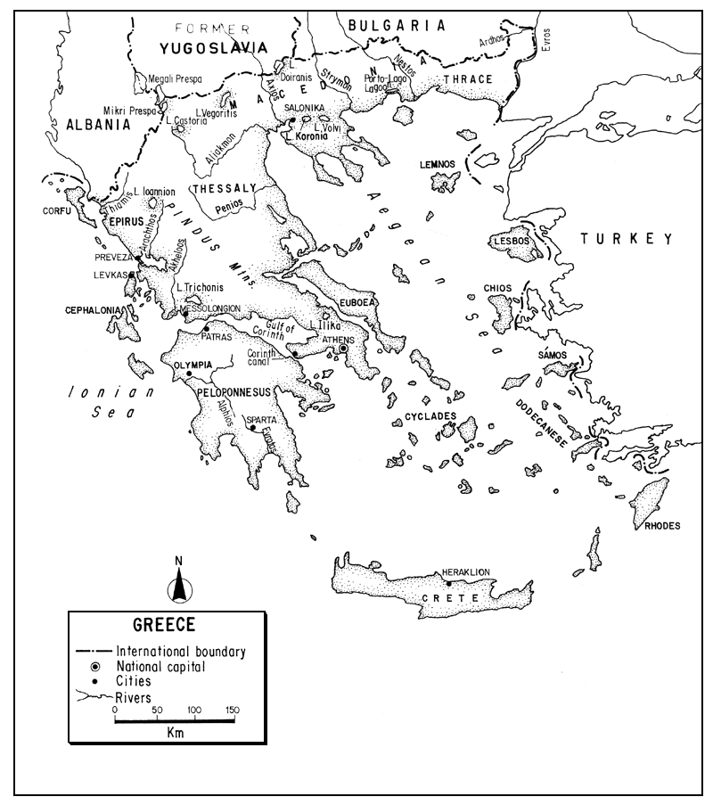
The Hellenic Republic, southernmost of the Balkan countries, lies between the Mediterranean's lonian and Aegean Seas. Although sea-oriented and sea-girt, with a galaxy of islands, it is primarily a mountainous country. Much of Greece is barren, eroded, and deforested, dissected by small rapid rivers and enclosing a few isolated basins.
Primarily agricultural, it is being industrialized in a few key areas, and here pollution problems are manifest.
Its few rivers, torrential in winter and water-deficient in summer, are incapable of providing good fisheries. The inland fisheries are concentrated in its natural lakes and in brackishwater lagoons. A so-called lagoon culture, actually a modified form of capture fishery primarily for euryhaline species, has considerable potential. True aquaculture is at present mainly in the form of trout culture, but is expanding into other fields. Inland sport fishing is at a minimum level.
| 1. | AREA: | 131 957 km2 | |
| 2. | POPULATION: | 10 085 000 (est. 1990) | Density: 76 inh/km2 |
| 3. | PHYSICAL GEOGRAPHY | ||
As part of the Balkan peninsula extending southward into the Mediterranean Sea, Greece is situated between 34°48'11" and 41°45'01"N latitudes and 19°22'41" to 29°38'39"E longitude.
Its greatest length (E-W) is 992 km, and its greatest breadth (N-S) is 793 km. Its altitudinal range is from sea level to 2 917 m on Mt. Olympus. About 67 percent of its area is above 200 m, and about 13 percent above 1 000 m.
Greece is bounded on the northwest by Albania for 247 km, or the north by former Yugoslavia for 256 km and Bulgaria for 475 km, and on the northeast by Turkey for 203 km1. A peninsula, its western flank is bathed by the lonian Sea, its eastern flank by the Aegean Sea.
About one fifth of its area is composed of more than 1 400 islands, of which less than 200 are inhabited. The sea cuts very deeply into the land to form an extremely long coastline. With islands excluded, the coast is about 2 700 km; with its islands it is about 15 021 km long, an extent surpassed by few other countries.
About 80 percent of Greece is mountainous, a southern continuation of the rugged mountains of Albania, former Yugoslavia and Bulgaria. Intermontane basins, valleys and plains, mostly covered with sands, marls and clays, make up 20 percent of the country.
On a very broad scale, Greece can be divided into two environmental regions:
southern or Mediterranean Greece and its islands.
Another way to describe the country is to divide it into five major traditional and geographical regions:
Greek Thrace and Macedonia along the northern border and fronting on the northern Aegean Sea;
below these the area of Northern Peninsular Greece composed of Epirus to the west on the lonian Sea, and Thessaly to the east on the Aegean;
Central Greece extending south to the Gulf of Corinth and including the Athens area;
the Peloponnesus or southernmost Peninsular area, and
Insular Greece, a fringe of islands some widely separated from the mainland.
Thrace and Macedonia. Thrace, the northeastern corner of Greece, is separated from Turkey by the Evros River and from Macedonia to its west by the Nestos River. Its northern border with Bulgaria runs through the Rhodope Mountains. Partly plateau and partly lowland, in addition to its two major rivers it has a large lagoon, Porto-Lago, connecting with Lake Vistonis, on its Aegean coast. Macedonia, lying between the Nestos River and the Albanian border, shares its mountain ranges with former Yugoslavia and Bulgaria and has important agricultural areas. Its major rivers are the Strymon, Axios and Aliakmon. Its major city is Salonika, the second largest city and port in Greece.
Northern Peninsular Greece. Its western section, Epirus, is an isolated area of high mountains of folded sandstones and limestone, poor uplands, and karst. On the windward side of the Pindus Mountains, it has high rainfall. Its soils are poor, but Epirus has some good areas for trout culture. To its east, and extending to the Aegean, is Thessaly which consists essentially of two basins linked by the Penios River. Its plains are the most important agricultural lands in Greece, constituting both granaries and cattle raising regions.
Central Greece. To the south, and extending to the Gulf of Corinth, is a more Mediterranean area, characterized by olive rather than oak trees. This region of plains, foothills, mountains, and rocky coasts supports the largest city and port area of Greece, the Athens-Piraeus complex.
Peloponnesus. Separated completely from the upper peninsula by the Gulf of Corinth and Corinth Canal, this is a mountainous area of few lowlands and a narrow indented coastal fringe. Partly karstic with underground drainage, its rivers, including the major Evrotas and Alphios, go dry in the summer.
Insular Greece. The 1 400 Greek islands are widely distributed throughout the surrounding seas, occupying 24 796 km2 (almost 20 percent) of the total area. Crete, the largest island (8 336 km2) is the fifth largest island in the Mediterranean. Other large islands are: Euboea (3 654 km2), the largest island in the Aegean; the two largest lonian islands, Cephalonia (781 km2) and Corfu (542 km2); Lesbos and Rhodes. Many of the lowland areas of Greece were once swampy and malarial. They, along with many of their shallow lakes, have been drained.
Although largely depleted, forests still occupy a fifth of the country. Aleppo pines and mixed deciduous trees (oak, beech and chestnut) are at lower altitudes, and conifers such as spruce are at the highest altitudes. Large areas of maquis (macchia) dominate the country, and much of the vegetation has been denuded.
Included within the great variety of soils, fissured limestone rocks prevail, followed by sandstone, crystalline rocks, and conglomerates. Mountain soils are thin, and strong karstic formations exist in many regions.
Most of the people live either in the large cities, such as Athens-Piraeus and Salonika, or in small scattered villages.
4. CLIMATE
Most of Greece enjoys classic Mediterranean climate, with the exception of the north which is continental. Broadly speaking, there are only two seasons: cold and wet (October to March), and hot and dry (April to September).
Under this regime, the average temperature ranges from 1.7°C to 41°C in the south and from -9°C to 35°C in the north. In August the average maximum temperature is 32°C in both Athens and Salonika. In January, the average minimum temperature is 5.5°C in Athens and 2.8°C in Salonika.
The average annual rainfall is about 700 mm, varying from 1 400 mm in the west to 350 mm in the east and southeast. Most of the rainfall occurs in late autumn and winter and is, therefore, of little aid to agriculture or in keeping the streams alive. Many of the higher mountain peaks are snow-covered for several months.
5. HYDROGRAPHY AND LIMNOLOGY
Key (1956) states that the inland water area of Greece including marshes is about 4 percent of the country's total area. A decidedly lesser estimate is that shown in Table 5, based on data contributed by Greece, indicating that Greece's inland water area is only 1 140 km2 or 0.86 percent of its total area. A higher estimate is that of Greece/EIFAC (1979) saying that the combined area of Greece's lakes (850 km2) and lagoons (400 km2) is 1 250 km2 or 0.95 percent of its total area. Aside from Key's figure, the highest figure known to the author given for all the area of Greece's inland waters (rivers, lakes, and lagoons) is that furnished by Kotsonias (1984): 2 100 km2 or 1.6 percent of the country's total area (see also sections 5.2 and 5.4).
The average annual runoff from rainfall on Greek territory is 150 mm or 20 000 million m3. About 23 000 million m3 is received from upstream countries, resulting in a total annual river discharge of 43 000 million m3 leaving the country (Van der Leeden, 1975; ECE, 1978). It is obvious that only the upper tier of Greek regions has much of a sustained river discharge.
The drainage pattern is influenced decidedly by porosity and solubility of the rocks in the limestone regions. Seasonal downpours are often “lost” almost immediately through seepage and runoff. The geologically young mountains of the north create a network of streams which fall into gorges, and the greatly indented coastline makes for short rivers. Coupled with the Mediterranean climate, none of these factors promote river systems suitable for navigation, irrigation, or productive fisheries.
5.1 Rivers
In northern Greece, the major rivers originate outside the Mediterranean zone, and although their water level is highest during the winter there is sufficient rain in summer to keep them in constant flow. On the other hand, the southern rivers, those on the eastern side of the peninsula, and those on the islands are torrential during the winter, fluctuate highly, and have very low summer discharges becoming intermittent or dry. In some of the mountain areas their slope is steep and they are in gorges. On level terrain their beds are wide and stony providing little habitat for fish. In karst areas, some simply disappear to run underground and re-emerge in the sea.
A list of the principal rivers of Greece appears in Table 1. The combined length of these 20 rivers is 2 339 km. Ananiadis (1972a) states that the surface area of Greece's productive rivers is 5 800 ha.
Only 13 rivers in the country have a summer discharge exceeding 3 m3/sec. The discharge of five of these is given in Table 2.
Table 1
Principal rivers and lakes in Greece
| Rivers | km | Lakes | km2 |
| Aliakmon | 297 | Trichonis | 96.5 |
| Akheloos | 220 | Volvi | 75.6 |
| Penios (Thessaly) | 205 | Vegoritis | 72.5 |
| Evrosa | 204 | Koronia | 47.9 |
| Nestosa | 130 | Vistonis | 45.6 |
| Strymona | 118 | Mikri Prespaa | 43.1 |
| Thiamis | 115 | Megali Prespaa | 38.3 |
| Alphios | 110 | Castoria (Orestiada) | 28.6 |
| Arachthos | 110 | lliki | 22.7 |
| Enipeus | 84 | loannion (Pamvotida) | 19.2 |
| Evrotas | 82 | Doiranisa | 15.0 |
| Louros | 80 | Petron | 14.2 |
| Sperkhios | 80 | Ambrakia | 13.6 |
| Megdovas | 78 | Lyssimachia | 13.2 |
| Axiosa | 76 | Chimaditis | 10.8 |
| Aoosa | 70 | Ozeros | 10.0 |
| Gallikos | 70 | Voulkaria | 9.1 |
| Ladon | 70 | Stymphalia | 3.3 |
| Mornos | 70 | ||
| Penios (Peloponnesus) | 70 |
a Length or area on Greek territory
Source: Hellenic Republic, National Statistical Service of Greece (1988) after Hellenic Military Geographical Service (lake areas rounded)
Thrace and Macedonia. The Evros (known as the Meric in Turkey and Maritsa in Bulgaria where it originates) forms the Greco-Bulgarian border for 16 km and then the Greco-Turkish border for 192 km. Turning south to form a delta in the Gulf of Enez, it completes a total journey of 483 km. A major tributary, originating in Bulgaria as the Arda, crosses Thrace to join the Evros as the Ardhos.
Farther west, the Bulgarian Mesta enters as the Greek Nestos, to form the boundary between Thrace and Macedonia, travel for 130 km in Greece, and form a delta in the Aegean at the end of its total journey of 241 km.
Table 2
Discharge of five rivers in Greece, 1937–67
| Akheloos (Kremasta) | Aliakmon | Axios | Strymon | Nestos | |
| January | 278 | 100 | 172 | 104 | 164 |
| February | 265 | 142 | 182 | 118 | 88 |
| March | 242 | 180 | 228 | 135 | 178 |
| April | 222 | 140 | 237 | 181 | 125 |
| May | 154 | 95 | 191 | 228 | 125 |
| June | 92.6 | 60 | 129 | 156 | 124 |
| July | 57.1 | 33 | 62 | 65 | 62 |
| August | 39.4 | 22 | 39 | 31 | 25 |
| September | 42.7 | 28 | 38 | 27 | 19 |
| October | 86.3 | 38 | 66 | 56 | 33 |
| November | 217 | 87 | 104 | 83 | 71 |
| December | 297 | 115 | 170 | 135 | 137 |
| Six monthly average: October–March | 230 | ||||
| April–September | 101 | ||||
| Yearly average | 165 | ||||
| Mean annual runoff l/sec/km2 | 46.3 | ||||
| Basin area: Total km2 | 9 455 | 24 662 | 16 553 | 6 178 | |
| Within Greece km2 | 9 455 | 1 818 | 6 027 | 2 524 | |
| Max. known flow m3/sec | 1 000 | 2 500 | 2 200 | 1 500 | |
| Min. known flow m3/sec | 9.0 | 12.1 | 5.5 | 9.6 |
Source: Van der Leeden (1975) after ECE, 1970
Van der Leeden (1975) after Chorafas, Water for Peace, 1963
Still farther to the west in Macedonia, the Strymon, originating in Bulgaria as the Struma, flows for a total of 346 km, with 118 km in Greece, to the Aegean.
West of the Strymon is the Axios, flowing for 76 km in Greece from former Yugoslavia (known there as the Vardar) to the Aegean west of Salonika.
The Aliakmon drains western Macedonia for 297 km into the Aegean.
Epirus, Thessaly and Central Greece. The Thiamis or Kalamas (115 km) enters the lonian Sea opposite Corfu. Well to the east, the Penios (205 km) drains much of Thessaly to enter the Aegean. Farther west in Epirus is the Arachthos (110 km) which flows south to the Ambracian Gulf on the lonian Sea, and to its east the Akheloos River (220 km) flows south to Messolongian on the lonian Sea.
Peloponnesus. The major rivers here are the Alphios (110 km) entering the lonian Sea near Olympia, and the Evrotas (82 km) running through Sparta to the sea. Most of the streams in the region drop steeply from the mountains to their narrow plains and then to the sea. Fed by winter rains they are typical of southern Greek streams, silt-laden in the winter, reduced to trickles in the summer.
5.2 Lakes
Information on Greek lakes varies decidedly. Belloc (1948) states that they are “…vast and numerous particularly in Thessaly, Epirus and Macedonia” and that their assemblage is composed of true mountain lakes, peneplain lakes, and valley lakes. Newbigin (1952) says that many lakes appear on the maps but that they are usually remnants filled by sediments and with a demise accelerated by drainage. Framji and Mahajan (1969) say that there are 16 lakes with a total area of 600 km2, wedged into closed (without any surface outlet) hollows, especially in semi-mountainous or mountainous zones, most of which are shallow up to 30–40 m. Ananiadis (1972a) says that the “productive” lake area is 400 km2. FAO (1975) says that 15 lakes have a total area of 600 m2, and Van Noort (1975) states that there are about 20 lakes with a total area of 655 km2 but includes an appendix (based on an unpublished report by D. Riedel) listing 19 freshwater lakes in Greece totalling 661 km2 in area. Finally, according to Greece/EIFAC (1979), the total lake area in Greece is about 850 km2.
A list of 18 principal lakes in Greece, using official Greek figures, appears in Table 1. The total Greek area of these lakes is 579.2 km2.
Table 3, listing 12 northern Greek lakes, shows, however, somewhat different figures for area, most of them somewhat smaller than those shown in Table 1, and in the case of Chimaditis a surprising difference in reported surface area (0.4 km2 instead of 10.8 km2). While - except in the case of Lake Chimaditis - the exact areas as well as the exact depths differ a bit depending upon the country's yearbook consulted, the estimates are reasonably close.
In the northern Greek lakes (see below) only Mikri Prespa and Megali Prespa belong to the Adriatic Basin. The remainder are linked to the Aegean Sea and are sometimes called the Aegean Lakes. They are all tectonic and date from the Tertiary, thus being much older than most of the European (Quarternary) lakes. Some of the other Greek lakes (e.g., Pheneos, Stymphalia and Karaklimn) are solution lakes.
Most of them are shallow and one (Lake Kerkini) has been transformed into an irrigation reservoir.
All of the northern lakes are alkaline (about pH 8). Doiranis, Castoria, and Mikri Prespa are dimictic; Volvi, Vegoritis and Megali Prespa are warm monomictic. Algal blooms occur on all of these lakes and there are dense beds of aquatic vegetation. With the exception of Vegoritis and Megali Prespa, they are all eutrophic. Koronia and Vistonis may even be considered hypertrophic. The trophic state has long been underway, but has advanced with agricultural development.
Three of the major lakes are shared with other countries1. Limni Megali Prespa, of which Greece claims 38.3 km2 or 14 percent of the total area of 274 km2, is shared with Albania (known there as Liqen i Prespës) and former Yugoslavia (Prespansko Jezero). This oligo-eutrophic cyprinid lake, at an elevation of 853 m, has a maximum depth of 54.2 m, an average depth of 20 m, and drains into Lake Ohrid (Albania and former Yugoslavia) through an underground channel. Only a small tip of Limni Mikra Prespa or Ventrok lies in Albania (known there as Liqen i Prespës se vogël); 43.1 km2 lies in Greece. The third international lake, Doiranis, lying at an elevation of 148 m, has a total area of 43 km2 of which 15 km2 (35 percent) lies in Greece, and the remainder in former Yugoslavia where it is known as Doiransko. This eutrophic lake has a maximum depth of 10.4 m and a mean depth of 6.5 m. A typical representative of the “Aegean lakes”, it is quite productive of cyprinids.
D. Riedel (in an unpublished report cited by Van Noort, 1975) states that of 19 major freshwater lakes in Greece, 19 contain cyprinids (10 of these with carp), 9 contain eel, 5 catfish, 1 mullet, 2 or perhaps 4 trout, and 2 crab.
5.3 Reservoirs
Circa 1972, there were 2 000 ha of reservoirs (Ananiadis, 1972a).
The largest reservoirs, used mainly for hydroelectric production, are: Kremaston and Kastrakiu (Aetolokarnania prefecture), Tarropu (Karditsa pref.), Polyphytu (Kozani pref.) and Peneiu (Elia pref.) which is used for irrigation (Greece/EIFAC, 1979). Kremaston on the Akheloos River is one of the world's major dams, 124 m in height, and impounding 4 750 million m3.
5.4 Lagoons
As used here (and in other sections of the text), the term “lagoon” refers generally to a coastal body of water in permanent or intermittent connection with the sea by either natural or artificial means. Often on deltas, they are generally brackish (i.e., a combination of fresh and marine waters), shallow, and productive biologically. Lagoons that have a connection with the sea have mixed populations of brackish or euryhaline fishes. These generally enter the lagoon in the spring and attempt to return to the sea in autumn, but some (e.g., eel) may remain longer, and some lagoons with considerable fresh water may have permanent populations such as carp.
In Greece, the term “lagoon” is sometimes applied to basins with somewhat different characteristics, for example to coastal “étangs” which may be situated farther inland, or in some cases what are really “embouchures” or embayments with only marginal closure to the sea, say by a chain of small islands. In general, they are quite shallow, but some are relatively deep. For example, the large lagoon of Messolongion (14 750 ha) on the west central coast of Greece has an average depth of only 0.45 m and a maximum depth of only 1.65 m, but its arm, the Lagoon of Etolico (1 750 ha), has a maximum depth of 30 m. Salinities vary decidedly, ranging from (mixo-) oligohaline even to hyperhaline, and differing not only from lagoon to lagoon but seasonally. Messolongion, for example, has varied seasonally from 2.7 to well over 50 ppt in some places. Water temperatures also vary a great deal throughout the year, e.g., in Messolongion they vary annually from about 12°C to 28°C and may even be lower. For euryhaline and eurythermic species, such as mullet, eel, sea bass and gilthead, salinities of 15–30 ppt and water temperatures from 18°C to 25°C are favourable.
There are some very extensive lagoon areas in Greece primarily along the northern Aegean and eastern lonian seas. Both old and new reports vary decidedly as to their individual and total extent. Nevertheless, for what it is worth, and in order to concentrate attention on some of the discrepancies in order to attain future accuracy, there follow some accounts of general location and size of Greek lagoons.
Table 3
Characteristics of lakes in northern Greece
| Lakes | Altitude (m) | Surface area (ha) | Mean depth (m) | Maximum depth (m) |
| Vistonis | 15 | 4 500 | 2.0 | 3.5 |
| Koronia | 75 | 4 200 | 6.6 | 8.5 |
| Volvi | 37 | 6 860 | 13.5 | 23.0 |
| Kerkini | 35 | 6 000 | 5.0 | 15.0 |
| Doiran | 148 | 1 560a | 6.5 | 9.8 |
| Veggoritis | 540 | 7 000 | 25.0 | 46.0 |
| Petron | 572 | 1 400 | 2.0 | 4.0 |
| Zazari | 650 | 200 | 3.5 | 5.0 |
| Chimaditis | 673 | 400 | 3.0 | 4.0 |
| Kastoria | 688 | 3 237 | 3.5 | 9.0 |
| Mikri Prespa | 853 | 4 841a | 6.7 | 7.9 |
| Megali Prespa | 853 | 3 764a | 18.0 | 55.0 |
a Excluding area in other countries
Source: Crivelli (1990)
One of the most comprehensive reviews of Greek lagoons is that of Belloc (1948) made shortly after the second world war at a time when damage had been done to a number of lagoon areas and production diminished. He catalogued the Greek lagoons as follows:
“6 on the coast of Thrace and 1 in Macedonia,
2 in the island of Corfu,
1 on the island of Leucade,
4 lagoons or groups of lagoons in the Gulf of Preveza,
1 on the coast of Acarnania,
1 group Missolonghi-Aetolikon on the coast north of Patras,
6 in Peloponesos: 3 in Elis and 3 in Messenia”1
He then specifically listed 21 groups including 45 individual waters. In addition to these, he listed eight which were in bad condition and stated that there were a considerable number of others that could be used as “vivari” or fish farms. It is difficult to identify all of the lagoons that Belloc listed with those described by later authors, but a number of the largest and most identifiable, at least as to general area, if not exact boundary, together with the areas and reported annual fish production are shown in Table 4. The lagoons he described varied from 15 000 ha to less than 100 ha in extent and generally in depth from 0.5 to 1.5 m. They thus became very warm in summer and cold in winter, and changes in salinity were also great, e.g., the upper part of Porto-Lago was almost fresh (limnetic) while parts of Messolongion were recorded as having a salinity of 43 ppt. Belloc further noted that mortalities of incoming fish from the sea sometimes occurred following floods of the entering rivers.
A review of Mediterranean brackishwater lagoons by De Angelis (1960) stated that there are numerous extensive lagoons in Greece, especially those of Thrace, Macedonia and Epirus. He did not estimate their total area, but listed a number of the most important ones with areas ranging from 14 000 to 200 ha (see Table 4).
Ananiadis (1972) says that all the lagoons and salt pounds in Greece cover a surface of almost 60 000 ha, and in another paper (Ananiadis, 1972a) says that there are about 50 000 ha of “lagunas” and “étangs” (said not to be “lakes”) in Greece. In another report, published 12 years later Ananiadis (1984) says that the total area of Greek lagoons, including coastal “étangs”, “embouchures” and estuaries, is 43 448 ha. A table in that report lists 61 lagoons or brackishwater fishing grounds and their areas. The three largest are: Porto-Lago (10 000 ha), Messolongion (6 100 ha), and Tsoukalia (4 200 ha). Although this is the most comprehensive recent report on the lagoons of Greece that I have seen, difficulties in trying, to match the lagoons of one report with those of others make it useless to try to duplicate them all1. The reader is, therefore, referred directly to this report for details and I shall only try to use his overall statistics in this discussion (see below).
Somewhat earlier, Van Noort (1975) said: “The more important brackishwater basins of Greece are found in the area of Messolongion, Cape Meraion, Preveza, and near Xanthi (Lake Vistonis). Smaller brackishwater inlets are known under the names: Nikola, Kawoura, Mama, Papuschak, Levkos, Xithia and Khoma. Lagoons are found mainly along the west coast of the Peloponnesus and the district of lpiros.” He also stated that the total surface of about 50 brackishwater lagoons and basins in Greece was estimated to be around 20 000 km2 (2 million ha). Such an enormous estimate, representing 15 percent of the total area of the country, is, of course, quite erroneous.
FAO (1975) stated that there were 50 lagoons in Greece with a total area of 40 000 ha.
Kiener (1978) grouped the lagoons of Greece into:
those of the Macedonia coast north of the Aegean Sea, totalling 7 500 ha, i.e., a total of 24 500 ha of Greek lagoons.
Table 4
Areas and yields of some Greek lagoons, 1948–64
| Lagoon | Annual production/yield | Remarks | Reference | ||
| Approx. area (ha) | Total (kg) | Per unit area (kg/ha) | |||
| Porto-Lago (Bouron or Vistonis) | 12 700 | 640 000–1 000 000 | 50–80 | Belloc (1948) | |
| Porto-Lago | 5 000 | 400 000 | 80 | De Angelis (1960) | |
| Porto-Lago | 10 000 | 500 000 | 50 | Annual prod. includes Lake Vistonis | Ananiadis (1972a) |
| Vassova | 200 | 12 000 | 60 | Vassova, Karassu and Kuburnu, virtually one lagoon on Aegean Sea, Macedonia | De Angelis (1960) |
| Karassu | 1 000 | 50 000 | 50 | De Angelis (1960) | |
| Kuburnu | 1 000 | 20 000–40 000 | 20–40 | De Angelis (1960) | |
| Tsoukalia | 5 715 | 12 820a | 2.2 | Gulf of Amvrakikos, lonian Sea | Belloc (1948) |
| Tsoukalia | -- | 80 000–120 000 | -- | Including Lake Rhodis | De Angelis (1960) |
| Voulkaria | 1778 | 25 600 | 14 | Amvrakikos Gulf | Belloc (1948) |
| Voulkaria | 1 200 | 26 000 | 22 | De Angelis (1960) | |
| Messolongion | 15 000 | 230 000 | 15 | Group of about 10 lagoons, 0.5–2 m | Belloc (1948) |
| Messolongion | 14 000 | 800 000–1 000 000 | 57–71 | De Angelis (1960) | |
| Messolongion | 16 000 | 900 000b | 56 | Pillay (1966) | |
| Pappas | 1 000 | 51 280 | 51 | West Peloponnesus | Belloc (1948) |
| Pappas | 400 | 80 000b | 200 | Pillay (1966) | |
| Prokopas | 500 | 16 000 | 32 | West Peloponnesus | Belloc (1948) |
| Prokopas | 100 | 14 600b | 146 | Pillay (1966) | |
| Kotichi | 1 200 | 40 000c | 33 | West Peloponnesus | Belloc (1948) |
| Kotichi | 750 | 51 257d | 68 | Pillay (1966) | |
| Kotichi | -- | 41 024e | 55 | Pillay (1966) | |
| Mouriaf | 341 | 60 710b | 178 | West Peloponnesus | Pillay (1966) |
| Agoulinitisaf | 2 250–1 500 | 1 000 000 | 444–666 | West Peloponnesus | Belloc (1948) |
| Agoulinitisa | 996 | 109 200b | 110 | Pillay (1966) | |
a Yield in 1945 when conditions were not good
b Yield for 1963/64
c Yield before the second world war
d Yield for 1961/62
e Yield for 1962/63
f Now drained
In one of the latest, and presumably most authentic, reports directly available to the author (Greece/EIFAC, 1979) the principal lagoons of Greece were listed as follows:
| Hectares | |
| Vistonida (Porto-Lago area, Thrace) | 5 500 |
| Nestu (several lagoons) (Macedonia) | 2 400 |
| Tsoukalia (lonian Sea) | 4 000 |
| Logaru (lonian Sea) | 5 000 |
| Messolongion (lonian Sea) | 18 000 |
| Rodopis (several lagoons) | 800 |
This same source stated that the total area of Greek lagoons was about 40 000 ha.
Amanieu and Laserre (1981) gave a total area of 27 591 ha for the Greek lagoons: 7 400 in Macedonia, 17 000 in Epirus, and 3 191 in the Peloponnesus.
Mistakidis (1982) quotes the Greek Deputy Minister of Agriculture as saying that Greek lagoons cover 53 000 ha, and the Greek Ambassador to Italy saying that they cover 60 000 ha, but in another section of this report states that the total area of Greek lagoons, normally State property, amounts to 34 000 ha.
Finally, a report by Kotsonias (1984) of the Greek Fisheries Department says that there are 72 lagoons in Greece covering 55 000 ha.
We thus have, over a period of years, individual estimates of both the size of individual lagoons and their total area which differ widely. Disregarding the estimate of Van Noort (1975) - possibly a misprint or lapsus calumi - we have quoted estimates of their total area in Greece ranging from 24 500 to 60 000 ha. Considering all the evidence, a figure of around 40 000 ha seems reasonable to the author. Nonetheless, variance in reported measurements of individual lagoons (and later total compilations) is not surprising. As has been pointed out above, such variance may depend upon one's definition of a “lagoon”, e.g., whether it is merely an embayment or a very separate water body. It is also dependent upon whether the named lagoon is classified as an entity or merely part of a larger complex. It may depend upon whether its area was determined at low or high water: in such shallow waters a slight rise or fall in level makes a considerable difference in measured area. It may also depend upon whether either natural or man-made changes have occurred since earlier surveys. Similarly, catch statistics for lagoons may vary for a variety of reasons, including especially the validity of the fishermen's reports (see sections 7 and 9.1).
All of the lagoons are part of the public domain, and are rented out by the State to individuals or cooperatives for fishing. The State will also construct weirs or other installations needed for lagoon culture. Circa 1978, there were about 50 leases for lagoons or marine fish farms. Ninety percent were leased to cooperatives and ten percent to individuals. Some are not yet rented, and others are in poor condition for such a practice.
It should be noted - despite many statements to that effect - that the primary lagoon fishery in Greece is not true aquaculture or even “valliculture” as practiced in Italy on the Adriatic lagoons. It is primarily a capture fishery of fish allowed to enter from the sea when attracted by fresh water in the spring and (generally) caught as they migrate out in autumn of the same year. The process varies, depending upon the lagoon, the seasons, and local practice, for example, fish may enter as early as February and March, the lagoon will then be closed, and fishing may start in July. When caught at fixed installations, such as reed enclosures or metal fences, the process is sometimes termed “traditional pisciculture”. In other cases movable nets and other gear, such as longlines are used (see section 7.1).
6. LAND AND WATER USE
Table 5
Pattern of land use in Greece, 1986
| Percent | |
| Arable and permanent crops | 30 |
| Permanent pasture | 40 |
| Forests and woodland | 20 |
| Other land | 9.4 |
| Inland water | 0.86 |
| Total | 100.0 |
Source: 1987 FAO Prod. Yearb., 41 (Publ. 1988)
Agriculture, still the base of Greek economy (although about 65 percent of the country is considered urban), suffers from mountainous terrain, poor soils, droughts, and erosion, the latter caused in part by deforestation and overgrazing. Nevertheless, Greece's very small holdings produce a large quantity of cereals, tobacco, sugar beets, cotton, olives, and other fruits. Animal husbandry is primarily pastoral in nature. Irrigation, of over 28 percent of the cultivable land, or over 8 percent of the total land (1986) is indispensable for successful agriculture, thus creating a severe demand for water. About 1/80 of the average runoff of the major rivers is used for irrigation, and some of the lakes are also used for this purpose. Fertilization is not widely practised, being at about the bottom of the European practise.
Land reclamation has long been practised in Greece. There has been considerable drainage of lakes and marshes to extend the area of cultivated land and to promote controlled irrigation. In the course of this process, some major aquatic areas have been destroyed. The karstic Lake Copais in central Greece was drained at the end of the Nineteenth Century to provide 20 000 ha to produce cotton. Lake Yiannitsá in the Axios floodplain and Lake Tachinos in the Strymon drainage have been drained for farmland, and about one-third of the shallow Lake loannion, largest lake in the Epirus, was drained for agriculture in 1958. Lagoons have also been affected. For example, both Mouria and Agoulinitisa in the Peloponnesus have now been drained and devoted to agriculture. The 341 -ha Mouria once produced over 60 t of fish annually, and Agoulinitisa, formerly a marsh transformed by sand dunes into a lagoon is reported to have produced 1 000 t of fish when its area varied between 1 500 and 3 000 ha, a remarkable yield of 444–666 kg/ha/year (Belloc, 1948). Even at the smaller size of 996 ha in 1963/64, it produced 109.2 t or a yield of 110 kg/ha/year (Pillay, 1966).
Forestry is unimportant in Greece, where roundwood production is almost the lowest of any European country, and firewood and secondary products are the principal forest derivatives. Afforestation may aid the water supply, but it will be a long process. Much of Greece has been denuded of vegetation both through overgrazing and intensive use of wood through the centuries.
Minerals are widely dispersed, although not abundant. Lignite (now approaching exhaustion), peat, iron ore, bauxite, nickel, magnesite and marble are important. There have been some recent offshore oil discoveries and there is some uranium.
Industry is increasing with emphasis on: food processing, metallurgy, chemicals, plastics, textiles, machinery, and rubber. It is still mainly concentrated near Athens and the inner Gulf of Salonika, and at Patras, Volos, and Heraklion. Some of these areas are badly polluted, but in general no large polluting effluents are produced except in these areas.
With respect to pollution in general, it can be noted that lack of sewer development in much of rural Greece has, in fact, kept the streams in better shape than they might be otherwise. However, if the interior were more densely populated, severe pollution problems could occur during the hot dry summers.
In 1987, the total installed electrical power capacity of Greece was 10 198 000 kW of which 2 137 000 kW (21 percent) was hydroelectric. The rest was thermal (8 059 000 kW), using largely imported petroleum, and 2 000 kW were geothermal. There are important hydroelectric schemes on the Akheelos, Ladon, Loudhias, Louras and Megdovas. Most of the large reservoirs have been developed for hydroelectric production, but this has also improved stream regulation for irrigation, and increased fishery potential. Transport by rail and road (about 2 500 km) throughout most of the country is reasonably good, although the mountainous terrain makes road-building difficult, and road density is very low (only 0.38 km/km2 in 1989). Automobile ownership is amongst the lowest in Europe, only about 143 passenger cars per 1 000 in 1987. The inland waterway system consists of three coastal canals, e.g., Corinth and Levkas, each about 6 km long, and three unconnected rivers, providing a total navigable length of less than 80 km with little effect upon inland fisheries.
Although groundwater horizons are generally poor, most domestic water comes from this source, thus lessening demands upon rivers for this purpose.
In general, both marine and inland fisheries are used primarily as a source of food; the supply of fish per caput is about 17.8 kg/year. In 1978, the inland fishery catch represented about 7 percent by weight of the total Greek catch and more than 15 percent of its value (Greece/EIFAC, 1979). Fisheries in rivers are not very important except in their lower courses. Lakes and lagoons are used largely for commercial fisheries (see section 7).
Tourism based on a sunny climate and great history, is a highly important industry in Greece (over 8 million people in 1987), but inland fishing is not an important element of its attraction.
7. FISH AND FISHERIES
Inland fisheries in Greece include the use of fluvial, diadromous, and euryhaline species.
The most important of the fishes exploited commercially in Greek lakes are cyprinids, such as common carp (Cyprinus carpio), roach (Rutilus rutilus), barbel (Barbus barbus), bleak (Alburnus alburnus), and tench (Tinca tinca), as well as the European perch (Perca fluviatilis), pike (Esox lucius), and European eel (Anguilla anguilla). Both carp and tench are said to have been introduced into a number of the Greek lakes from Italy. Other exploited fish are chub (Leuciscus cephalus) and European catfish (Silurus glanis). The brown trout (Salmo trutta) is found in some of the colder waters, and certain lakes are stocked artificially with rainbow trout (Oncorhynchus mykiss). The crayfish (Astacus fluviatilis) is also of some importance as an export product.
In the lagoons, the major fishery is for species that enter from the sea: grey mullets (Mugil spp.), gilthead (Sparus auratus), sea bass (Dicentrarchus labrax), European eel and sole (Solea vulgaris). Other fishes, such as sturgeons, atherinids, and gobies may also enter the lagoons or lower courses of some rivers from the sea, and there may also be an influx of freshwater fish, such as carp and roach from above.
The giebel (Carassius auratus gibelio) (now common in the Romanian inland fishery) has been introduced into most of the northern lakes. Other introductions include the American pumpkinseed (Lepomis gibbosus), the Chinese silver carp (Hypophthalmichthys molitrix), and a relative of Rutilus, Pseudorasbora parva from Asia. The presence of this species is probably a result of Albanian introduction into Limni Megali Prespa.
7.1 Capture Fisheries
7.1.1 Commercial fishing
Commercial fishing in the inland waters of Greece is primarily confined to the lakes and lagoons.
Table 6 lists the catch statistics during the period of 1965–87 for the inland waters of Greece compiled by Alieia Fishing and by FAO. (No inland water fishing statistics for Greece seem to have been available to FAO until 1970.)
Unfortunately, the exact percentage of the “catches” listed in Table 5 attributable to commercial capture fisheries cannot be determined from the table. Some are attributable to production (primarily of trout) through aquaculture, and the only definite statistic on this subject available to the author is that of Greece/EIFAC (1979) stating that of a total production from the inland waters of Greece in 1978 of approximately 9 000 t, 2 500 t (28 percent) were derived from aquaculture1. This would mean that about 6 500 t (72 percent) resulted from the Greek capture fishery in that year (see also section 7.2).
1 FAO's FISHDAB lists a figure of 9 595 t as Greece's total inland fish “catch” in that year
The comparative catch over the years from freshwater lakes and brackishwater lagoons is also difficult to ascertain. As early as 1947, it was estimated that the inland water commercial fish catch for Greece for that year, i.e., 5 000 t, was composed of 3 000 t (60 percent) from fresh waters, and 2 000 t from lagoons or brackish waters (Howard, 1950). Twenty three years later, the catch of 6 955 t from lakes and lagoons in 1970 reported by Ananiadis (1972a), was composed of 4 920 t (70 percent) from lakes and 2 035 t (30 percent) from lagoons. Five years later he (Ananiadis, 1977) stated that the annual yield during the last eight years from more than 130 km2 of inland waters, in Greece, in which he included lakes, lagoons, rivers, swamps, and reservoirs, amounted to 8 000 t, consisting mainly of carp, roach, tench, pike, perch, and mullets. He further stated that this yield from inland waters constituted 7.3 percent of the total Greek production of marine and inland fish, and separated it from aquacultural production which he said amounted to 1 700 t annually (see section 7.2). In that report he made no distinction between the harvest from lagoons and other inland waters, but in an article seven years later (Ananiadis, 1984), writing only of lagoons, coastal “étangs”, “embouchures”, and estuaries, stated that the annual production from 61 lagoons or brackishwater fishing areas totalling 43 448 ha, was 2 052 t. (The year was not specified; it appeared to be circa 1980.)
An ADCP (1979) Mission which visited Greece in 1978, estimated that the country's “annual production from lagoon culture includes: 100 t of sea bass, 300 t of sea bream, 1 100 t of mullet, 50 t of sole, and 600 t of eel”, a total of 2 150 t2. Mistakidis (1982) also reported that Greek lagoon fisheries produced about the same amount, 2 100 t, from a total lagoon area of about 34 000 ha. On the other hand, Kotsonias (1984) said that Greek lagoons, totalling 55 000 ha, produced about 5 000–6 000 t of fish annually, and that one lagoon alone (Messolongion-Etolico) produces 1 300–1 500 t of fish annually. It is obvious that statistics on both total catch and yield from the inland waters of Greece vary widely.
Table 6
Nominal catches by species in the inland waters of Greece, 1965–87 (in tons)a
| Year | Freshwater fishes n.e.i. |
| 1965 | ... |
| 1966 | 12 000 |
| 1967 | 10 500 |
| 1968 | 12 000 |
| 1969 | 9 000 |
| 1970 | 7 000 |
| 1971 | 6 000 |
| 1972 | 7 000 |
| 1973 | 8 000 |
| 1974 | 6 400 |
| 1975 | 8 271 |
| 1976 | 8 409 |
| 1977 | 9 262 |
| 1978 | 9 595 |
| 1979 | 8 985 |
| 1980 | 9 305 |
| 1981 | 9 483 |
| 1982 | 9 056 |
| 1983 | 9 173 |
| 1984 | 9 755 |
| 1985 | 8 526 |
| 1986 | 10 212 |
| 1987 | 10 292 |
Source: 1965–73 Alieia Fishing (Monthly Review of Greek Sea Resources), 260–332
1970–81 FAO Fish.Dept. Fishery Statistical Database (FISHDAB)
1982–87 Yearb.Fish.Stat.FAO, 64 (Publ. 1989)
The exact composition of the catch is also difficult to determine. Belloc (1948) has some very extensive descriptions of the catch as reported to him at each of the lakes and lagoons he studied, but his figures are too old to repeat here. Unfortunately, there do not seem to be many easily obtainable recent figures on the proportion of different species caught in individual waters. Some of these are shown in Table 7. The variations in data by different authors illustrate some of the difficulties. It may also be noted that even within the report of a single author (on a number of Greek fisheries) quite different data may appear on different pages.
It will be seen, however, that the fishes listed in Table 7 are the major ones taken in Greek lagoons, especially grey mullets (of several species), eel and gilthead. With respect to eels, which are common in most fresh and brackish waters in Greece, Rigopolous (1971) stated that their annual catch in Greece was about 600 t of which about 90 percent was exported.
Various fishing methods are used in the lakes and lagoons, including the use of small boats (with or without outboard motors), gillnets, trammel nets, seines, fykes, various types of traps, longlines, and spears. Seines have, however, long been banned in the northern Greek lakes because of their presumed detrimental effect on the fish fauna. With specific reference to the Lagoon of Messolongion-Etolico, the largest and most important lagoon in Greece, Kotsonias (1984) discusses the two major methods of fish capture here. An area across the mouth of the lagoon is leased out by the State to a group of cooperatives who close the mouth with fences and then use traps to capture the fish. Meanwhile, another group of “independent” fishermen fish the non-leased section of the lagoon with longlines and spears; they are not allowed to use motorpowered boats and can only use lights during winter months. Although the cooperatives at Messolongion may trap fish as early as May, the usual lagoon practice is to trap them as they leave the lagoon for the sea in the autumn or winter, or at least not until July when the young-of-the-year attain a weight of about 100 g. Usually, all of the trapped fish are sold, regardless of size, and may be quite small. The weirs and traps are of various degrees of complexity, similar to those used in other Mediterranean countries, and the system, although sometimes called “pisciculture traditionelle”, is generally a rather primitive one.
The species of fish caught in Greece's inland waters are used primarily as human food although two cyprinids, roach (Rutilus rutilus) and tsima (Paraphoxinus epiroticus) have been sold for trout food at hatcheries. In fact, there is now a ban on catching fish of various species less than 100 mm long to sell to trout farmers as fish food.
In 1970, the number of people fishing lakes in Greece was reported to be 2 000; the number fishing lagoons was about 750 (Ananiadis, 1972a). At present, there are said to be about 2 500 fishermen employed on the inland waters of Greece (Kotsonias, 1984 and OECD, 1985). The age of the professional lake fishermen is inceasing and the number of lake fishermen has decreased in the last 30 years by at least 50 percent (Crivelli, 1990).
7.1.2 Sport fishing
Little information on sport fishing in the inland waters of Greece is available to the author. Fodor and Curtis (1974) state that freshwater angling is free all over Greece and that the principal catch is trout. They cite as “best regions”: the Voidomatis, Kalamas, Louros, and Aoos rivers, and the artificial lake in Epirus; the Sperkhios, Tavropos, and Akheloos of Central Greece, and the Vouraikos, Alphios and Ladon of Peloponnesus.
A leaflet entitled “Hunting and Fishing in Greece”, issued in 1980, states that: “There is such a wide variety of sea fishing…that river and lake fishing is not so popular among the local inhabitants.” It goes on to specify the following fishing in the inland waters of Greece: trout fishing in Lake Tavropou (Karditsa) and Lake Ladonos (Tripolis); “white fish” (probably cyprinids) in the Vegoritis Lake (Pella); and “carp, eel, blenny, sardines, crane-fish, and squad-fish” in Aghiou Vassiliou and Volvi lakes (Thessaloniki), Orestiada Lake (Castoria), Vegoritis Lake, Pamvotida Lake (loannion), Trichonis, Lyssimachia, Amvrakia, and Mikros Ozyris lakes (Aitoloakarnania), Mikri Prespa and Megali Prespa lakes (Florina), Doiranis and Kerkinitis lakes (Macedonia) (National Tourist Organization, August 1980).
Table 7
Recent catches (total, yield and composition) in some representative inland waters of Greecea
| Name of lagoon | Area (ha) | Period | Total annual catch (t) | Total yield kg/ha/yr | Carp | Eel | Mullet | Gilthead | Seabass | Sole | Others | Source |
| Keramoti, Aghiasma, Eratino, Vassova | 1 235 | 1967/68–1977/78 | 148.2 | 120 | -- | 7.4 | 74 | 11.4 | 3 | - | 4.2 | ADCP (1979) |
| Messolongion-Etolico | 10 500b | “Present” | 1300–1 500 | 133 | -- | 15.0 | 45 | 25.0c | 8 | - | 7.0 | Kotsonias (1984) |
| Messolongion-Etolico | 15 500 | Recent | 780.0 | 50 | -- | 15.0 | 40 | 25.0 | 8 | - | 12.0 | Ananiadis (1984) |
| Gialova | 250 | “Today” | 22.0 | 88 | -- | 14.0 | 38 | 15.0 | 15 | - | 18.0 | Ananiadis (1984) |
| Logorou | 3 000 | Recent | 45.0 | 15 | -- | 14.0 | 47.3 | 28.0 | 0.5 | 6.1 | 4.1 | Ananiadis (1984) |
| Lafri, Lafrouda | 100 | 1971–73 | 18.4 | 184 | 1.6 | 3.8 | 84 | 0.3 | 2.2 | 7.2 | 0.9 | Ananiadis (1984) |
| Porto-Lago Laguna | 10 000 | 1978–79 | 12.7 | 1.27 | -- | - | 61 | 35.0 | 1.0 | 3.0 | - | Ananiadis (1984) |
| Lake Vistonis | 4 600 | 1978–79 | 198.5 | 43 | 10 | 50.0 | 31 | - | - | - | 9.0 | Ananiadis (1984) |
| “Lake Vistonis or Porto-Lago Lagoon” | 4 000 | “Current” | 60+ | 15+ | 50 | 15.0 | 30 | - | - | - | 5.0 | Mistakidis (1982) |
b Area given as 16 500 ha, but only 10 500 ha were fished.
c Specified merely as “sea bream”, but certainly a sparid.
According to Crivelli (1990) there is practically no recreational fishing on Greek lakes, and one of the few estimates of sport take is that of Riedel (1975). He estimated a sport fishing take on Lake loannion of about 5 000 kg, mainly tench, by 100 anglers fishing 100 days/year. Using his estimate of an area of 22 km2 for the lake, this yield to the angler would be only 2.3 kg/ha/year, a very low figure (but see section 9.1 for the commercial yield).
7.2 Aquaculture1
Although some of the “catch” in lagoons may be considered “aquaculture”, within the strictest meaning of the term, aquacultural production in Greece is based primarily on trout culture, predominantely of rainbow trout.
The Greek production of trout in 1965 was 25 t which rose to 900 t in 1971 (Ananiadis, 1972a). Ananiadis (1973) gave the annual trout production in Epirus (where the bulk of Greece's trout farms are located) as 440 t from 64 fish farms. Hull (1975) stated that an unnamed source estimated trout production from 80 units in Epirus as 700–800 t (he indicated that the figure was too high), and Van Noort (1975) stated that there were between 60 and 80 farms in Epirus producing between 450 and 700 t of trout annually from an area of about 54 000 m2. Ananiadis (1977) stated that 1 392 t of trout are produced annually from 145 farms in Greece. FAO (1979) stated that the production of trout in Greece had risen from an estimated 1 000 t in 1976 to 1 600 t in 1978. However, the Greek Directorate of Fisheries (Greece/EIFAC, 1979) said that the cultivated trout production in Greece in 1978 was 2 500 t annually from a land area of 81 ha. White, Paiton and Leventis (1981) estimated that in 1977 some 120 Greek trout farmers produced 1600 t of trout. Mistakidis (1982) cited an annual Greek production of 2 000 t of rainbow trout, saying that it was the only species of fish cultivated intensively in Greece. Kotsonias (1984) said that Greece had 104 trout farms producing about 2 214 t/year, and Fish Farming International (1983) repeated the now six year-old figures of Ananiadis (1977) as though they were current. It is obvious that the reporting of these statistics leaves much to be desired.
Girin (1989) states that aquacultural production in Greece is shared between cooperatives and independent farmers, all small- to medium-scale enterprises. He says that in 1986 there were some 181 establishments with 312 permanent workers and that “presently” there are 233 establishments with 1 216 permanent and part-time workers according to governmental data provided to the OECD in 1988. How many of these statistics apply to inland fish is unknown to me.
Both Epirus and Edessa (central Macedonia) have some excellent trout rearing areas, but production has been limited by the methods of culture, especially the use of poor feeds, such as slaughterhouse wastes. Feedstuffs have, more recently, been imported from France and Italy. Water pollution has also been a problem.
In addition to trout culture, both common carp and eels have been raised. Eighty tons of carp from two farms and 3.8 t of eel from one farm are listed by Ananiadis (1977) and repeated by Fish Farming International in 1983. The possibilities of other cultures are suggested, and White, Paiton and Leventis (1981) described a farm, started in 1979, where the following fish were being cultivated: all-male cichlid (Tilapia) hybrids, mirror carp (Cyprinus carpio), mullets, bighead/silver hybrid carp (Aristichthys nobilis/Hypophthalmichthys molitrix), and grass carp (Ctenopharyngodon idella). Their effective growing season was said to be 180 days when the pond water was over 17°C (with a maximum range of 3° to 31°C). The farm, in the northwest Peloponnesus, using rainwater and water from drainage ditch and artesian supply, was based on the use of polyculture and intensive cultivation with fertilization and feeding as is done in Israel. Aiming at a production of 6 000 t/ha in the third year, it was an optimistic venture.
Traditional lagoon culture in Greece has already been described in section 7.1.1.
The best recent figures on aquacultural production in Greece available to the author are those in Table 8.
8. OWNERSHIP, ADMINISTRATION, MANAGEMENT, INVESTIGATION AND AGREEMENTS1
1 This section is derived from Van Noort (1975), ADCP (1979), Girin (1989), and Crivelli (1990)
8.1 Ownership
The inland waters, consisting primarily of lakes and lagoons are State property. In some lakes, fishing rights do not exist and anyone can fish without a license. However, most inland fishing areas are leased to private individuals or to fishermen's cooperatives2.
8.2 Administration and Management
The Department of Fisheries of the Ministry of Agriculture is responsible for administration of Greek fisheries, including aquaculture. Its general activities include:
However, in administrative agreement procedures for new aquacultural projects, other Ministries (Culture, Defense, Environment, Regional Planning, and Public Welfare) also play roles.
Local governments also have some powers. For example, in each Greek county (Nomarchia) there is a fishery officer, working for the agriculture department, who is in charge of organizing all aspects of fisheries. All the fishery data gathered in the 52 countries is transmitted to the Department of Fisheries of the National Ministry of Agriculture.
8.3 Investigation
Research related to fisheries and aquaculture is partly under the Ministry of National Education and the Ministry of Industry, Energy and Technology.
8.4 International Agreements
Greece has bilateral agreements concerning boundary streams with Bulgaria on water supply and irrigation, with Turkey on flood control and boundary stabilization, and former Yugoslavia concerning all uses.
It has a trilateral agreement concerning all uses of boundary streams with Bulgaria and Turkey.
Table 8
Production from aquaculture in the inland waters of Greece, 1986–89 (in tons)
| 1986 | 1987 | 1988 | 1989 | |
| Common carp (Cyprinus carpio) | 130 | 270 | 300 | 300 |
| Oreochromis (= Tilapia) spp. | ... | 16 | 28 | 30F |
| Osteichthyesa | 10F | 30F | 50F | 50 |
| European eel (Anguilla anguilla) | 6 | 4 | 18 | 450 |
| Coho salmo (Oncorhynchus kisutch) | ... | 3 | 11 | 50F |
| Rainbow trout (O. mykiss)b | 1 800 | 1 900 | 2 250 | 2 000 |
| Sea bass (Dicentrarchus labrax) | 90 | 70F | 110F | 300 |
| Gilthead (Sparus auratus) | ... | 65F | 220F | 490 |
b Listed originally as “Salmo spp.”, this category probably refers primarily to rainbow trout.
Source: FAO Fish.Info.Data and Stat.Serv. (1991)
![]()
![]()
![]()