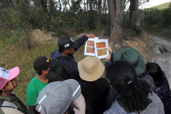
12 July 2024, Moramanga - The Food and Agriculture Organization of the United Nations (FAO) organized a national workshop in Moramanga, Madagascar, to support data collection for the Remote Sensing Survey (RSS) of FAO’s 2025 Global Forest Resources Assessment (FRA). Thirteen experts attended the workshop from 8 to 12 July 2024, which was organized with the financial support of the European Union and the Government of Norway.
The workshop provided an overview of the FRA 2025 RSS methodology and clarified its terms and definitions. The facilitators gave participants an introduction to the physics of remote sensing, explained the theory behind photointerpretation of satellite images and clarified how to use the Collect Earth Online (CEO) application. Furthermore, the participants had the opportunity to compare satellite images of national samples from the FRA 2025 RSS with the actual conditions on the ground in the Andasibe-Mantadia National Park to ground truth the image interpretation.
Monitoring other wooded land in Madagascar
Madagascar is home to one of the richest biodiversity on the planet, characterized by a high level of endemism and divided into different ecosystems. Madagascar's vegetation is extremely varied, including dense tropical rainforest of the east coast, grassy savannahs and desert areas, mangroves of the west coast and the tropical dry forest of the south and south-west.
In 2020, forests covered 21 percent of Madagascar's land area. Twenty-four percent of this area was classified as other wooded land, defined as land not considered forest that covers more than 0.5 hectares with trees more than 5 meters high and tree cover of 5 to 10 percent or with a combined cover of shrubs, bushes and trees of more than 10 percent. Certain types of vegetation in Madagascar, in particular certain thorny thickets or shrubby savannahs, fall into this category. However, a significant decline in other wooded land areas were observed in the country between 2000 and 2018.
This decline in other wooded land is linked to the heavy anthropization of certain areas of the country, but may also be linked to the complexity of monitoring this type of vegetation. It is difficult to reliably identify land with low tree cover or to see the height of trees on satellite images. To refine the analysis of the images, knowledge of the ecology and land use of the areas studied is essential. Madagascar's experts are in the best position to identify these areas based on their knowledge of the terrain and landscape features.
FAO’s global Remote Sensing Survey
Since 1948, FAO has conducted assessments of the condition, extent, management and uses of global forest resources. The assessments compile comprehensive country reports every five years from officially nominated FRA national correspondents with a standardized methodology to inform the decisions and recommendations of civil society, the private sector, governments and international conventions.
The Remote Sensing Survey, developed in 1990, is used by FRA to assess the status and changes in forest area and other key land uses at global, regional and biome levels with satellite imagery and remote sensing tools. The FRA 2025 RSS will update data on variables from the previous cycle up to the year 2023 and collect new information on agroforestry systems, pastoral systems, types of crops, burned forests, mangroves and trees outside of forests. Reliable, up-to-date data is essential for implementing sustainable forest management that protects the ecosystem services essential to local communities and biodiversity in the region.
Learn more
- Interactive story: A fresh perspective
- Platform: FRA 2020 data
- Publication: FRA 2020 Remote Sensing Survey
- Publication: FRA 2020 main report
- Website: Remote Sensing | Global Forest Resources Assessment
- Video: Insight into the Global Forest Resources Assessment process