Noticias
En esta sección se presentan artículos y noticias sobre las actividades que lleva a cabo la FAO con apoyo de tecnología y métodos geoespaciales.
07 February 2025
The Food and Agriculture Organization of the United Nations (FAO) and the United Nations Office for Outer Space Affairs (UNOOSA) will launch their latest collaborative effort, the publication “Leveraging Space Technology for Agricultural Development and Food Security.”
You are kindly invited...
31 January 2025

The ceasefire is the first step in delivering emergency relief and rebuilding local food production in the Gaza Strip, where more than 2 million people urgently need assistance due to the collapse of agricultural output, according to the Food and...
06 December 2024

The SoilFER Geospatial Platform was officially launched on December 5th at UNCCD COP16. This open-access platform offers comprehensive geographic information on the suitability of opportunity crops identified by the Vision for Adapted Crops and Soils (VACS). By integrating detailed data...
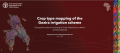
Sudan's ongoing conflicts have severely compromised agriculture, making a clear understanding of crop cultivation disruptions during this period crucial for addressing the current crisis and building future agricultural resilience.
This analysis focuses on the Gezira Irrigation Scheme, one of the largest...
10 July 2024

The Geospatial Knowledge, Innovation and Technology (GeoKIT) Network of FAO Americas organized a GeoKIT Talks series webinar on Agro-Ecological Zoning (AEZ) for crop yield and yield gap assessment for project formulation and implementation.
The Food and Agriculture Organization of the United...