Publications
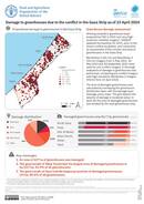
Utilising a baseline greenhouse layer prepared by FAO in 2021 and very high-resolution satellite imagery*, UNOSAT updated the baseline for 2023, prior to the recent conflict escalation, and conducted an assessment of the number and...
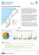
Crop type map of the Gaza Strip 2023
12 June 2024
12 June 2024
FAO and UNOSAT have conducted a series of geospatial assessments of agricultural land and infrastructure to assess damage due to the conflict in the Gaza Strip. Monitoring crops using remote sensing facilitates a greater understanding...

A cropland mask was prepared using very high-resolution satellite data from SPOT and Pléiades and high-resolution data from Sentinel-2 to analyse the damage to cropland. Sentinel-2 data from the month of May from 2017 to...
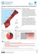
A cropland mask was prepared using very high-resolution satellite data from SPOT and Pléiades and high-resolution data from Sentinel-2 to analyse the damage to cropland. Sentinel-2 data from the month of May from 2017 to...
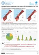
A cropland category mask was prepared using very high-resolution satellite data from SPOT and Pléiades and highresolution data from Sentinel-2 to analyse the damage to cropland. Sentinel-2 data from the month of May from 2017...