Publications
NDVI (Normalized Difference Vegetation Index) analysis is useful for wheat mapping and monitoring food security in Afghanistan, as it is a country that heavily relies on agriculture. In the framework of Afghanistan Emergency Food Security...

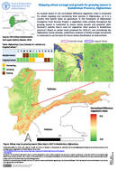
Monitoring and assessing agricultural drought is crucial for ensuring food security in Afghanistan. This assessment utilizes remote sensing data and analysis to evaluate drought extent using the vegetation health index1 which combines the vegetation and...

Geospatial assessments in Cabo Delgado and Nampula provinces, Mozambique, support land availability, accessibility, and use for IDPs, returnees, and host communities. A Google Earth Engine (GEE) App is being created for dynamic visualization, aiding informed...
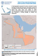
A rapid geospatial assessment has been conducted to assess the extent of loose sand and dunes in the eastern province of the Kingdom of Saudi Arabia. Sentinel–2 images were used to detect the loose sand...

The agroecological zones (AEZ) methodology, developed by the Food and Agriculture Organization of the United Nations (FAO) and the International Institute for Applied Systems Analysis (IIASA), is a well-established modelling system for land evaluation to...