Publications

Spatio-temporal dynamics of air pollution and the delineation of hotspots in the Lao People's Democratic Republic
20 March 2023
20 March 2023
In this report, the air pollution dynamics of the Lao People’s Democratic Republic are investigated given its increasing industrial and economic development, and the employment of frequent biomass burning as an agricultural practice. The Lao...
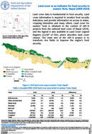
Land cover data is fundamental to food security. Land cover information is required to monitor food security indicators, and provide information on access to water, cropping intensities and many others. Land cover for eastern Terai...
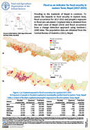
Flooding in the lowlands of Nepal is common. To assess the hazards to food security in eastern terai, flood occurrence for 2017-2022 and people’s exposure to flood are calculated. Cropland data is obtained from the...

Land degradation status for improving crop value chain in eastern Bhutan (2001-2015)
27 February 2023
27 February 2023
To measure the status of land degradation for improving crop value chain in eastern Bhutan, land degradation status map in the baseline period (2000-2015) was prepared using Landsat 4, Landsat 5 and Landsat 8 satellite...
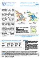
Land degradation assessment of Alto Hama, Angola
27 February 2023
27 February 2023
Assessments of land degradation have been conducted using Landsat and MODIS data for Alto Hama commune in Huambo province of Angola following the good practice guidance v2 of the UNCCD. The SEPAL SDG 15.3.1 module...