Publications
A cropland category mask was prepared using very high-resolution satellite data from SPOT and Pléiades and highresolution data from Sentinel-2 to analyse the damage to cropland. Sentinel-2 data from the month of May from 2017...
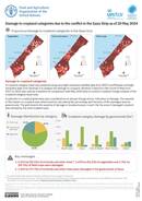
FAO has conducted a series of periodic geospatial assessments of agricultural land and infrastructure to assess damage due to the ongoing conflict in the Gaza Strip. GPS coordinates provided by FAOPAL were assessed and used...
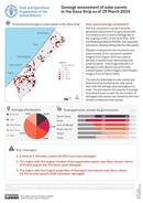
FAO and UNOSAT have conducted a series of geospatial assessments of agricultural land and infrastructure to assess damage due to the conflict in the Gaza Strip. Cropland category maps will facilitate assessments of damage to...
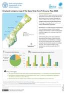
FAO and UNOSAT have conducted a series of geospatial assessments of agricultural land and infrastructure to assess damage due to the conflict in the Gaza Strip. Cropland category maps will facilitate assessments of damage to...
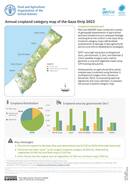
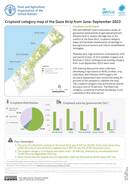
FAO and UNOSAT have conducted a series of geospatial assessments of agricultural land and infrastructure to evaluate damage resulting from the conflict in the Gaza Strip. Cropland category maps will facilitate assessments of damage to...