Publications

Land degradation assessment of Alto Hama, Angola
16 February 2023
16 February 2023
A land degradation assessment has been conducted for Alto Hama commune in Huambo province, Angola. A land cover legend was prepared using LCML/LCCS v3 based on key degradation processes identified in the area. Land cover...
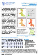
Land degradation assessment of Chipipa, Angola for 2001-2015, 2015-2018 and 2018-2021
16 February 2023
16 February 2023
A land degradation assessment has been conducted for Chipipa commune in Huambo province, Angola. A land cover legend was prepared using LCML/LCCS v3 based on key degradation processes identified in the area. Land cover maps...
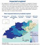
A rapid geospatial analysis of the flood impacts on crops in Eastern Cape province of South Africa in 2022
10 February 2023
10 February 2023
An analysis to assess the impacts of floods on cropland in Eastern Cape province was performed using existing data, GIS and remote sensing. The crop mask was derived from the South African National Land...
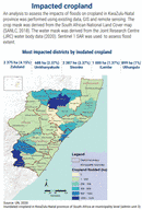
A rapid geospatial analysis of the flood impacts on crops in KwaZulu-Natal province of South Africa in 2022
10 February 2023
10 February 2023
An analysis to assess the impacts of floods on cropland in KwaZulu-Natal province was performed using existing data, GIS and remote sensing. The crop mask was derived from the South African National Land Cover...
Agro-Ecological Zoning (AEZ) framework was developed as a tool to analyse the effect of climate on land use and agricultures, as well as helping to optimise the crop cycle to produce the best yield possible....