Publications
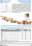
Indicator for people’s vulnerability to cropland water insecurity in Eastern Terai, Nepal (2022)
30 January 2023
30 January 2023
To assess potential priority areas for improving access to water for rice production in eastern Terai, rainfed and irrigated cropland were mapped at 5m spatial resolution (using 2022 Planet, Sentinel–1, Sentinel–2 and vegetation index using...
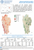
Maximum potential rice yield in Mizoram, India
24 January 2023
24 January 2023
In support of the GreenAg project (GCP/IND/183/GEF), the maximum potential annual rice yield was calculated for Mizoram state, India. The assessment was carried out using a free and open package for agro-ecological zoning (PyAEZ)1, 2012-2021...
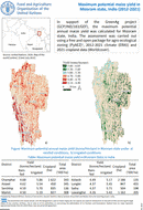
Maximum potential maize yield in Mizoram, India
24 January 2023
24 January 2023
In support of the GreenAg project (GCP/IND/183/GEF), the maximum potential annual maize yield was calculated for Mizoram state, India. The assessment was carried out using a free and open package for agro-ecological zoning (PyAEZ)1, 2012-2021...
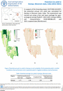
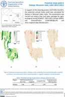
Potential rice yield in Dampa, Mizoram
24 January 2023
24 January 2023
In support of the GreenAg project (GCP/IND/183/GEF), the potential annual rice yield was calculated for Dampa in Mizoram state, India. The assessment was carried out using a free and open package for agroecological zoning (PyAEZ)1,...
Potential maize yield in Dampa, Mizoram
24 January 2023
24 January 2023
In support of the GreenAg project (GCP/IND/183/GEF), the potential annual maize yield was calculated for Dampa in Mizoram state, India. The assessment was carried out using a free and open package for agroecological zoning (PyAEZ)1,...