Publications
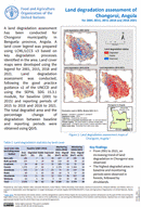
Land degradation assessment of Chongoroi , Angola for 2001 2015, 2015 2018 and 2018 2021
13 January 2023
13 January 2023
A land degradation assessment has been conducted for Chongoroi municipality in Benguela province, Angola. A land cover legend was prepared using LCML/LCCS v3 based on key degradation processes identified in the area. Land cover...
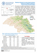
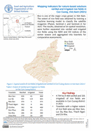
Mapping indicators for nature-based solutions rainfed and irrigated croplands in Thanh Chuong, Viet Nam (2021)
11 January 2023
11 January 2023
The extent of cropland was prepared in support to nature-based solutions (NBS) indicator monitoring in Viet Nam, which was obtained by training a machine learning model to classify the satellite imageries (Planet, Sentinel–1 and Sentinel–2)...
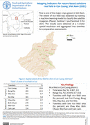
Mapping indicators for nature-based solutions rainfed and irrigated croplands in Con Cuong, Viet Nam (2021)
11 January 2023
11 January 2023
The extent of cropland was prepared in support to nature-based solutions (NBS) indicator monitoring in Viet Nam, which was obtained by training a machine learning model to classify the satellite imageries (Planet, Sentinel–1 and Sentinel–2)...
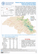
Rainfed and irrigated rice fields in Thanh Chuong, Vietnam
11 January 2023
11 January 2023
Rice is one of the major crops grown in Viet Nam. The extent of the rice field was obtained by training a machine learning model to classify the satellite imageries (Planet, Sentinel–1 and Sentinel–2) for...
Rainfed and irrigated rice fields in Con Cuong, Vietnam
11 January 2023
11 January 2023
Rice is one of the major crops grown in Viet Nam. The extent of rice field was obtained by training a machine learning model to classify the satellite imageries (Planet, Sentinel–1 and Sentinel–2) for 2021....