Publications
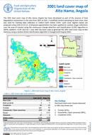
2001 land cover map of Alto Hama, Angola
05 January 2023
05 January 2023
The 2001 land cover map of Alto Hama, Angola has been developed as part of the process of land degradation assessment in the area from 2001 to 2021. A stratified random sampling by land cover...
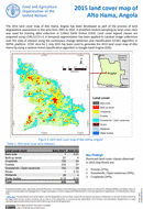
2015 land cover map of Alto Hama, Angola
05 January 2023
05 January 2023
The 2015 land cover map of Alto Hama, Angola has been developed as part of the process of land degradation assessment in the area from 2001 to 2021. A stratified random sampling by land cover...
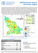
2018 land cover map of Alto Hama, Angola
05 January 2023
05 January 2023
The 2018 land cover map of Alto Hama, Angola has been developed as part of the process of land degradation assessment in the area from 2001 to 2021. A stratified random sampling by land cover...
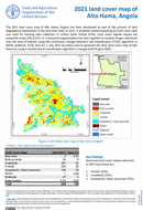
2021 land cover map of Alto Hama, Angola
05 January 2023
05 January 2023
The 2021 land cover map of Alto Hama, Angola has been developed as part of the process of land degradation assessment in the area from 2001 to 2021. A stratified random sampling by land cover...
Python Package for Agro-ecological zoning
01 January 2023
01 January 2023
PyAEZ is a python package consisting of several algorithms related to the Agro-ecological zoning (AEZ) framework. PyAEZ attempts to encapsulate all complex calculations available in AEZ and provide a user-friendly and intuitive interface for data...