Publications
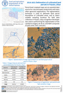
Parcel-level cropland maps are an essential data source for crop and water productivity and many other agronomy applications. The segmentation technique is used to delineate land parcel boundaries of cultivated areas, and to select suitable...
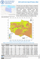
2022 Land cover map of Fezzan, Libya
30 December 2022
30 December 2022
The land cover map (2022) of Fezzan is prepared to support decision making to improve crop and water productivity. The training data of various land cover classes collected using high resolution imageries and trained using...
Libya is characterized by water scarcity. The land cover map is required to support crop and water productivity in Libya. Sampling design needs to be carried out to identify suitable locations for field surveys to...
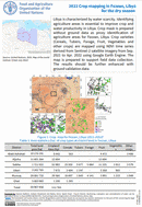
2022 Crop mapping in Fezzan, Libya for the dry season
30 December 2022
30 December 2022
Libya is characterized by water scarcity. Identifying agriculture areas is essential to improve crop and water productivity in Libya. Crop mask is prepared without ground data as proxy identification of agriculture areas for Fezzan,...
The Forest and Farm Facility (FFF)1 in Nepal focuses on strengthening the capacities of forest and farm producer organizations (FFPOs) to ensure inclusive governance and strategic intervention in policy dialogue through advocacy, business incubation...