Publications
A geospatial assessment of the impact of flood in support to the restoration of irrigation schemes in Malawi
20 December 2022
20 December 2022
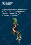
The southern and central provinces in Malawi are vulnerable to extreme weather events such as floods and droughts. Over 75% of the irrigated land in the Southern region of the country is located in Nsanje...
Crop type mapping in East Jabalia North Gaza, Palestine for the summer season (2022)
19 December 2022
19 December 2022
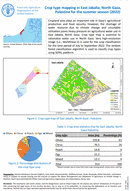
Cropland area plays an important role in Gaza's agricultural production and food security. However, the shortage of water resource due to climate change and unsuitable utilization poses heavy pressure on agricultural water use in East...
Land cover map of East Jabalia North Gaza, Palestine
19 December 2022
19 December 2022
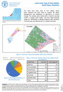
The 2021 land cover map of East Jabalia, North Gaza, Palestine has been done to support the Water Management and Adaptation of Agriculture to climate change. The samples were trained with a machine learning model...

Land cover map of Pupuan, Indonesia, 2021
19 December 2022
19 December 2022
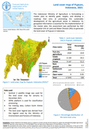
The Indonesian Ministry of Agriculture is formulating a master plan to identify goals, targets, and develop a roadmap that aims at promoting the sustainable development of the agricultural sector in Indonesia. As geospatial information is...
Land cover map of Pupuan, Indonesia, 2021
19 December 2022
19 December 2022
The Indonesian Ministry of Agriculture is formulating a master plan to identify goals, targets, and develop a roadmap that aims at promoting the sustainable development of the agricultural sector in Indonesia. As geospatial information is...