Publications
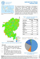
Land cover map of Sleman, Indonesia, 2021
19 December 2022
19 December 2022
The Indonesian Ministry of Agriculture is formulating a master plan to identify goals, targets, and develop a roadmap that aims at promoting the sustainable development of the agricultural sector in Indonesia. As geospatial information is...
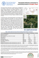
A monitoring system is being operationalized to track progress of the FFF efforts using geospatial technologies. The results for selected FFF geospatial indicators are presented for the community forests in Bungdal (Figure 1) where...
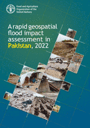
A Rapid Geospatial flood impact assessment in Pakistan 2022
14 December 2022
14 December 2022
In 2022, intense rainfall in monsoon season caused severe flooding across Pakistan and impacted a large number of people and households including deaths of people, damages of infrastructure (including roads, dams, buildings, electricity poles...
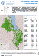
Cropland in Central and Southern provinces, Malawi (2022)
17 October 2022
17 October 2022
Cropland data for Central and Southern provinces ofMalawi for 2022 was prepared to assess the impactsof flooding from tropical storms from January to March 2022. A 10-metre cropland extent data was prepared using monthly composites...