Publications
Python Package for Agro-ecological zoning
17 October 2022
17 October 2022
PyAEZ is a Python package consisting of several algorithms related to the Agro-Ecological Zoning (AEZ) framework. PyAEZ attempts to encapsulate all complex calculations available in AEZ and provide a user-friendly and intuitive interface for data...
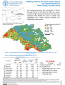
Mapping indicators for nature-based solutions net evapotranspiration in Thanh Chuong, Vietnam (2021)
10 October 2022
10 October 2022
Net evapotranspiration was calculated in ThanhChuong district in Viet Nam for 2021 as a proxymeasure of agricultural productivity. The data wasobtained from MODIS for 2021 at 500m andaggregated into Thanh Chuong townlets for comparative assessment....
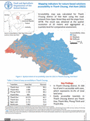
Mapping indicators for nature-based solutions accessibility in Thanh Chuong, Vietnam (2022)
10 October 2022
10 October 2022
Accessibility map was calculated for ThanhChuong district of Viet Nam using the roadnetwork from Open Street Map and the slope fromSRTM. The result was obtained at the spatial resolution of 30 meters and aggregated at...

Mapping indicators for nature-based solutions accessibility in Con Cuong, Vietnam (2022)
10 October 2022
10 October 2022
Accessibility map was calculated for Con Cuongdistrict of Viet Nam using the road network fromopen street map and the slope from SRTM. Thedata is obtained at spatial resolution of 30 metersand aggregated at townlets level...

Mapping indicators for nature-based solutions tree cover change in Thanh Chuong, Vietnam (2001-2020)
10 October 2022
10 October 2022
Tree cover change was obtained from global forest cover change1 to assess the gain and loss of treesin Thanh Chuong district of Viet Nam. Theassessment was done from 2001 to 2020 at aspatial resolution of...