Publications
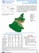
Mapping indicators for nature-based solutions tree cover change in Con Cuong, Vietnam (2001-2020)
10 October 2022
10 October 2022
Tree cover change is obtained from global forest cover change1 to assess the gain and loss of treesin Con Cuong district of Viet Nam. The assessment was done from 2001 to 2020 at a spatial...

Mapping indicators for nature-based solutions soil moisture in Thanh Chuong, Vietnam (2021)
10 October 2022
10 October 2022
Soil moisture is obtained from Sentinel 1 to assessthe proxy for water availability in soil; which can alsobe used as a proxy to calculate crop yield, cropproductivity, water stress and drought in a region. The...
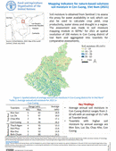
Mapping indicators for nature-based solutions soil moisture in Con Cuong, Vietnam (2021)
10 October 2022
10 October 2022
Soil moisture is obtained from Sentinel 1 to assessthe proxy for water availability in soil; which canalso be used to calculate crop yield, cropproductivity, water stress and drought in a region. The assessment was made...
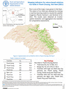
Mapping indicators for nature-based solutions rice fields in Thanh Chuong, Vietnam (2021)
10 October 2022
10 October 2022
Rice is one of the major crops grown in Viet Nam. The extent of rice field was obtained by traininga machine learning model to classify the satelliteimageries (Planet, Sentinel 1 and Sentinel 2) for2021. The...
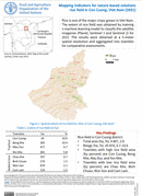
Mapping indicators for nature-based solutions rice field in Con Cuong, Vietnam (2021)
10 October 2022
10 October 2022
Rice is one of the major crops grown in Viet Nam. The extent of rice field was obtained by traininga machine learning model to classify the satelliteimageries (Planet, Sentinel 1 and Sentinel 2) for2021. The...