Publications

Mapping indicators for nature-based solutions soil organic carbon of Thanh Chuong, Vietnam
10 October 2022
10 October 2022
To measure the land degradation (SDG 15.3.1) inThanh Chuong district of Viet Nam, soil organiccarbon (input data to SDG 15.3.1) at 0-30 cm depthwas derived from Soilgrid. The data were obtainedat 250m spatial resolution and...
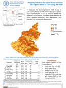
Mapping indicators for nature-based solutions soil organic carbon of Con Cuong, Vietnam
10 October 2022
10 October 2022
To measure the land degradation (SDG 15.3.1) inCon Cuong district of Viet Nam, soil organic carbon(input data to SDG 15.3.1) at 0-30 cm depth wasobtained from Soilgrid. The data were obtained at 250m spatial resolution and...

Mapping indicators for nature-based solutions net primary productivity in Thanh Chuong, Vietnam (2021)
10 October 2022
10 October 2022
To measure the land degradation (SDG 15.3.1) in Thanh Chuong district of Viet Nam, annual net primary productivity (NPP) (input data to SDG15.3.1) of 2021 was obtained from MODIS. The data were obtained at...

Mapping indicators for nature-based solutions net primary productivity in Con Cuong, Vietnam (2021)
10 October 2022
10 October 2022
To measure the land degradation (SDG 15.3.1) inCon Cuong district of Viet Nam, annual net primaryproductivity (NPP) (input data to SDG 15.3.1) of 2021 was obtained from MODIS. The data wereobtained at 500 m spatial...

Mapping indicators for nature-based solutions status of land degradation in Thanh Chuong, Vietnam (2016-2021)
10 October 2022
10 October 2022
The land degradation (SDG 15.3.1) was measured inThanh Chuong district of Viet Nam for the period2016-2021 to provide support for deriving thenature-based solutions indicators. The assessmentwas carried on SDG 15.3.1 module of SEPAL1andthe results were...