Publications

Mapping indicators for nature-based solutions cropland exposed to high, medium, low flood in Con Cuong, Vietnam (2017-2021)
10 October 2022
10 October 2022
Cropland exposed to flooding frequency (low, medium and high) was calculated in Con Cuongdistrict of Viet Nam to assess the potential impact of flood on cropland and agriculture productionfor the period 2017-2021. Flooding frequency wascalculated...
Mapping indicators for nature-based solutions forest fragmentation in Thanh Chuong, Vietnam (2021)
10 October 2022
10 October 2022
Forest fragmentation was calculated in Thanh Chuongdistrict of Viet Nam for 2021. The calculation wasperformed using GWB Analysis (Frag) app of SEPAL1platform. Average-per-patch (APP) of forest areadensity (FAD) was calculated through an average ofsquare neighborhood...

Mapping indicators for nature-based solutions forest fragmentation in Con Cuong, Vietnam (2021)
10 October 2022
10 October 2022
Forest fragmentation was calculated in Con Cuongdistrict of Viet Nam for 2021. Calculation wasperformed using GWB Analysis (Frag) app of SEPAL1 platform. Average-Per-Patch (APP) of forest area density (FAD) was calculated throughan average of square...

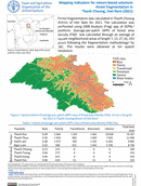
Mapping indicators for nature-based solutions cropland exposed to high, medium, low flood in Thanh Chuong, Vietnam (2017-2021)
10 October 2022
10 October 2022
Cropland exposed to flooding frequency (low, medium and high) was calculated in Con Cuong district of Viet Nam to assess the potential impact of flood on cropland and agriculture production for the period 2017-2021. Flooding...

Flood impacted irrigated cropland area in Central and Southern provinces, Malawi (2022)
08 October 2022
08 October 2022
Cropland for Central and Southern provinces of Malawi was prepared to assess the impacts of flooding from tropical storms from January to March 2022. The cropland data was labeled into irrigated and rainfed using...