Publications
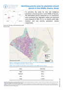
To prioritize the areas for tree and hedgerow plantation around parcels in Jimo Midlle of Kisumu, the delineated parcels (obtained at 5 m resolution) were overlayed over degraded, stable and improved area (measure of SDG...

To support Green Cities Initiative project through decision support in implementing activities at maintaining freshwater ecosystem in Lake Victoria, the extent of water invasive species in Kisumu, Kenya is calculated between 2016 to 2020. Results...
Identifying priority areas for tree and hedgerow plantation around parcels in Kisumu, Kenya
15 March 2022
15 March 2022
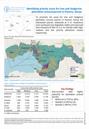
To prioritize the areas for tree and hedgerow plantation around parcels in Kisumu, Kenya the delineated parcels (obtained at 5 m resolution) were overlayed over degraded, stable and improved area (measure of SDG 15.3.1),...
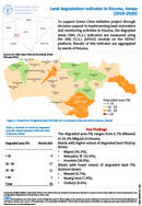
To support Green Cities Initiative project through decision support in implementing land restoration and monitoring activities in Kisumu, the degraded areas (SDG 15.3.1 indicator) are measured using the SDG 15.3.1 (GPGv2) module on the SEPAL1...
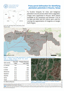
To localize hotspots for trees and hedgerow plantation around parcels where land is degraded, images were segmented in Kisumu. NICFI planet (available at 5m resolution) and Sentinel 1 (at 10 m) data and NDVI...