Publications
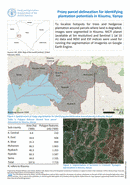
To localize hotspots for trees and hedgerow plantation around parcels where land is degraded, images were segmented in Kisumu. NICFI planet (available at 5m resolution) and Sentinel 1 (at 10 m) data and NDVI...
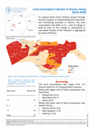
To support Green Cities Initiative project through decision support in implementing land restoration and monitoring activities in Kisumu, the land consumption rate (SDG 11.3.1 – ratio of change in built-up area to the change...

To support Green Cities Initiative project through decision support in implementing land restoration and monitoring activities in Kisumu, the degraded areas (SDG 15.3.1 indicator) is measured using the SDG 15.3.1 (GPGv2) module on the...

To measure land degradation (SDG 15.3.1), annual Net Primary Productivity (NPP) (input data to SDG 15.3.1) of 2020 was obtained from MODIS for Kisumu, Kenya. The data were obtained at 500 m spatial resolution...
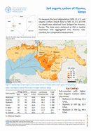
Soil organic carbon of Kisumu, Kenya
08 March 2022
08 March 2022
To measure the land degradation (SDG 15.3.1), soil organic carbon (input data to SDG 15.3.1) at 0-30 cm depth was obtained from Soilgrid for Kisumu, Kenya. The data were obtained at 250 m spatial...