Publications
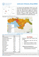
Land cover of Kisumu, Kenya (2016)
07 March 2022
07 March 2022
To measure land degradation (SDG 15.3.1), the land cover (input data to SDG 15.3.1) is generated using the 2008 Africover legend for Kisumu, Kenya. The samples were trained with a machine learning model in...
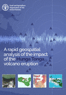
On the 15th January 2022 the underwater Hunga Tonga–Hunga Haʻapai volcano, located in the north of Tongatapu (the main island of Tonga), erupted following several minor eruptions over the previous weeks. It was reported...
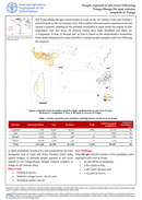
The Tonga-Hunga Ha'apai volcano began to erupt on the 14th January 2022 and reached a powerful peak on the 15th January 2022. The eruption released massive amounts of ash and caused a tsunami, resulting...
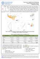
Impacts on cropland due to flooding following Tonga-Hunga Ha’apai volcano eruption in Tonga
22 February 2022
22 February 2022
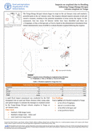
The Tonga-Hunga Ha'apai volcano began to erupt on the 14th January 2022 and reached a powerful peak on the 15th January 2022. The eruption released massive amounts of ash and caused a tsunami, resulting...
The Tonga-Hunga Ha'apai volcano began to erupt on the 14th January 2022 and reached a powerful peak on the 15th January 2022. The eruption released massive amounts of ash and caused a tsunami, resulting...