Publications
Harmonized World Soil Database version 2.0
28 January 2022
28 January 2022
The Harmonized World Soil Database version 2.0 (HWSD v2.0) is a unique global soil inventory providing information on the morphological, chemical and physical properties of soils at approximately 1 km resolution. Its main objective is...
Terms of Reference for Advisory Group on Land Cove and Land Use
05 December 2021
05 December 2021
Revised Terms of Reference
ISO TC211 Advisory Group 13 on Land Cover Land Use
2 February 2021
The classification of land cover and land use are some of the primary measures driving climate science and
are critical for addressing many...
Geospatial information is essential for planning relief and/or restoration interventions as well as to advocate for intervention and define priorities/needs. This rapid assessment complements a first rapid assessment conducted on 28 May 2021 and...
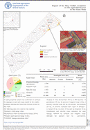
A rapid geospatial analysis was undertaken to estimate the damages to land and crops caused by the conflict escalation affecting the Gaza Strip between 10 and 21 May 2021.
The following data were used for this...
Register implementation for land cover legends
12 August 2021
12 August 2021
Land cover assessment and monitoring of its dynamics are essential requirements for the sustainable management of natural resources, environmental protection, food security, humanitarian programmes as well as core data for monitoring and modelling. Land Cover...