Publications
Proceedings of the virtual event Geospatial for sustainable agriculture and urban development
15 January 2023
15 January 2023
To improve knowledge sharing on the use of geospatial technologies in support to sustainable urban and agricultural development, the virtual event “Geospatial for Sustainable Agriculture and Urban Development” was organized on September 15, 2022. This...
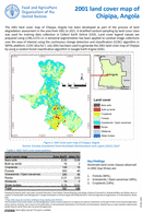
2001 land cover map of Chipipa, Angola
13 January 2023
13 January 2023
The 2001 land cover map of Chipipa, Angola has been developed as part of the process of land degradation assessment in the area from 2001 to 2021. A stratified random sampling by land cover class...
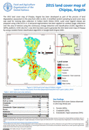
2015 land cover map of Chipipa, Angola
13 January 2023
13 January 2023
The 2015 land cover map of Chipipa, Angola has been developed as part of the process of land degradation assessment in the area from 2001 to 2021. A stratified random sampling by land cover class...
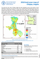
2018 land cover map of Chipipa, Angola
13 January 2023
13 January 2023
The 2018 land cover map of Chipipa, Angola has been developed as part of the process of land degradation assessment in the area from 2001 to 2021. A stratified random sampling by land cover class...

2021 land cover map of Chipipa, Angola
13 January 2023
13 January 2023
The 2021 land cover map of Chipipa, Angola has been developed as part of the process of land degradation assessment in the area from 2001 to 2021. A stratified random sampling by land cover class...