Land Resources Information Management Systems (LRIMS)
Land information is a pre-requisite for making decisions related to land investment, development and management. Information also reduces uncertainty by helping to identify and analyse problems. The objective of the Land Resources Information and Management Systems (LRIMS) is to create a secure, reliable, efficient, accountable and equitable system of management of land resources related to agriculture.
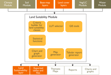
LRIMS comprises a comprehensive set of GIS-Based tools, boasts a central spatial database, and provides evaluation of land-use suitability based on modular multiple criteria analysis-based assessment, including a Socio-Agricultural Vulnerability Analysis (SAVA). LRIMS allows assessments of the physical/socio-economic conditions of the land to be undertaken and the evaluation of the benefits and constraints of different options through the simulation of various impact scenarios. LRIMS can act as the central repository for the information required to assess vulnerability and calculate risk, through the development of an Agro-Ecological Zoning (AEZ) analysis of land use and crop suitability to match with changing climatic conditions and agricultural management. Collated geospatial data on climate (and future climatic scenarios), topography, soil and production systems along with impact and vulnerability scenarios, represents an essential tool to understand climate impacts on cropping systems and guide policy-makers in developing climate responsive policies and plans and providing location-specific adaptation options for farmers.

