Panama
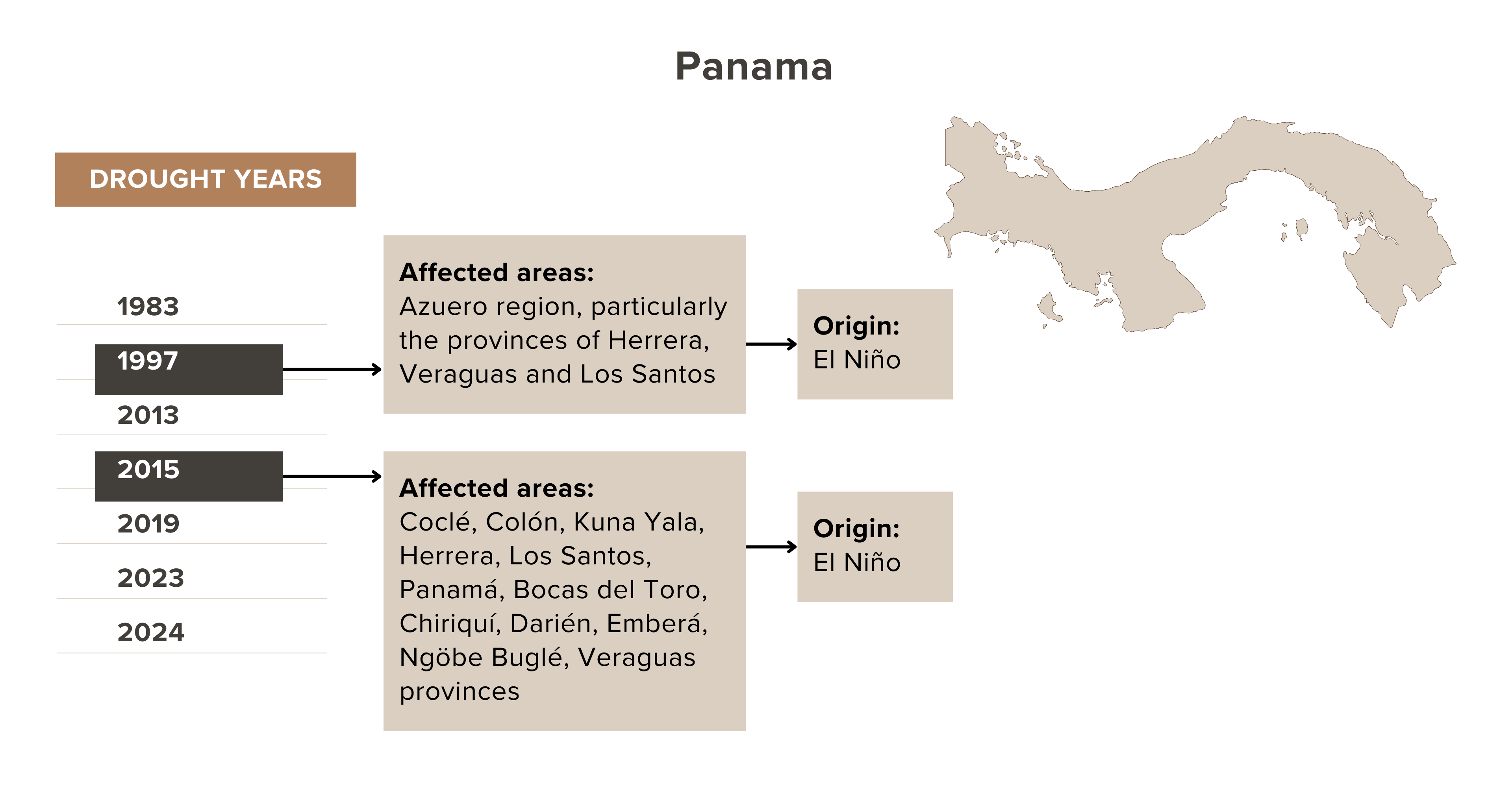
HISTORICAL DROUGHT – Panama is located in Central America, with Colombia positioned in the country’s east and Costa Rica in the west. In Panama’s north is the Caribbean Sea, while the Pacific Ocean is located on its southern coast. Drought events in Panama are generally related to the El Niño phenomenon that typically occurs in the later months of the year. The usually affected areas are the Arco Seco region, the Veraguense savanna, Cerro Punta, and the Ngöbe Buglé shire.
In recent years, drought events have affected the Panama Canal Hydrographic Basin. The 2019 drought was classified as severe and affected the water level in the Panama Canal. Likewise, the 2023–2024 drought was considered the worst drought in over 70 years, wherein rainfall was 43% lower than average level. This caused the Panama Canal to experience its lowest water levels in history.

DROUGHT IMPACT PATHWAY – In Panama, drought severely impacts agriculture, energy, water utility, and transportation sectors, especially maritime transport. The Panama Canal, operated and managed by State authorities, is a vital transit passage to global trade. The impact of drought on the water level in the canal disrupts maritime transport operations, leading to significant interruption in the global supply chain. Disruptions in maritime operations also reduce government revenues from transport transactions. Severe and prolonged drought events also have dangerous impacts on the population's welfare in terms of food security, especially that of the subsistence farmers, and the availability of water for drinking and sanitation.
.png?sfvrsn=98b3ca4a_1)
Highlights of drought vulnerability dimensions
- 4.4 million population, of which 30.9% are in rural areas (2022).
- Poverty in rural areas rose from 29.3% in 2022 to 32.3% in 2023.
- 76% of indigenous population in Panama lives in rural areas.
- 3 indigenous autonomous comarcas, Comarca Guna Yala, Comarca Embera, and Comarca Ngobe-Bugle, registered the highest poverty rates at USD 3.65 and USD 6.85 (2017 PPP) (2021); they are also the most rural areas in the country.
- Indigenous groups have the most inadequate access to basic services in rural areas.
- 81.0%, 95.4%, and 99.3% of children ages 0 to 17 were considered poor in comarcas Emberá Wounaan, Ngäbe-Buglé, and Guna Yala, respectively.
- More than 80% of third-grade children in the 3 comarcas do not know how to read or do not understand the content, compared to 51% nationwide.
- Women and girls aged 15+ spend 18% of their time on unpaid care and domestic work, compared to 7.6% spent by men.
- Agriculture’s share of GDP is 2.6% (2022).
- Employment in agriculture is 15.3% of total employment (2022).
- Loss of agricultural GDP by land degradation (as % of total agricultural GDP) is 12.4% (2013).
- Chiriquí province produces 80% of the national agricultural output.
- 40.1% of the labor force comprises women (2023).
- Female labor force participation rate is 50.3%, compared to male, 76.4% (2023).
- Rural population without incomes of their own: women, 30.6%; men, 10.0% (2022).
- Urban population without incomes of their own: women, 16.4%; men, 7.1% (2022).
- Economic participation of people in poverty: 35%, women; 64.7%, men (2022).
- Panama Canal accounts for 5%–6% of global shipping, so disruptions affect the worldwide supply chain, & it is the government’s important revenue source.
- Transport is vital to the service sector.
- Hydropower comprised 71% of Panama’s electricity generation (2021).
- The Panama Canal is an important infrastructure for global trade.
- Gatun dam supplies drinking water to millions of residents in the central region, including the two major cities of Panama City and Colón; it services half of Panama's population.
- Cochea Dam (15MW total capacity; 50GWh average annual energy), Concepción Dam (30MW total capacity; 158GWh average annual energy production), Las Cruces Dam (21MW total capacity; 109GWh average annual energy production) are used for hydropower generation.
- Panama has more than 17 hydropower plants.
- Total installed hydropower capacity in the country is 1,754 MW.
- Agricultural irrigated land (% of total agricultural land) is 1.9%.
- 86.1% of the rural population uses at least basic drinking water services, lower than 94.6% of the total population (2022).
- 66.4% of the rural population uses at least basic sanitation services, lower than 85.9% of the total population (2022).
- Competing use of the Gatun Lake water: water for drinking and water supply for Panama Canal
- Panama has several morpho-structural regions: mountains, low hills and hills, lowlands, and coastal plains
- The country is located in the tropical zone, with 32% of its land classified as tropical moist forest
- Panama has a warm and humid tropical climate, with temperatures in the coastal plains reaching 28° to 30°C, and 18°C or lower in the high mountains
- 50% of the total degraded area in Panama is concentrated in 4 basins: Tuira, Panama Bay Coast, Gulf Coast of Panama, San Blas Archipelago Coast
- Herrera, Los Santos, Veraguas, Coclé, and the Ngäbe-Buglé regions have significant areas with degraded soils, extensive livestock farming, and problems supplying services with surface water.
- Agricultural land comprises 29.4% of total land (2021).
- Panama developed the National Drought Plan for Panama in 2020 to improve drought risk management.
- Plans related to drought risk management, disaster risk reduction, climate change: National Action Program to Fight Desertification and Drought in Panama 2015 –2024, National Strategy for Climate Change 2050, National plan on climate change for agriculture, Economic and Social Development Plan - PDES 2021-2025, National Water Security Plan 2015- 2050, Integrated Water Resources Management National Plan 2010-2030.
- Institutional laws and regulations related to water, drought risk management, disaster risk reduction, climate change: Law 22 of November 15, 1982, Law No. 9 of January 3, 1996, General Law of the Environment of the Republic of Panama (1998), Law 24 of June 4, 2001, Law 7 of February 11, 2005, Executive Decree No. 35 - National Climate Change Policy, Executive Decree 177 of April 30, 2008, National Policy for Comprehensive Disaster Risk Management, Law 69/2017 creating an incentive programme for forest cover and the conservation of natural forests (2017).
- Government agencies relevant to drought risk management: National Environmental Authority, Ministry of environment, Water Security Directorate of the Ministry of Environment, National Committee to Fight Drought and Desertification, System National Civil Protection Agency (SINAPROC), National Civil Protection Council, Emergency Operations Center, National Committee on Climate Change in Panama, Ministry of Agricultural Development, Agricultural Research Institute of Panama, National Secretariat of Science and Technology, Hydrometeorology Directorate.
- SINAPROC is responsible for the execution of disaster prevention, mitigation, preparation, intervention and recovery policies and plans.
- Law 24 of June 4, 2001, established measures supporting agricultural producers affected by adverse weather conditions and created the Special Fund for Contingency Credits (FECC) that grant agricultural loans through the Agricultural Development Bank or the National Bank of Panama
Centre for Research on the Epidemiology of Disasters. 2024. In: Emergency Events Database EM-DAT. [Cited 2 April 2024]. https://www.emdat.be/
International Energy Agency. 2021. Climate Impacts on Latin American Hydropower. Paris.
Ruiz, S. & Shinatani, C. 2024. Drought in Panama is disrupting global shipping. Woodwell Climate Research Center. [Cited: 9 April 2024]. https://www.woodwellclimate.org/drought-panama-canal-7-graphics/
UN Women. 2024. Panama. In: UN Women. New York, USA, UN. [Cited 15 April 2024]. https://data.unwomen.org/country/panama
United Nations Educational, Scientific and Cultural Organization. 2020. Rurality and Education in Panama. Paris.
World Bank. 2023. In: Subnational Poverty and Inequality Database (SPID). [Cited 9 April 2024]. https://datacatalog.worldbank.org/search/dataset/0064796/subnational_poverty_and_inequality_database_spid
World Bank. 2024. In: World Bank Open Data. [Cited 9 April 2024]. https://data.worldbank.org/
FOCUS on Vulnerability
Economic sectors: Agriculture, maritime transportation, energy
Social groups: Subsistence farmers, agricultural communities, women in rural and urban areas, poor women, poor population especially in rural areas, indigenous population, children in comarcas
Geographical areas:
Arco Seco region, the Veraguense savanna, Cerro Punta, and Ngöbe Buglé shire, autonomous comarcas (Emberá Wounaan, Ngäbe-Buglé, Guna Yala), Chiriquí Province
