Kagera TAMP
The GEF-funded Transboundary Agro-ecosystem Management Project for the Kagera river basin (Kagera TAMP) (2009-2014) promoted an integrated ecosystems approach to land management that enhanced local, national and global benefits from ecosystem services. These benefits included restoration of degraded lands, carbon sequestration, climate change adaptation and mitigation, protection of international waters, agro-biodiversity conservation, sustainable use, and improved agricultural production. This aimed to increase food security and improve rural livelihoods in the watershed, covering Burundi, Rwanda, Tanzania and Uganda.
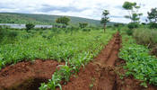
In Rwanda, the project was implemented in the Marebe catchment, Rulindo District. This catchment is representative of large areas of the basin with relateively steep slopes dominated by agriculture, and local farmers concerned by land degradation and reduced agricultural productivity.
Batchelor, J. and Birori, M. (2016) Assessing the hydrological impacts of sustainable management in the Kagera basin, documented the results from the project below:
Monitoring and Evaluation
Monitoring and Evaluation
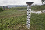
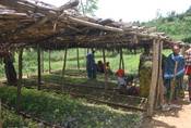
Participatory monitoring and evaluation through Farmer Field Schools (FFS), was used to collect hydrometric data such as stream flow, turbidity and rainfall on a daily basis. More intensive observations were made fro individual rain events over three rainy seasons. The WEPP hydrological model was used to simulate and model scenarios to investigate the potential impact, externalities and incentives required of different sustainable landscape management strategies.
Results
Results
Marebe catchment:
- Discharge in the Marebe catchment responds extremely quickly to rainfall
- The relationship between discharge and turbidity indicated that erosion was widespread across the catchment during rainfall events
- Expansion of the gully network due to deforestation and land degradation in the catchment is likely to have increased hydrogical connectivity and the speed at which runoff can enter stream channels
- Increased connectivity has also resulted in relatively rapid transport of eroded soil material from interfluvial areas to the stream channels and high turbidity levels well after the hydrograph peak
Benefits of sustainable landscape management:
- Rainwater harvesting structures could reduce runoff generated by small rainfall events
- Due to the early implementation of the project and study duration, some measures, such as the plantation of agroforestry trees and the adoption of practices such as mulching and no-tillage agriculture, had not fully established or become widespread
Scenario modelling:
- Indicated the potential impact that forest restoration could have in reducing runoff and erosion on steep slopes
- Suggested that a combination of multiple sustainable land management practices fully implemented across the entire catchment could reduce runoff and erosion, even for relatively large rainfall events
Negative externalities:
- Reduced downstream water availability caused by increased forest cover in upstream areas
Policy Recommendations
Policy Recommendations
- Marebe is a sub-catchment of the Yanze catchment which provides Kigali with the majority of its water supply. Prioritizing the restoration and protection of the watershed services in this area is therefore key.
- It will take time for many of the SLM components to become well established and to deliver significant benefits (hydrological and improved agricultural productivity). Implementation of SLM across Yanze catchment therefore requires long-term support to farmers, especially as some measures may have negative impacts on agricultural productivity and farmer incomes
- A PES scheme has been proposed by REMA (Rwanda Environment Management Authority) as one method to finance the implementation of SLM
- Negative externalities should be considered when implementing SLM plans, specifically possible reduced downstream flows as a result of widespread SLM
- The continued collection and analysis of hydrological data will be an essential component of an adaptive and evidence-informed approach to planning and implementing SLM and restoring watershed services