
Kagera Basin Land Degradation and Sustainable Land Management Assessment
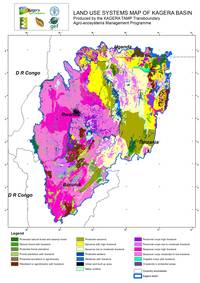
- Land Use Systems Map of the Kagera basin - click to enlarge

The Kagera TAMP project has used the LADA methodology to undertake an analysis of land degradation status, trend, causes and impacts. Also, the method has been used to analyse the existing SLM measures and their effectiveness and impacts.
Further to that, a geographical scale assessment of the LD and SLM is undertaken through the LADA-WOCAT Questionnaire for mapping.
The goal of this exercise is to obtain a picture of the distribution and characteristics of land degradation and conservation / SLM measures for a district, a province or the country. The final output are maps on the status, causes and impacts of land degradation as well as status and impact of conservation and SLM measures for major land use systems in the area.
The questionnaire is used as an evaluation tool for land degradation and SLM and multidisciplinary conservation activities undertaken in the provinces and by a team of land degradation and conservation specialists with different backgrounds and experiences, in consultation with the land users.
* All intellectual property rights, including copyright, in the work performed under the “Transboundary Agro-Ecosystem Management Programme for the Kagera River Basin” (thereafter referred as “Kagera TAMP”) shall be vested in FAO, including without any limitations, the right to use, publish, translate, sell or distribute, privately or publicly, any item or part thereof for non-commercial purposes. FAO hereby grants to the delegated institution of beneficiary country a non-exclusive royalty-free license to use, publish, translate and distribute, privately or publicly, any item or part of the work performed under Kagera TAMP for non-commercial purposes. Delegated institutions and distribution entities are mentioned in the national pages.