

Key achievements
The project has undertaken various Sustainable Land Management (SLM) interventions that aimed maintaining and enhancing agricultural productivity; minimising risks to agricultural, livestock and forestry production systems; protection of natural resources and prevention of environmental degradation; and improving livelihoods through increased income generating opportunities.
The intervention included activities by farmer groups in adopting Agroforestry systems; trials in Soil fertility improvement; construction and maintenance of Terraces; construction Rainwater harvesting dams; practicing appropriate agronomic techniques; and integrating livestock keeping with crop production.
Districts
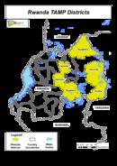
The project operates in four downstream and two upstream districts to the R. Kagera in the country. The downstream districts are Nyagatare, Kirehe, Kayonza and Bugesera in the Eastern province; with the upstream districts being Rulindo in the Northern and Kamonyi in the southern province. 11 micro catchments were identified basing on the severity of land degradation in the six districts as sites for project implementation. These are Karambo and Butare in Rulindo; Gasharu and Nyarurembo in Kamonyi; Gatebe II in Nyagatare; Kiyanja and Cyabajwa in Kayonza; Nyirarubomboza and Gakindo in Bugesera; and Muganza and Nyagasozi in Kirehe district.
SLM specific activities
Specific activities include:
- Planted 320,000 trees in all the catchments
- Constructed of 7 Ha of terraces in Karambo micro catchment
- Constructed 45 km of anti-erosion infiltration ditches in four micro catchments
- Put in place16 km of river buffer in three micro catchments
- Constructed water trapping pits with a combined capacity of 12,500 m3 in four micro catchments.
- Integrated soil fertility management trials and agronomic practices in 22 study plots with a combined area 10 Ha.
- Undertook livestock – crop activities in 8 micro catchments