Demand from agriculture: crop-mapping patterns to assess crop ET and water productivity
Results
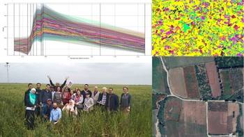
Eleven crop maps using remote sensing were produced in seven project countries in the context of a long training of trainers in 2019. Follow up actions in early 2020 for most of the countries included further data treatment and the need for new campaigns of field validation to improve the accuracy of the maps. Another area of ongoing work is the use of existing open source databases such as FAO WaPOR database to prepare ETc and water productivity maps.
Capacity development
- FAO in collaboration with IHE Delft Institute for Water Education (IHE Delft) and Eleaf organized a regional training for trainers on crop mapping using remote sensing. Sixteen people from seven countries participated in the training, and two participants from Tunisia participated as assistant master trainers. The training was organized in five blocks in three classroom sessions in Tunisia, Morocco and Jordan, and in between distance coaching of country teams with fieldwork.
- A regional training for trainers on the use of WaPOR database for ET and water productivity mapping was organized by FAO WaPOR project in Jordan. The same 18 people from the seven countries participated in the training.
- Training on the use of remote sensing for crop mapping and assessing vulnerability was organized by FAO with contribution from the World Food Programme, during the Land and Water Days, where 50 participants attended the training.
Resources
Training modules of the regional training on crop mapping using remote sensing have been prepared in English and French by IHE-Delft Institute for Water Education (IHE-Delft) and EleaF for FAO.