Near Real-Time Monitoring: A crucial tool to tackle deforestation

Near real-time monitoring (NRTM) of deforestation is proving to be invaluable in the ongoing fight against deforestation and the preservation of global forests. NRTM systems leverage various technologies and data sources to detect disturbances quickly and accurately in forests. They use data from satellites, drones, and ground sensors to detect changes in forest cover, such as illegal logging, clear-cutting, or fires as soon as they occur. Early detection is crucial for preventing further damage and taking swift action. By providing authorities with timely and accurate information, these systems enable law enforcement agencies to respond promptly to illegal activities in forests.
Reduced Emissions from Deforestation and Degradation (REDD+) is a framework aimed at reducing greenhouse gas emissions by curbing deforestation and forest degradation part of the Paris Agreement. The “+” stands for additional forest-related activities that protect the climate, namely sustainable management of forests and the conservation and enhancement of forest carbon stocks. NRTM plays an increasing crucial role in supporting these efforts by helping countries monitor and report changes in a timely manner.
Within the UN-REDD programme, the Food and Agriculture Organization of the United Nations (FAO) collaborates with various stakeholders and institutions in the Lower Mekong Region (LMR) to enhance forest governance. One of the aims under the UN-REDD Sustainable Forest Trade in the Lower Mekong Region (SFT-LMR) Initiative is to enhance law enforcement through the timely monitoring of forest disturbances. To kickstart this process, initial gaps were identified through individual country consultation sessions. Notably, some countries such as Thailand, Vietnam, and Laos have an operational near real-time monitoring system, while others like Cambodia and Myanmar lack fully functional alert systems. Challenges identified during these workshops can be categorized as follows:
- Management: resource requirements (database storage, verification through screening, and/or field validation)
- Sustainability: long-term maintenance of the system
- Integration: with national and/or subnational systems if in place
- Capacity building: when systems come from external partners
- Technical limitations: lack access to high spatial resolution imagery and use of radar in cloudy areas. Deforestation and forest degradation main drivers (e.g., small-scale agriculture and selective illegal logging) require high frequency and high spatial resolution for detection and/or validation
- Accuracy: a tendency to overestimate change alerts due to seasonality effects on single-date image analysis.
The near real-time monitoring process within the System for Earth Observation Data Access, Processing, and Analysis for Land Monitoring (SEPAL) comprises two key components. The first component involves the generation of alerts using the “Change alert” application, while the second focuses on screening and verifying these alerts using high-resolution satellite imagery “Deforestation alert analysis” application. The "Change alert" application was specifically developed to address the gaps mentioned earlier in the article. It is an open-source tool that employs a time series change detection approach based on continuous change detection and classification (CCDC) methodology. To address the issue of overestimating alerts, certain rules have been implemented to automatically filter out false alarms, including those stemming from seasonality or poor-quality data. Moreover, the tool provides flexibility by allowing users to adjust parameters to local conditions. The applications for near real-time monitoring are not confined to the LMR countries but can be applied anywhere in the world. These applications are designed to be user-friendly and require minimal technical expertise.
Additionally, integration tests have been conducted to ensure that countries with existing monitoring systems can generate alerts using their current infrastructure and use SEPAL for the validation of these alerts with high-resolution imagery. Furthermore, the deforestation alert analysis application also grants users access to global alert products.
The NRTM component, and the SFT-LMR initiative at large, strived to boost and enhance capacities through a combination of webinars, virtual training sessions, especially during the COVID-19 pandemic, and in-person workshops at country and regional level. Working hand in hand with national experts to achieve common goals, UN-REDD FAO experts maintained bi-weekly troubleshooting sessions. The feedback received on the methodology and tool was highly positive, indicating practicality of the application in addressing existing gaps.
As an example, Cambodia implemented the tool in four provinces located along the border with Thailand. The alerts generated by the tool underwent an initial screening process using high-resolution Planet Norway's International Climate & Forests Initiative (NICFI) imagery. Subsequently, a field validation exercise was carried out. The results from this validation exercise matched largely with the screening results. Considering the positive outcomes and feedback received during the pilot phase of the project, Cambodia made the strategic decision to incorporate near real-time monitoring into their national action plan for the years 2024-2027. This move reflects the country's commitment to scaling up the use of these tools as part of their efforts to protect natural resources.
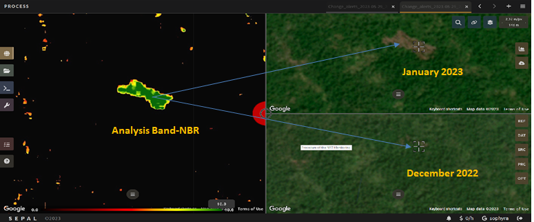
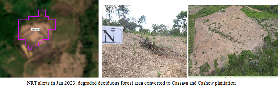
These images show an example of a near real time monitoring of deforestation with a multiview window to tweak the parameters. The window on the left shows an alert generated using the change alert application. Whereas the windows on the right are showing NICFI base maps from December 2022 and January 2023.
Photo credit: FAO/ Sophyra Sar
Author:
Naila Yasmin
Remote sensing and GIS Expert
FAO Forestry Division
Mathieu van Rijn
Forestry Officer, REDD+/NFM decentralized team
FAO Office for Asia and Pacific
Lorena Hojas Gascon
Remote Sensing and Land cover Assessment Expert
FAO
This story was originally published by the UN-REDD Programme