
Noticias
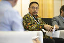
On 18 July 2018, institutional representatives gathered during the 6th World Forest Week in Rome, Italy at FAO Headquarters to attend an event entitled “Common Ground: multipurpose land-use planning for halting deforestation”. The event explored how participatory land use planning, can tackle the multi-sectoral drivers of deforestation and degradation. Panellists included government officials from Brazil, Indonesia, and Mexico, alongside representatives from United Nations Convention to Combat Desertification, UN Environment and the International Fund for Agricultural Development discussed how to scale up best practice for land-use planning.
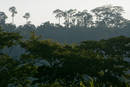
Land is a scarce resource increasingly affected by competition of mutually exclusive uses. Fertile land...
The Food and Agriculture Organization of the UN (FAO) and Norway’s International Climate and Forest Initiative (NICFI) have announced plans to scale up a digital FAO platform that assists countries in measuring, monitoring and reporting on forests and land use. The initiative is expected to contribute to the conservation and sustainable management of forests and increase accuracy and transparency in forest monitoring.
Read more from the International Institute for Sustainable Development's SDG Knowledge Hub.
Using free and open source software for forest monitoring and assessment, such as Open Foris, is critical to ensure the sustainability of Bangladesh Forest Department’s mandate to manage and conserve forests in Bangladesh.
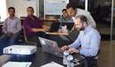
Development of a strong forest monitoring system with suitable baseline information archive is necessary for sustainable tree and forest resource management. An enriched baseline largely rely on robust inventory data collection with proper data management and analyzing process. Under Bangladesh Forest Inventory (BFI), a software application developed in FAO called 'Open Foris Collect' is being used to ensure efficient data collection and management. The Bangladesh Forest Department, with...
The Bangladesh Forest Department, with technical support from the Food and Agriculture Organization (FAO) of the United Nations, and in collaboration with universities, is finalizing the field data collection for the Bangladesh Forest Inventory. With the objective to re-locate the field inventory plots and monitor forest changes over time, the latest technological advances are used.
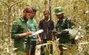
Effective monitoring depends wholly on the ability to re-locate the exact centre of the plots after several years between visits so that changes can be accurately recorded.
Several approaches are used to re-locate the plots, such as recording the geographic coordinates of the plot centre using...

El acceso a los datos satelitales y a las tecnologías geoespaciales más avanzadas se ampliará gracias a una colaboración más estrecha entre la FAO y Noruega, cuya Iniciativa Internacional sobre el Clima y los Bosques (NICFI, por sus siglas en inglés) acordó mejorar una innovadora plataforma digital de la FAO que ayuda a los países en la medición, seguimiento y presentación de informes sobre sus bosques y el uso de la tierra.