![]()
![]()
![]()
Reforesting marginal lands in northern China
An FAO agroforestry project in the Haut Atlas mountains
Stabilizing shifting cultivators in Thailand
New Hungarian forestry museum
Planning a paper industry in French Guiana
A multilingual dictionary on forest fires
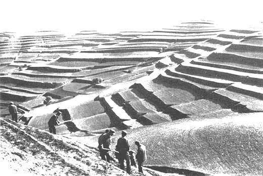
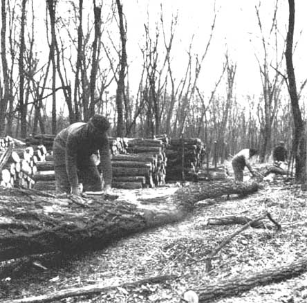
TREE PLANTING PREPARATIONS IN XIJI COUNTY where soil loss is 20 000 t/yr
Vast arid plateaux with deep gullies in a succession of broad terraces bordered by cliffs give the loess zones in northern China their characteristic appearance. Analyses of spores from these formations, the oldest of which date back 1.2 million years, have shown that they once carried woody vegetation which has now given way completely to a sparse grass cover.
In the heart of these loess plateaux, in Ningxia Huizu one of China's five autonomous regions, lies the Canton of Xiji. This canton, which covers an area of 314 000 ha, is particularly exposed to wind and water erosion precisely because of the presence of the loess. Soil loss may reach more than 20 000 tonnes a year. The Huang He (Yellow River), the middle reaches of which traverse this region, carries 1 600 tonnes of sediment through the Sanmen gorge every year, thus threatening riverine crops and peoples and clogging canals and reservoirs. One of the results of this heavy erosion is the leaching of millions of tonnes of phosphorus, nitrogen and potassium, which over centuries has led to growing impoverishment of the unstable and now fragile soils.
It is for these reasons that the Chinese Government, in its Three North Shelterbelt erosion control programme, has given priority to the twelve northern provinces. The World Food Programme (WFP), in turn, has invested through this programme US$23 million in food aid in the Canton of Xiji. The WFP project, scheduled to last five years (1982-87), covers 88 500 ha, or 28 percent of the canton's area, of which 55 000 ha are marginal but cultivatable land and 33 500 ha are degraded hills and infertile land. The use of this land for forest plantations, pasture and fodder crops will make it possible to reduce agricultural pressure and improve soil and water conservation.
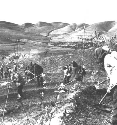
WFP food aid (55 tonnes of food) is intended partly to compensate households which have had to forgo part of their food production for the benefit of tree and shrub plantations, and partly to pay the 15 700 workers employed in developing and planting the bare hills and arid lands.
By 1985 40 000 ha of marginal land had been afforested. The 168 million young plants used by the project consist of more than 20 tree and shrub species, including pines, poplars and peach trees with a considerable production potential.
During the first four years of the project the targets for both the plantation of timber and fuelwood species and the production of fodder were more than met. According to the latest data collected, plantations of Cargana microphylla expanded from 800 to more than 8 000 ha, and those of Robinia pseudoacacia from 32 to 2 300 ha.
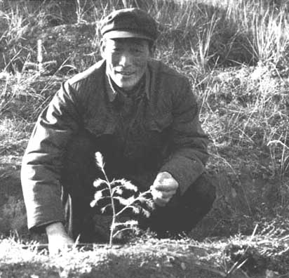
Training courses at different levels and in fields closely linked with the activities of the project have been given for the people. At the canton level, about 1 500 peasant technicians, one-third of them women, have been trained.
Finally, the project has created a considerable number of jobs because nearly all households have taken part in its implementation. In the longer term, employment and income could increase even more as the forests and grazing land now being established reach maturity.
PEOPLE'S COMMUNE LEADER WITH PINE tree planting needs local support
TREE PLANTING ON ERODED CONTOURS farmers receive food aid compensation
"When there is no longer enough space for us and our livestock, we have to clear the forest if we are to survive." These are the words of a stock-raiser in the central Haut Atlas mountains in Morocco, where the problem of agriculture and grazing becomes more acute every year, and where wood taken from the forest is almost double the normal amount.
The conflict between users and foresters is part of the tradition of these mountains. As long ago as 1917, an attempt was made to regulate grazing in the forest by decree, but the users never renounced the free exercise of their rights, and the "creamings" or appropriations are becoming more frequent every year. Hence the slow but irreversible degradation of the forests, with 56 percent of the land in the region now considered as unstable, eroded or likely to become so.
Reforestation also constitutes a threat to rural settlements because the space earmarked for forest plantations is usually agricultural land. Moreover, the forest represents for these populations a free source of income and consumer goods. How can these divergent positions be reconciled?
The Moroccan Government chose the province of Azilal, a central Haut Atlas zone and a good illustration of this situation, to be the subject of a management and development plan to meet the needs of an expanding population.
The province of Azilal covers one million ha, a vast part of which is formed by the calcareous High Atlas. Nearly 80 percent of the area is at altitudes above 1000 m, and 60 percent is above 1 500 m. The very rugged terrain consists of steeply sloping massifs and plateaux with precipitous edges. Depressions are drained by the main wadis: the El Abid, the Ahansal, the Lakhadar and the Tessaout. The climate is Mediterranean with oceanic influences and rainfall mainly in the autumn and winter. Although crop-growing is the principal activity, a considerable number of the 410 000 inhabitants practice animal husbandry; there are 850 000 head of small livestock and 45 000 head of large livestock.
The Government intends to base its development programme on seven points: equipment (means of communication, social infrastructures); populations (identification and territorial delimitation of user bodies, grouping of producers); land improvement (management, reforestation); extension of development works; increase in production capacity; marketing of products; diversification of activities.
Results expected include retaining the population in rural areas, increasing value added and incomes, and preserving existing resources.
In collaboration with FAO and UNDP, the Government intends, under the Azilal project, to prepare plans of action and open investment files with a view to the integrated rural development of the province.
The plan of operations covers two phases. The first consists of collecting, completing and summarizing data on the present situation and evaluating the area's potential; and also in identifying sectors where concrete improvements are possible. In the second phase, investment files will be prepared so that a project can be established to deal with priority work.
The project will undertake rangeland and forest management, and also to increase the extent of arable areas. This will represent a first step toward a solution of the agroforestry problems of the province, thereby creating living conditions that will induce the population to remain in its own region.
SHIFTING CULTIVATION AFTERMATH an attempt at stabilization
The Khorat plateau in the northeast of Thailand, with its poor and erodible soils and its limited rainfall, looks like a savannah where isolated specimens of dipterocarps predominate. It is ideally suited for livestock-raising, which is therefore concentrated in this area.
More than 36 percent of the population of Thailand lives in this region, the largest and poorest in the kingdom. Formerly, the northeast contained an area of natural forest covering 7 million ha, or about 42 percent of the total area. Illegal deforestation, which was giving cause for concern in the 1960s and 1970s, assumed alarming proportions in the 1980s. There are many reasons for the process of degradation: accelerated construction of arterial roads and large dams on the one hand and, on the other, the increasing demand for cash crops such as cassava, the removal of wood for fuel and for local building, and fellings by peasants in search of land. As regards the latter, it cannot be ignored that rural people see these forested areas, destined to become national forests or reserves, as precious agricultural land on which they are absolutely dependent for their survival.
These factors led the Government, through its Royal Forest Department, to earmark about 10 000 ha of the Khao Phoo Lang Forest Reserve for development in order to meet the long-term economic, social and ecological requirements of the area as harmoniously as possible.
At the request of the Government, FAO prepared a five-year project, due to end in 1986, costing US$1.1 million. This project has three components: agriculture, forestry and fisheries. Its immediate objectives are not only the restoration, protection and management of selected forest areas, but also the permanent settlement of shifting cultivators, diversification of agricultural production, strengthening of institutions and forestry extension work. In order to conserve the rural environment, the project intends to reduce forest degradation and to control erosion of agricultural and wooded land.
The project provides for the establishment, under the supervision of the Royal Forest Department, of more than 2 000 ha of forest plantations, and the protection of some 600 ha of natural forest. Ten agroforestry villages will be built to show how shifting cultivators can be grouped in communities and devote themselves to settled agricultural activities. Ten dams are also envisaged to supply the villages with water for domestic uses, for irrigating their vegetable gardens and for fish culture. Training will be provided in beekeeping, improved charcoal production from eucalypts (which the peasants are encouraged to plant themselves), aquaculture and animal husbandry.
One of the most significant results achieved by the project has been that the forest services have given the peasants the opportunity to develop good agricultural land. This measure is crucially important, since it dissipates the fears of the newly installed crop-growers that they might be evicted from their holdings after having put all their efforts and resources into working them. The award of usufruct certificates, later to become title deeds, will introduce the shifting cultivators to something quite new to them: the notion of stability and security as a result of owning their own land.
The distribution of nearly 200 000 fruit-tree seedlings and 200 kg of seed will enable the peasants to plant orchards in their own gardens or on the borders of their fields. This initiative has already shown interesting results in terms of community forestry: in 1985, 67 percent of the plants supplied went to farmers living outside the project area.
Field trips in other regions of Thailand and abroad will put both the peasants and the project staff in contact with new agricultural and rural development methods.
Through the creation of new forests, the restoration of natural wooded massifs and the building of agroforestry villages, the Government hopes to establish a sustained balance between conservation of the environment and equitable distribution of agricultural land among rural populations. The success obtained by the project to date, with the crop-growers now stabilized on the new land, has led the Thai authorities to request FAO, on the basis of experience acquired, to give greater emphasis to extension work.
A museum devoted to forests and wood, attached to the University of Sopron in Hungary, has recently been opened.
The idea of assembling all kinds of material relating to forestry dates back to 1924, when the first Hungarian forestry education establishment was set up. But for a long time circumstances prevented implementation of this project.
The museum now established and opened to the public contains a collection of topographical instruments dating back to the seventeenth century, forest management and measuring instruments, an ornithological collection, a wildlife collection of great historical value and more than 70 wood machines, including a framesaw shown at the international exhibition of 1900.
One of the museum's aims is to lay the basis for collaboration with other forest and wood museums throughout the world.
From Revue forestière française (6), 1985
Operation ECEREX (ecology, erosion, experimentation) was launched in French Guiana (South America) by research bodies under Unesco's MAB 1 programme. Its exact title was "Development of Guiana's forest ecosystem: - ecological study of its evolution under the effect of the transformations". Its purpose was to study and try to resolve the problems posed by the establishment of a large-scale paper industry in order to assist the Government in its efforts to accelerate the process of industrial development in the country.
At first the plants installed were to obtain their supplies from the natural forests. Later it was decided to supply the plants from stands of fast-growing species (pines and eucalypts).
The proposal was to study the natural environment and analyse the ecological impact of utilizing the forests to provide raw material for paper plants. For this purpose, ten watersheds, each with an area of 1.5 ha, were selected, and various types of management were conducted in an area characteristic of the local forest. A plot of primary forest was cleared so that regeneration after logging could be monitored. The studies have covered modification of hydrology and erosion after management, organic material, bioclimatology, botany, soil biology and leaching by ram.
This research work, which has now been in progress for almost ten years, will soon enable Guiana to install a paper industry capable of meeting the country's social and economic requirements without endangering its vast forest resources.
From Bois et forêts des tropiques, 1984
The refrain is repeated, year after year, that thousands of hectares of forest in Europe's Mediterranean regions have been destroyed by fire. But every year, too, kindling a faint ray of hope, new measures for preventing and fighting the fires are proposed. All over the Mediterranean region steps are being taken to make the forest less vulnerable and less combustible: clearing of undergrowth; diversification of species; establishment of fire-breaks; the launching of education and information campaigns; and more efforts at effective fire-fighting systems.
As a contribution to these efforts FAO has just completed a multilingual glossary on forest fires.
The project was launched in 1977 at an FAO/Unesco technical consultation on Mediterranean forest fires. Three specialists, one French, one Spanish and one American were summoned. After having exchanged existing terminology, they established a trilingual version for each of the three languages. Subsequently, German and Italian specialists in forest fires offered to help in completing the project. The result is the Wildland Fire Management Terminology, now being printed, which represents the English contribution and is based on the most current or most recent terms used in the United States and Canada.
The glossary contains about 1 500 terms, each with a definition in English and the equivalent term in French, German, Italian and Spanish. To make it more useful for Spanish-speaking countries, the term used in Spain is followed by that used in Latin America. A definition in English accompanies each term.
The purpose of this glossary is to present and define the terms most frequently used in discussions and works on the control of forest fires which do not appear in current dictionaries. It also contains terms used in related fields: meteorology, aviation and structural protection against fire.
The French and Spanish versions of this glossary are now under study and form the subject of a project proposal submitted for UNDP approval. The work will be published in the FAO Forestry Paper series. It is easy to consult, accessible to everyone and constitutes a valuable tool for international cooperation in the struggle to prevent and combat forest fires.
HUNGARIAN FOREST WORKERS a new museum for forestry
![]()
![]()
![]()