![]()
![]()
![]()
Within the context of coastal fish resources in Asia, the increasing importance of seafarming to aquaculture production has been well documented. Its status, future potential and constraints in terms of production and employment have also been identified. Refer to the bibliography for a selection of relevant publications. The Directory of Institutions and Scientists in the ASEAN Region Involved in Research and/or Management Related to Coastal Areas by Chua et. al., published in 1989, is a recommended reference source and should be used to supplement the information contained in this report.
The importance of mapping, Geographical Information Systems (GIS) and remote sensing (satellite imagery and aerial photography) to aquaculture resource management also is well documented.
According to Kapetsky (1987), one of the fundamental problems in planning for the expansion of aquaculture is to accurately assess the land, water, economic and human resources available for development. Comprehensive planning for aquaculture development is still uncommon. One of the reasons that such planning is not routine is that the means to synoptically integrate and analyze diverse kinds of resource, environmental and economic data have been lacking. Therefore, there is a need for an approach which can be used to rapidly identify areas of a country, or of smaller administrative or ecological units, suitable for various kinds of aquaculture as an aid to development planning. The means to facilitate such evaluations are available: specialized computer software which enables storage, manipulation and analysis of large quantities of data of diverse kinds (including those acquired by remote sensing techniques) having a common locational or geographic base. With such automation, reporting can be in the form of tabular data, graphics and, most importantly, geographically coordinated maps. These are called Geographical Information Systems (GIS).
Other aspects which we consider of paramount importance to this project are as follows:
The fundamental importance of traditional mapping should not be undervalued because of pressures to introduce high technology “solutions” such as GIS and remote sensing. These recent technologies are in fact only aids to resource management. Mapping produced by manual methods can be a valuable management tool; it can be digitized at a later date if automation is subsequently introduced (Appendices II and III).
Based on Canada's experience in coastal resource management using traditional mapping, GIS and remote sensing, a clear distinction must be made between the level of expertise required to become “power users” of these technologies and that required by the resource managers to communicate effectively with the specialists and to appreciate the benefits and constraints of these technologies. Members of the interdepartmental committee previously referred to should be encouraged to attend GIS and remote sensing familiarization workshops. However, a GIS expert must be identified within the department of fisheries. This may involve the hiring of a specialist or the training of a fisheries personnel with a background in computer sciences.
The preparation of the Regional Seafarming Resources Atlas and subsequent phases should be executed within the wider context of coastal zone management. Seafarming per se should also be mapped as an integral component of coastal aquaculture.
The Regional Seafarming Resources Atlas should be considered as the first phase of a sequential process to develop national coastal resource management atlases and information systems. The Regional Atlas will consist of the world, Asian and country perspectives. The latter will include national small-scale maps portraying the distribution of the major seafarming groups (e.g., molluscs, finfish, etc.) and each of these groups will then be subdivided into their component “families” and portrayed at the same scale (refer to Figure 1). The production of the Regional Seafarming Resources Atlas can be undertaken by NACA staff with minimal professional assistance. The Regional Atlas should be used to sensitize readers to the importance of seafarming to the region as a component of aquaculture; as a labour intensive industry and employment alternative; and as a major source of protein for national and export requirements. The Regional Atlas will be a prerequisite for the submission of a regional proposal to develop national atlases.
All phases of the national Seafarming Resources Atlas project should be under the control of a national interdepartmental committee chaired by a representative of the Department of Fisheries, with NACA acting as the coordinating body through the respective national coordinators. This recommendation is based on experience with land use planning in Atlantic Canada which is predominantly coastal zone (Appendix IV).
The national atlases at a provincial scale can be developed further to the site specific level and automation can be introduced as funds and expertise permit. The National Atlas will consist of an Asian and country perspective as in the Regional Atlas and, in addition, large-scale provincial maps indicating the major groups and their constituent species (refer to Figure 2). Other relevant parameters can be added as data and funds become available. The National Atlas should be the responsibility of the national interdepartmental committee, coordinated by the NACA country reresentative. Funds required for the production of the National Atlas should consist of both national funds (when possible) and international funds secured with the aid of the Regional Atlas.
REGIONAL SEAFARMING RESOURCES ATLAS
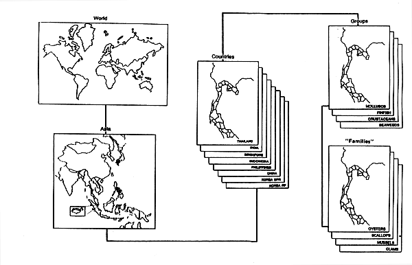
Fig 1
Reports
Report of the First National Coordinators' Meeting of the Regional Seafarming Development and Demonstration Project, 27-30 October 1987, Bangkok, Thailand. 71.
Report of the Second National Coordinators' Meeting of the Regional Seafarming Development and Demonstration Project, 20-23 September 1988, Singapore. 102 pp.
Report of the Third National Coordinators' Meeting of the Regional Seafarming Development and Demonstration Project, 24-27 August 1989, Qingdao, China. 103 pp.
Report of the FAO Asian Regional Workshop on Geographical Information Systems: Applications in Aquaculture, 5–23 December 1988, Bangkok, Thailand. FAO Fisheries Report No. 414, FIRI/R414 13 pp.
Report of the Seafarming Resources Atlas Mission. Regional Seafarming Project RAS/86/024, July 1989. 74 pp. (att'd Atlas has 83pp. & is 1990)
NATIONAL SEAFARMING RESOURCES ATLAS
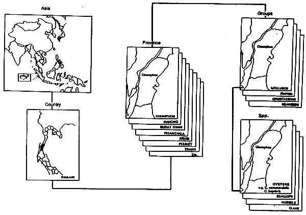
Fig 2
![]()
![]()
![]()