![]()
![]()
![]()
The general layout as shown in Fig. 10 is a modular grouping of 11 family size units of nursery and rearing ponds in a parallel-series module, interconnected by supply and drainage channels to individual water inlet (and outlet) control gates. The main control gate is located at the head of the upstream ponds. This structure provides the control of water inflow and outflow.
To supply water to the pond subgroup, water is diverted to the secondary canal that feeds the subgroup. Individual nursery and rearing ponds get their water supply through wooden tertiary gates.
Flooding of all the ponds to the desired depth by tidal flow is attained after three successive high spring tides.
A typical family size unit consists of a nursery pond of 0.2 acre (0.08 ha) and two rearing ponds of 1.4 acres (0.56 ha) each (Fig. 11). To include the spaces taken up by the dikes, their side slopes and water canals, the average gross area for one unit of family pond is in the order of 4.0 acres (1.6 ha).
Ponds are laid out in such a manner that their longer axes are parallel to the prevailing winds (NE and SW monsoons). This arrangement provides aeration of the pond water and a lesser exposure of the dike side slopes to surface waves due to winds.
Two channel bypasses are provided, one for supply (for supplying the ponds with water) and one for drainage (for the evacuation of the excess water and for emptying the ponds). Both may, however, be used for flooding and drainage.
A pump is integrated into the design of the main gate to supplement water during times of high water neap tides, when by tidal flow, the ponds cannot be flooded to the required depth.
Water exchange may be done during times of low waters. Water is pumped through the main gate into the supply canal and is let into the tertiary inlet gates of the individual ponds. Bottom pond water is allowed to drain out of the ponds through tertiary outlet gates into the drainage canals and into the downstream drainage canal gates. A constant head is maintained in the supply canal1.
For the pilot module, there is one main concrete gate (MG), two secondary concrete gates (SG1 and SG2) located at the headponds at the two supply canals, two secondary concrete gates (SG3 and SG4) located at the downstream ends of the drainage channels.
Individual pond water inlets are the tertiary wooden gates (TG2 and TG1) located at the supply canal dikes at near the corner or at the middle of the short side of the nursery/rearing pond, and individual pond water outlets are the tertiary wooden gates (TG2 and TG1) located at the drainage canal dikes near the corner or at the middle of the short side of the nursery/rearing pond and diagonally opposite the tertiary supply gate (Fig. 10).
A buffer zone of not less than 20 m (65.60 feet) from the river bank is left undisturbed for protection against erosion. Mangrove is not cleared from this zone and if no vegetation is growing, some should be planted.
A two-stage progression is chosen as the shrimps are to be grown to medium size. Transfer of juveniles from the nursery to the growing ponds is facilitated by having the NP and RP adjacent and the pond bottom elevation decreases from NP to RP, to aid in the transfer of shrimp juveniles by water flow.
The relative size of the pond units is such that for the two stage progression, the ratio of rearing to nursery ponds is 7:1 by area. A scheme of management is given in Annex E and a time schedule in Annex F.
The shrimp pond has its own specific design. It consists of a peripheral canal and a flat area in the central part of the pond. The deeper water in the peripheral ditch is used as a refuge for the shrimp from high water temperature on a hot day. It also serves as a holding area when the water level is reduced for the extermination of predators. The shallow portion in the middle of the pond promotes the growth of algal food.
Fig. 11 shows a typical layout designed for intensive practice. The pond module consists of a 800 m2 (0.2 acre) of nursery pond and two rearing ponds of 5 600 m2 (1.4 acre) each. The module could serve for finfish culture as well.
The nursery pond is placed adjacent to and between the two rearing ponds in the module. This is to reduce the stress to the animal that may arise during transfer. The size of the nursery pond is determined (or is in a ratio to the rearing pond) by the number and size of juvenile shrimps required to fill the production capacity of the rearing pond. Nursery and rearing pond dimensions and cross-sections are shown in Figs. 11, 12 and 13.
The following basic criteria and design procedures are considered in the design of the perimeter (main) dike.
Alignment and location - the main dike more or less runs parallel to Sungai Gelam (Gelam river), completely surrounding the entire area of the pilot development. Tentative locations of the dike centre lines are indicated in Fig. 10, plan of the proposed layout. The centre lines of the perimeter dike are located at a distance of not less than 20 m (65.60 feet) from the Sungai Gelam bank, leaving a strip of undisturbed buffer of mangrove.
Dike alignment is as straight as possible. At stretches where the alignment changes in direction, a curve is provided and hence scouring at the side slopes is minimized.
Top width - the top width of the main dike is 2.0 m (6.56 feet) except at short portions where the dike may cross a stream or an old channel in which the minimum top width of not less than 2.5 m (8.2 feet) is used. No portion of the main dike is to be used as a vehicular roadway.
Side slopes - Fig. 14 shows the cross-section of the main dike. Pond-side slope is at 1:1 (horizontal to vertical) while the river-side slope is at 1.5:1. At portions where a dike crosses an old channel or a stream (not indicated on the map), the same side slopes are maintained but the width of the top is increased toward the river side. A “banquette” is provided at these portions, the top of the extended base (berm) being about 0.30 m above the normal ground. The width of the berm will depend on the depth of the old channel. For organic soil, the minimum berm width is adopted as 3.0 m (0.915 feet).
Cut-off trench - the cut-off trench should be of sufficient depth and width to minimize the hazards of seepage and piping.
Elevation of the top of the dike - the height of the dike at the main gate is calculated as follows (Fig. 14):

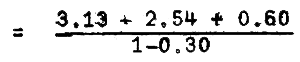
= 1.70 m (5.58 feet)
| Where: | Hmd | = | elevation of dike above the ground |
| HAT | = | 3.13 m, assumed for highest astronomical tide, also highest high water spring (2.90 m) corrected for tidal range ratio, thus 2.90 × 1.08 = 3.13 m (Table 3) | |
| GE | = | 1.42 + 1.12 = 2.54 m is ground elevation at site of main gate, 3.7 feet (1.12 m) above LSD which is 1.42 m above chart datum | |
| Hfb | = | 0.60 m (1.97 feet), height of freeboard | |
| %S | = | percentage allowance for shrinkage 0.30 m but could be more for soil of high organic content and poor construction methods. |
The value of 1.70 m (5.58 feet) is the design height after compaction (Figs. 14 and 15). Lim (1969) and Kato (1975) in test analyses made, limit the value of height to about 2.0 m (6.56 feet) for types of soil found in mangrove swamps. The elevation of the top of the perimeter dike above chart datum is therefore, H = 1.70 + 2.54 = 4.24 m (13.90 feet)
At high water stages, the Gelam river catchment outside the bund is inundated. The construction of the perimeter dike will restrict or reduce this catchment area and may result to higher tide levels. It is believed though that the freeboard allowance of 0.60 m is adequate against overtopping.
Permeability tests on soil at the site were not conducted and effective dike width required for design against seepage has not been determined.
Before construction, soil borings may be done at the dike path to determine the depth of the organic top layer. As the main dike will be constructed on such soil, it is never constructed in one lift and the contractor should be advised of the need for, and agree to, a construction period during which the dike should be constructed in at least three stages, each stage approximately one-third of the designed dike height, Hmd. Refer to Section 6, construction of fishpond, for further discussions on dike construction.
The dike should be inspected regularly and especially after heavy rains. Any weak spots should be repaired immediately. Trees should not be allowed to grow on the dike. Sod cover growth may be promoted. Trapping or killing of burrowing crustaceans should be done periodically (see also Section 4)
Height maintenance is to be done periodically as subsidence and settlement occur after a period of years.
Undermining or scouring of the foundation of perimeter dikes by high velocity river currents is to be expected as the dike is constructed of erodible material. The methods commonly used to provide protection against undermining are the following:
Anchoring a heavy, flexible mattress to the bottom of the perimeter dike. Revetment made from whole trees tied together and anchored by “deadmen”1 buried in the dike is the cheapest form of dike protection against scour. The trees are laid along the bank with the butts upstream with enough overlap and the trunks are anchored by cables to the “deadmen” set in the dike. Piling may be used sometimes instead of “deadmen”2
Vegetation plays an important part in the control of bank erosion. A buffer zone of not less than 20 m wide is left undisturbed.
Sediment bars, stumps, debris and drifts which may disturb the smoothness of the river flow should be removed from the stream channel.
Dike side slope at the river side should not be steeper than 1.5:1. At curved sections of the stream, the toe of the perimeter dike can be stabilized by driving timber piling to form a continuous protection of the toe. Spur dikes and jetties can influence the flow of the stream and should not be used.
Continued maintenance of bank protection works is essential to avoid possible damage during stream flood flows.
2 Department of Agriculture, “Field Manual, Soil Conservation Service”, U.S.A.
Two secondary dikes run parallel and form the supply and drainage canal cross-sections. These are indicated on the general layout plan (Fig. 10).
Top width - the top width is 1.50 m (4.92 feet)
Side slopes - the side slopes are maintained at 1:1
Freeboard - the freeboard allowance is 0.30 m (0.98 feet) above the predicted highest high water of 3.13 m1
A cut-off trench of 0.5 m wide and depth down to canal bed elevation shall be provided.
Top elevation - the dike top slopes down in elevation at a gradual rate from where it intersects the main dike. The elevation of the top of the secondary dike is obtained as follows (Fig. 16).
Assuming average ground elevation at the pilot development to be 2.38 m,
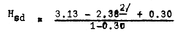
= 1.50 m (4.92 feet)
Elevation above chart datum is,
Hsd = 1.50 + 2.38 = 3.88 m (12.72 feet)
2 Average of spot levels indicated in Fig. 7
Tertiary dikes partition the nursery and rearing ponds. These are indicated as TD in Fig. 10, general layout plan of proposed pilot development.
Top width - the top width of the secondary dike is 1.00 m
Side slopes - side slopes are maintained at 1:1
A cut-off trench of 0.5 m wide and depth down to canal bed elevation shall be provided.
Elevation of the top of tertiary dike - the elevation of the top of the tertiary dike is obtained as follows (Fig. 17).
= 3.35 m above chart datum
Assuming average ground elevation at the pilot development to be 2.38 m, the height of the tertiary dike above original ground would be
Hg = 3.35 - 2.38
= 0.97 m (3.18 feet)
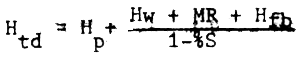
A freeboard of 0.50 m is to be used so that when excess water in the amount of one-third of the pond water volume is taken into the pond during water exchange, dike overtopping is prevented. This excess is drained out of the pond during the succeeding low tides.
The height Htd is therefore:
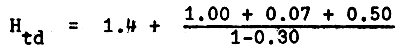
= 3.64 m
The height above ground level, Hg is,
Hg = 3.64 - 2.38
= 1.26 m (4.13 feet)
The width of the sluice way of the main control gate is calculated for maximum utilization of tidal energy, by using the predicted mean high water spring tidal fluctuation for 1979 (Fig. 18). This gives a conservative design. The design considers the following requirements:
To be able to flood all the ponds (at the same time) in three to four successive mean high water spring tides to the desired pond water depth of 1.00 m (average), allowing 20 percent water loss. Under this condition, the complete drainage of the ponds would require a lesser period of time during the low water flows.
To be able to drain the ponds in a less period of time during pond preparation and during periods of heavy rainfall (alternate function of drainage and flooding).
To be able to tide over future water supply requirements for adjacent and succeeding phases of pond development. Flooding of the ponds of these phases would therefore be in more than three successive tides, but possibly not more than six (in 3 days).
The main gate is located at the perimeter dike upstream of the ponds as indicated on the general pond layout (Fig. 10). This structure is an open-type construction of reinforced concrete. Slots and grooves for screens and wooden flashboards are provided at both ends of the gate. The sluiceways are to be of the same width, as they are for the secondary gates. This allows the boards and the screens to be interchangeable. The open-type construction provides easy work access to cleaning and the removal of barnacles within the sluiceway.
Fig. 19 shows the bottom elevation of the main gate in relation to the various tidal levels, pond and canal bottom elevations. Stagnant water to a depth of one-third height of all the flashboards is maintained at the gate floor. This provides the required water cushion for pump and tidal outflow.
The lowest high water is at elevation 1.50m (4.92 feet) which occurs in some days of some months of the year. During these periods, pumping will be resorted to should flooding the ponds be necessary for required pond depth and water exchange. This is so, as pond bottom elevation is taken at 1.4 m.
The width of each sluiceway is limited to a maximum of 1.20 m (3.93 feet) for ease in the manual operation of the wooden slabs and screen frames. The design includes the pump water intake structure and sump. The determination of the width of the sluiceway made use of the procedure outlined in Kato (1975) “Guide to design and construction of coastal aquaculture pond”. Representative design tide curve with mean high water spring for 21 February 1979 (Table 4) is used in the preparation of Fig. 18 which complements such procedure. Annex D gives the design computations for width of the sluiceway.
The methods and specifications for concrete and concreting shall be followed in the construction of the main gate (Annex G).
Water exchange is effected by tidal water supply that is allowed to flow into the ponds during high tides, an amount equal to about one-third of the pond water volume. During high tides excess water may be let into the ponds and this excess is drained through the outlet gate during the succeeding low tide.
During high water neaps, the depth of water in the ponds attainable by tidal energy is only 0.5 m (1.69 feet). Flooding the ponds to the required depth of 1.00 m during this period will require the use of pumps.
The secondary gates, SG1, SG2, SG3 and SG4 are open-type, reinforced concrete, two-door design at the upstream ponds and one-door design at downstream of the drainage channels. These are indicated as SG1 and SG2 (supply gates) and SG3 and SG4 (drainage gates) in the general pond layout (Fig. 10).
A pair of grooves is provided at both ends of each sluiceway for screen frames and two pairs of grooves are similarly provided at the centre for wooden flashboards or slabs to control the inflow/outflow of water.
With both gates SG1 and SG2 fully opened,all of the ponds in the module can be flooded in three successive spring high tides. With one of these gates closed and the other open, half of the number of ponds in the parallel-series branch can be flooded in half the time. The width of the sluiceway is maintained at 1.00 m (3.28 feet). This gives a standard and uniform flashboard length for all gates. Details of the secondary gates, SG1 and SG2 are shown in Fig. 20 and specifications for concrete and concreting works for these gates are discussed in Annex G.
Gates SG3 and SG4 are of similar design as SG1 and SG2 except that these gates are of the one-door affair. The gates are designed to drain water exchange and for handling seepage water from some ponds through the drainage channel. Details of these secondary gates are shown in Fig. 21 and specifications for concrete and concreting works for these gates are discussed in Annex G.
The tertiary gates for the individual rearing ponds are indicated as TG1 and for the individual nursery ponds as TG2 (Fig. 22). Gates TG1 are wooden boxed frames assembled from 1" × 10" (0.025 × 0.254 m) preservative-treated planks and 2" × 4" (0.05 × 0.10 m) studs. Gates TG2 are also wooden boxed frames of similar design as TG1 except for a change in the dimensions of the sluiceway. It is a boxed frame of preservative treated 1" × 10" (0.025 × 0.25 m) preservative-treated planks and 2" × 3" (0.05 × 0.07 m) studs. Fig. 22 shows a typical tertiary gate. Gates TG1 and TG2 are located as shown on the general pond layout (Fig. 10). The tertiary gates are designed to cater for a daily change of one-third of the total volume of pond water during spring tides.
The supply canal distributes the water intake from the main gate to the individual ponds. From the main gate, the canal bed slopes upward into the last pond, the slope being such that silting velocity of water is maintained when the main gate is opened during tide inflow; the canal water flows the downward slope with a transport velocity that carries the sediment out of the main gate without causing erosion of the canal bed.
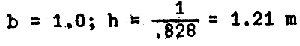
The cross-section of the supply canal is trapezoidal, with bank side slopes of 1:1. The ratio of the width of the bed (b) to the depth of water (h) is such as to have a cross-section of maximum hydraulic efficiency and minimum seepage. This relationship is expressed, for side slopes of 1:1, as
b = 0.828h1
If the depth of the canal water h is taken as 1.3 m2 at maximum discharge, this gives a tentative value of:
b = 0.828 × 1.3 = 1.07 m (use b = 1.1)
A = bh + h2 = 1.1 × 1.3 + 1.32
=3.12 m2 (cross-section area of canal)
Transport velocity allowable without erosion of the canal bed and sides for alluvial silts with colloidal particles is 1.52 m/sec. (Fortier and Sobey, 1926, Permissible Canal Velocities, Transactions of ASCE 89:955).
Q = Av = 3.12 × 1.52 = 4.74 m3/sec.
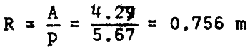
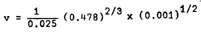
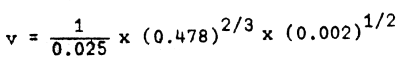
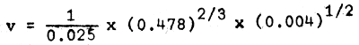
No consideration, however, was given to the slope of the channel bed and its effects on velocity of flow. This constraint is considered by using Manning's formula3:
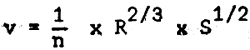
with “n” = 0.025 (for alluvial soils)
P = b + 2a = 1.10 + 2 (1.414 × 1.3) = 4.77 m4
2 Roughly, after subtracting pond bottom elevation of 1.4 m from designed high water level of 2.7 m.
Using bed slope, S = 0.002
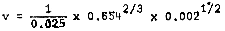
= 1.41 m/sec.
Q = Av = 3.12 x 1.41
= 4.39 m3/sec.
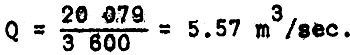
The maximum discharge through the main gate by tidal flow is 20 079 m3 in one hour (T13 - T14)1. This gives a discharge,
The width of the bed is increased to 2.0 m without changing the bed slope.
A = bh + h2 = 2.0 × 1.3 + 1.32 = 4.29 m2
P = b + 2a = 2.0 + 2 (1.414 × 1.3) = 5.67 m
= 1.56 m/sec.
Q = Av = 4.29 × 1.56
= 6.69 ≈ 5.57
Canal dimensions (Fig. 23) are as follows:
B = 2.0 m
h = 1.30 m
side slope = 1:1
bed slope = 0.002 (0.20 m rise in 100 m run)
The drainage canal is designed to handle one-third of the total pond water drained during water exchange within one full low tide cycle of 4–5 hours. Total pond water at full depth = 179 053 m3 and one-third of the amount is 59 684 m3.

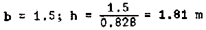
For maximum hydraulic efficiency, b = 0.828h for a 1:1 side slope
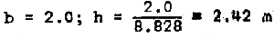
(2) If half of the ponds are to be drained completely in two days during four consecutive low tides,
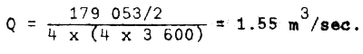
(3) If all of the ponds are drained at the same time,
Q = 1.55 x 2 = 3.10 m3/sec.
The drainage canal shall be designed for a discharge, Q of 4.14 m3/sec.
n = 0.025
v = 1.52 m/sec. (max.)
S = 0.001
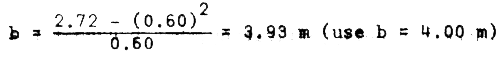
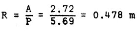
The drainage canal shall have a big b to h ratio. The depth of water h, in the canal should be such that a head is maintained between the pond and canal water. Pond water goes out to the canal through the flash-boards positioned to drain out the bottom layer of the pond water. This would not give an efficient canal cross-section for the required discharge, but this requirement shall be waived:
Q = Av
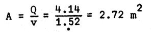
A = bh + h2
2.72 = b (0.30) + (0.30)2
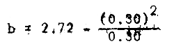
= 8.76 m (too wide)
use h = 0.60
P = 4.0 + 2 (1.414 × 0.60)
= 5.69 m
= 0.772 m/sec.
Increase the bed slope, S = 0.005
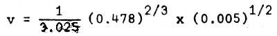
= 1.728 m/sec. > 1.52 (revise)
Decrease the bed slope, S = 0.002
= 1.09 m/sec. < 1.52
Increase S = 0.004
= 1.54 m/sec. ~ 1.52 m/sec (OK)
Q = Av
= 2.72 × 1.54 = 4.18 m3/sec. ~ 4.14 m3/sec (OK)
Use the following drainage canal dimensions (Fig. 24)
b = 4.00 m
h = 0.60 m
Side slope = 1:1
S = 0.004
The centre buildings are located in the reclaimed area outside the bund indicated in Fig. 10 of the general plan layout.
The office and laboratory are housed in the same roof. The structure is a single storey building of mixed masonry and timber construction. For the initial phase, the floor area of the office and laboratory is approximately 300 m2.
Staff quarters are single storey buildings of mixed masonry and timber construction having the following floor areas:
| Class D quarters | - approximately 120 m2 (1 unit) |
| Class F quarters | - approximately 80 m2 (3 units) |
Other buildings to be constructed are:
| Storehouse/bodega | - approximately 70 m2 (1 unit) |
| Guardhouse | - approximately 12 m2 (1 unit) |
| Garage | - approximately 50 m2 (1 unit) |
- the site can be reached by constructing a 2-km paved road from the Kampong (village) to the bund. From this point to the project site the bund is used as a roadway.
- a timber bridge designed for vehicular traffic shall be constructed to span the burrow pit (drainage canal). The existing timber bridge may be propped for use.
- there is no information on the possibility of obtaining ground water at the site. The freshwater in the canal (burrow pit) shall be analyzed for chemical pesticides, etc. and when found suitable can supply the freshwater needs of the centre.
- electricity could be obtained from the main lines of the village by the installation of about 2 km of transmission lines to the site.
- two pumps of low head and high volume of discharge in parallel operation shall be installed at the main gate. These pumps should be coupled to a diesel-engine.
![]()
![]()
![]()
 in Manning's formula.