![]()
![]()
![]()
A large number of areas appearing to contain suitable sites for pond construction has been pre-selected through the first-stage screening procedure as explained in the previous section. These pre-selected areas will have to be physically inspected to locate the best site for ponds within each area. This section provides guidelines for field site evaluation activities to do this. Descriptions of the actual tests and procedures are not included because these are well-documented in the literature.
Field site evaluation requires a workplan which lists the parameters to be verified. This is best arranged in the form of a checklist as suggested in Table 5.1. For the purpose of field site evaluation for ponds in mangroves the site-screening parameters have been grouped in four specific categories. These are:
| Checklist | Rating* | |||||||||||
|---|---|---|---|---|---|---|---|---|---|---|---|---|
| Site Location | Present State | Future Development | Suitability | |||||||||
| Category 1: Engineering | O | M | A | G | O | M | A | G | O | M | A | G |
| 1.1 Water supply | ||||||||||||
a) Availability of stream for intake channel | ||||||||||||
b) Stream morphology | ||||||||||||
| 1.2 Hydrology | ||||||||||||
a) River discharge | ||||||||||||
b) Flood stage | ||||||||||||
c) Turbidity (visual) | ||||||||||||
| 1.3 Topography | ||||||||||||
a) Land area for prototype of pond layout | ||||||||||||
b) Ground elevation | ||||||||||||
| 1.4 Soil | ||||||||||||
a) Soil characteristics (visual) | ||||||||||||
b) Soil sample — Lab. analysis | ||||||||||||
(i) Composition | ||||||||||||
(ii) Acidity | ||||||||||||
(iii) Potential acidity | ||||||||||||
(iv) Pesticides residue | ||||||||||||
| Category 2: Water Quality | O | M | A | G | O | M | A | G | O | M | A | G |
| 2.1 On-site water analyses | ||||||||||||
a) Salinity | ||||||||||||
b) Salinity profile | ||||||||||||
c) Temperature | ||||||||||||
d) Dissolved oxygen (DO) | ||||||||||||
e) pH | ||||||||||||
| 2.2 Water sample analyses | ||||||||||||
a) Biological oxygen demand (BOD) | ||||||||||||
b) Sediment load | ||||||||||||
c) Sediment-settling rate | ||||||||||||
d) Bacteriological test (E. coli count) | ||||||||||||
| 2.3 Water pollution risks | ||||||||||||
a) From agriculture | ||||||||||||
b) From industries | ||||||||||||
c) From ship traffic | ||||||||||||
d) From settlements | ||||||||||||
| Category 3: Forestry | O | M | A | G | O | M | A | G | O | M | A | G |
| 3.1 Forest economy | ||||||||||||
a) Species composition (in regard to forest interest) | ||||||||||||
b) Growth condition (standing biomass) | ||||||||||||
c) Management scheme | ||||||||||||
d) Value of site | ||||||||||||
(i) timber | ||||||||||||
(ii) other products | ||||||||||||
| 3.2 Ecology | ||||||||||||
a) Site in regard to marine habitat | ||||||||||||
b) Width of protective belt (or possibility for sufficient belt) | ||||||||||||
| Category 4: Socio-Economics | O | M | A | G | O | M | A | G | O | M | A | G |
| 4.1 Infrastructure | ||||||||||||
a) Services provided by government | ||||||||||||
b) Private sector services | ||||||||||||
| 4.2 Verification of input-output | ||||||||||||
a) Ex-farm prices | ||||||||||||
b) Pond operation costs | ||||||||||||
c) Seed, feed availability | ||||||||||||
| 4.3 Welfare and general development aspects | ||||||||||||
a) Increase in number of fish farmers — shift from catch fishery | ||||||||||||
* Rating Categories:
O = not suitable
M = marginal, can be accepted if other parameters rate good
A = acceptable, i.e., average
G = good
The site verification procedure under each of these categories is illustrated in Fig. 5.1. Within each category a hierarchical sequence of investigations is undertaken. This is because some parameters, those which appear first in the flow chart sequence, must be found to be suitable. Otherwise, if unacceptable, these will lead to immediate rejection of the site. For example, as shown under the engineering category (1) in Fig. 5.1, a site for pond construction would not be suitable unless there is an appropriate stream for water supply nearby. In contrast, the acceptability of other parameters may only be measured in degree. The relative significance of these parameters may only be measured in degree. The relative significance of these parameters can be compensate each other to a certain extent, or be weighed comparatively between sites. For example, under the socio-economic evaluation category (4) (Fig. 5.1), both availability and costs are used as rating factors. The idea here is that fish feed, for example, can be made available anywhere if one is willing to pay enough for it. Thus, for a site which rates as acceptable or good on all other parameters, paying a high cost to make fish feed available would not eliminate the site from being rated suitable overall.
An important general aspect of the site evaluation process is the variation of parameters with time. For example, the salinity at a proposed water intake in the mouth of an estuary may vary daily according to tidal state as well as seasonally with rainfall. Some water quality parameters may also vary in the same way, but also may experience a long-term change due to shifting land-use patterns in the watershed (e.g., new housing or industrial-estate development, mine openings, or expansion of agriculture).
In category (3), forestry (Fig. 5.1), absolute judgments on the suitability of a site may be difficult. While most of Malaysia's mangrove forests are forest reserves, only some mangrove areas in Malaysia are under well-developed and well-executed management plans. Other resources are not managed, or are only little managed. This means that for some areas, the economic value is well-known, for others not. One would tend not to choose for aquaculture mangrove forest areas which are well-managed and of high commercial value, if there are equally suitable areas for aquaculture elsewhere in a forest of less value.
The field survey should be done by the same kind of survey team for the first-stage screening. It is important for the efficiency of the survey that the members of the team have considerable expertise so as to enable them to judge the suitability of a site on the basis of a broad background of experience and with a minimum of field measurements. The suggested composition of the survey team is as follows:
The team of experts will be supported by additional personnel to assist with the on-site analytical work. Some of the pre-selected mangrove areas meeting the first-stage requirements may have relatively easy access through existin roads and paths. For the survey of other areas which contain promising aquaculture sites, special equipment may be needed. For example, the supporting team may have to cut a path, or use shallow draft boats to penetrate into smaller tributaries; and for some areas the hiring of a helicopter may economically provide the easiest and quickest survey and access.
The actual evaluation of a promising site will need documentation of all measurements made at the site, and records of analyses made later in the laboratory, if water and soil samples are taken. The records of the site investigation will then be the basis for the later rating of each parameter listed. The following annotations to the checklist are meant to assist the investigator in his observations, and to give him some help in preparing the descriptive evaluation. Some may find the list of parameters rather short e.g., for judging water quality criteria. However, this checklist is intended to be as practical as possible, and it has been streamlined by omitting some biological and water chemical factors that would describe the biotope but not be of direct value in judging site suitability for intensive pond culture.
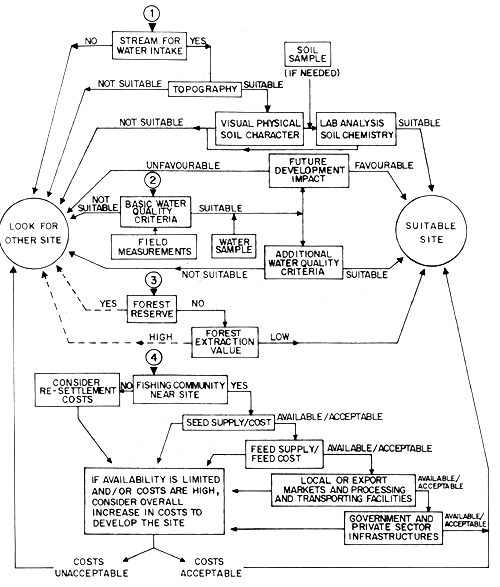
Fig. 5.1 Second stage screening flow diagram — site selection at the field level. O starting points of evaluation processes for (1) engineering aspects, (2) water quality criteria, (3) forestry aspects, (4) socio-economic aspects.
Water supply
a) The availability of an estuary or bay for the water intake channel is a prerequisite for a suitable site. The intake channel cannot be sited on a mudflat of a streambed because tidal currents would fill it with sediments.
b) Stream or bay morphology. The stream should have a rather deep and stable bed so as to maintain an adequate water level at neap tides. A sheltered bay from which water can be withdrawn may also be favourable.
Hydrology
The river discharge is of importance in two ways. If there are seasonal low flow and high water periods, and if pollution loads are a problem, then water analysis should be made in the dry season, at the start of, and in, the wet season. Rainfall records are a key factor in determining stream flow regimes. Flood stages are also important in project siting. Maximum flood stages may be obtained from local residents or from government records, otherwise, an experienced hydrologist would be needed to determine flood stages.
High sediment load may affect P. monodon and may require a sedimentation pond for the removal of suspended solids of the intake water. This is, however, useful only if the settling rate proves to be high enough. Turbidity measurement can easily be done with a secchi disc, and will give good comparable data.
Topography
The area being investigated must be large enough to accommodate the planned pond development. Preferably, it should be large enough to enable later expansion. The optimum ground elevation for the pond construction is discussed in Section 2. The elevation of an area is not a “yes-no” decision. A less favourable elevation implies additional pumping or excavation costs which have to be weighed against benefits of other kinds.
Soil
The experienced aquaculture engineer or aquaculturist can “handtest” the soil of a site to judge the suitability of its physical and mechanical characteristics. A positive finding of soil quality is a prerequisite for further investigation of a site. Several samples of the soil should be taken at appropriate levels for laboratory analysis. The laboratory analysis will substantiate information necessary for the dike and pond construction. Other samples should be analyzed for acidity and potential acidity, to reveal any possibilities for a future acid sulphate condition. Methods for acid sulphate determination are discussed in Kanapathy (1976).
Acid sulphate soil conditions are a main problem in brackishwater aquaculture. If a site is found to possess such a potential problem, it should be seriously considered for rejection. If the watershed accommodates large areas of agricultural activities, pesticide contamination cannot be excluded as a potential water quality problem. It is difficult to measure pesticide contamination in the water. Pesticides may however accumulate in the sediments, from which measurements could then be made.
On-site water analyses
The parameters listed under this heading can be easily measured at the site with fairly simple field equipment. The salinity profile in an estuary during flood and ebb tide is of interest as a measure of pond water intake quality. Depending on rainfall, river discharge and coastal current, an extensive freshwater wedge could be formed so that the salinity at the intake point could be influenced adversely.
Water sample analyses
Several water samples should be taken to obtain indepth information on the biological oxygen demand (BOD), bacteriological contamination (E. coli test) if near human settlements, sediment load, and the settling rates of the suspended sediments. The loads and characteristics of sediment will give information on the necessity of a sedimentation pond, if other parameters are favourable. The presence of a high number of coliforms is an indication of the potential adverse effects of untreated organic sewage from nearby human and associate activities. This therefore, suggests the possible contamination of the cultured fish or prawn stock upon the outbreak of diseases that may be harmful to the survival of the cultured organisms. The occurrence of increasing level of coliforms is also expected to unfavourably affect other essential parameters of a site. As far as possible, a site with high coliform levels should be avoided.
Water pollution risk
Though water quality may be acceptable or good, the risk of pollution accidents arising from activities of industries, agriculture, settlements, nearby shipping lanes, and tanker terminals should be carefully considered. That the above-mentioned activities are in the vicinity of an aquaculture site does not necessarily imply chronic water pollution (though it is very likely), but tanker accidents, pipeline, ruptures, leakage of chemical industrial storages, or wastes of livestocks, are always a possible major danger.
Forest economy
The forester of the survey team should note the flora and zonation of plant life at the envisaged site, and the condition of the stand. Though a site may be situated in a forest reserve, it may not be of high economic value, and therefore, its alternative use for pond culture may be compatible with the overall forest management scheme. Figures for the value based on actual extraction potential, and the timber extraction potential under a future management scheme should be calculated, as well as any imminent value for other utilization.
Ecology
It is very difficult to obtain meristic data on the ecology of the mangrove biotope. Such functions as litter production, leading to nutrient production through decomposition are necessary for the mangrove biotope itself; and the productivity of coastal waters are only generally known. Further, ecological considerations on the inter-relation of mangroves with coastal fisheries, are discussed in Section 5. It should be noted to what extent a proposed pond development will disrupt the water exchange of larger areas of mangrove forest. In this respect, it is considered essential to leave a certain width of mangrove belt between any development area and the sea or river. The width of such a belt is very much disputed, but should be some 100 m at least at the sea front.
The first or second-stage screening of socio-economic parameters for a given site provides a verification and expansion at the field level of many of the parameters which were already investigated during the first-stage screening (see Section 5 and Table 4.1). However, the difference is in the scale involved. While first-stage screening of socio-economic parameters was at the state, or at best, the district level, second-stage screening may have to be at the community or village or level.
Infrastructure
Basically, this item rates a site on the availability of essential services to fish farmers. The assumption here is that in order to induce a fisherman to change over from fishing to fish farming, the alternative engagement must be supported by convenient access to goods and services equal in kind and quantity to those he had as a fisherman.
Thus, a particular site can be rated against the availability of the following kinds of goods and services, as well as the time or cost to obtain them.
Services provided by government:
Water supply (domestic)
Access to shopping facilities for food, clothing and other necessities (public/private transport)
In essence, these criteria can also be used to rate a site on the costs to government to bring the infrastructure to an acceptable standard. In practice, it is likely that at least on the west coast of Malaysia, most sites for coastal aquaculture would be located in close proximity to existing fishing villages. Therefore, providing the necessary infrastructure would be mainly a matter of extending existing ones rather than creating entirely new ones. Another aspect which should be rated is resettlement costs based on the proximity of the aquaculture site to the nearest fishing village. Whether government subsidized or left to the individual, resettlement costs, will ultimately be reflected in project costs.
Verification of input-output data
One of the most critical tasks of the socio-economist in the field survey of a site will be to verify existing input-output data, or to update these data. As has been shown in Section 4, reliable rating of a site on its costs and benefits is very sensitive to the accuracy of the data used in the input and output calculations. The following are the data which should be collected and evaluated for this purpose:
average ex-farm price estimate for cultured species based on price paid to fishermen for the same species and size of individual, and also seasonal fluctuations in prices;
local costs of supplies needed in pond operation (e.g., lime, rotenone, nets, buckets);
cost and availability of seed;
cost and availability of food for cultured organisms. If trash fish is to be the prime fish food source, then attention will have to be paid to the supply available near the site and to the effect of the culture operation's demand for trash fish on the local market prices.
In some cases, the “market” rating of a site will also include the availability of processing and preservation facilities. For example, one rating factor for an exportable culture product such as Penaeus monodon is the proximity to the culture site of export processing, packing, and shipping facilities. Another pertinent point which bears on revenue and site suitability is whether fish farmers could have direct access to such facilities, or alternatively if they would have to market their products through middlemen.
Welfare and general development aspects of site selection
Under this heading a site can be given a rating based on the number of fishermen families which can be made better off in income by the proposed project at the proposed site. Another criterion is the amount by which the aquaculture project at a particular site will reduce local effort on natural fishery resources. In practice for this parameter to have any validity, the number of fishermen transformed into fish culturists would have to be relatively large to make any appreciable impact on capture fishery exploitation rates.
Once the basic work in each of the major site-rating categories (Fig. 5.1) has been completed, it remains to summarize the results in terms of a single rating designation for each of the parameters in the checklist (Table 5.1). The following ratings are proposed:
| O | = | not suitable, if that factor does not conform within the range of acceptable levels set for that parameter |
| M | = | marginal, means that the quality of this factor is, or could be made acceptable, but that it has a low rating otherwise |
| A | = | acceptable, indicates average values |
| G | = | good i.e., the values obtained for this factor are better than average |
Referring again to the checklist (Table 5.1), the evaluator must now take into account the “Present State” and “Future Development” conditions to arrive at a final “Suitability” rating for each category item.
In this rating process (Table 5.1) only single adjectives or cost items are proposed for final entry against the checklist. However, it is important that the rationale upon which these ratings are made be fully documented by the Team. Thus, records will be made of the observations affecting the rating of each parameter so that any succeeding evaluations of a particular site can start from data already compiled. As to the rating in Category 3: “Forestry” it should be pointed out that a low rating from the point of view of forest economy results in high suitability rating for aquaculture.
A final evaluation must now be made. For this it is proposed that the Team acting collectively under the Team Leader now resolve all of the foregoing individual ratings into the four categories shown in Table 5.2.
| Site location Category | Summary Rating | |||
| Not suitable | Marginal | Acceptable | Good | |
| 1) Engineering | ||||
| 2) Water quality | ||||
| 3) Forestry use | ||||
| 4) Socio-economics | ||||
Once the foregoing rating is completed, there will probably be a number of sites with overall “good” ratings. A final selection must then involve officers at a high level of government to take into account geo-political and intangible value consideration to lead to the final site selections.
![]()
![]()
![]()