![]()
![]()
![]()
The guidelines for coastal aquaculture site selection presented in this section and in Section 6 which follows, are essentially proposals not having been completely field-tested. In applying these concepts, therefore, some modifications to fit the actual field conditions may have to be made.
Actual on-site investigations to determine site suitability for aquaculture involving engineering, waterquality and socio-economic studies, are time-consuming and expensive. Therefore, a first-stage site-screening methodology has been developed which greatly reduces the time required to identify promising coastal aquaculture sites on a nationwide basis. After the most promising sites have been located nationally, secondstage screening at the field level is undertaken.
The first-stage screening process accomplishes two things. It provides a means for quickly identifying the most promising areas for coastal aquaculture in the nation, and it also provides a means for ranking these areas. The result is that the actual number of sites which have to be field-investigated is reduced to a workable number.
The approach advocated is to execute the first-stage screening by assembling a site selection team which would work at Fishery Headquarters in Kuala Lumpur. This team should consist of a team leader/coordinator, an aquaculturist, a socio-economist, and a pollution/ water-quality specialist. The team should be supported by secretarial services and one technical assistant for each team member.
The first activity of the team is to assemble a master list and large-scale map plot of all possible coastal aquaculture areas in the nation. For example, for pond culture this would be a listing and plotting of all mangrove areas along the coastline but in much greater detail than shown in Fig. 1. For pen, raft, and cage culture a list of coastal lagoons, large estuaries, and sheltered bays would be prepared and plotted. For cockle culture, coastal mudflats would be plotted and tabulated. With this basic information in hand, the screening and ranking process can begin.
Basically, the parameters for the first-stage screening are physical, geographical, economic, socio-economic, and water-quality characteristics, for which information and data are already available. This information is used in conjunction with maps, tide tables, aerial photographs, and nautical charts. Specific screening parameters, analytical activities, and conclusions to be drawn on the suitability of a given area for coastal aquaculture based on single screening parameters are shown in Table 4.1.
It should be noted that the reliability of the results obtained in the first-stage screening will depend to a great extent on the quality of the materials and information available. For the former, the minimum necessary is large-scale maps of the entire coastline (1:10 000), aerial photographs (recent) at 1:10 000 with the possibility of enlargement to 1:2 000, current nautical charts and port plans, weather and climatological summaries, and the like. For the latter, it will be necessary to assemble documents from other departments within the Ministry of Agriculture, and from other ministries. Therefore, it is recommended that the first-step screening proceed in two phases with the first phase allocated to information assembly (one person) and the second phase to information analysis (the team).
A simplified flow chart outlining the screening procedure for one of the analyses, (pond culture) is presented for illustration in Fig. 4.1. Coastal areas clearly unacceptable, or of questionable suitability for aquaculture are screened out in a step-wise process. The important methodological principle to follow here is to begin the screening process with the most easily applied criterion. For example, (Fig. 4.1) it is much less timeconsuming and much easier to eliminate certain coastal areas because of unacceptable tidal characteristics than to assemble data on water quality or soil quality for the entire coastline. Likewise (Fig. 4.1) it is much easier to research the economic condition of traditional fishermen in a state or district in a government report than to measure the economic climate for aquaculture in the same state or district. The former is a matter of finding one datum point in statistical records. The latter requires much more to accomplish in the way of estimating inputs and outputs (e.g., fish prices, demand, processing and exporting facilities, trash fish costs and availability, and the like) from information which must be gathered from many sources.
| Parameter | Analytical Activity/Action | Interpretation for Site/Area Selection | |
|---|---|---|---|
| Physical and Geographic Parameters | |||
| a) | Characteristics of coastal lagoons, sheltered portions of bays and estuaries | Using large-scale nautical charts, determine the surface areas and bathymetry of coastal lagoons, sheltered portions of bays, and large estuaries. Using coastal pilots and meteorological records determine the incidence of storms, and usual wind directions and velocities for the areas near these systems. | Indicates possible suitability of these systems as sites for pen, cage or raft culture based on depth and weather/climate criteria. |
| b) | Areas and use of coastal mudflats | Using large-scale nautical charts, determine locations and surface areas of mudflats which locations and surface areas of mudflats which might be suitable for the expansion of cockle culture in relation to those banks already in use of reserved. | Shows sites and locations of remaining mudbanks which remaining mudbanks which might be developed as additional cockle culture areas. |
| c) | Mangrove surface area and distribution; estuaries in mangroves | Using aerial photographs, maps and information from the Forestry Department, determine the surface areas of mangroves on a district basis. Distinction should be made between reserved and unreserved mangrove areas. Pinpoint estuarine areas in mangroves and tabulate for each mangrove forest by size. | Provides general locations for pond culture in mangrove areas; with estuaries pinpointed also delimits areas where ponds might be located within mangrove forest. |
| d) | Tidal characteristics | Using tidal tables and medium scale maps, plot the sections of the coastline where tidal ranges are suitable for pond culture. Take into account the influence on the suitability of an area of diurnal and semidiurnal tides. | Demarcates coastal areas where tidal characteristics are favourable for aquaculture in ponds with little or no pumping. |
| Water and Soil Quality | |||
| a) | Industrial pollution | Plot on state or other large-scale maps the locations of industrial estates and mining areas in relation to rivers and estuaries. Note kind of effluent. Also plot shipping lanes in estuaries. | Delimits coastal and estuarine areas probably not suitable for aquaculture because of polluted water supplies. |
| b) | Agriculture pollution | Plot as above but for agro-primary industries (e.g., palm-oil processing plants). | Further delimits coastal and estuarine areas where the risk of pollution is probably great or at least where water quality may be suspect. |
| c) | Domestic pollution | Plot locations of large cities not known to have waste treatment plants on the coast or on rivers and estuaries. | Shows estuarine and coastal areas where domestic pollution may prejudice water quality for culture purposes. |
| d) | Soil quality | Consult soil and geological maps to identify coastal areas where the soil iron content is likely to be high. | Provides an indication of where the most severe acid sulfate soil conditions may be encountered along the coastline. |
| Economics and Socio-Economics | |||
| a) | Economic status of small-scale fishermen | Tabulate by district the numbers and net incomes of traditional fishermen. | Indicates the districts of the country where traditional fishermen are most in need of assistance and economic uplifting. |
| b) | Economic climate for culture activities | Investigate market price structure, demand, feed costs and other input/output parameters for cultured fish products on a state by state, district, or large city basis. | Shows in which areas of the country culture operations are likely to be most profitable and therefore where the greatest number of fishermen can be transformed into fish farmers per unit cost. |
| c) | Status of traditional fishery resources | Assess the status of the stocks usually exploited by small-scale fishermen on a state by state basis. | Indicates in which states aquaculture can be best used to reduce fishing pressure on traditional stocks by transforming fishermen to fish farmers. |
| d) | Mangrove utilization patterns | Within the mangrove forests in each state or district, determine which areas are most used or most valuable for forestry products. Also pinpoint locations of fishing villages in mangrove areas and tabulate their population sizes | Delimits mangrove areas already in use with relatively high value for purposes other than aquaculture. Provides an indication of the need for resettlement of fishermen when they become fish farmers. Also indicates presence of basic goods and services (e.g., markets, transport, communication (roads, water)). |
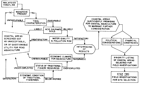
Fig. 4.1 Flow chart illustrating the first stage screening process used to locate promising areas for pond culture in mangroves.
Fig. 4.1 shows only two outcomes for retaining or screening out an area (e.g., “favourable” or “unfavourable” with regard to water-quality). In practice the ratings would be more expressive of the degree of suitability or unsuitability of an area (e.g., unaccetable, marginal, acceptable, good) so that the overall rating of a given area is made easier for final selection.
When all coastal areas have been evaluated against each parameter, the next step is the interfacing of results. This is illustrated schematically in Fig. 4.1 as part of the overall screening process. At this point, all those areas which have received a rating of “acceptable” or “good” for all parameters are tabulated. These are the areas of the nation which hold sufficient promise for coastal aquaculture development so as to warrant further consideration. This consideration is in the form of an evaluation, area by area, by all team members together. The objective is to rank or prioritize each area according to its overall suitability for coastal aquaculture. There can be no hard and fast rule here for decision-making. Much will depend on the relative weight given to, say, pond culture versus cage culture, or to, say, welfare considerations as opposed to considerations of economic efficiency as rating and ranking criteria. However, the end product will be a list in which each coastal area receives a rank.
At this point, the results of the ranking will be reviewed at a level higher than that of the team. Overriding political considerations and financial constraints will enter the decision-making process during this high-level review. For example, given a limited quantity of funds available for the development of coastal aquaculture, installations may be distributed so that each coast has one or, two development areas.
In any case, a short list will result from this process from which the most suitable sites will be selected for field investigations. Field investigations of these coastal areas for aquaculture constitute stage two of the site selection methodology.
The objective of this section is to show that the rational use of Malaysia's mangroves is very much in the interests of the Division of Fisheries and the MAJUIKAN, and therefore an important consideration in coastal aquaculture site selection. The rationale for this statement is, in brief, that mangrove forests provide a number of advantages over other kinds of coastal areas for pond culture sites; moreover, mangrove forests are also important in maintaining the productivity of coastal fishery resources. The mangrove forest area is decreasing rapidly in Malaysia mainly where future coastal aquaculture development is likely to be most intensive. These statements are elaborated below and in a following section some guidelines are presented for pond site selection in mangrove areas.
These are that there are little or no land acquisition costs (land is mainly in government reserves). Mangrove trees shield ponds from erosion by wave action and from damage by storms. Physical/mechanical characteristics of soild in mangrove areas are usually favourable for pond construction. The low elevation of mangrove lands ensures that excavation and water supply costs in minimal, and finally, multiple-use conflicts in land acquisition are few because the extraction of forest products represents the only readily measurable use of mangrove forests.
Much attention has been drawn to the apparent relationship between mangrove forest surface area and fishery yields from adjacent sea areas, particularly for shrimp fisheries (e.g., MacNae (1974) for the Indo-Pacific Region, Martosubroto and Naamin (1977) for Indonesia, and Turner (1977), worldwide). A similar relationship can be shown for Peninsular Malaysia in which shrimp yields for most states appear to correlate well with their respective mangrove surface areas (Fig. 4.2). However, there has as yet been no rigorous scientific proof of the degree, if any, that prawns or finfishes are dependent on mangrove systems for the completion of their life cycles. Said another way, there is no evidence yet available which indicates that the population of prawn or finfish species would be adversely affected if the mangrove ecosystems were removed.
Nevertheless, it has been demonstrated, that many organisms of commercial importance do use mangroves and adjacent estuarine areas as feeding, breeding, and nursery areas. Table 4.2, for example, lists finfish, crab and prawn species known to have an association with Malaysian mangroves and their catch and corresponding retail value for the West Coast of the Peninsula. The criterion of association was the presence of juveniles or fry in mangrove areas. This may be indicative that the mangroves provide a nursery function. In summary, the compilation suggests that about 28 percent of the West Coast catch by weight is made up of species associated with mangroves. The retail value of the West Coast mangrove-associated species, however, amounts to about 55 percent in the retail value of the total Peninsula catch. This is because a large proportion of the high value West Coast prawn catch consists mainly of species which use mangroves as nursery areas (see for example, MacNae (1974); Mohamed and Rao, (1971); SCSP/GEN/76/6, and Chong (1980). When considered in terms of the remaining mangrove and adjacent estuarine surface area on the West Coast1, about 176 000 ha in total, the weight of the mangrove-associated West Coast catch is equivalent to 715 kg/ha/yr and the value amounts to about 3 760 $M/ha/yr.
Therefore, even though an essential dependence between mangroves and fisheries has yet to be demonstrated, it would be negligent to ignore the value of mangrove forest as a highly productive coastal system which provides food and shelter for many fishes, crustaceans and molluscs which, in turn, constitute valuable fishery resources.
Ong (1978) estimates that within the last 20 years 20 percent of the mangrove area on the Peninsula has been lost. He also presents data to show that even in areas where mangroves are managed for forestry products, a replanting backlog exists.
In East Malaysia, some 5 000 ha of mangrove per year are being cleared with little serious effort at reforestation (Ong, 1978).
The Ministry of Agriculture has plans for the development of some 27 000 ha of land for brackishwater culture (see Appendix 5, p.7). Similarly, Ong (1980) mentions 30 000 ha as a target for development of brackishwater fish farms.
| STATE | PRAWN LANDINGS (T) | MANGROVE RESERVE KM2 |
|---|---|---|
| PERLIS | 2204 | 0 |
| KEDAH | 7086 | 91 |
| PINANG | 3101 | 4 |
| PERAK | 25839 | 414 |
| SELANGOR | 22154 | 314 |
| N. SEMBILAN | 15 | 15 |
| MELAKA | 77 | 1 |
| JOHOR | 4808 | 261 |
| KELANTAN | 225 | 0 |
| TRENGGANU | 1050 | 10 |
| PAHANG | 989 | 24 |
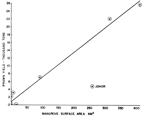
Fig. 4.2 Prawn yield in Peninsular Malaysia in 19781 as a function of reserved mangrove surface area
| ISSCAAP Group | Local Name | English Name | Scientific Name | Landings1 (tons) (tons) | Value Category2 | Value3 (000 $M) | Ass. Cat.4 | Ref.5 | Remarks/References6 | |
| 24. | Shads | Kebasi/Selangat | Gizzard shad | Anodontosoma chacunda | 966 | III | 1 372 | Diadromous fishes | ||
| Milkfishes | Paput | Shad | Pellona spp. | 562 | II | 1 590 | ||||
| Etc. | Beliat Mata | Slender shad | Ilisha elongata | |||||||
| 25. | Misc. | Siakap | Sea perch | Lates calcarifer | 299 | ? | 846 | |||
| 31. | Lidah | Tongue soles | Cynoglossus spp | 2720 × 0.5 | III | 1 931 | J | 6, 5 | Juveniles of tongue soles in estuaries (5) | |
| 33. | Biji Nangka | Goatfishes | Upeneus spp | 596 | III | 846 | J | 5 | U. sulphureus, most common goatfish sp in Malaysia (3); has juveniles in estuaries (5). | |
| Daun Baharu | Spotted batfish | Drepane punctata | 84 | III | 119 | J | 5 | - | ||
| Dengkis/Debaun | Rabbitfishes | Siganus spp | 21 | III | 30 | J | 4 | Common in coastal waters (3). | ||
| Duri/Pulutan/Utek | Marine catfishes | Tachysurus/ Arius spp | 2863 × 0.8 | III | 3 252 | F | 1 | About one half of the Papua New Guinea Aridae (5) and 80% of the Aridae listed for the N. Indian Ocean (6) are estuarine. | ||
| Gelama/Tengkerong | Croakers | Sciaena spp | 6116 × .67 | III | 5 819 | J | 5 | Of the 11 spp listed for Malaysia by (3), 3 spp are common in estuaries and commercially important. Two of the three are known to spend most of their life in eurylaline waters and their juveniles are found there (5). | ||
| Johnius spp | ||||||||||
| Gerut-gerut | Grunters | Pomadasys spp | 1346 × 0.5 | III | 956 | F, J | 1, 5 | P. hasta; one of two common species in Malaysia (3) | ||
| Jenahak | Mangrove snapper | Lutjanus argentimaculatus | 1 585 | II | 4 486 | J, * | 4, 5 | - | ||
| Kerapu | Groupers | Epinephelus spp | 3504 × 0.4 | I | J | 4 | Fry of Epinephelus spp. listed in mangrove by (4); 5 spp of Epinephelus are economically important and of these 5, 2 spp are found in estuaries as well as coastal waters (3). | |||
| Plectropmus spp | ||||||||||
| Malong | Conger eels | Muraenesox spp | 2176 × 0.5 | III | 1 545 | P | 3, 6 | M. cinerus occurs in estuaries (3, 6). | ||
| Merah | Red snappers | Lutjanus spp | 3136 × 0.5 | II | 4 437 | - | ||||
| Remong/Kunyit | Snappers | Lutjanus spp | 84 × 0.5 | III | 60 | J, * | 4, 5 | - | ||
| Semilang | Catfish eels | Plotosus spp | 636 | III | 903 | F,*J,* | 2,5,6 | P. canius | ||
| Puntang/Danar/Bulus-bulus | Whitings | Sillago sihama/S. maculata | 84 | ? | 119 | J | 5 | S. sihama; this is the most common spp (3). | ||
| 34. | Jacks, | Bawak puteh | White pomfret | Pampus argenteus | 3885 × .33 | I | 7 423 | J | 6 | P. argenteus is one of 3 pomfrets common in Malaysia (3) |
| Mullets, | Belanak/Kedera | Mullets | Mugil spp | 1 476 | III | 2 096 | F,J | 1,4,5 | Liza subviridis; L. melinoptera; most members of this family use estuarine areas as nurseries. | |
| Sauries, | Kurau/Senangin/ | Threadfins | Polynemus spp | 941 | I | 5 448 | F,J | 1,5 | P. tetradactylum; all species are estuarine and coastal (3) | |
| Etc. | Talang | Queenfishes | Chorinemus spp | 157 | III | 223 | J | 5 | C. lysan is one of two Malaysian species known to have juveniles in estuarine waters. | |
| leather-skins, | ||||||||||
| leather jackets | ||||||||||
| 35. | Herrings Sardines Anchovies | |||||||||
| Etc. | Bilis | Anchovies | Stolephorus spp | 34 270 | I | 198 423 | J | 4,5 | S. commeronsoni (assume all are Stolephorus in this category. | |
| Anchoviella spp | ||||||||||
| Bulan | Tarpon | Megalops cyprinoides | 0 | - | - | *M,J | 5,6 | - | ||
| Tamban | Sardines | Clupea spp | ||||||||
| Sardinella spp | 4 867 | III | 6 911 | J | 4 | Sardinella spp. | ||||
| (Fishes Sub-Total) | 60 346 tons | $256 950 | ||||||||
| 42. | Seaspiders, | Ketam Laut | Swimming (blue) | |||||||
| crab | Portunnus pelagicus | 3254 × 0.5 | III | 2 310 | (Assume one half of crab catch is S. serrata) | |||||
| Crabs | Ketam Batu | Mangrove crab | Scylla serrata | |||||||
| 45. | Shrimps | Udang | Prawns (large) | Penaeus/Metapenaeus | 6 398 | 105 887 | J | (See text for references for prawns) | ||
| (medium) | spp, etc. | 21 748 | 183 988 | J | ||||||
| (small) | 28 540 | 101 763 | J | |||||||
| 56 680 | 391 763 | |||||||||
| Prawns | Udang Baning | Sergestid shrimps | Acetes spp. | 6 950 | III | 9 869 | F | 1,2 | A. erythraeus | |
| GRAND | TOTALS | 125 604 tons | $M660 892 | |||||||
1 Because catches of some fishes are presented in the official Malaysian statistics only to a genus level when more than one fish species contributes
to the catch, it has been necessary to make an adjustment for the catch of those species within a genus which are mangrove-associated. This
adjustment is rather subjective. See, for example, the remarks made for Gelama/Tengkerong (Jewfish) and Ketam Laut (Crab).
2 Catch and value data, species names, and general table organization are from Annual Fisheries Statistics, for 1979.
3 Malaysian ringgits ($M)
4 Mangrove Association Category: J - fry or juveniles collected from mangrove areas; F - food studies have shown that the species directly or
indirectly utilizes food produced in mangrove areas; * predominantly estuarine species with main populations in mangrove areas; M - mainly marine,
but can have small populations present in mangrove areas.
5 (1) Sasekumar (1980); (2) Sasekumar (1977); (3) Scott (1959); (4) Angeles (1978); (5) Liem and Haines (1977); (6) Shubnikov (1977).
6 Species mentioned in this column are mangrove-associated; numbers refer to literature sources above.
Compared with the total mangrove area in the country at some 650 000 ha, the utilization of 30 000 ha for coastal aquaculture amounts to only about 5 percent of the total. However, from Fig. 1 and Table 4.3, it is clear that mangrove distribution along Malaysia's shorelines is extremely uneven. For example, Peninsular Malaysia has about two-thirds of the nation's shoreline, but less than 20 percent of the total mangrove area. In contrast, Sabah has a relatively short shoreline but more than 50 percent of country's mangrove forest. Two states on the Peninsula apparently have no mangroves remaining at all.
| State | Hectares | |
|---|---|---|
| Peninsular Malaysia1 (See Fig. 1) | Perlis | - |
| Kedah | 9 065 | |
| Pinang | 412 | |
| Perak | 41 388 | |
| Selangor | 31 416 | |
| Negeri Sembilan | 1 450 | |
| Malacca | 78 | |
| Johor | 26 055 | |
| Pahang | 2 409 | |
| Trengganu | 984 | |
| Kelantan | - | |
| Sub-Total | 113 257 | |
| East Malaysia | Sabah2 | 365 345 |
| Sarawak2 | 173 614 | |
| Grand Total | 652 216 |
1 Peninsular Malaysia estimates, with the exception of Pinang, taken
from Sasekumar (1980). Pinang estimate pers. comm. Hambal
Hanafi. All are forest reserve areas.
2 Sabah and Sarawak estimates from Gomez (1980).
A number of factors points to the West Coast of Peninsular Malaysia as a focal point for the development of coastal aquaculture. Among these are the relatively large numbers of “surplus” traditional fishermen in need of economic uplifting there, overexploited traditional fishery resources, a relatively dense human population (and subsequent high demand for fishery products), and an already existing infrastructure for aquaculture development. Therefore, the use of mangrove areas as sites for pond construction for coastal aquaculture development is likely to represent an increasingly important use of mangroves in the future.
In summary, mangroves provide attractive sites for the development of pond culture, and also function to maintain highly productive and valuable capture fisheries. However, mangroves are rapidly disappearing from the nation's shorelines. For both of these reasons, it it clearly advantageous for the Malaysian Fisheries Division and the MAJUIKAN to act together to promote the conservation of the nation's remaining mangrove resources for fishery uses. To this end, a number of guidelines have been formulated for coastal aquaculture pond site selection so that the development of culture operations will result in a minimal loss and disturbance to the remaining mangroves. The guidelines are as follows:
(1) Preservation of a functional mangrove ecosystem.
As has been shown above, preservation of mangroves is important both to provide sites for culture fishery development and to maintain capture fishery resource production potential. Thus, for the latter, mangroves must be left to continue to function in a highly productive manner. For the former, at least a protective strip of mangrove must be maintained between the seashore and pond sites. To ensure that mangroves continue to function in these ways, an overall guideline is that the pond area to be devoted to pond culture farm development should be small in relation to the area of mangrove in which the farm is located.
(2) Use of reclaimed land. Wherever possible, already reclaimed, but presently unused areas should be given first priority as pond sites. For example, it appears that many paddy fields, which are located on reclaimed mangrove lands, are presently not being utilized. These should be considered as possible pond sites. An advantage here is that the clearing costs for fishponds would be minimal or negligible.
(3) Marginally productive areas. Those areas in the mangrove forest likely to contribute most to capture fisheries by providing feeding and nursery areas, are the portions of the forest which are most deeply and frequently inundated by tides. This corresponds to the forest areas which are lowest in elevation and therefore, closest to the sea. Thus, to reduce possible impacts on capture fishery resources, wherever possible, ponds should be sited towards the landward side of the mangrove forest, or if possible, where the mangrove interfaces with other vegetation types of minimal value. Use of the landward side of the mangrove forest for pond shrimp culture is practised with success in Thailand and in Ecuador. Apart from conservation of mangrove, an additional benefit that is likely to occur is that the farms would be closer to existing facilities such as roads, electricity and potable water. Thus, site development costs could be reduced by such location. The disadvantage of such a location for the ponds is that more pumping or canal construction might be required because the landward side of the forest is more elevated than the seaward side.
The thrust of this report is the development of a methodology for coastal aquaculture site selection. However, it is evident that the first-stage screening process could also be used separately to provide an inventory of Malaysia's coastal aquaculture potential. This is because one of the outputs of the first-stage screening is a list of all of those areas in the country which are rated “acceptable”, or “good” for coastal aquaculture development.
Such information is not only invaluable for aquaculture planning but also of great use for making decisions on overall fishery policy, and for integration of capture and culture fishery planning and development. Some examples of the uses which could be made of an inventory of coastal aquaculture potential, coupled with other information, are the following:
Accurately predict the potential of coastal aquaculture to contribute to the overall fishery output in terms of yield and value.
Based on (1) above predict the numbers and rate at which traditional fishermen can be transformed into fish farmers, given known amounts of government funds or coastal aquaculture development. This prediction also has important implications for capture fishery management policy in that the rate of reduction of fishing effort through the transfer of fishermen to fish farming, will determine the amount of funds to be allocated for the management of traditional fisheries.
Given the locations and approximate areas suitable for various kinds of coastal aquaculture (pond, cage, pen, raft, bottom) with various species available (seabass, tiger prawn, groupers, mussels, oysters, cockles), combined with approximate estimates of development costs, market conditions, and income (as shown in Sections 3 and 4), it should be possible to make a national policy for aquaculture development which would dictate which kinds of culture and species combinations could be most advantageously pursued for the future, and where in the country this development should be pursued in terms of overall economic efficiency, or in terms of welfare (i.e., the amount of investment potential which exists, and the kinds and quantities of technical and financial assistance required to achieve the potential).
![]()
![]()
![]()