![]()
![]()
| Post | Experience, etc. | No. Employed |
|---|---|---|
| Brief Technical Adviser | Extensive international | 1 |
| F.A.O. Expert | Overseas experience | 1 |
| Supervisor | Extensive rational | 1 |
| Specialist Officers | Trained to degree standard | 3 |
| Fishery Extension Officers | Based at Fisheries Unit | 3 |
| Fishery Extension Officers | Based in three provinces | 3 |
| Secretary | Clerical skills and typing | 1 |
| Office orderly | Miscellaneous unskilled duties | 1 |
| Driver | 1 | |
| TOTAL | 15 |
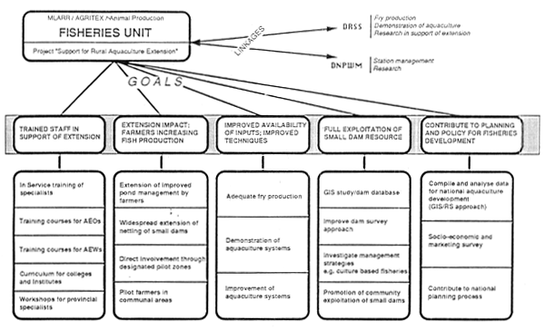
AGRITEX/FAO/UNDP PROJECT ZIM/88/021 “SUPPORT FOR RURAL AQUACULTURE EXTENSION”
| AGRITEX | |
| “Seminar group on GIS” | - Mr. B. de Gong Mr. G. Jiprie, Mr. A. Lilime, Mr. B. Hobbs |
| Mr. A. Andreasson | - Programme Manager - ALCOM |
| Mr. Ataman | - GIS Consultant - FAO, Rome |
| Mr. J. Barrett | - Attached to Tsetse Control Branch - University of Zimbabwe |
| Mr. S. Chimbuya | - Senior Ecologist, Dept. of National Parks and Wild life |
| Mr. Cuta | - “Dom Database” specialist - MEWRD |
| Dept. of Natural Resources | - Mr. Myofre, Mr. R. Mukwanda, Mr. G. Kurane. |
| Dept. of Surveyor-General | - Mr. F. Chunga, Mr. A Fussell, Mr. K. Philip, Mr. S. Banda, Mr. R. Movina, Mr. B. Mdambakuwa. |
| Early Warning | |
| Unit-AGRITEX | - Dr. Mathema. Dr. Benadi |
| Fisheries Unit - AGRITEX | - Mr. Iambava, Mr. W. Bind, Mr. E Shonhuiva, Mr. Chimowa |
| Mr. Goodwin | - Secretary, National LIS/GIS Coordinating Committee, |
| c/o University of Zimbabwe | |
| Mr. Gowera | - GIS Specialist, System Ltd. |
| Mrs. P. Haggerty | - Nutritionist, FAO, Rome |
| Dr. B. Hight | - Senior Aquaculturist - ALCOM |
| Mr. J. Holland | - “Dom Database” conversion - MEWRD |
| Mr. T. Jayne | - Dept. of Agricultural Economics - Univ. of Zimbabwe |
| Mr. Kahwa | - Bhaiman - National Steering Committee on Food and Nutrition - AGRITEX |
| Dr. H. Kaufmann | - Programme Manager, NRSF - Geological Survey |
| Mr. P. Loth | - Remote Sensing Specialist - Dept. of Meteorological Service |
| Mrs. Malaba | - Social and Economics Section - C.S.O. |
| Mr. C. Masterton | - Dept. of Land Survey, Univ. of Zimbabwe |
| Mr. Muyaka | - Agricultural Section C.S.O. |
| Mr. C. Nugent | - Chief Technical Adviser - Fisheries Unit - AGRITEX |
| Dr. V. Odenyo | - Chief Technical Adviser - Dept. of Meteorological Service |
| Mr. A. Pilime | - Land Use Planning - AGRITEX |
| Mrs. Tagwerti | - Chief Nutritionist - Min. of Health |
| Mrs. V. Ushenwokunze | |
| - Obatolou | - Dept. of Veterinary Science, Univ. of Zimbabwe |
| Mr. U. Wijkström | - Aquacultural Economist - FAO, Rome |
Burrough, P.A. (1986) “Principles of Geographical Information Systems for Land Resources Assessment” Blarendon Press, Oxford, England
FAO (1989) “Support for Rural Aquaculture” Project Document for project ZIM/88/021, ACC/UNDP, FAO Rome
FAO (1991) “Programme of Technical assistance to the Dept. of Agriculture, Technical and Extension Services (AGRITEX)” Project Document for project ZIM/91/005, ACC/UNDP, FAO, Rome
Haggerty, P.A. (1990) “Potential for Using the Geographical Information System to Integrate Food and Nutrition Data with Fishery Resource Data: Assessment Studies in Zambia and Zimbabwe” Report of a consultancy for project GCP/INT/467/NOR, FAO, Rome
Kent, G. and Josupeit, H. (1989) “The Contribution of Fisheries to Alleviating Malnutrition in Southern Africa” FAO Fisheries Circular No. 818. FAO, Rome
Kidd, D.W., R.H. Maxwell and P.H. Sloane (1991) “Mission Report for the Republic of Zimbabwe on Programme of Technical Assistance to AGRITEX (Project ZIM/90/003)” FAO, Rome
Meaden, G.J. and J.M. Kapetsky (1991) “Geographical Information Systems and Remote Sensing in Inland Fisheries and Aquaculture” FAO Fisheries Technical Paper No. 318, FAO, Rome
Ontario Ministry of Natural Resources (1991) “Project Management Plans - Research and Technical Branch Project” Toronto, Ontario, Canada, 1991
Pooley, M.R. (1991) “GIS and Remote Sensing Feasibility Study in the Western Region of Zimbabwe” Report Submitted to the Natural Resources Institute - Gan. 1991
Tyrie, G.R. (1991) “Position Paper for Project ZIM/86/018: Strengthening Land Use Planning in the Zambezi Valley” Paper presented at a Provincial Forum - 29–30 April 1991 in Morondeva, Zimbabwe
Wood-Sichra, U. (1991) “Strengthening Land Use Planning - Zimbabwe: Computerized Land Use Planning - Requirements and Preparations” Consultants draft report for project ZIM/86/018 - Harare, Zimbabwe - May 1991
| MAP “LAYER” AND SOURCE | COMMENTS | |
| 1. | Administrative Boundaries | |
| a) | 1:1,000,000 DSG Administrative areas (1982) | Shows main divisions down rural boundaries and municipalities but NOT wards. AGRITEX holds alter maps showing ward boundaries by province. Some changes have taken place since 1982. Some data is gathered to ward level but census data is gathered by enumeration district. |
| 2. | Agro-ecological zones or Farming types | |
| a) | 1:1,000,000 DSG natural regions and farming areas (1984) | Very generalised. Shows types of farming area based on rainfall (mainly) - by 6 major categories. Older versions of this map appear to be more detailed. |
| b) | FAO-1:5,000,000 World D/B IIShown by enumeration areas in 9 classes. Urban area densities not shown and data related to 1982. There is also a population distribution map - one dot per 500 in rural areas plus proportional circles for urban areas. Will be updated after 1992 census. | |
| 3. | Dam site location | |
| a) | 1:250,000 DSG topographic | The 1:250,000 sheet shows dams down to approximately 5 hecares in size and gives good coverage. The 1:50,000 sheet plots dams down to about ½ hectare. This is a very good source of data - extremely accurate. |
| b) | 1:50,000 DSG topographic | |
| 4. | Pattern of land holdings | |
| a) | 1:1,000,000 DSG land classification (1979) | Shows main subdivisions of land, e.g. large commercial farms, small commercial farms, resettlement land, communal land, state land, parks, other. Dated but otherwise could be used with care. |
| 5. | Population density or distribution | |
| a) | 1:1,000,000 DSG density of rural areas (1982) | Shown by enumeration areas in 9 classes. Urban area densities not shown and data related to 1982. There is also a population distributio map - one dot per 500 in rural areas plus proportional circles for urban areas. Will be updated after 1992 census. |
| 6. | Relief and Slopes | |
| a) | 1:1,000,000 DSG relief (1984) | Counter interval on 1:1,000,000=300 metres Counter interval on 1:250,000=100 metres Counter interval on 1:50,000=20 metres Very accurate and comprehensive. I have also seen a slope map at 1:1,000,000 - source unknown (see NRSF) |
| b) | 1:250,000 DSG topographic | |
| c) | 1;50,000 DSG topographic | |
| 7. | River location | |
| a) | 1:1,000,000 DSG physical or hydrological (1984) | Well documented for all country down to 1:50,000, but no indication of perennial nature of flow. Dpt. of Water Resources has data on flow from several hundred gauging stations. |
| b) | 1:250,000 DSG topographic | |
| c) | 1:50,000 DSG topographic | |
| d) | 1:5,000,000 FAO - from W D/B II | |
| 8. | Soils | |
| a) | 1:1,000,000 DSG provisional soil map | Recently out of print but copies held by AGRITEX. Very generalised in that soil maps are inefficient on helping to determine optimum pond location at a macro-soil. More detailed information from Dept. of Research and Specialist Services - Mr. Knynda (Pedology) |
| b) | 1:5,000,000 - FAO Rome W D/B II | |
| 9. | Transport | |
| a) | 1:1,000,000 DSG (several maps show roads and railways) | Main roads and all rail links shown on 1:1,000,000 sheet. Minor roads additionally shwown on larger scale maps. Accurately plotted - reliable data. |
| b) | 1:250,000 DSG topographic | |
| c) | 1:50,000 DSG topographic | |
| d) | 1:5,000,000 FAO, Rome W D/B II | |
| PARAMETER | COMMENTS | |
| 1. | Agglomeration | This constitutes groupings of fish producers who may help one another. The data could eventually be inferred by plotting from the dam dom database, or a pond database, all locations where production was known to occur. |
| 2. | Availability of feeds | This is very difficult to establish since the is virtually no regular or reliable source of crop by-products. Sources of processed fish feeds are easily mapped. |
| 3. | Availability of fish seed | Only very crude indications could be mapped. Though the six main hatcheries could be plotted, most seed is probably obtained by “trading” between neighboaring fish producers. The actual distribution of producers could therefore be a good “proxy”. |
| 4. | Availability of manures | Maps showing farming type distributions could give a clue to this. AGRITEX should have more accurate data on animal distributions. The location of “feedslots” could be useful. |
| 5. | Location of fishery extension workers | Some 60 of AGRITEX's extension workers have some fisheries training. It seems that their duty location could be mapped. |
| 6. | Markets | Population density and distributions could provide fair, but dated data. This could be used in conjunction with maps showing communal lands to show “target markets”. The limited processing plants are easily plotted. No data on purchasing power of markets. |
| 7. | Water quality | Though this is seldom a problem - though there is recent news - paper evidence of pollution - but little reliable data is available. Areas near large towns, mining areas or intensive farms could be larger. |
| 8. | Water temperatures | A “proxy” measure can be obtained from average air-temperatures, temperature ranges - and altitude can also be a good indicator. |
| GENERAL INFORMATION | Dam Number : 115 |
| Location Code | : 1 0 3 1 02 0 99 | ||||
| Province | : MASHONALAND CENTRAL | Administrative District | : GURUVE | ||
| Council | : GURUVE | DC | Division | : CHIPURIRO | CL |
| Ward/Location | : UNSPECIFIED | WARD | Locality | : SIPOLILO TTL | |
| Grid Reference | : T S 544 582 | Map Number | : 1630D1 | ||
| Funding Agency | : | Implementing Agency | : MEWRD | ||
| Dam Name | : | Hydro Zone | : C | ||
| River Name | : DANDE | Hydro SubZone | : H1 | ||
| Site Number | : 33 | ||||
| Date Completed | : | Water Right Number | : 10665 | ||
| Natural Region | : I | W.D.A.C. Code | |||
| Water Usage | : [ ] Urban | [ ] Agricultural | [ ] Primary | ||
| [ ] Industrial | [ ] Institutional | [ ] Other | |||
| [ ] Mining | [ ] Government Water Supply Station | ||||
| Place Supplied | : | ||||
| Owner Code | : MEWRD | ||||
| Maintenance Code | : MEWRD | ||||
| TECHNICAL PARAMETERS |
| Catchment Area | : | 0.0 | km2 | Design Flood | : | 0 | m3/5 |
| Mean Annual Runoff | : | 40 | mm | Coefft of Var (MAR) | : | 120 | % |
| Dam Construction Code | : UNKNOWN | ||||||
| FS Capacity | : | 340 | th.m3 | FS Surface Area | : | 0.0 | ha |
| Live Capacity | : | 340 | th.m3 | Height of Dam Wall | : | 0 | m |
| 10 % Yield | : | 0 | th.m3 | FS Water Depth | : | 0 | m |
| Risk Factor for | |||||||
| Alternative Yield | : | 0 | th.m3 | Alternative Yield | : | 0 | % |
| Remarks | : | ||||||
| DATABASE ADMINISTRATION DETAILS |
| Created by | Last Updated by | Verified by | Date Printed |
| 09/08/1989 JN | 11/10/1989 AG | 25/02/1991 SYS | April 12, 1991 |
| DAM NAME | RIVER NAME | GRID REF | MAP NO | DATE COMPL | USAGE VIMAIGPO | PLACE SUPPL | OWNER CODE | CONSTR CODE | FS CAPA | FS AREA | WALL HT | FS DEPTH |
| mm/yy | (th m3) | (ha) | (m) | (m) | ||||||||
D A M M A I N T E N A N C E L I S T I N G
| Report selection criteria: | ||
| Generated: | April 10, 1991 | at 6:44 PM |
MAINTENANCE AGENCY: OTHER
| PROVINCE: UNSPECIFIED | ADMIN DISTRICT: HYDRO | AUTHORITY: HYDRO DC | ||||||||
| DIVISION: HYDRO1 CL | ||||||||||
| LOCATION: HYDRO DSC | LOCATION CODE: | 9.11.111.111 | ||||||||
| 703462 | 2032B3 | 00/00 | PRIVA UNKNOW | 0 | 0.0 | 0 | ||||
| SUMMARY: HYDRO DSC | 1 DAMS | Average: | 1234,176 | 0.0 | 0 | |||||
| Maximum: | 0 | 0.0 | 0 | |||||||
| SUMMARY: HYDRO CL | 1 DAMS | Average: | 1234,176 | 0.0 | ||||||
| Maximum: | 0 | 0.0 | ||||||||
| DIVISION: HYDRO3 CL | ||||||||||
| LOCATION: HYDRO3 DSC | LOCATION CODE: 9.11.113.111 | |||||||||
| 629082 | 2028D1 | 00/00 | A | PRIVA UNKNOW | 20 | 0.0 | 0 | |||
| 796134 | 2028D1 | 00/00 | A | PRIVA UNKNOW | 0 | 0.0 | 0 | |||
| SUMMARY: HYDRO3 DSC | 2 DAMS | Average: | 20 | 0.0 | 0 | |||||
| Maximum: | 20 | 0.0 | 0 | |||||||
| SUMMARY: HYDRO3 CL | 2 DAMS | Average: | 20 | 0.0 | 0 | |||||
| Maximum: | 20 | 0.0 | 0 | |||||||
| DIVISION: HYDRO4 CL | ||||||||||
| LOCATION: HYDRO4 DSC | LOCATION CODE: 9.11.114.111 | |||||||||
| SHANGANI TRIB | 582085 | 1929C4 | 00/00 | A | PRIVA UNKNOW | 5 | 0.0 | 0 | ||
| NQUAESSE | 425615 | 2028A2 | 00/00 | A | PRIVA UNKNOW | 132 | 0.0 | 0 | ||
| 354694 | 2028A2 | 00/00 | A | PRIVA UNKNOW | 89 | 0.0 | 0 | |||
| SUMMARY: HYDRO4 DSC | 3 DAMS | Average: | 75 | 0.0 | 0 | |||||
| Maximum: | 132 | 0.0 | 0 | |||||||
A C A W I D S R E P O R T
Generated April 10, 1991 at 7:21 PM
Description:
| Province : UNSPECIFIED | Admin District : HYDRO | |||
| Authority : HYDRO | DC | |||
| Division : HYDRO1 | CL | Location : HYDRO | DSC | Code: 9 1 1 1 11 1 |
| Map Number | Grid Reference | Dam Number | Locality | Dam Name | River Name | Hydro Zone | |||||
| 1731D3 | V | R | 440 | 100 | 2560 | BOTHAS RUST ESTATE | NYAMBUYA | D IY3 | |||
| 1732C2 | V | R | 398 | 520 | 3300 | BUDJIGA TRIB | NYAGADZI TRIB | D R4 | |||
| 1828C4 | 295 | 110 | 7438 | MANASA | A S2 | ||||||
| 1828C4 | 562 | 68 | 7439 | MATCHENA | SHANGANI TRIB | A S2 | |||||
| 1828C4 | 418 | 136 | 7440 | SINGWANGOMBE | SINGWANGOMBE | A S2 | |||||
| 1829C3 | Q | K | 196 | 186 | 7132 | THE EXCHANGE | EXCHANGE BLOCK | GWERU | A S3 | ||
| 1929B2 | R | J | 63 | 797 | 2326 | KWEKWE TTL | MLEZU | C VN3 | |||
| 2032B3 | 703 | 462 | 6641 | F FUZ | |||||||
| Division : HYDRO3 | CL | Location : | HYDRO3 | DSC | Code: 9 1 1 1 13 1 | ||||||
| 2028D1 | 634 | 55 | 8501 | B BT4 | |||||||
| 2028D1 | 629 | 82 | 8503 | B BT4 | |||||||
| 2028D1 | 796 | 134 | 8505 | B BT4 | |||||||
| 2129B3 | 689 | 434 | 8229 | B VZ1 | |||||||
| Division : HYDRO4 | CL | Location : | HYDRO4 | DSC | Code: 9 1 1 1 14 1 | ||||||
| 1929C4 | 582 | 85 | 1226 | SHANGANI TRIB | A S6 | ||||||
| 2028A2 | 425 | 615 | 7118 | NQUAESSE | A G6 | ||||||
| 2028A2 | 354 | 694 | 7123 | A G6 | |||||||
| End of Report | |||||||||||
| A. | PHYSICAL FACTORS | B. | OTHER GEOGRAPHICAL |
| 1. | Frequency of drying up (x grs. in 10 grs.) | 1. | Population density (ward) |
| 2. | Dry season area | 2. | Distance to nearest bus centre |
| 3. | Wet season area | 3. | Distance to nearest district centre |
| 4. | River permanent or reasonal | 4. | Distance to provincial capital |
| 5. | Water temperature - mean- range | 5. | Associated irrigation or livestock |
| 6. | Drainage possibility | 6. | Associated pond culture |
| 7. | Altitude | 7. | Agro-ecological zone |
| 8. | Batchment size | 8. | Distance from main road |
| 10. | Batchment soils | ||
| 11. | Batchment geology | D. | FISHERIES FACTORS |
| 12. | Run-off | ||
| 1. | Species present (A, B, C, D…) | ||
| C. | LIMNOLOGICAL FACTORS | 2. | Stocking history (species, dates, numbers) |
| 3. | Latest annual catch | ||
| 1. | pH | 4. | Mean annual catch |
| 2. | Alhalinity (summer - winter) | 5. | Since (1st record)… |
| 3. | Conductivity | 6. | Input of manures (qty., type) |
| 4. | Transparency | 7. | Input of feeds (qty., types) |
| 8. | Inorganic inputs | ||
| E. | EXTENSION | ||
| F. | BIOLOGICAL FACTORS | ||
| 1. | Nearest extension officer | ||
| 2. | Netting group name | 1. | Plankton volume/100 litres |
| 3. | Date of formation | 2. | Weed infestation |
| 4. | Date of training | 3. | Wood code (A, B, C, D…) |
| 5. | Date started activities | 4. | % area affected |
| 6. | No. of members | 5. | Presence of crocodiles/hippos |
| 7. | Date of latest returns | 6. | Other predation |
| 8. | Part/full time |
| Dam | Nyamasanga |
| Surface area | 10ha |
| Date of assessment | 3/2/91 |
Species distribution
Seine netting
No drag netting was done because of the nature of the shoreline which had heavy vegetative growth and infested with the oxygen weed.
Gill netting
The dam was said to be very deep by the locals. This was true as evidenced by the once huge trees which were now submerged. However, the dam from the boat appeared to be a few metres deep in some places. This was because of very heavy infestation by the oxygen weed. This could limit the carrying capacity of the dam. The dam still has a big potential.
| species | number | weight (kg) | % number | % weight |
| O. moss | 110 | 40.05 | 73.83 | 60.34 |
| C. gariep | 38 | 26.25 | 25.50 | 39.55 |
| L. cylind | 1 | 0.75 | 0.67 | 0.11 |
| Total | 149 | 66.38 | 100.00 | 100.00 |
CATCH PER UNIT EFFORT
Individual net length is 45 metres.
| mesh (mm) | number | weight (kg) | no./100m | wt./100m |
| 51 | nil | |||
| 51 | 2 | 425 | 4.44 | 0.94 |
| 64 | 5 | 1400 | 11.11 | 3.11 |
| 64 | 10 | 3100 | 22.22 | 6.89 |
| 76 | 42 | 10150 | 93.33 | 22.56 |
| 76 | 5 | 1850 | 11.11 | 4.11 |
| 89 | 13 | 3400 | 28.89 | 7.56 |
| 89 | 5 | 2350 | 11.11 | 5.22 * |
| 102 | 24 | 15500 | 53.33 | 34.44 * |
| 102 | 6 | 4600 | 13.33 | 10.22 |
| 114 | 13 | 6550 | 28.89 | 14.56 |
| 114 | 12 | 6350 | 26.67 | 14.11 |
| 127 | 7 | 5400 | 15.56 | 12.00 |
| 127 | 5 | 5300 | 11.11 | 11.78 |
Nets above 89 mm mesh size should be used on this dam.
| FISH FARMER/FISH POND CENSUS | ||||
| AGRITEX 1990 | FISH POND INFORMATION | |||
| AP SPECIALIST | ||||
| PROVINCE | DAEO | |||
| DISTRICT | AEO/DISTRICT SPECIALIST | |||
| AE SUPERVISOR | ||||
| AE WORKER | ||||
| FARMER NUMBER | POND NO. | POND AREA | WATER SOURCE | DATE CONSTR | COST CONSTR | CONSTR QUALITY | DRAINABLE | DATE STOCKED | O.M. | T.R. | OTHER SPECIES | PRODUCTION SYSTEM | LAST HARVEST | IRRIGATION USE |
| page | of |
| FISH FARMER/FISH POND CENSUS | ||||
| AGRITEX 1990 | FISH FARMER INFORMATION | |||
| AP SPECIALIST | ||||
| PROVINCE | DAEO | |||
| DISTRICT | AEO/DISTRICT SPECIALIST | |||
| AE SUPERVISOR | ||||
| AE WORKER | ||||
| WARD | VILLAGE | FARMER | FARMER NUMBER | SEX | H/HOLD SIZE | FARMING ACTIVITIES | STATUS | OTHER ACTIVITIES | NO OF PONDS | TOTAL AREA | CASH | SUBS | ASSOC. MEMBER | OUTLOOK |
| page | of |
1 EQUIPMENT
EQUIPMENT Requirements for a “SMALL” GIS
Updated: June 15 1991
| item | Sample Brand Names | price in US$ | |
| unit | total | ||
| HARDWARE | |||
| 80386 processor | CoapuAdd 333 Tower | 7,000 | |
| math co-processor | |||
| 33MHz | |||
| 8Mb RAM | |||
| hard cache with 1 Mb RAM | |||
| keyboard | |||
| 3.5" 1.44 Mb drive | |||
| 5.25" 1.2Mb drive | |||
| 150Mb hard disk | |||
| 1 parallel port | |||
| 3 serial ports | |||
| VGA card and colour mon. | |||
| 1024×768 resolution | |||
| mouse | |||
| monitor - monochrome | 150 | ||
| external tape backup (250Mb) | IRWIN, Mountain | 1,200 | |
| digitizer | SummaSketch 12×12 Pro II | 500 | |
| colour plotter | HP PaintJet | 1,500 | |
| dot matrix printer | EPSON LQ-2550 | 1,100 | |
| laser printer | HP Laserjet IIP | 1,500 | |
| scanner | DFI Handy Scanner 3000 Plus | 120 | |
| overhead tablet | Proxima Data Display Multi-Mode | 2,200 | |
| modem, internal, 2400 bd | Hayes, Everex | 250 | |
| FAI | 500 | ||
| UPS | American Power Conversion 450AT | 400 | |
| surge supressor | Tripp-Lite ISOTEL | 70 | |
| SUBTOTAL HW | 16,490 | ||
| Mission Report U. Wood-Sichra ZIM/86/018 - May 1991 | G-1 |
![]()
![]()