![]()
![]()
![]()
1.01 General
This report is a part of the Tidal Area Study which has been carried out under the FAO/UNDP Fisheries Resources Survey System & essentially deals with the soils and land potentialities of the study area. The study is based entirely on the published documents excepting field investigations of a very small magnitude to supplement, where necessary, the available data and statistics. The TOR for the study restricted the extent and depth of field investigations.
1.02 Objectives of Soil Study
The primary objective of this report is to make a rapid assessment of soils and land potentialities of tidal area vis-a-vis rice cultivation and/or shrimp culture supplemented by few field observations including laboratory analyses of samples collected. More specifically, it will cover the following:
a general assessment of the soil and land potentialities of the tidal area and the study area (Satkhira and Chakaria Sundarbans);
effects of salinity on soils for paddy cultivation; and
effects of shrimp culture on rice cultivation.
1.03 Background
This is primarily a summary of the reconnaissance Soil Survey Reports of the districts of Khulna, Barisal, Patuakhali, Noakhali and Chittagong published by the Department of Soil Survey, Ministry of Agriculture from the period 1968 to 1977. These reports are mainly intended for use by those responsible for economic and agricultural planning at various levels.
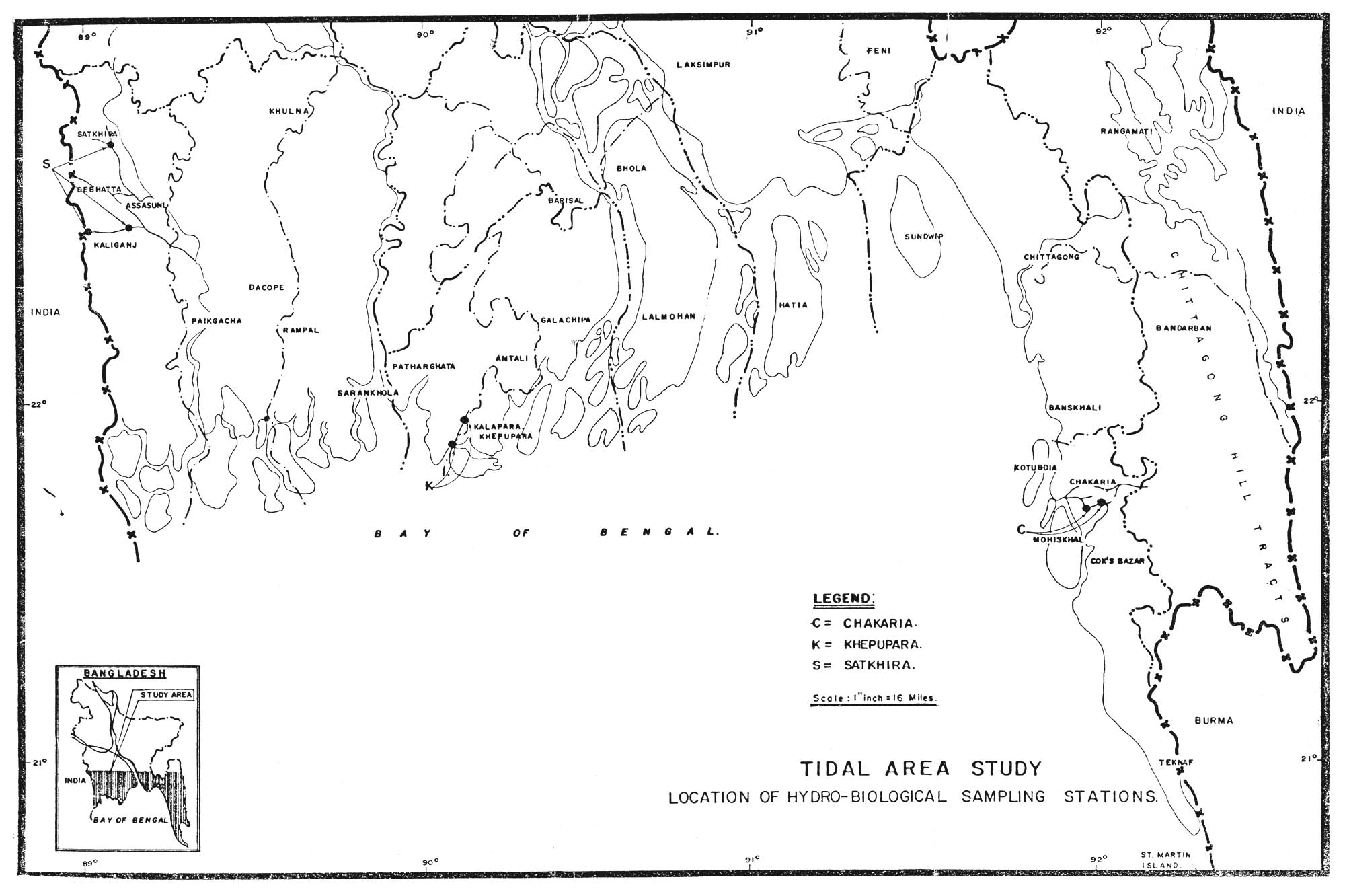
1.04 In order to supplement the existing data base, though to a limited extent, field observations regarding soil salinity of two predetermined spots within the tidal area were made. One such observation point is located in Satkhira subdivision of Khulna district and the other one is located in Chakaria Sundar bans of Chittagong district.
1.05 Contents of the Report
Included in this report are 5 sections as follows:
Section 1 presents the introductory statement on the format of the report, objectives and background of the study;
Section 2 contains information on general nature of the area;;
Section 3 presents a general assessment of the soils and land potentialities of the tidal area in general and the sample areas in particular;;
Section 4 summarises the results of field investigations carried out during October, 1982 to May 1983 in two locations; one in Polder 1 of Khulna district and the second one in Ilishchar area of Chakaria Sundarbans under Chittagong district;;
Section 5 presents an indicative interpretatum of soil analytical results and its interaction to agricultural potentialities.;
Section 6 discusses the effect of shrimp and other fish culture on agricultural potentialities of the Tidal Area
Location and Extent
2.01 Although the extent of tidal area is not well-defined but an indicative expanse of tidal area comprising the five coastal districts is presented below:
| Name of the District | Total Area in sq.miles | Tidal Area in sq.miles | Percent of Tidal Area | |
| 1. | Khulna | 4652 | 39281 | 84.44 |
| 2. | Barisal | 2060 | 1555 | 75.48 |
| 3. | Patuakhali | 1632 | 1632 | 100.00 |
| 4. | Noakhali | 1855 | 1150 | 61.99 |
| 5. | Chittagong | 2705 | 1580 | 58.41 |
| Total | 12904 | 9845 | 76.29 |
1 inclusive of Sundarban Forests which is about 2228 sq.miles.
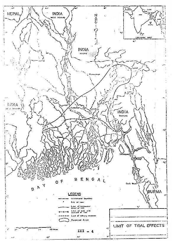
The tidal area (Exhibit 2.1) lies generally approximately below 24°30" North latitude covering about 9845 sq.miles which is about 76 percent of the total area of the five coastal districts.
2.02 Communication
The district headquarter towns as well as most of the subdivisional towns in the tidal area are either connected by Bangladesh Railway or road and/or riverine transport. The Upazillas within the area with the exception of Chittagong and Noakhali districts are connected by waterborne transport. Inter and intravillage communication within the area is dismal and watercraft both mechanised and non-mechanised are the only means of transport.
EXHIBIT 2.1
Climate
2.03 The area has pronounced tropical monsoon climate. There are three main seasons, the monsoon (or rainy) season from June to October which is warm and humid during which about 77 – 80 percent of the total annual rainfall occurs; the winter, from November to February, during which very little rainfall is received and has the lowest temperature and humidities of the year and the pre-monsoon (or hot) season from March to May, which has the highest temperature and evaporation rates of the year and has periodic thunder showers receiving about 15–20 inches of the total annual rainfall.
2.04 The cyclonic storms originating in the high seas during April-May and October-November associated with tidal wave surge affect severly the tidal area, when crops, livestocks, property and human lives are lost.
Geology and Physiography
2.05 The tidal area is underlain entirely by sedimentary deposits recent in age. The overall pattern is a large area of estuarine floodplain in the east and a large area of tidal floodplain in the southwest. A brief description of the different physiographic unit within the area is presented hereinafter.
2.06 Old Meghna Estuarine Floodplain
This comprises an almost level landscape, with little different in elevation between the broad ridges and basins, Flooding is shallow in the east, becoming deep towards the west, and is tidally influenced in the extreme south. The sediments are predominantly highly silty and finely stratified, with clays in some basins. The landscape differs markedly from those of both river and tidal floodplains. It is smoother and lacks the abandoned channels of river meander floodplains, and it lacks the frequent tidal creeks of a tidal floodplain. There are a few small rivers in the unit. Most of the drainage is provided by man made canal.
2.07 Yong Weghna Estuarine Floodplain
This occupies young, almost level, alluvial land within and adjoining the Meghna estuary. River erosion and new deposition are constantly in progress. The sediments are highly silty, finely stratified and slightly calcareous. They are also mainly slightly saline. Flooding is mainly shallow, fluctuating tidally, and is by rain water or sweet river water, except on the immediate coast and exceptionally at high spring tides and during cyclonic storm surges.
2.08 Ganges Tidal Floodplain
This area has a lower relief and crossed by innumerable tidal rivers and creeks. The sediments are mainly noncalcareous clays but they become more silty in the east and usually have a buried peat laver in the west. The rivers are saline throughout the year in most of Khulna district. In Patuakhali district, they are mainly fresh in the monsoon season, but become saline in the dry season. In the north of Patuakhali district and in Bakerganj (Barisal) district, they remain fresh throughout the year (except on the east coast of Bhola island). Seasonal flooding is mainly shallow and by fresh river water or rain water, except at high spring tides and during cyclonic storm surges in the extreme south and east.
2.09 Sundarbans
The Khulna Sundarbans are part of the Ganges tidal floodplain which as remained under mangrove forest. The area is affected by tidal salt water flooding for most or all of the year. The Chakaria Sundarbans occupy tidal flats at the mouth of the Matamuhuri river in Chittagong district.
2.10 Chittagong Coastal Plain
This includes the generally narrow strip of land between the Chittagong hills and the sea, together with the Halda, lower Karnaphuli and lower Sangu river floodplains, and the greater part of the off-shore islands. The unit consists of gently sloping, mainly loamy, alluvial flats adjoining the hills, and extensive level clay plains adjoining the three main rivers. Tidal clay plains occupy most of the off-shore islands in the south. Most of the area is subject to shallow flooding and to flash floods from the hills. It is also exposed to cyclones.
Vegetation and Land Use
2.11 The present land use in the area is mainly determined by the depth and duration of seasonal flooding, the availability of soil moisture in the dry season, the effect of salinity, the topography and also by the local agricultural practices. Depending on the depth of monsoon season flooding and the availability of dry season irrigation, rice can be grown in aus, aman and boro seasons. When the land is only shallowly flooded or water can be kept on the land by small bunds, farmers grow aus paddy followed by transplanted aman. If sufficient dry season soil moisture is available a second or a third dry land crops can be raised. In the moderately saline areas, a single crop of transplanted aman can be grown whereas, in saline and toxic soils only mangrove forests thrive.
2.12 The Sundarbans which is tidally flooded with saline or brackish water for most of the year are entirely under mangrove forests. The important trees in these forests are Sundri (Heriterra fomes), Gewa (Excoecaria agallocha), Goran (Ceripos roxburghiana), and Kesra (Sonneratia apetala). Other trees associated with this area are Dhundul (Caropa obovata), Amon (Amoora cucullata), Pasen (Caropa Moluccengis), Bain (Avicennia tomentosa), Kankra (Bruguiera gymnorlliza) etc.
2.13 Chakaria Sundarbans which is almost a level swamp crossed by many tidal creeks are tidally flooded with salt water, except where embanked and reclaimed. This area is under mangrove forest and the reclaimed land is mainly used for salt production in the dry season. The important vegetation are grasses (Oryza coarctata and Imperata cylindrica), Bain, Keora, Sundri, Gewa, Goran etc.
General
3.01 A general and indicative assessment of the soils and land potentialities of the tidal area is presented herein. The area has several hundred different kinds of soils. (Exhibit-3.1) As such different soil types described in this section include several different soils series which, although similar in general appearence and mode of formation may differ in one or more properties and in agricultural use and potentials. The individual soils are described in the reconnaissance Soil Survey Reports and anyone desireous of having detailed information on these may refer back to these reports.
3.02 Though soil types may include one or more soil series but these are generally occur in a well defined relationship to the landscape. Soil patterns may be complex or simple but there is usually a topographical relationship between deposition of varying ages. However, these groupings of different kinds of soils into a single type is non-technical but would provide essential information.
Soil and Land Potentialities
3.03 The soils of the tidal area have been broadly classified into three categories depending on parent materials, topographic situation etc. These are:
Exhibit - 3.1
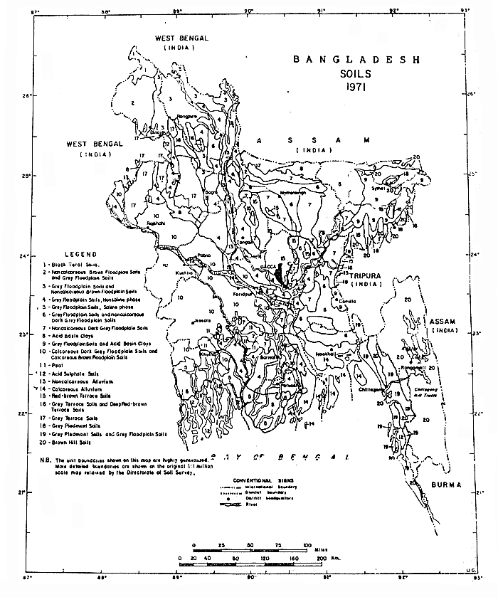
3.04 Grey Floodplain Soils
These include both non saline and saline soils and are developed in noncalcareous alluvium. They are mid-grey in the subsoil (especially on the surfaces of cracks and pores), and between medium acid and moderately alkaline in reaction. Alluvial stratification is broken or absent in the subsoil. These soils are shallowly to deeply flooded in the monsoon season, but mainly drain early in the dry season, except in some basin centres. They occupy middle Meghna and Ganges tidal floodplains, as well as important areas on the old Meghna estuarine floodplains, and on the Chittagong coastal plain.
3.05 The cultivated topsoil and ploughpan are grey, with strong yellow or brown stains along root channels and some cracks. The subsoil is usually 6–18 inches thick. It has an overall grey or brownish grey appearance, but in detail consists of a fine mixture of grey and brown (or yellow-brown) with continuous grey surfaces along pores and cracks. The substratum consists of stratified alluvium (or sometimes buried soils), and varies in colour from grey to black. In some soils it remains permanently wet; in others, the permanently saturated layer is at a depth of 5–8 feet.
3.06 The topsoil becomes near-neutral in reaction after continuous submergence for about two weeks, but mainly becomes medium to strongly acid on drying out. The subsoil and substratum are mainly neutral to mildly alkaline, but the subsoil of Chittagong coastal plain and some middle Meghna floodplain soils are slightly to medium acid. Soils in the south of the Ganges tidal floodplain and in the west of the Chittagong coastal plain are slightly to strongly saline in the dry season, but mainly monsaline in the topsoil in the monsoon season. Soils in the west of the Ganges tidal floodplain and on the Chittagong coastal plain often contain buried acid sulphate layers in the substratum which would become toxically acid if allowed to dry out.
3.07 Grey floodplain soils vary in texture with the relief. Topsoil texture is rather variable, but it is often light than the subsoil in ridge soils and of similar texture heavier than the subsoil in basin soils. Subsoil texture also varies with the relief, ridge soils generally being better textured than adjoining depression soils. The property between soils of different subsoil texture vary between plains, and locally within particular floodplains. In grey silty clays and clays predominate on the middle Meghna and Ganges tidal floodplains, and on the Chittagong coastal plains Where Grey Floodplain Soils occur on the old Meghna estuari floodplains, they mainly occupy ridges in association with noncalcareous dark grey floodplain soils in basins.
3.08 The Grey Floodplain Soils are amongst the most highly productive in the country. Crops and crop rotations are mainly determined by the depth and duration of monsoon season flooding and by moisture storage capacity in the dry season. Dry salinity limits crop production to the kharif season south of the Ganges tidal floodplain and on much of the on the Chittagong coastal plain.
3.09 Acid Sulphate Soils
Occupy the Khulna and Chakaria Sundarbans, and small are adjoining them. These soils resemble Grey flood plain soil in their wet state, but they become toxically acid (pH be 4.0) if allowed to dry out. Such soils that have dried out and become barren are called ‘kosh’ soils in Chittagong district.
3.10 These soils mainly occur under mangrove forest and are tidally flooded with salt water for most or all of the year. Some soils outside the forest are embanked and subject to freshwater flooding. The soils are mainly grey or dark grey and muddy on the surface, and contain variable amounts of undecomposed organic matter in forested areas. Where cleared for cultivation, they are mixed with red, brown and yellow colours in the subsoil, and may be salty on the surface in the dry season. These are very poor agricultural soils and should be left under forest wherever possible. Reclamation of such soils for agriculture is expensive.
3.11 Calcareous Alluvium
This unit includes land along the Ganges floodplain as well as in the Meghna estuary. These areas include:
3.12 The Ganges Floodplain includes charland and very young alluvial land along the main Ganges channel. The relief is mainly irrigular, and the land is liable to river erosion or burial by new alluvium each flood season. Flooding is mainly deep. The deposits are mainly silty, locally sandy. This land is variously used for aus, mixed aus and deepwater aman, or deepwater aman alone, often followed by mustard or other rabi crops. The potential for development is restricted by the hazards of river erosion, rapid flow of floodwater and/or burial by thick new alluvial deposits. Small scale irrigation could be used for cultivation of boro or improved dryland rabi crops in some parts.
3.13 The Yound Meghna Estuarine Floodplain has highly silty soils on almost level relief. Seasonal flooding is mainly shallow and tidally controlled, and is mainly by sweet water.
Most of the soils become slightly saline in the top soil by the end of the dry season. Transplanted aman is the major crop Aus and dryland rabi crops are grown in addition where the soils are not too saline. Agricultural potential is limited by the general lack of suitable irrigation sources; hazards of river erosion, cyclones and storms surges; salinity in the dry season; and slow subsoil permeability. Aman production could be increased by use of improved varieties and fertilizers. Improvement of aus and dry land rabi crops depends on reduction of dry season salinity. This depends on permanent protection being provided against saline storm surge flooding, together with cultivation and drainage measures being adopted to improve subsoil permeability.
Soils and Land Potentials of the Sample Area.
3.14 Satkhira Area (Ellarchar) The landscape consists of flat areas and numerous tidal channels and creeks criss-crossing the area. The sediments are mostly clayey and soils are saline. In some areas undecomposed organic matter or burial layer (peat or muck) occurs within the profile, the thickness of this layer is variable. These soils (Ellarchar series) are noncalcareous, dark grey to very dark grey, firm silty clay or caly with strong prismatic and blocky structure. Organic soils are also (Peat or muck) encountered in the area. The only cropping pattern is a single crop of transplanted aman. Recent years have seen shrimp culture where there is suitable hydrological situation.
3.15 Chakaria Sundarbans (Eillshia) The soil of tidal flats or ridges (Chakaria series) comprises tidally flooded, poorly to very poorly drained soils developed in the very young tidal sediments of the mangrove tidal floodplain. They have a mottled dark brown to dark yellowish brown, raw, silt loose silty clay loam subsoil. These are slightly to strongly saline. Regular tidal flooding, slight to strong salini potential toxicity, rawness of the sediments and risk of river erosion and burial by fresh tidal deposits are the factors which make these soils unsuitable for agricultural Under present situation these soils after being cleaned of mangrove forests are used for shrimp culture.
3.16 Soils of the shallow basins or inter ridge depression
comprises seasonally flooded, poorly drained, fine textured
soils developed in the tidal deposits of the mangrove
Objectives
4.01 The objectives of limited field investigations in the tidal area study is to supplement, where necessary, the available data in order to arrive at an indicative assessment of soils and land potentialities. This inter alia, helped in finding out the impact of the shrimp culture on the production of transplanted aman, the principal crop.
4.02 The terms of reference indicated that at least two tests will have to be carried out monthly from selected locations: One in Polder 1 of Satkhira and the other at Rampur area (Ilishchar) in Chakaria Sundarbans.
Methodology
4.03 Two observation points from each location were selected from where samples were collected by Dutch Auger. In the Satkhira area one of the locations was shrimp field (Pond) and the other was outside the pond. In Rampur area is Chakaria Sundarbans the first one was located in the tidal flats where as the second one was situated on the basins: outside the pond.
4.04 At the first instance a complete profile of soils were sampled to establish soil series. The basic objective of collection of complete profile is to corelate the soils of the observation points with the soil series identified by the Department of Soil Survey. In the second stage, samples were collected monthly for a period of 8 months, starting from October 1982 to May 1983 for determination of soilwater chlorinity. The samples were collected from the upper layer of 20 – 30 cm of each of the observation points.
4.05 Physical and chemical analyses of the complete profile of two observation points and subsoil water chlorinity of the upper layers of the samples collected monthly have been done and are presented in Tables 4.1 to 4.2.
Analytical Methods
4.06 Texture: After destruction of organic matter where necessary and dispersion by Calgon, texture was determined by the hydrometer method. The results generally are not corrected for organic matter percentage, which thus shows up as an excess in the sand fraction. Only where the carbon percentage exceeds 3 have textures been corrected. US sand (50 micron), International silt (20-2 micron) and clay (2 micron) are given.
4.07 pH. - Soil reaction was determined on a saturated soil paste using a Backman Zeromatic pH meter with glass electrode.
4.08 Conductivity (EC. 103). Electrical conductivity was determined using a Solu bridge. The results are expressed in mmhos/cm at 25°c.
4.09 Soluble Salts: A figure for total soluble salts was calculated from the conductivity data using an approximate average line adjusted for saturation percentage.
Table - 4.1
ANALYTICAL RESULTS OF THE SOIL SAMPLES
OF SATKHIRA AND CHAKARIA SUNDARBAN AREA
| Sl.No. | Location | Series Name | Depth (cm) | Mechanical Analysis | Textural Name | pH | EC value mmhos/cm at 25°C | Total soluble salts PPM | % Organic C | Total Nitrogen. | Sulphate me/100g | Free % CaCo3 | ||
| US % Sand | US % Silt | % Clay | ||||||||||||
| CS-1 | Eillshia Chakaria | CHAKARIA | 0–20 | 2.50 | 61.30 | 36.20 | Sicl | 6.0 | 12.0 | 7000 | 1.25 | 0.11 | 3.01 | - |
| CS-2 | Chakaria | 20–45 | 3.50 | 62.50 | 34.00 | Sicl | 5.2 | 13.0 | 7820 | 1.01 | 0.19 | 2.10 | - | |
| CS-3 | 45–85 | 5.00 | 57.80 | 37.20 | Sicl | 4.8 | 12.0 | 7000 | 1.06 | 0.11 | 4.78 | - | ||
| CS-4 | 85+ | 4.70 | 58.30 | 37.00 | Sicl | 4.0 | 14.0 | 8460 | - | - | 9.25 | - | ||
| CS-5 | Eillshia | CHARINGA | 0.18 | 2.10 | 57.00 | 40.90 | Sicl | 4.5 | 10.5 | 6150 | 1.75 | 0.15 | 4.21 | - |
| CS-6 | Chakaria | 18–43 | 3.00 | 55.00 | 42.00 | Sic | 4.1 | 11.2 | 6790 | 0.99 | 0.10 | 1.90 | - | |
| CS-7 | 43–70 | 3.50 | 55.00 | 41.50 | Sic | 4.0 | 12.5 | 7325 | 0.85 | 0.08 | 1.63 | - | ||
| CS-8 | 70–95 | 4.00 | 56.00 | 40.00 | Sic | 3.9 | 12.0 | 7000 | 1.01 | 0.10 | 2.10 | - | ||
| CS-9 | 95–112+ | 5.50 | 54.00 | 45.50 | Sic | 3.6 | 14.0 | 8460 | - | - | 1.75 | - | ||
| S-10 | Ellarchar Satkhira | ELARCHAR | 0–14 | 1.90 | 38.00 | 60.10 | C | 5.9 | 6.0 | 3600 | 2.50 | 9.21 | 4.50 | - |
| S-11 | 14–20 | 2.50 | 29.00 | 68.50 | C | 5.8 | 6.2 | 3750 | 3.10 | 0.24 | 3.80 | - | ||
| S-12 | 20–48 | 3.50 | 27.00 | 69.50 | C | 6.1 | 6.0 | 3690 | 2.85 | 0.25 | 2.90 | - | ||
| S-13 | 48–81 | 4.20 | 31.00 | 64.80 | C | 5.9 | 7.5 | 4420 | 1.75 | 0.14 | 2.10 | - | ||
| S-14 | 81–102 | 5.20 | 28.00 | 66.80 | C | 5.0 | 11.0 | 6600 | 1.50 | 0.15 | 2.01 | - | ||
| S-15 | 102+ | 10.20 | 19.00 | 70.80 | C | 5.1 | 13.0 | 7820 | 1.15 | 0.10 | 2.78 | - | ||
| S-16 | Ellarchar Satkhira | CLARCHAR | 0–18 | 1.00 | 38.80 | 69.20 | C | 6.1 | 4.2 | 2560 | 2.25 | 0.21 | 4.21 | - |
| S-17 | 18–26 | 2.20 | 35.00 | 62.80 | C | 5.9 | 5.1 | 3000 | 2.15 | 0.21 | 3.10 | - | ||
| S-18 | 26–42 | 4.80 | 30.00 | 65.20 | C | 5.8 | 7.2 | 4200 | 2.01 | 0.20 | 3.30 | - | ||
| S-19 | 42–75 | 4.90 | 34.00 | 61.10 | C | 6.0 | 12.0 | 7200 | 1.08 | 0.10 | 2.10 | - | ||
| S-20 | 75–98 | 7.50 | 35.00 | 57.50 | C | 5.2 | 14.0 | 8400 | 1.50 | 0.10 | 1.68 | - | ||
| S-21 | 98+ | 10.20 | 28.00 | 61.80 | C | 5.0 | 15.2 | 9000 | 0.98 | 0.09 | 1.95 | - | ||
Table - 4.2
ANALYTICAL RESULTS OF SUBSOIL WATER SAMPLES OF
SATKHIRA AND CHAKARIA SUNDARBANS COLLECTED
MONTHLY (FROM OCTOBER 1982 TO MAY 1983)
| Sl.No. | Location | Series Name | Depth (cm) | Month of Collection | EC. Value mmhos/cm at 25°C |
| CK-1 | Eillshia (Tidal flat) | Chakaria | 20–30 | Oct 1982 | 5.10 |
| CK-2 | " | " | Nov 1982 | 5.90 | |
| CK-3 | " | " | Dec 1982 | 6.50 | |
| CK-4 | " | " | Jan 1983 | 6.80 | |
| CK-5 | " | " | Feb 1983 | 7.20 | |
| CK-6 | " | " | Mar 1983 | 10.50 | |
| CK-7 | " | " | Apr 1983 | 15.20 | |
| CK-8 | " | " | May 1983 | 15.00 | |
| CH-1 | Eillshia (intersidge depressions) | " | " | Oct 1982 | 3.10 |
| CH-2 | " | " | Nov 1982 | 4.20 | |
| CH-3 | " | " | Dec 1982 | 4.85 | |
| CH-4 | " | " | Jan 1983 | 5.10 | |
| CH-5 | " | " | Feb 1983 | 5.95 | |
| CH-6 | " | " | Mar 1983 | 6.25 | |
| CH-7 | " | " | Apr 1983 | 10.20 | |
| CH-8 | " | " | May 1983 | 9.80 | |
| S-1 | Ellarchar Satkhira (Inside Pons) | Ellarchar | " | Oct 1982 | 4.20 |
| S-2 | " | " | Nov 1982 | 5.75 | |
| S-3 | Ellarchar Satkhira (inside pond) | Ellarchar | 20–30 | Dec 1982 | 6.10 |
| S-4 | " | " | Jan 1983 | 8.20 | |
| S-5 | " | " | Feb 1983 | 11.50 | |
| S-6 | " | " | Mar 1983 | 14.20 | |
| S-7 | " | " | Apr 1983 | 16.25 | |
| S-8 | " | " | May 1983 | 19.50 | |
| S-9 | Ellarchar Satkhira (outside pond) | " | " | Oct 1 | |
| S-10 | " | " | Nov 1982 | ||
| S-11 | " | " | Dec 1982 | ||
| S-12 | " | " | Jan 1983 | 5.8 | |
| S-13 | " | " | Feb 1983 | 6.25 | |
| S-14 | " | " | Mar 1983 | 12.60 | |
| S-15 | " | " | Apr 1983 | 14.40 | |
| S-16 | " | " | May 1983 | 14.90 |
4.10 Sulphate: SO4 was determined by precipitation with BaCl2 as Ba SO4.
4.11 Organic Carbon: The carbon percentage was determined by the Walkey Black method, the result being multiplied by 1.33 to arrive at a total carbon figure assuming 75% efficiency.
4.12 Nitrogen: Total nitrogen was determined by the semi micro kjeldahl method using a selenium/copper catalyst.
4.13 Calcium Carbonate: The calcium carbonate equivalent was obtained by the rapid titration method.
Observations
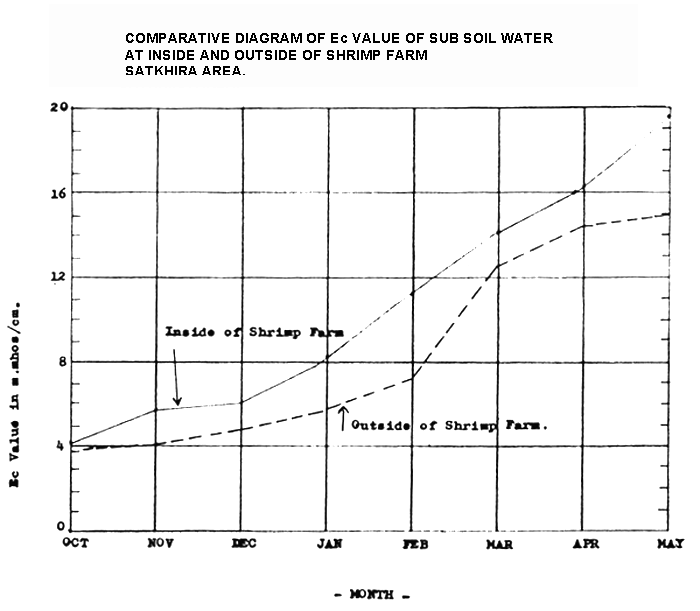
4.14 Sub-soil water chlorinity: Sub-soil water chlorinity data for both the observation pond were plotted in a graph and presented in Exhibit-4.1 and 4.2. As may be observed from the Exhibits the Electrical conductivity in mmhos/cm at 25°C tend to rise in February and there is little difference of salinity between inside and outside the pond.
EXHIBIT-4.1
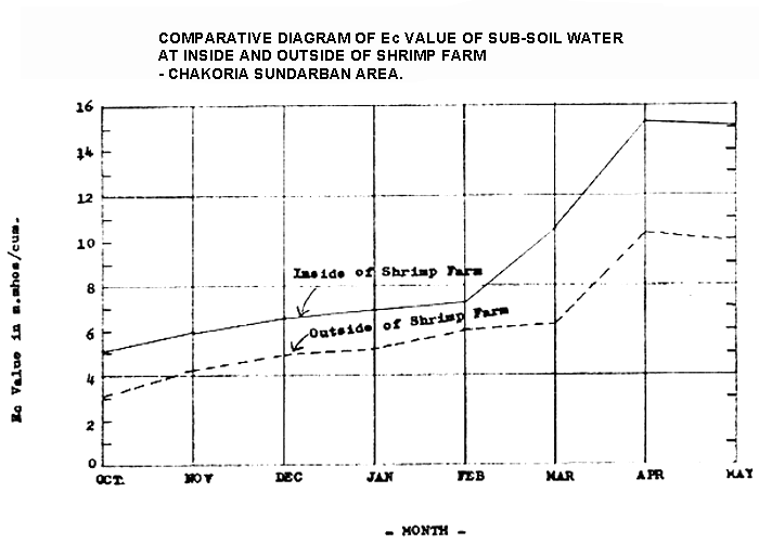
EXHIBIT - 4.2
5.01 General: Ref. Table 4.1 and indicative interpretation of analytical results of soils collected from two sample areas has been made. Interpretation has generally been guided by (i) Physical properties, (ii) Salinity and (iii) Nutrient responsiveness of the soils analysed.
5.02 Physical properties
Physical properties of soils are one of the important factors for crop production and soil management. Since most of the physical properties like soil texture, soil depth, water holding capacity permeability etc. can not be changed easily, management and crop production have to be adopted to them. For efficient crop production tillage has to be considered. Tillage is turning, loosening, cultivating and compacting of soils. Tillage also controls weeds, mixes crop remains with the soils, makes better aeration and helps to absorb more rainwater.
5.03 The soils of Ellarchar, Satkhira is fine textured (clay) and have a more or less well developed structure. These soils can be worked with country ploughs within a very narrow range of optimal moistive conditions for paddy cultivation. The use of light traditional ploughs lead to formation of hard clods. This is aggravated by the distruction of soil structure by§ puddling of the soils for transplanted aman cultivation.
5.04 The soils of Ellisha in Rampur area is medium to moderately. The textured and pose no constraints on tillage or any other physical characteristics.
5.05 Moreover, repearted cultivation and puddling over the years, ploughpans have developed below the cultivation layers. This ploughpan though necessary for transplanted rice cultivation, nevertheless, it interferes root development as well as downward movement of rain and irrigation water.
5.06 Salinity. The soils are moderately to strongly saline, though the degree of salinity is very variable locally. The salts have apparently been derived mainly from regular tidal flooding by saline water. The presence of salt prevents rabi and aus crops from being grown. Heavy monsoon rainfall reduces the topsoils salinity sufficiently for transplanted aman to be grown, but yields area very often reduced especially in the years with low rainfall.
5.07 During the dryseason capillary movement of moisture to the soil surface concentrates salt in a thin layer at the surface where this localized concentration may be sufficient to limit crop production untill there has been sufficient monsoon rainfall to dilute or leach the salt. However, the salt is only slowly removed because of the slow permeability of the sediments and the apparent strong upward capillary movement of dilute salt solutions from the permanently saturated zone in each dry season.
5.08 Leaching of the soils by monsoon rainfall is unlikely to lead to soil fertility for permeability problems. The acid sulphate soils would be expensive to reclaim for agriculture, because of the problem of toxic acidity, if drained.
5.09 Soil Fertility.
Soil fertility is the ability to provide a favourable environment and balanced nutrient supply for optimum plan growth. Whereas natural soil fertility is the ability of the soil to provide an adequate plant nutrient supply from its own resources. The natural fertility of the soils (Satkhira) is high and well sustained. These natural fertility appears to be mainly maintained by the continuous supply of nutrients from the readily weatheras Environmental conditions such as high temperature wetting and drying and the fine size of the weat minerals are favourable conditions for the release nutrients.
5.10 High acidity linked with sodium salt make the soil the Rampur area toxic and consequently of little agriculture use.
General
6.01 This section presents a very general assessment of the effect of mainly shrimp culture on rice production. This assessment is based (i) predominantly on field visits to the tidal area mainly in Satkhira area, Polder 20 in Khulna area Badarkhali-Rampur in Chakaria Sundarbans, Moiscal and Polder 66 in Cox's Bazar area and (ii) field investigations of a very small magnitude and also for a limited purpose in two locations; one in Satkhira area and the other in Chakaria Sundarbans. The observations and conclusions drawn here are therefore, very indicative in nature.
6.02 Effect on Rice Cultivation
The general argument is that the cultivation of shrimps in rice field decreases yield of rice. The decrease in yield of rice (transplanted aman) is caused by one or combination of reasons which primarily include; salinity of water taken in for shrimp culture, delayed transplanting of rice due to prolonged shrimp catching season and difficult field drainage before transplanting of rice. Shrimp culture in the rice field also negates the very objective of putting embankments against salt water intrusion.
6.03 Based on a very limited field investigation and that to for a very brief timescale, it is really difficult to put forward technical judgement either for and/or against the present controversy over the issue. The analytical results (Ref.Table 4.2 and Exhibits 4.1 & 4.2) indicate that there is not much significant variation in salinity in between the shrimp pond and outside.
6.04 Generally speaking, during the field trips and informal discussions with rice farmers and shrimp cultivators two things surfaced. In Khulna area specially in Polder 22, 20 and its vicinity there seems to be little or no effect on yield of rice cultivated in shrimp pond and outside. This year (1983 aman season) in these polders the Consultant has seen a reasonably good harvest and the farmers who are shrimp cultivators themselves also have no complaint. It has also transpired that even in year with less than adequate rainfall these areas produce reasonably good harvest. One of the explanations is that the areas receive upstream flows of sweetwater during and after the transplanting period cuasing little or no salinity in the area.
6.05 In Satkhira area, the problem is a bit different from Khulna. Satkhira receives practically no upstream flow of sweetwater and primarily depends on the its own catchment flow of sweetwater. In years with less than average rainfall the farmers experience increased salinity during the flowering stage of (October) the transplanted aman which provides a burnt out look and severly dwindled rice yield. However, in 1983 with more than normal rainfall rice harvest reached normal level. In years before this, rice harvest was poor to very poor.
6.06 Continuous inundation for shrimp culture causes shrink of available area for grazing which in turn decreases the livestock population. Fall in the livestock population created shortage of draft animal for agricultural production and protein.
6.07 Sedimentation:
Sedimentation though not a pronounced problem now may become one in the near future. Interviews with the local population have revealed that during the last decade there has been a steady builtup of areas outside the polders. In one instance (Polder 1) it has been pointed out that least 2–3 metres have been builtup making it difficult to take in tidal water for shrimp culture. Sedimentation would definitely create problems for shrimp culture. In Chakaria Sundarbans which have been cleared very recently there has been no perceptible evidence of large scale sedimentation.
6.08 Ecological Problems
In areas where shrimp culture is practised now there has become a steady decrease of freshwater resources due to prolonged salination of ponds and khals. This has reduced the sources of drinking water for people and animals.
6.09 Increasing number of complaints have been voiced by the population of the area that due to high salinity large number of fruit trees have perished; through the assertion is largely unsubstantiated. Large scale deforestation of mangrove forests in Chakaria Sundarbans may create conditions unsuitable for planktons habitat resulting in reduced shrimp yield.
6.10 Concluding Observations
Under average rainfall conditions shrimp culture does not seem to have any damaging effect on rice cultivation since rain and fresh riverwater prevent accumulation of salt. But with less than normal rainfall and specially when the soil surface is exposed accumulation of salt by capillary rise in the top layer is generally observed resulting in reduced crop yield.
6.11 Shrimps are profit earning crop and compete favourably with rice and at the same time shrimps are not replacing multiple cropping. Shrimp lands are single cropped area and can not be brought under irrigation because of salinity in the river. Shrimp culture is limited to a very small area compared to total cultivated area of the country and may, therefore, have not even a rippling effect on the total production of the country.
6.12 The conclusions drawn here are based exclusively on field visits and a very limited field investigations which can not provide adequate data base. There is compelling need for empirical work done over a period of time with sustained field investigations and monitoring so that the controversy can be dispelled by way of sound and scientific references.
REFERENCES
| 1. | Department of Soil Survey Ministry of Agriculture, Government of Bangladesh. | Reconnaissance Soil Survey-Noakhali district and Sadar North, Sadar South and Chandpur Subdivision of Comilla District, 1970. |
| 2. | Department of Soil Survey Ministry of Agriculture, Government of Bangladesh. | Reconnaissance Soil Survey, Sadar North Subdivision of Chittagong District, 1971–72. |
| 3. | Department of Soil Survey Ministry of Agriculture, Government of Bangladesh. | Reconnaissance Soil Survey Sadar South and Cox's Bazar Subdivision, Chittagong District, 1976. |
| 4. | Department of Soil Survey Ministry of Agriculture, Government of Bangladesh. | Reconnaissance Soil Survey Sadar and Bagerhat Subdivision Khulna District, 1977. |
| 5. | Department of Soil Survey, Ministry of Agriculture, Government of Bangladesh. | Reconnaissance Soil Survey, Satkhira Subdivision of Khulna District, 1975. |
| 6. | Department of Soil Survey Ministry of Agriculture Government of Bangladesh. | Reconnaissance Soil Survey, Barisal District, 1968. |
| 7. | Food and Agriculture Organisation of the United Nations. | Soil Survey Project - Banglad - Agricultural Development possibilities AGL: SF/PAK 6, Technical Report No.2, Rome, 1971. |
| 8. | Rashid, H., | The Geography of Bangladesh, Unwin Press Ltd., Dhaka, 1977. |
| 9. | Smith, W.G., | The Tidal Area Study, An Interim Report. FAO/UNDP Fisheries Resources Survey System, Dhaka. |
![]()
![]()
![]()