![]()
![]()
![]()
(07) The background to site and design requirements has been provided by the two previous reports (Reports 5 and 11) and has briefly been covered in phase 1 of this study (Report 3). Tables 3 and 4 summarize the critical aspects.
Table 3 - General site and design requirements
| - Adequate size for the facilities required; |
| - In one of the main production areas for Penaeus shrimp; |
| - Easily reachable by road, near main city services; |
| - Adjacent to good quality settlements; |
| - Suitable land elevation for 0.1 to 0.5 m of tidal depth, drainable at low tide; |
| - At least 4–5 months salinity of 10–25 ppt for Penaeus growth, and with times suitable for Macrobrachium growth (10–12 ppt); |
| - Suitable soils for wall construction and water retention; |
| - Suitable soil pH (6.5–8.5) for good survival and growth of stock; |
| - Including a range of soil types representative of the region; |
| - River or canal for water supply remaining deep and active for at least 10 years, with no pollution risk; |
| - Availability of good source of fresh water near the site; |
| - Potential for low cost site development (e.g. within a polder, with no heavy vegetation and root cover); |
| - Sufficient raised land area to permit building construction without land filling and compacting. |
Table 4 - Site and design requirements: physical facilities
| - Three (3) 1.0 ha ponds; |
| - Nine (9) 0.5 ha ponds; |
| - Eighteen (18) 0.2 ha ponds; |
| - Twenty-seven (27) 0.1 ha ponds; |
| - Water storage/reservoir ponds; |
| - Laboratories for biology, chemistry, wet laboratory; |
| - Store-room, fume chamber; |
| - Shed for outdoor tank work; |
| - Area for small-scale hatchery development; |
| - Area for farm design experiments; |
| - Jetty and small store; |
| - Administrative and residential accomodation. |
(08) A comprehensive evaluation of available sites has identified an area approx. 3 km northwest of Paikgacha township, in the Khulna District, on the lower Sibsa river, as possessing the most favourable characteristics. Its relative scoring is shown in Table 5 (North Shiberbati (NS) site).
Table 5 - Relative scoring of selected sites for BFRS
| SITE | SCORING | NOTES |
| Rampal R&H | 185 | Poor services, fresh water; |
| Rampal Town | 211 | Expensive to develop; |
| Digraj (Mongla) | 127* | Services limited; |
| Munshiganj | 186* | Poor services, access; |
| Kaliganj | 231 | Good, more distant to upazila; |
| Benerpota | 133* | Land may not be available; |
| Paikgacha SS | 225 | Good, soil less representative; |
| Paikgacha B | 236 | Good, soil less representative; |
| Paikgacha NS | 273 | SELECTED. |
| * Not completely evaluated: rejected earlier during assessment. | ||
Figures 1 and 2 show the general location of the site area, which is adjacent to the present Department of Fisheries Fish Seed Multiplication Centre.
(09) The particular qualities of the proposed area are summarized in Tables 6 and 7. General data on climatic conditions are provided in Table 8.
Relative site and tidal levels are shown in Figure 3, in their relation to pond development.
Details of a preliminary topographical survey, conducted during the site survey are shown in Figure 4. Figure 5 shows the initially surveyed soil characteristics. Further details are provided in Annex C.
Table 6 - Paikgacha site: general characteristics
| INFRASTRUCTURE | |
| - 150 m from metalled road; | |
| - Launch available; | |
| - 120 min. from Khulna (65 km), 135 min. from Jessore (83 km), 105 min. from Satkhira (58 km); | |
| - Adjacent to upazila headquarters; | |
| - Power, fuel, phone available; | |
| - Fresh groundwater available. | |
| PHYSICAL DETAILS | |
| - Land elevation 1.0 m; | |
| - Max. inundation 1.7 to 2.2 m (1.8 m), May - September; | |
| 1.25 to 1.4 m (1.3 m), December - February; | |
| - > 10 ppt salinity for 4 months, 5 – 8 ppt for 3 months, 14 – 26 ppt for 2 – 3 months; | |
| - Clay, silicate clay soils, with thin peat layer in some areas, some acidity. | |
Table 7 - Advantages and disadvantages of the Paikgacha site
| ADVANTAGES |
| - Best combination of soil types characteristic of Khulna area; |
| - Existence of areas of ‘problem soils’ typical of those in shrimp areas; |
| - Predominant soil is most common type in Khulna floodplain area; |
| - Tidal inundation of at least 60 cm available year-round; |
| - Creeks within site may be used for drainage; |
| - Situated within WDB polder; |
| - Near World Bank shrimp culture project, polder 20, possibilities for linkage; |
| - Paikgacha centrally located within Khulna; |
| - Good facilities in Paikgacha. |
| DISADVANTAGES |
| - Surplus land may be required; |
| - Final stages of metalled road not yet completed; |
| - Possible problems with saline water control and adjacent farmers; |
| - River loops near area - possible risk of shoaling; |
| - Soil variations may make replications difficult; |
| - May need borrow-pits outside usable site area. |
Table 8 - Summary of climatic data
| JAN | FEB | MAR | APR | MAY | JUN | JUL | AUG | SEP | OCT | NOV | DEC | |
| Rainfall, Paikgacha, 1981 – 86, mm | ||||||||||||
| - minimum | 0 | 0 | 0 | 18 | 70 | 15 | 91 | 215 | 70 | 3 | 0 | 0 |
| - maximum | 27 | 22 | 32 | 213 | 282 | 759 | 362 | 475 | 253 | 165 | 8 | 93 |
| Temperature, 'C, Khulna | ||||||||||||
| - max.ave. | 26 | 29 | 33 | 35 | 34 | 33 | 31 | 31 | 32 | 31 | 29 | 27 |
| - min.ave. | 14 | 16 | 21 | 24 | 26 | 26 | 26 | 26 | 26 | 24 | 19 | 15 |
| Relative humidity, Khulna, % | ||||||||||||
| - 09.00 hr | 73 | 71 | 73 | 76 | 78 | 83 | 86 | 85 | 83 | 78 | 62 | 72 |
| - 18.00 hr | 62 | 55 | 55 | 65 | 74 | 82 | 84 | 84 | 83 | 78 | 69 | 67 |
| Ave.wind velocity, Khulna, km/hr | ||||||||||||
| 3.0 | 3.9 | 5.8 | 7.8 | 8.9 | 7.4 | 7.8 | 6.9 | 5.6 | 3.9 | 3.2 | 3.0 | |
| Mean monthly evaporation, Satkhira, mm | ||||||||||||
| 70 | 89 | 121 | 136 | 144 | 126 | 109 | 102 | 101 | 93 | 84 | 74 | |
(10) The main geographical and physical features of the area to be considered in the development of the design are:
- site levels are generally at approximately 0.9 – 1.0 metre above PWD datum (0.00 is approximately mean tide level);
- tidal range is in excess of 2 m during spring tides, approximately 1 m during neap tides;
- a Water Development Board Standard embankment protects the outer edge of the area; river/tidal levels are on average at or above the overall land area. There are several unofficial breaches of the dike in adition to the designed sluices; one of these lies to be north of the area;
- the site area, presently (October 1986) under aman rice cultivation is subject to regular inundation; there is at present no means of separating the site from the surrounding areas;
- there is a large khal, or channel at the northern side of the site. This is approximately at 0.000 m on PWD datum. An ill-defined network of smaller canals drains from the south into this (see Figure 2). Use of this channel for site drainage may cause problems however (see later);
- there is a slight site gradient to the south/southwest in the area south of the khal: this does not however impose significant constraints on the method of development;
- a small dike with access track lies to the north of the khal. This separates the site to some extent, but does not control inundation or drainage, as there are several culverts through the dike;
- the area around the Fish Seed Centre appears to provide a good access route to the site. Services (power, phone, etc) are available from here. There is no good quality access to the site at present, however;
- there are several settlements nearby the area; site security, particularly in the laboratory and smaller research pond areas may be critical.
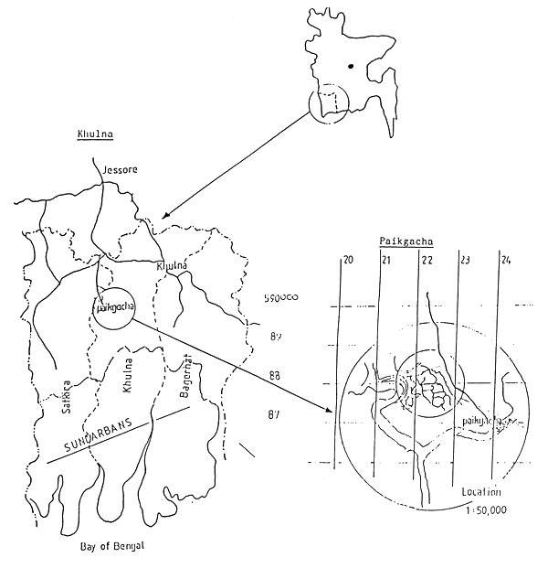
Figure 1 - General location of the site for BFRS.
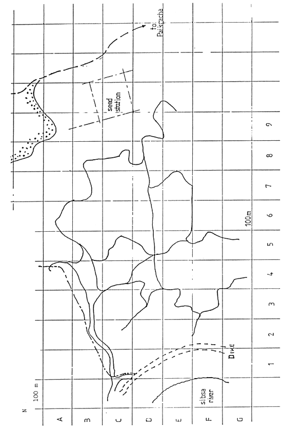
Figure 2 - Paikgacha (North Shiberbati) site
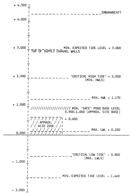
Figure 3 - Site and tidal levels.
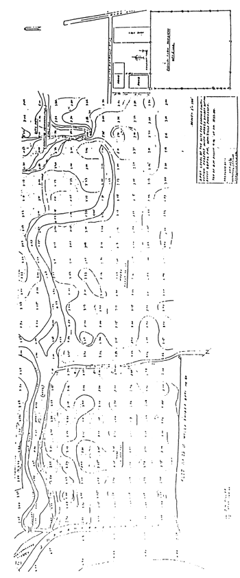
Figure 4 - Topographical details of Paikgacha site (Source: M. Karim)
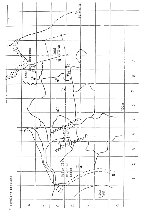
Figure 5 - Soil zones Paikgacha site (Source: M. Karim)
(11) Soils are generally of clay or silty clay, with some variation through the site, According to the site selection survey, a range of non-acidic soils of calcareous and non-calcareous types, soils with organic layers and acidic (though not acid sulphate) soils are present. In general the Barisal-Pirojpur (B-P) type soil association occurring on the site represents the highest percentage (24.8%) of the Khulna region flood plain soils, and thus gives the site some advantages in its relevance to regional shrimp culture conditions.
(12) The areas of acid soil are not expected to cause significant constraint to the layout of the site. Initial surveys suggest a limited area, at a depth of 60 – 90 cm below current site level with a thickness of some 30 cm. (Figure 6). In the case of a true acid sulphate soil, it would be advised not to disturb the top soil within 50 – 60 cm of this layer, but this precaution is not likely to be necessary. Initial descriptions of the soil suggest that the acidity could be leached or neutralized by conventional means if needed.
(13) Of more significance is the presence of a narrow (approximately 2.5 – 5 cm) band of organic peat in some cores. If this lies in regions where building is considered, expensive modifications to foundations may be required to protect against differential settlement.
This does not occur throughout, however, and is apparently not present in the slightly higher ground to the NE of the area, which in fact may have sand fractions in the soil, and may be most suitable for building.
(14) Environmental conditions in the site appear generally typical of those in the region. Salinities are relatively high during the dry season (Figure 7), yet reduce to nearly fresh water during the wet season (see Report 11, Annex D). There is thus the opportunity to work in the range of environments typical of the brackishwater region, and to provide for some degree of storage of water of specific salinities. The presence of a saline wedge on the site has not been determined; should it be present, an opportunity may be available for the selection of varying salinities of water at varying water depths within the river. This has not been assumed in the development of the design, however.
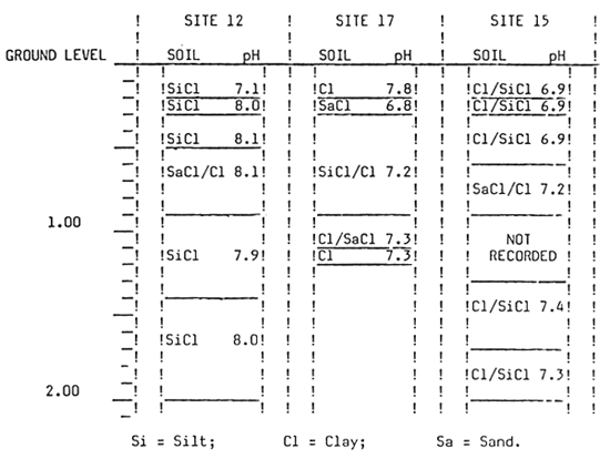
Figure 6 - Soil profiles Paikgacha (Source: M. Karim)
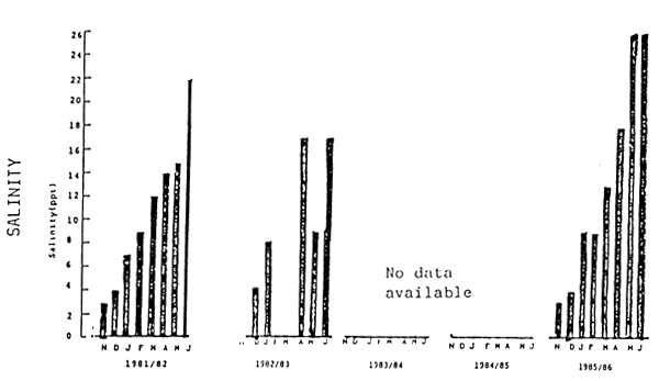
Figure 7 - Salinity at Paikgacha site (Source: M. Karim)
(15) Within the site area, a specific location must be selected to provide the best conditions for effective development of the project's requirements, without using excessive land area. The site will be naturally bounded on the west by the WDB perimeter dike; it will also be desirable to control all of the water area of the site. Thus another natural boundary is the smaller dike and road to the north, though the area nearest to the village may not be useful because of security problems. On the eastern side the existing fish seed station and the high land near it provides a natural boundary, while the position of the southern boundary, which will require a separating wall, could be determined by the pond and water supply area requirements. As an approximate target, an area of some 20 – 25 hectares would be allocated; the final area used will depend on final design and on budget resources. Figure 8 shows the overall site area as defined, and identifies particular problems.
(16) Table 9 lists the critical physical requirements of the design; Table 10 defines the theoretical area requirements. As the site is relatively low-lying, additional area may be required to provide fill material. If at all possible, it will be desirable to use existing channels to provide supply or drainage, both to minimize earth movement, and to reduce problems of ‘piping’, seepage, in areas where walls are made to cross former channel areas.
Table 9 - Critical physical requirements of the design
| - Main site walls and building volumes equalized wherever possible; |
| - Soil transport distances minimized; |
| - Borrow pits at least 2 m, preferably 5 m from dike base; |
| - Main site walls and building foundation base levels at least 0.3 m above maximum expected storm surge or flood level; |
| - Maximize area served per outer wall length, and per sluice gate system; |
| - Provide separate inflow and drainage to pond areas if possible; |
| - Provide simplest possible site access, with main walls strengthened sufficiently for vehicles; |
| - Provide for storage of fresh water and salt water; |
| - Provide full water supply and drainage control within the area, no undesirable effects on adjacent areas; |
| - Retain fringe vegetation where present. Protect exposed areas with planting, wood or cobble; |
| - Provide settling zone if possible, to avoid excessive siltation in ponds. |
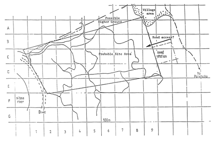
Figure 8 - Outline area for development
Table 10 - Theoretical area needed for BFRS
| Component | Dimensions | Total |
| 1 ha ponds | 3 × 10,000 | 30,000 m2 |
| 0.5 " " | 9 × 5,000 | 45,000 |
| 0.2 " " | 18 × 2,000 | 36,000 |
| 0.1 " " | 27 × 1,000 | 27,000 |
| Other pond areas | variable | 25,000 |
| Channels, walls | allow 10 % | 16,300 |
| Building area | variable | 10,000 |
| Total | 189,300 m2 | |
| This is 18.9 ha = 46,75 acres | ||
(17) Pond configurations should ideally be 2:1 to 3:1 lenght:breadth ratio. In strong wind areas alignment should be so that the shortest distances lie in the prevailing wind direction (i.e. ponds are at 90' to prevailing wind), to minimize erosion. In calmer areas, alignment should be with the prevailing wind, to maximize the opportunity for wind mixing of the water body. In most cases it is preferable for wind to blow towards the drain outlet area, as this permits convenient drainage of surplus detritus. If a good water supply is available, the reverse may be advantageous, as material blown up to the inlets may be redispersed by new water. In intermediate conditions, alignment does not become so critical. In this case, prevailing winds are from the south between April and October and from the northwest from November to February, generally of moderate strength (<30 km/hr). Cyclonic storms, occurring during the wet season from June-November, are significantly stronger (more than 100 km/hr at times). Alignment is therefore not particularly critical in these circumstances, but sufficient freeboard allowance should be made for wave action from any direction during storm conditions.
(18) The groups of ponds should be kept together as much as possible, forming a regular pattern, reducing to the minimum any variability likely to influence the proposed replicate trials specified for the BFRS research programme (Report 5). Ideally, water supply should be common to each group of ponds. This is generally less critical for the large ponds, which are of lesser number and possessing more inherent variability, than for the smaller ponds. As the soils are not evenly distributed across the site it may be difficult to provide for a ‘built-in’ range of soil conditions. In general, ponds of a similar group should be approximately the same distance from the work area, to eliminate bias; if not, the nearest ponds tend to get more attention. For similar reasons, it is preferable for the smaller ponds, which are likely to be more actively used and managed, to be nearer to the work centre. If possible the additional (reserve) areas should also be near the work centre.
(19) Ideally, the pond system should be serviced by separate supply and drainage canals. Here the khal provides a natural drainage; a supply canal would therefore need to be located at the other side of the site. If it is not possible to provide for this, the khal would combine both functions. If possible, provision could also be made for the option of pumping water, to increase flexibility of use of the site area.
(20) The site buildings should preferably be grouped together; Table 11 indentifies the outline areas involved. Residential buildings are commonly of 2–3 storey form, while laboratory and the higher grade residential units are single storey. Thus the former will be more critically dependant on soil bearing capacity. If possible, provision should be made nearby for field water, fresh water, and drainage services and access, and utilities should be easily available.
Table 11 - Outline areas for the site buildings
| Basic | Total | Plus acces | As per pp | Plus acces | ||||
| 1) Administration | (1) | 338m2 | 338 | 600 | 752 | 1000 | ||
| 2) Laboratories | (4) | 300 | 1200 | 2000 | 1012 | 1800 | ||
| 3) Services | (1) | 300 | 300 | 500 | 300 | 500 | ||
| 4) Accomodation: | ||||||||
B-grade | (2) | 150 | 300 | 500 | (2) | 300 | 500 | - 1 floor |
C-grade | (4) | 125 | 250 | 400 | (6) | 250 | 400 | - 2/3 floor |
D-grade | (8) | 100 | 300 | 500 | (12) | 400 | 600 | - 2/3 floor |
E-grade | (4) | 80 | 80 | 150 | (5) | 160 | 300 | - 3 floor |
F-grade | (8) | 60 | 180 | 350 | (31) | 600 | 1000 | - 3 floor |
G-grade | (4) | 50 | 50 | 100 | (10) | 150 | 300 | - 3 floor* |
| 5) Guesthouse | (1) | 300 | 300 | 500 | (1) | 300 | 500 | |
| * Assume some units built with other grades | ||||||||
(21) Of a number of different options, the layout shown in Figure 9 is proposed. This provides for most of the requirements described. Annexes D - F detail the main design approach. The layout has disadvantages in that ponds are not completely grouped into sets of three, which might simplify arrangements, but does provide for separate water supply for each pond size group. The main supply channel is relatively long, but this is inevitable on a site of this shape and form. All of the ponds are aligned in the same direction; approximately on the 80' – 260' axis, and have separate supply and drainage. As laid out, the site does not use minor channels significantly. However, the difficulties of aligning the ponds to suit the channel positions rule this out as a practical possibility.
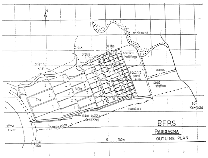
Figure 9 - Outline site development
(22) The building area is at the northeast corner of the site, where land is generally higher. Road access is suggested from the north of the existing seed centre, turning northwards towards the building area, southwards to the south wall, where access is provided to the site and the WDB dike. If soil conditions are unsuitable, land in the fisheries seed centre may be considered for residential buildings. The area south east of the building zone is to be set aside for further development.
(23) If fill material is required for the site, this may be obtained from the river sediments, which are suitable for use, on the outside of the main WDB dike, as well as from areas to the south of the south wall.
![]()
![]()
![]()