![]()
![]()
![]()
(24) Table 12 shows the main site boundaries and the requirements for separation of the site from the adjoining areas. The largest of these structures is the wall at the south of the site, which will carry a track suitable for vehicular access. The use of this side of the site is preferable as it is nearer to the main site and it is more easy to cross to the pond areas, though the total volume of material required may be larger, as part of the northern boundary would already be available in the from of the existing track. The main southern wall will however also form the southern side of the main supply channel (see Figure 10).
Table 12 - Development of site boundaries
| Eastern edge | - | Adjacent to fisheries seed station, needs short boundary wall/fence to south; area north of station will be occupied by buildings. |
| Northern edge | - | Small earth dike to separate station area from rice fields at eastern end. Western end uses track. |
| Western edge | - | WDB main embankment. |
| Southern edge | - | New wall, with roadway, approximately 2–2.5m above grade. Also acts as outer wall for main supply channel |
(25) A certain amount of fill material may be required around the building area; a nominal quantity of 1 m (1 m3 per m2 area) is allowed for this. There are few other significant site development needs and much of the site material may be obtained directly on location. Overall site levels are defined in Figure 11; as can be seen this allows for good filling and draining in most tidal cycles, but requires some water control during heavy flood tides.
(26) The main pond areas are defined in the earlier reports: 3 × 1.0 ha, 18 × 0.2 ha, and 27 × 0.1 ha. Using the guideline of 2–3:1 for L:B ratio, the following nominal dimensions are found to suit the site layout (Table 13).
Water depths are set at a minimum operating level of 1 metre; with sufficient freeboard allowed for access and freedom from overtopping through wave action: 0.3 m is allowed for the large (1.0 and 0.5 ha) ponds, 0.2 m for the smaller ponds. Nominal water fill volume is therefore 138,000 m3 at 1 metre depth.
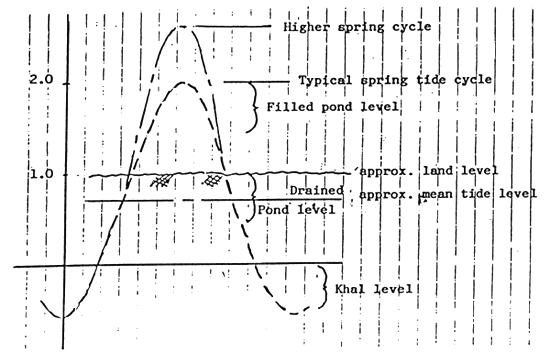
Figure 10 - Tidal cycles and pond depths
Table 13 - Nominal pond dimensions
| POND TYPE | DIMENSIONS |
| 1.0 ha | 165 × 60 m |
| 0.5 ha | 125 × 40 m |
| 0.2 ha | 65 × 30 m |
| 0.1 ha | 50 × 20 m |
Table 14 - Typical wall top widths
| AREA | TOP WIDTH | NOTES |
| Supply channel, 1.0ha, 0.5ha ponds | 1.0 m | Personnel, small carts, etc. Can be wider for vehicles. |
| 0.2ha, 0.1ha ponds | 0.5 m | Personnel. Can be reduced to 0.3 m in smaller ponds. |
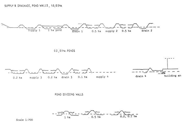
Figure 11 - Pond wall and drainage cross sections
(27) Ideally pond walls should slope at levels corresponding with the natural angle of repose for the soil material, which in this case (clay, silt/clay) would correspond to 2–3 on 1. In practice, to reduce wall volume, steep walls are used, at the expense of greater periodic maintenance, which would not be expected to be significant. Thus a nominal 1:1 slope is used. Wall widths between ponds are shown in Table 14; these allow for routine operation, but do not permit vehicular access. Figure 11 shows the typical wall cross-sections. End walls, which form the supply and drainage channels are described in the pond sections.
(28) Each pond is configured to allow water in from the supply canal at the centre of one end, to drain from the centre of the opposite end. A nominal gradient of 0.1 % (1 metre in 1000 metres) is preferable, but in practice, a slight slope around the drainage point is normally sufficient, provided there are no deep depressions in the pond floor.
(29) There is additional pond space in the south-eastern corner of the site, which though undeveloped in the present plans, may be used for a range of purposes, one of which may be to store fresh water and/or salt water out of season. These are not fully specified at present, but would probably be excavated below present level.
(30) The water supply is provided by a single main channel fed from a sluice in the WDB dike, branching to four secondary channels, from which water is fed to individual ponds via pond sluice gates, or pipes. The characteristics of the supply canals, which are of standard trapezoidal form are summarized in Table 15. Detailed design calculations are given in Annex D. Figure 12 shows the channel cross-section. The main channel is designed to permit the exchange of 60 % of the entire pond volume within 15 hours of high tide flow (approximately 2–3 days), corresponding to an average flow of 5.500 m3/hr, a nominal peak requirement of approximately 8,300 m3/hr, but an actual capacity during initial filling stages of up to 15,000 m3/hr. Overall, this is a high water exchange rate by current local standards, but corresponds to requirements of semi-intensive brackishwater culture, and is thus relevant to the long-term objectives of the project.
Table 15 - Supply canals: summary of design
| supplies | B(m) | D(m) | Flow(m3/hr) | Notes | |
| Main canal | secondaries | 6.0 | 0.2–1.0 | 12–15,000 | 60% exchange in 15 hrs; |
| Secondary canal 1 | 3 × 1 ha ponds | 2.0 | 0.2–0.8 | 2,000 | 80% exchange in 12 hrs; |
| Secondary canal 2 | 9 × 0.5 " " | 3.0 | 0.2–0.8 | 3,000 | -do- |
| Secondary canal 3 | 18 × 0.2 " " | 3.0 | 0.2–0.8 | 2,400 | -do- |
| Secondary canal 4 | 27 × 0.1 " " plus laboratories | 3.0 | 0.2–0.8 | 2,400 | -do- |
(31) The main channel may be tapered slightly towards the river end of the site, as overall flow requirements are reduced. However it is not absolutely necessary to do so, as a wider channel permits less gradient. The main advantage is that bridge crossings become easier.
(32) Provision is made for supplementary pumping of water from the intake point, in which case water can be supplied at any state of the tide. As presently designed, direct drive diesel pumps of 50 HP (38 kW) in total could supply the designed exchange over the complete total cycle. Note however that at the designed channel volume, three hours pumping will be required to fill the empty channel to the point at which significant filling of ponds could occur (Annex D).
(33) The secondary channels are designed for an 80 % exchange of pond volume within any pond group within a 12 hour tidal supply period. Two of these channels feed on to the main drainage area, to allow fresh water runoff or excess incoming water to be drained (Annex D). Figures 11 and 12 show channel and wall cross-sections. The innermost secondary supply channel also supplies field saline water to the laboratory area (see later).
(34) Channel velocities are defined by limiting velocities above which excessive erosion will occur. As designed the channels will not accumulate silt excessively, though if used at below full flowrates, there is the potential to allow settling of silt particles. It would be preferable to deposit silt if at all possible outside the main intake, as keeping silt in suspension along the supply canals would only result in its deposition in the ponds themselves. There is no information presently available on actual silt load and particle size characteristics present at the site, though as Table 16 shows, over the normal silt particle size range, settling area requirements can be considerable (Annex D).
(35) The supply channels are excavated slightly below the current site level; this provides additional wall material and also provides for greater bulk flowrates at specified tide levels. An overall bed gradient of 0.05 to 0.1 % is assumed, though this is not absolutely critical as channels are well sized for flows required.
(36) It will be important to make sure that all areas likely to scour, through high velocities, are well protected, either with bamboo piles, or in very exposed areas, with brick or cobble facing.
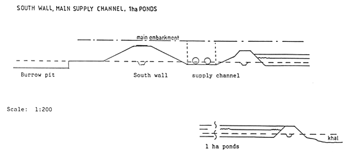
Figure 12 - Supply channel cross-section
| PARTICLE SIZE (mm) | SETTLING VELOCITY (m/sec) | THEORETICAL AREA m2* |
| 0.006 | 0.00001 | 280,000 |
| 0.06 | 0.001 | 2,800 |
| * At SG = 2.5, Q = 10,000 m3/hr | ||
(37) Main drainage is provided through the khal, which requires an additional sluice separate from the present (unofficial) cut through the WDB dike. By constructing a small dividing wall it will be possible to separate the pond drainage from field drainage to the south, and also to ensure that no drainage occurs from the ponds on the adjacent fields (Figure 13). The khal is more than adequately sized to drain the site.
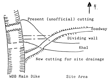
Figure 13 - Khal drainage area
(38) Secondary drainage canals are sized to permit the drainage of 80 % of the pond group volume within 4 hrs, equivalent to the drainage times given in Table 17. Annex D describes the basis for design. The channels can have a relatively steep gradient, subject only to scouring velocity, but are in practice limited by the drop between the pond outlet gates and the channel floor, which should not ideally exceed 0.2–0.3 m to avoid local scouring. As with the supply canals, care must be taken to ensure protection from erosion at critical points.
Table 17 - Drainage canals: summary of design
| Draines | B(m) | D(m) | Flow(m3/hr) | Notes | |
| Main canal | secondaries | variable | 0.5–1.5 | 20–30,000 | Khal, can also store water; |
| Secondary 1 | 3 × 1 ha | 3.0 | 0.5–1.0 | 10,500 | |
| 4 × 0.5 " | |||||
| Secondary 2 | 5 × 0.5 " | 2.5 | 0.5–1.0 | 8,100 | |
| 9 × 0.2 " | |||||
| Secondary 3 | 9 × 0.2 " | 2.5 | 0.5–1.0 | 7,200 | |
| 13 × 0.1 " | |||||
| Secondary 4 | 14 × 0.1 " + lab drainage | 2.0 | 0.5–1.0 | 5,000 | Takes wastes from labs. |
| Note: Maximum freshwater runoff at 30mm/hr is ca. 5000m3/hr; Maximum gradient is 0.002. | |||||
(39) The drainage system will be required to handle fresh water runoff in addition to normal requirements (Annex D). This should normally be feasible; in heavier downpours the pond outlets may be set to allow overflow of surface fresh water, thereby reducing to some extent the potential drop in salinity.
(40) Although not specifically shown on the proposed layout, there exists the simpler alternative of using the khal both to supply and to drain the system. This has the significant disadvantage of limiting flexibility of water exchange potential, and making it impossible to provide continuous water exchange, as is sometimes employed for periods of time in more intensive shrimp culture. The main advantage is simplicity: the secondary supply canal designs can be used (as they are larger), with an increased gradient, connected to the khal. Each pond would then have a single inlet/outlet. This option is however only recommended if budgeting limitations become too severe.
(41) Details of the main gates (supply and drainage) are shown in Figure 14. The design procedure employed is described in Annex D, based on the supply of 60 % of system volume in 15 hrs (2 to 3 high tide cycles) during the lowest spring high tide cycle. Dimensions are detailed in Table 18. Main gates may be constructed either as full height sluices or as pipe culverts with sluice controls at either side of the main wall. In principal it will be smaller and more convenient if possible to provide pipe culverts with an external board sluice and internal steel screwdown sluicegate. In this way there is the means both of selecting the intake level of water from the river and of having a secure water control, particularly if inlet levels and flows become higher than expected.
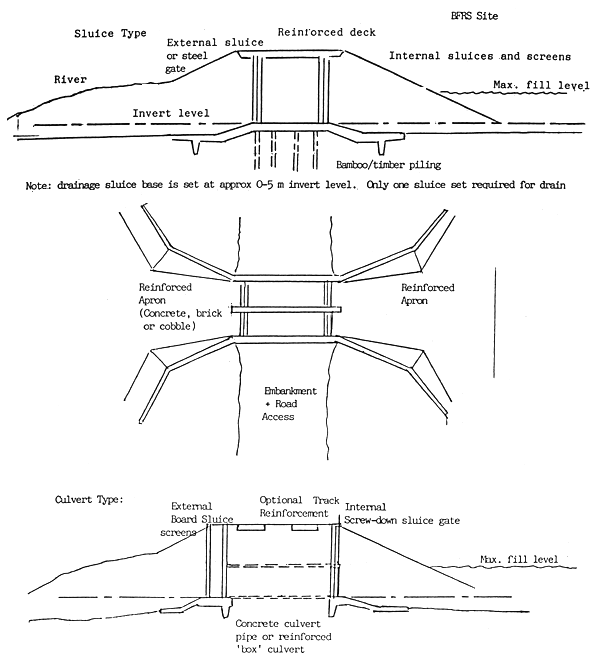
Figure 14 - Main gates
| Location | Flow Avge. | (m3/hr) Max. | Size | Notes |
| Main supply | 7,500 | 22,000 | 2 × 0.8m or 2 × 1 m dia | Concrete culvert with external boards, internal valve; |
| Main drain | 7,500 | 25,000 | 2 × 1 m dia | Concrete pipe, with flap valve, takes rainfall runoff. |
(42) The pump installation, which is optional at this stage depends on the type of pump system finally selected; Figure 15 shows the options. The inclined tube systems, though simpler to install, are usually limited to about 6 m shaft length, beyond which it is difficult to avoid vibration. Not shown, but also possible, would be a submersible pump, but this requires an electrical power supply. Note that in both of the cases shown, the pump installation may be set lower provided adequate protection was provided against extreme flood conditions.
(43) The main drainage sluice is most conveniently provided with a pipe culvert installation, in this case with simple flap valves to allow water out during low tides, and prevent re-entry of water during rising tides. As there is considerable volume in the khal, it is then possible for ponds to be drained into the khal during the higher part of the tidal cycle, thus permitting ‘through-flow’ if required. With the sluice gate on the intake system, it is also possible to fill up a certain volume in the supply canal for recharging ponds during the falling tide.
(44) Details of the smaller water control structures at individual ponds are given in Figure 16. For the 1 ha and 0.5 ha ponds, conventional wooden sluices are suggested for intakes, while 0.2 ha and 0.1 ha ponds can be supplied by a pipe. In all cases, inlets should be suitably screened (normally 1–1.5 mm screening) and well keyed into the surrounding wall, to prevent seepage and settling. Pipes can be used as waste outlets in all cases. Sizes, allowing also for fresh water flood drainage, are given in Table 19. Design details are provided in Annex D.
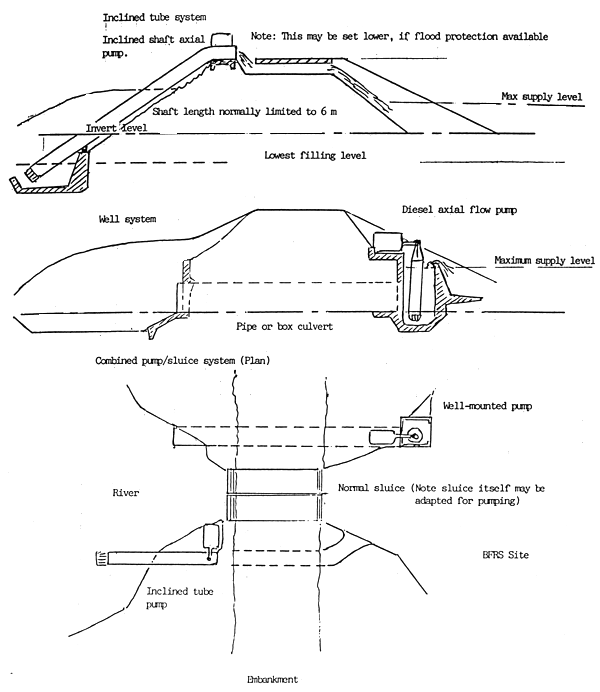
Figure 15 - Pump installation
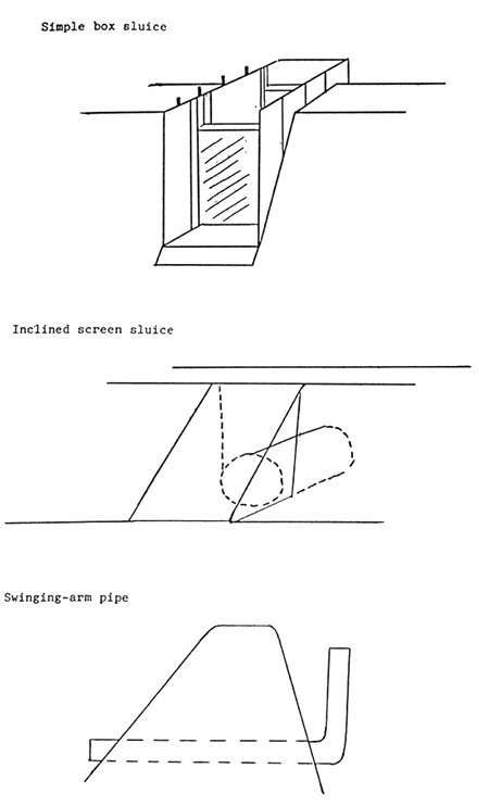
Figure 16 - Smaller water control structures
Table 19 - Waste pipe and sluice sizes, mm
| Pond | Drain | Q,m3/hr | Sluice | 1 pipe | 2 pipes* | |
| ave. | max. | width | dia | dia | ||
| 1 ha | 5 hrs | 2000 | 6000 | 300–400 | 400 | 300 |
| 0.5 " | 4 " | 1250 | 3750 | 300–400 | 350 | 240 |
| 0.2 " | 3 " | 667 | 2000 | 200–300 | 250 | 180 |
| 0.1 " | 2 " | 500 | 1500 | 200–300 | 250 | 160 |
| * One pipe is used for normal level control, the other used in addition when rapid draining is required. They can be set at different levels, so only one drains the lowest sump area, and is used for harvesting. | ||||||
(45) Access around the site is provided by a roadway suitable for four-wheel drive vehicles along the southern boundary wall, with a series of simple timber/bamboo bridges across supply and drainage channels. These would be suitable for foot traffic and small carts. If required, pipe culverts could be used at specific crossings to provide for a central vehicular access within the site. Generally, the channel side walls are sufficient for foot and cart access, while walls between ponds are adequate for walking only. Access to boat transport will be via the road to the main dike; the boats may be housed or moored near the intake area.
(46) The main road area should at least be bricked, ideally with a generous layer of coarse chip below it, and adequate side and embankment - wall drainage to minimize erosion effects. At least 2 m track width should be provided.
(47) Several different options of pond levels, wall sizes and imported fill quantities were investigated (Annex D). Summarized results are provided in Table 20. The third option, CASE C, is recommended, if possible, permitting reasonably well-sized walls with not too much lowering of pond levels or use of fill material. On this basis the borrow zone required extends to approximately 40 metres from the southern wall, assuming an excavation depth of 1.5 metres.
Table 20 - Material balance: use of borrow pits
| Case A: Normal wall volumes, minimal pond excavation | Case B: Minimal wall volumes, maximal pond excavation | Case C: Moderate wall volumes moderate pond excavation | ||||
| +m3 | -m3 | +m3 | -m3 | +m3 | -m3 | |
| External wall | - | 16,400 | - | 16,400 | - | 16,400 |
| Internal wall | - | 6,400 | - | 4,400 | - | 5,000 |
| Secondary supply/walls | - | 9,600 | - | - | - | - |
1 ha ponds | - | - | - | 560 | - | 1,200 |
Others | - | - | - | 3,140 | - | 4,590 |
| Secondary drainage/walls | 800 | - | 2,725 | - | 5,850 | |
| Pond walls | - | - | - | - | - | - |
1 ha | - | 7,000 | - | 1,320 | - | 1,980 |
0.5 ha | - | 12,000 | - | 3,850 | - | 4,125 |
0.2 ha | - | 11,400 | - | 2,860 | - | 3,900 |
0.1 ha | - | 12,600 | - | 3,190 | - | 4,350 |
| Building area | - | 3,000 | - | 3,000 | - | 3,000 |
| Margin, 10% | - | 7,760 | - | 4,145 | - | 5,040 |
| Total | 85,360 | 45,590 | 55,435 | |||
| Pond fill | ||||||
1 ha | 3,000 | - | 15,000 | - | 9,000 | - |
0.5 ha | 4,500 | - | 9,000 | - | 4,800 | - |
0.2 ha | 3,600 | - | 7,200 | - | 4,300 | - |
0.1 ha | 2,700 | - | 5,400 | - | 3,200 | - |
| River bank | 4,000 | - | 4,000 | - | 4,000 | - |
| Total | 17,800 | 40,600 | 25,300 | - | ||
| Balance | 67,560 | 4,990 | 30,135 | |||
| Borrow pits of -m width, @ 820 m3/m | 82.39 | 6.09 | 36.75 | |||
![]()
![]()
![]()