![]()
![]()
![]()
We, and all the other living organisms on this planet, exist within a relatively narrow range of physical and chemical conditions. The geological record shows that these conditions are self-regulating to a degree, but that they are not guaranteed to remain within tolerable limits.
It is clear that the human species has altered both the global land surface and the composition of the atmosphere, but we do not know how much change can be tolerated before the processes on which we depend, such as the global climate, adjust to a new state which may make it impossible to meet our basic needs.
Even more fundamentally, we lack globally comprehensive environmental observation systems to provide the data essential for sound policy formation and planning. The data gaps lead scientists to draw opposing conclusions on whether certain impacts of global change on terrestrial ecosystems will be negative or positive. For example, there are strongly differing views as to whether anthropogenic impacts are going to have regional or global consequences for food production in the next 10 years or the next 100 years.
This proposal for a Global Terrestrial Observing System (GTOS) is therefore designed to correct these weaknesses, and to improve our ability to manage the planet wisely for future generations. It is founded on six critical facts:
There are a number of today's environmental problems that are global in nature, or at least are so common to nations that they amount to global problems.
These environmental problems are frequently caused or reinforced by unsustainable land-use and other anthropogenic impacts on terrestrial ecosystems including unmanaged ‘natural’ ecosystems, managed agro-ecosystems and freshwater aquatic ecosystems.
We lack the data to detect, monitor or understand (a) how, where and over what time frame we are endangering terrestrial ecosystems and (b) the role of terrestrial ecosystems in global processes like climate change. In particular, there is no existing observing system which can provide the baseline against which future changes can be assessed with a high degree of confidence.
Global change phenomena including those relating to sustainable development are generally interactive, long-term in their expression, and supra-national or supra-regional in their extent or impacts. However, existing observing systems to detect and help understand these phenomena are generally sectoral and only weakly integrated, sub-global in practice though their objective may be global coverage, and focused on the short-term.
Increased remote sensing capabilities and coverage plus technological progress in site instrumentation and electronic data handling and transfer now provide cost-effective means of overcoming the deficiencies in existing observing systems.
Much of the terrestrial data collection is for biophysical research. It is not matched by the collection of socio-economic data on the driving forces for ecosystem change, and there is insufficient focus on their use in policy formulation and implementation.
Whilst the need for integrated and systematic terrestrial ecosystem monitoring has been recognized for more than one hundred years, there was no substantive international action to achieve it until the early 1970s. The Stockholm Conference on the Human Environment in 1972 catalysed a number of monitoring activities, particularly Earthwatch and the Global Environment Monitoring System (GEMS), which have made a positive contribution. But collectively they fall well short of what is required. Most of these activities are sectoral and lack the resources to be truly global. Their sectoral nature, limited geographical coverage, lack of integration and generally short-term duration prevent or limit the determination of changes in the magnitude, trends, interactions and synergisms in terrestrial processes that may be discontinuous in space and time. These changes must be identified, measured and understood to provide a sound basis for national and international policies addressing global change problems. UNEP/HEM has catalogued over 80 independent activities which are partly or wholly designed to monitor terrestrial ecosystems or components thereof (Tsai-Koester 1994). Individual UN agencies are responsible for some of these activities, and regional or national bodies extend the depth, breadth and continuity of such activities, but there is no overall framework into which they can fit. Yet these existing activities could provide a spatially extensive and cost-effective foundation for GTOS. There are more than 3,000 funded and operational sites of potential relevance to GTOS, which are engaged in terrestrial and freshwater monitoring at various levels (Table 1).
Table 1 Global distribution of some ecosystem monitoring sites of potential relevance to GTOS. In brackets (): number of sites which have expressed interest in contributing to GTOS (Tab. 10).
Source: calculated from Reid and Edwards 1995 and Tab. 8, 9 and 10).
|
|
|
Number of sites |
|
|
|
|
Terrestrial |
|
Fresh water |
|
|
North America |
502 |
(87) |
North America |
77 |
|
South America |
73 |
(10) |
South America |
31 |
|
Central America & Caribbean |
37 |
|
|
(3) |
|
Sub-Saharan Africa |
134 |
(14) |
Africa |
95 |
|
North Africa & Middle East |
50 |
|
|
(5) |
|
East Asia |
93 |
(38) |
Asia |
51 |
|
South Asia |
46 |
|
|
9) |
|
North Eurasia |
|
|
|
32 |
|
Europe |
1713 |
(174) |
Europe |
332 |
|
Greenland & Arctic |
3 |
|
|
(2) |
|
Australia & New Zealand |
57 |
(5) |
Australia/NZ |
23 |
|
Oceania |
4 |
|
|
|
|
Antarctica |
4 |
|
|
|
|
Total |
2748 |
(347) |
|
609 |
It should be noted that progress has been made in establishing a comprehensive Global Climate Observing System (GCOS), and parts of a Global Ocean Observing System (COOS). Terrestrial and freshwater ecosystems, however, which are a key factor in both GCOS and COOS (particularly regarding the coastal zone), and are vital to human survival and global processes, are seldom observed other than at the local level.
Quantitative and qualitative improvements in terrestrial ecosystem data collection are, therefore, vital for better natural resource planning and early warning of global change, and its regional and local implications. Key improvements include data on the spatial extent of terrestrial ecosystems, the inherent variability of ecosystem function and structure, and the direct and indirect effect of human activities on ecosystem processes and responses together with the other gaps given in Box 1.
|
Box 1: Some critical data gaps · Systematically collected, compatible and geo-referenced land-cover and land-use data that can provide accurate information on their rates of change of use; · Data on socio-economic driving forces which can be associated with the above; · Land degradation and changes in soil properties and their contribution to global change processes including carbon sequestration; · Integratable field, watershed, water basin and estuarine data on soil erosion rates, deposition within the landscape, sediment loads and inputs to the coastal zone; · Reliable and globally comprehensive data on snow cover, snow pack and soil moisture for climate prediction; · Adequate measurements of carbon flux between the land and the atmosphere; · Reliable and comprehensive data on other greenhouse gas fluxes; · Ozone and other toxic gas concentrations; · Data to determine changes in biodiversity and ecosystem function. |
These improvements are also essential for the derivation of sound indicators of changes in the quality of natural resources (e.g. soil and vegetation). Such indicators can play an important role in assessing the effectiveness of natural resource management policies, and in guiding financial resource allocation at the national and international level, for example by indicating to Ministries of Finance or to the Global Environment Facility the relative importance of competing demands on their funds.
This proposal builds upon the suggestions made at Fontainebleau in 1992 (Heal et al 1993), but shifts the balance of emphasis to bring them more closely in line with needs of the Rio Declaration and Agenda 21.
In particular it addresses two concerns:
It gives more consideration to managed agro-ecosystems. Much of the available evidence points to a slowing down of the direct anthropogenic pressures on natural ecosystems at the global level and continental level, but an acceleration of those on existing agro-ecosystems through rapid population and/or income growth. For example, much of the land well suited to agriculture is now in use. Consequently, pressures on natural ecosystems from deforestation and other forms of agricultural land extension are projected to slow down over the next 25-40 years to about a quarter of a percentage point per year (Alexandratos, 1995), though still with severe problems at the local and regional level. However, pressures on biogeochemical cycles from agricultural land-use intensification seem likely to increase as growth in crop yields, cropping frequency, and input use have to compensate for the lack of new land to exploit.
It gives more thought to the needs of the developing countries and to policy planners, rather than concentrating on those of the scientific community, but without ignoring the vital role of the latter in the policy planning process.
Terrestrial Ecosystems are the foundation for social and economic well-being because they provide:
The primary and largely irreplaceable source of food, fuel, and materials for clothing and shelter;
The main source of employment, income and material welfare for about half the world's population. For many developing countries, they are the dominant economic sector through commodity exports or tourism;
Sources of freshwater for drinking, irrigation and industry;
The major source of nutrients (and also pollutants) for coastal zones and the oceans. They influence fisheries productivity - the other main source of food and provide employment to millions of fishermen, fish processors and retailers;
The home for much of the genetic diversity that sustains current agricultural systems and that provides the basis for predictable future natural resource needs and insurance against unknown new threats which may arise to human health and agricultural systems;
Visual beauty and recreation.
Terrestrial ecosystems are also the major drivers for the atmospheric, biogeochemical and hydrological processes that shape and govern life on earth. In particular they:
Play a primary role in soil formation and maintenance;
Are a co-determinant of the surface energy balance through reflection, absorption, transmission, and transformation of radiative energy from the sun, and of the global hydrological cycle;
Affect the storage and flow of surface and groundwater resources, and influence their quality;
Are a source and sink for greenhouse gases, and provide major pathways for and influences on biogeochemical cycles;
Receive, filter, buffer and transform nutritious and hazardous anthropogenic materials.
There are uncertainties about the ability of terrestrial ecosystems to sustain current production of food and other goods and maintain environmental services. There are even greater uncertainties about their ability, to meet and sustain indefinitely, the growing material and welfare needs and expectations of a human population which could double by 2050, in association with a possible quadrupling of per capita incomes over the same period.
Uncertainties surround the very basic question as to what is the sustainable population-supporting capacity of the world. Some argue that it is 8 billion (Meadows et al 1992), which is clearly not compatible with the levelling off of global population currently projected at between 10 and 12 billion by the year 2050 (UN 1994). Others calculate that land-based food production could support a population considerably greater than 12 billion, even with an environment-oriented agriculture that minimizes the use of mineral fertilizers and pesticides (De Vries et al 1995).
These concerns and uncertainties about the ability of terrestrial ecosystems to meet future global needs are repeated at the local and regional level, where it has been suggested that population pressures are bringing terrestrial ecosystems to the point of collapse. In Southern Africa, for example, some analysts conclude that overgrazing is causing widespread erosion and rangeland degradation beyond the point of recovery. Other analysts - using more dynamic models with fuller representation of soil types and ecological processes - conclude that current livestock populations and productivity can be sustained for some 200 years (White 1992, Biot 1993). Such differences arise in part from lack of basic data, and will continue until there is regularly collected and compatible data on land cover and land-use change, rates and extents of land degradation, and shifts in ecosystem structure and plant productivity through soil erosion.
Such uncertainties are a major constraint to development strategies and policy planning at all levels from the local to the global. The removal of these uncertainties is highly dependent on the type of data and understanding that GTOS is designed to supply, and for which there is no other adequate mechanism.
Climate change is one of the major areas of uncertainty. Although there is a scientific consensus within the IPCC that global average temperatures could rise 1.5-4.0 degrees centigrade by the middle of the next century, there is great uncertainty about the timing, spatial distribution and impact on terrestrial ecosystems of such a rise. Predictions from the various General Circulation Models (GCMs) are not in agreement, for example, regarding the nature of regional shifts and impacts of climate change. It is generally recognized that some of the refinements required in these models to improve their predictive powers are dependent on better data on land surface properties, terrestrial ecosystem processes and possible responses to climate change. Consequently, it has been recommended that GTOS, as part of its support role to GCOS, should be the primary mechanism for the collection of such data. Moreover, the uncertainties related to climate change go beyond questions of temperature and moisture distribution. They include changes in carbon sinks to sources that may affect plant growth, and alterations to low-level UV-B and ozone concentrations which could have adverse effects on human health and crop growth.
In addition, the GCMs as with biogeochemical, hydrological, and other global change models, need to be calibrated more accurately, and coupled more closely with regional or zonal models, and with ocean circulation models. One of the key requirements for such improvements is better terrestrial data, especially on land cover and land use change, on trace gas and dust (including volcanic dust) fluxes from terrestrial ecosystems, and carbon sequestration. GTOS is the only way of getting comprehensive, continuous, and comparable data of these types.
Many countries suffer from gaps in their scientific and technical infrastructure, and hence lack some of the data, technology or trained manpower for sound decision-making. In particular they are unable to take advantage of today's possibilities for the integration of traditional data sets with those derived from remote sensing, spatial databases and using global positioning systems. GTOS would help to overcome these gaps in two main ways:
Through the creation of better natural resource inventories and more reliable information on the status of terrestrial ecosystems. Many developing countries, for example, have been unable to prepare comprehensive and accurate land-use inventories for one to two decades or more. Consequently, they are faced with considerable uncertainties about the area under forests or major crops, with some estimates being subject to errors well in excess of plus or minus 50%.
By providing improved access to more advanced monitoring, data management and data exchange technologies; by increasing the opportunities for the training of their technical and research staff, and by supporting better links and information sharing between scientists and policy analysts in countries facing or overcoming similar terrestrial ecosystem problems.
A number of international conventions have introduced legal requirements or obligations for countries to provide data and information relating to terrestrial ecosystems to UN or regional bodies. Such data or information can more easily or effectively be obtained through a mechanism like GTOS, which ensures international comparability (Box 2). These conventions include those on Climate Change, Biodiversity, and Desertification. GTOS would also greatly assist the more general reporting on the state of the environment to the Commission on Sustainable Development and other bodies. For example, GTOS-derived data on land cover, land use and trace gas fluxes could make an important contribution both to national natural resource planning and to the fulfilment of greenhouse gas inventory reporting requirements under the Framework Convention on Climate Change. Recent attempts to prepare such inventories have been severely constrained by the lack of reliable data.
|
Box 2: Terrestrial Monitoring Requirements of the Post-Rio Conventions CONVENTION ON BIOLOGICAL DIVERSITY Article 7. Each Contracting Party shall:
FRAMEWORK CONVENTION ON CLIMATE CHANGE Article 4. All Parties... shall:
CONVENTION TO COMBAT DESERTIFICATION Article 16. The Parties agree, according to their respective capabilities, to integrate and coordinate the collection, analysis and exchange of short term and long term data and information to ensure systematic observation of land degradation in affected areas and to understand better and assess the processes and effects of drought and desertification.... To this end, they shall, as appropriate:
|
There are two major investments where the gains could be particularly, important. First, there are those in existing terrestrial ecosystem monitoring, where the lack of internationally, agreed protocols and terrestrial ecosystem classifications result in large national or even sub-national data sets which are not compatible, and therefore cannot be used collectively for global analysis. The harmonization of data sets that could be achieved through GTOS would help to overcome this problem, and make it easier to place national data into their regional or global contexts. Second, the hierarchy of 'standardized' monitoring sites for in situ observations proposed later, and particularly the statistically representative series of some 10,000 less intensive sites, could provide a permanent ground truthing system for the vast current and planned investments in earth observation satellites. Such sites could play a very important role in the calibration and performance monitoring of satellite borne sensors.
The scope of GTOS is set in two ways. First, by certain key development issues and second by its defining characteristics.
The development issues are questions and uncertainties of global concern that face natural resource use planners, other decision makers and the research community. They are influenced by the deficiencies in the existing observational systems.
The Planning Group (PG) made an assessment of key global change and national development issues along thematic lines, because GTOS must be directed at specific needs and not at data collection for its own sake. These issues primarily concern anthropogenic impacts on terrestrial ecosystems, and particularly:
Land-use and land-cover change, land degradation and the sustainability of managed ecosystems;
Water resources management;
Pollution and toxicity;
Loss of biodiversity;
Climate change.
These issues are considered in depth in Part II, together with an assessment of the main data and information gaps. In the light of this assessment the PG proposes that five key questions vital to sustainable development should receive priority in the determination of the scope of GTOS (Box 3).
|
Box 3: Five key questions which GTOS must help to address · Food and renewable resources: how much spare capacity does land have to support additional demand, and where is it? · Fresh water: where will quantitative or qualitative demands exceed available supply, when and by how much? · Hazardous substances: where and when do they reach a level threatening human and ecosystem health and the capacity of ecosystems to detoxify them? · Biological diversity: where and what type of biological resources are threatened with loss, and where will these losses irreversibly damage ecosystem function? · Terrestrial ecosystems: where, when and how much will they alter in response to resource use, land use and atmospheric (including climate) changes, and how will this impair their regulatory functions capacity to sustain life? |
The scope for GTOS is also set by its defining characteristics. In order to make a unique contribution to our ability to manage the planet wisely, GTOS must have three defining characteristics (Box 4).
|
Box 4: Three defining characteristics for GTOS · It must be global in scope, meaning both that its coverage should be comprehensive and it should address phenomena that are global in their nature or impact; · It must provide continuity of information collection over the long-term i.e. periods from years to decades which are consistent with the rate at which global processes occur in order to detect trends sensitively and in a timely fashion; · It must be an integrated system in which the separate pieces of information add to each other's value. For example, GTOS data must not only detect and describe changes, but allow them to be understood and predicted. |
These two sets of determining factors (Boxes 3 and 4) shape the GTOS mission statement (Box 5), and set the guiding principles for the design of the observing system itself.
|
Box 5: GTOS Mission Statement The central mission of GTOS is to provide policy makers, resource managers and researchers with the data needed to detect, quantify, locate and give early warning of changes (especially reductions) in the capacity of terrestrial ecosystems to support sustainable development and improvements in human welfare, and to help advance our understanding of such changes. It should be accomplished through the development of an equitable partnership between generators and users that meets both the short term needs of national governments and the longer term needs of the global change research community. GTOS data collection should have four main objectives:
These four objectives should be realized by:
|
There is one other issue regarding scope which needs to be addressed - the extension of GTOS to cover socio-economic driving forces. The PG believes that socio-economic factors must become an important part of GTOS as they are the major driving force for changes in terrestrial ecosystems. It is increasingly recognised that improvements in our understanding of terrestrial ecosystem change, and in the predictive powers of GCMs and other global change models, are critically dependent on the greater integration of the data on and the analysis of socio-economic driving forces and the biophysical and biogeochemical responses. GTOS should therefore make a major input to this integration, and may be the only practical way of assembling the required integrated data sets.
The development of GTOS should be closely coordinated with national and international activities, e.g. CIESIN and HDP, to assemble socio-economic databases. This coordination should give priority to reaching agreement with the main parties concerned on (a) the key, anthropogenic variables to be measured (population distribution, incomes, and related factors like road infrastructure) and with what spatial and temporal resolution; and (b) protocols and other measures to ensure that the terrestrial and socio-economic databases can be fully, integrated.
Various principles should guide the design of GTOS. They emerge from scientific understanding of terrestrial ecosystems, from statistical theory and from the experience gained with other systems. The principles are related to four issues: sampling design, variables to be measured, data documentation, and data use. The principles are outlined below and elaborated in Part II.
Sampling design is important because you cannot measure everything everywhere. It is neither possible, nor desirable, to have total information. It is, however, essential to sample in a way that allows reliable inferences to be made about the unsampled remainder Most processes have a characteristic temporal and spatial rate of variation which can guide the frequency and location for optimal sampling.
Regarding variables to be measured, it is necessary to first identify the key questions regarding terrestrial ecosystem change and then determine the core data needed to address them. The questions should be sufficiently specific to be answerable, but fundamental enough to be widely relevant. Direct data is preferable, but indirect data collection may be necessary.
It is not enough to know that something has changed: in order to manage that change it is essential to know what has caused it. No matter how useful the information, the system has to be, and to remain, affordable at all levels, from local to global.
Data documentation is vital. The data management system must be a comprehensive metadata system, carrying pointers to where the data is held. Responsibility for agreed quality assurance procedures should be devolved as close as possible to the point of collection. If data use is to be properly supported, the observing system must be designed to deliver useful information at the scale needed to guide decisions: the whole must be greater than the sum of the parts.
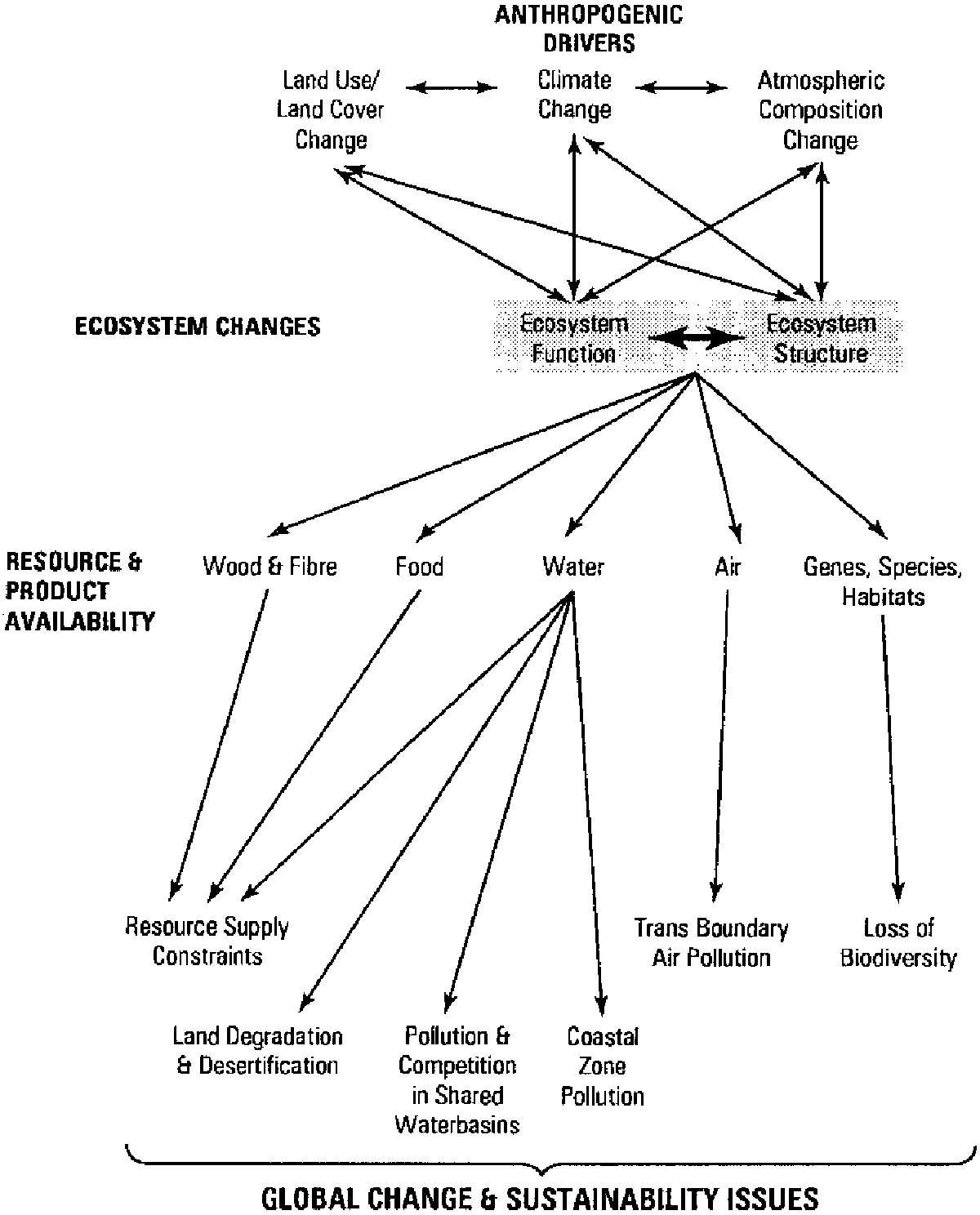
The requirement for GTOS to be global, integrative and long-term has led to the conceptual structure illustrated in Figure 1. It is centred on the five broad questions presented in Box 3 which are fundamental to sustainable human development. Each of them clearly has component questions which must be addressed, for example, on the rates of soil erosion and the degree of reversibility. Moreover, the major development issues and key questions are also part of the conceptual framework, since most of them are inter-related are in some way, and are a largely a function of socio-economic driving forces.
Figure 1 GTOS Conceptual Framework
GTOS's principal task should be the establishment and then the coordination, operation and maintenance of an in situ terrestrial observation system. The most efficient way of achieving this system is by forming a partnership of partnerships based largely on suitably located and equipped existing sites and networks such as CERN, LTER and ROSELT. This core activity should be formally linked to complementary activities, notably:
On-going media related systems like GAW, GEMS/AIR, GEMS/WATER and GRDC, and those like WHYCOS which are in the process of development;
Ecosystem conservation focused activities e.g. the MAB Biosphere Reserves and WCMC;
Present and planned remote sensing programmes of CEOS including the Pathfinder Project.
Implementation should be essentially bottom-up with GTOS providing the framework, within which the output from (a) the space-based Earth Observing Systems, and (b) the existing databases such as GEMS/WATER can be integrated with land use and related data from other sources. Observations should be centred on providing the data required for nations/international agencies to improve their assessment of the extent and sustainability of terrestrial ecosystems, to give early warning of major threats to global development and welfare and hence to increase the time available for mitigation. Actions should be both direct and catalytic, for example, by influencing decisions of CEOS and individual space agencies regarding remote sensing activities and sensors.
Wherever possible, common procedures and common modules should be established with GCOS and GOOS, for example in methods of data management and space data collection, land-climate (with GCOS) and land-coastal zone (with GOOS) modules respectively.
Research should not be a major function of GTOS. Instead it should support research programmes and collaborate with IGBP (e.g. BAHC, GCTE, LOICZ, LUCC), WRCP, DIVERSITAS and others in the identification and assembly of appropriate data sets or their precursors. However, some research may be necessary into the transformation of data into products suitable for under-resourced users, which could be done by the coordinating unit, through external contracts, or by collaborating institutions on behalf of GTOS. It may also be necessary to encourage technical studies, for example to improve instrumentation.
The main actions to achieve the above are outlined below and detailed in Part II of the proposal.
It is preferable that one organisation should take overall responsibility for the implementation of GTOS. The main options from amongst the UN agencies would appear to be FAO or UNEP, since they both have mandates which require GTOS type of information. But there are a range of other international bodies that might take on the task. Other UN agencies, public bodies or NGOs might take responsibility, for particular activities, WMO for hydrological aspects for example and UNESCO for those biosphere reserves with monitoring capabilities.
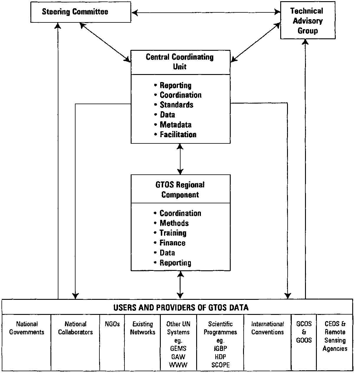
The proposed institutional framework is presented in Figure 2. The proposal seeks to achieve a flexible bottom-up structure founded on the needs and capabilities of a wide range of users and which is consistent with GTOS's extensive mandate. Complete global or regional coverage is not envisaged as part of the initial plan. Regional components should evolve in response to user initiatives at the regional or national level rather than being part of a pre-set structure.
Figure 2. Proposed GTOS structure
GTOS should be guided at the strategic level by a Steering Committee (SC) comprising representatives of the major sponsors and principal collaborators such as IGBP and CEOS, representatives from each of the main UN regions, and some independent users of GTOS data.
The Steering Committee should be supported by a Technical Advisory Group (TAG) composed of some fifteen leading individuals in the fields of terrestrial ecosystem monitoring, ecosystem and global change modelling, data management natural resource policy planning. Members would be appointed in their own right and serve for an initial period of three years and a maximum of six. There should be an acceptable balance in the membership between managers, generators and users of monitoring information, scientific disciplines and geographical experience.
The SC and its TAG would be too small to involve the diversity of users and breadth of the existing terrestrial monitoring networks, who could be regarded as the real owners of GTOS. The Planning Group therefore recommends that the TAG is supported by some 40-50 corresponding members who would contribute to and/or comment in writing on documents prepared for the SC. These might include managers of national observing systems and representatives of IUCN, WCMC and similar bodies, and of major potential users like the World Resources Institute.
In addition, there would be the need for ad hoc or permanent supporting bodies to guide the development of operational plans for particular functional or thematic components of the programme. It is envisaged that these would include bodies for data management and space observation needs, and could be joint activities with GCOS and GOOS. The selection of thematic groups could mirror the six issues/themes given on the opening page of this part of the proposal, and should include the existing GCOS/GTOS Terrestrial Observation Panel for climate change aspects.
The organization with overall responsibility for GTOS should establish a small Central Co-ordinating Unit (CCU) as early as possible and preferably in the first half of 1996. CCU should comprise two to three professionals in the initial years, building up to five or six within five years. The organization should introduce the financing of this unit into their core-funded programme by the end of 1998, so as to ensure continuity of operation. The initial task of the CCU central unit would be to co-ordinate the creation of agreements on data protocols etc. and the linkage of existing sites and networks into the overall framework.
Regional bodies or contact points should be established to assist the above coordination and to play a central role in the establishment of cost-effective solutions to national monitoring requirements. Finance permitting, they could form a repository for pooled resources and undertake collective or designated actions on problems or technical solutions of common interests, with training and capacity building as one of their main tasks. The Planning Group recommends that the regional components should be an emergent property of the system, with both the number and speed of establishment being agreed by groups of national data providers and users. Existing bodies such as the START office for Asia or the UNEP regional offices could help to initiate such actions, and possibly be the centre for regional GTOS components. In the early stages they could consist of one or two staff based at such existing units. Similarly, the operational mechanism at the national level should remain flexible so as to accomodate a range of national preferences.
Monitoring sites and variables must be selected and prioritized on the basis of clear conceptual models, development issues and key questions. Specific recommendations are given in Part II.
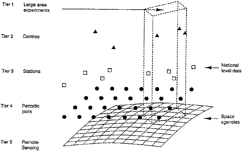
The observational system should be structured hierarchically in the manner illustrated in Figure 3, outlined in Table 2, and detailed in Part II. This structure embraces and extends the hierarchical framework suggested by the GCOS/GTOS Terrestrial Observation Panel, so as to include other non-climate-change-related observations.
A mechanism will be needed to link selected monitoring sites and environmental monitoring networks into a common framework. There are several options. The PG's preferred option is for one central coordinating mechanism for all terrestrial ecosystems and operated by the organization with overall responsibility for GTOS. An alternative if financial and manpower resources are limiting is to have a linkage mechanism centred on two or more networks, for example one dealing with long-term agronomic experiments and managed agro-ecosystem sites, and another dealing with natural, relatively undisturbed ecosystems. The former could possibly be located at FAO given their mandated role as the UN centre for monitoring forest cover and land-use, soil status, and mineral fertilizer inputs. The latter could be an extension of the MAB-Biosphere Reserve network financed and operated by UNESCO, or else subcontracted to an institution already engaged in ecosystem monitoring.
Table 2 A summary of the sampling hierarchy structure. The principle applies to terrestrial unmanaged ecosystems, agro-ecosystems, lakes, rivers and estuaries. Details of the variables proposed at each tier are contained in Annex 4.
|
Tier |
Order of sample numbers |
Sample area (km2) |
Example variables |
|
1 Large-area Experiments and gradient studies |
10 |
1000 |
Boundary layer gas exchange, biome shifts |
|
2 Long-term research centres |
100 [400 ecological, 400 agricultural, 50 rivers, 50 lakes, 50 estuaries) |
10 |
Energy, water, carbon and nutrient cycling |
|
3 Field stations |
|
1 |
Crop yield, ecosystem productivity, land use |
|
4 Periodic, unstaffed sample sites |
|
0.01-0.1 |
Land cover, soil state |
|
5 Frequent low resolution remote sensing |
|
0.001-1 |
Leaf area dynamics, land cover |
Figure 3 Tier structure of sampling strategy
As already outlined, guiding principles for GTOS's data management system should be common to or compatible with those for GOOS and GCOS.
The data management system should be constructed, as far as possible, using off-the-shelf application tools and pre-existing or planned communication systems. It should be sufficiently flexible to incorporate or link to data sets originating outside GTOS, since GTOS may not hold much of the data but provide an access mechanism for dispersed data sets. Much of the data system could be on-line, but the data in it need not be immediately up-to-date. A realistic elapsed time between data collection and its appearance in the data record is weeks to months. Data links between the centre, the regions and other data centres would be primarily electronic, with magnetic and optical disks as a parallel alternate system, especially during the transitional period until all participants have equal access to electronic networks. The user interfaces should be standard regardless of the medium of data exchange.
Activities should focus on setting up of an information system consisting of:
Databanks for in situ observations, processed observations, remotely-sensed images and products derived from them, such as land cover classes;
A data referral system, which would point to the location and type of data. Such data could be either within the GTOS system or outside of it;
Metadata, i.e. descriptions of the origin, method of determination or derivation, quality and limits to the interpretation of all variables;
Models, interpretative tools and decision support systems which had passed peer scrutiny;
Tools for entering, searching, sorting, grouping, summarising, graphing and exchanging data.
The structure of the data system should be distributed, possibly with a global centre and regional centres of approximately the same size. There would be standard analysis, interpretation and reporting functions at both global and regional levels. Large-volume associated data sets, such as satellite images, would be accessible through the system, but not necessarily stored manipulated or maintained within it. Similarly, models are not part of the system, but modellers would draw data from it and return results where appropriate.
The feasibility of GTOS is enhanced by three important facts relating to its short-term benefits and relatively low costs. First, a substantial proportion of the required infrastructure is already in place and funded, so the incremental costs are low especially when compared with the benefits and compared with the costs of a totally new system. Second, it will provide essential products within five years of its establishment. Third, it would improve the returns from major investments on earth observation satellites and remote sensing devices by providing comprehensive ground truthing, and from investments in national monitoring activities by increasing the information which can be generated from the same data collection effort.
GTOS would start with a tremendous advantage in terms of costs, namely that:
There are over 2,500 natural and at least 400 long-term agricultural ecosystem sites, that are already funded at a total cost of over US$ 300 million per year, which undertake limited through to intensive monitoring relevant to the global change and sustainable development questions that GTOS must address (Table 1 and Figure 4). About 250 of the former and 100 of the latter have already expressed interests in becoming part of GTOS. Many of these sites already monitor at least some and commonly a high proportion of the recommended core variables. In addition many of them are in national, regional or global networks which are also funded.
The main gap in the site hierarchy is at tier 4 (see page 17). Most of these sites do not exist at present although they have similarities with the some of those in the UK Countryside Survey, and some agricultural research stations. However, given the limited number of highly standardized measurements and the proposed five-year sampling interval, the costs will be low compared with those of the other tiers (see Annex 8).
Recent technological developments make it financially feasible to improve the measurement of certain variables, e.g. continuous tower measurements of carbon dioxide, and possibly methane and nitrous oxide fluxes. Some of these sites already make such flux measurements, and others plan to do so, and hence a small number of other sites enhancements may be required. In the main, enhancement costs will be generated through the research community rather than by GTOS. In the case of some developing countries, however, GTOS may need to play a strong supporting role in the search for external funding.
World Wide Web already provides a low cost mechanism for data exchange and transfer for those with access to Internet, and current plans of major software developers could reduce the cost and widen the number of observing centres and sites that are able to interact electronically.
Existing data centres and data management structures could undertake a number of GTOS's requirements, e.g. the World Data Centres, GRID, WCMC and international centres like that of NOAA.
There is substantial flexibility regarding the way that the cost of launching GTOS can be met. The proposed plan can readily be phased over a number of years, and built up from modules, such that multiple financial mechanisms could operate, with individual donors supporting those modules that are consistent with their issue or regional priorities.
Figure 4 Global distribution of
some ecosystem monitoring sites of potential relevance to GTOS (cf Table 10,
TEMS 1995)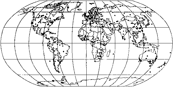
Just linking together the existing monitoring sites and networks under a standardized and suitably harmonized data collection and management system at a cost of US$ 300-500k per year would provide significant benefits for the scientific community and for the UN agencies and international conventions whose mandates require such data. But it would not, for example, provide the improved land cover and land-use data, and the C02 flux information that many developing countries need. Nor would it provide the spatial coverage of biomes and agro-ecosystems and the range or temporal frequency of measurements that are required to improve GCMs and raise their ability to project more accurately the possible timing and regional impact of climate change.
GTOS could be launched at an average annual operating cost of less than US$1 million for the secretariat/central coordinating unit, guidance bodies, and initial networking. This would be less than 0.5% of current expenditure on terrestrial monitoring. It could build up over five years to about US$3.4 million for operating costs and some US$8.6 million for capital costs if the resources can be found to extend regional activities, and to fill gaps in the spatial coverage of monitoring sites in developing countries (Annex 8, Tables 11 and 12). Spatial gaps in the developed countries are assumed to be funded directly by them. The costs of tier 5, the low and high resolution remote sensing activities, have not been included. It is assumed that a large proportion of these tasks are already included in the programmes of other public and private sector bodies like CEOS and IGBP-DIS, and it is recommended that GTOS collaborates with GCOS and GOOS in preparing a fully-costed proposal that meets their combined needs and demonstrates the combined benefits to CEOS and others of these additional activities.
Costs could be lowered by limiting activities and spreading the implementation over a longer period. The proposed regional activities, for example, are a substantial part of the costs. The Planning Group acknowledges that such funding may be difficult to obtain in the current financial climate, but considers that these activities have a vital role to play in gaining developing country participation. Initially the regional activities could be coordinated by one professional plus support staff, with funds for capacity-building activities, like workshops and training programmes, coming from UNDP or bilateral sources. If they were based at tier 2 or 3 sites, or at existing institutions like the START regional offices, then they would not need to establish supporting infrastructure.
There are other implementation options, which have implications for total costs and their allocation. For example, data management services could be provided through staff appointed at the central and/or regional level or by sub-contracting the task to existing public or private sector bodies with the appropriate experience and hardware. Similarly, interested governments or institutions could post seconded staff to GTOS or provide services in kind.
The drawing together of disparate databases, sites and networks into a common framework with the standardization or harmonization of measurements, terminology and so on would increase substantially the utility of such information, and greatly improve the financial returns from existing observation systems. It would greatly assist the existing global change research programmes by contributing to the refinement, calibration and validation of the GCM, ecosystem and carbon cycle models that are essential for the detection and early warning of climate and other dimensions of global change.
The provision of global, timely data on the changes taking place in and resulting from the anthropogenic stresses on terrestrial ecosystems will help UN agencies, and the secretariats of the Climate, Biodiversity, Desertification, Ozone and other conventions and treaties to fulfil their mandates for keeping track of these changes. It will also help them and multi-lateral donors advise their member governments on priorities for sustainable development, and to re-shape their technical and financial support in an appropriate manner.
The widespread participation of developing countries in GTOS is essential for the full achievement of its objectives. Thus there are substantial global benefits from developing countries' participation. Such benefits include:
More comprehensive global data coverage of terrestrial ecosystems. Most global problems have research needs that are relatively site-specific and local, and to which developing country scientists will make important contributions;
GTOS should help to provide globally comparable data that would assist developing countries in the implementation of international agreements and protocols on environmental problems.
The main benefits would be the following:
Enhancement of national databases through the addition of new or improved categories of data/information, for example on land use and land cover.
Human resources development through training sessions and workshops organized by GTOS and its regional components, including (a) improved familiarity with modern measurement and data handling techniques, and (b) through the promotion of contacts and interactions between scientists of participating nations.
Greater access by developing countries to new technology for environmental assessment and management, and financial support catalysed by GTOS. It is clear that the financial implications of a full and continued contribution to the achievement of GTOS goals are substantial for many developing countries, and probably beyond the scope of their present budgets. It is also clear that the strengthening of their national terrestrial ecosystem monitoring capabilities can make a major contribution to more general socio-economic development by helping to identify opportunities for and undesirable consequences of development projects at all scales. Consequently, GTOS should have a role in the encouragement of the funding of national monitoring capacity development projects through the GEF, and other mechanisms.
Help in adding the global dimension to national environmental strategy formulation.
Providing data resources for national global research programmes.
Assistance in policy development by providing data and training for (a) interpretation of the national state of the environment (b) assessment of the efficacy of existing conservation systems in natural and managed ecosystems (c) planning of appropriate land and water management for sustainable development, and for national action plans, as recommended in chapter 10 of Agenda 21. This requires the enhancement of national land resource institutions ability to produce and deliver reliable and up-to-date information on land resources.
GTOS would help to develop national and regional land cover and land use maps, and support timely monitoring of changes in land resources (soil, vegetation, water) so as to identify actual or potential damage to terrestrial ecosystems, and catalyse remedial action before irreparable damage occurs.
GTOS would assist developing countries to meet the post Rio conventions obligations and with their other international obligations relating to environmental reporting (see Box 2 and Part II). Conventions have requirements which many developing countries will find hard to meet as a consequence of lack of funds and low levels of science and technology. GTOS can provide this assistance in this assistance in many forms. GTOS could act as a framework for collaboration. It would assist with data provision, stimulate methodology development, provide products to improve understanding of processes and help the assessment of the effectiveness of conventions. It would support national and regional famine early, warning systems, and help to enhance developing country, involvement in IDNR and other international programmes (see Part II).
The proposed observation system has three particular features that will shape how its implementation:
It is a partnership of partnerships. It provides a global framework within which existing sectoral or regional partners could come together to assemble data and information on terrestrial ecosystems;
It encourages complementarity rather than competition or duplication;
It is flexible and incremental.
First, initiation of a more extensive dialogue with potential users of GTOS data and information than has been possible by the Planning Group. The objective should be to determine priorities for their qualitative and quantitative needs, and the form in which products and services should be supplied. This dialogue should include UN agencies, international convention secretariats and institutions like the WRI with related reporting or assessment functions, and users in national planning and resource management bodies.
Second, an extension of the consultation process with potential partners already involved in global data management and harmonization or operating global, regional or national, and sectoral systems and networks or sites. This process should include UN-supported bodies like GEMS, GAW, and GRID; ICSU bodies such as IGBP (including those responsible for large area experiments and DIS), IUBS, IGU and the World Data Centres; MAB Committees and Biosphere reserve sites; CGIAR centres; national ecological research groups; NGOs and the space-based Earth Observing community; HDP, CIESIN and other involved in assembling socio-economic databases. This process should be allied with actions to complete the inventory of existing networks and sites.
Third, request that GTOS become an affiliate member of CEOS.
Fourth, extend discussion with the GCOS/JPO on the feasibility of join data and space-observation panels.
Fifth, establishment of a pilot framework drawing together a sub-set of existing systems and sites to test how the five tier sampling hierarchy might operate in practice. This could include sectoral activities like GEMS/WATER, regional networks like the LTER and national bodies such as CERN in China.
Sixth, preparation of an operational plan. This should include an elaboration of the linking mechanisms among existing networks and sites and recommendations for enhancements to them; and identification of essential extensions to the spatial coverage of GTOS to fill gaps in biome/agroecosystem/freshwater ecosystem representation.
Seventh, explore the feasibility of a pilot project based on an existing monitoring project to determine how the tiered approach might operate in practice.
It is envisaged that the GTOS Central Coordinating Unit would undertake the first four actions in collaboration with the main contributor and user groups, whilst the others would be done jointly by the central coordinating unit, the technical advisory, group and sub-groups appointed to help develop specific programme elements, such as the GCOS/GTOS Terrestrial Observation Panel (TOP). In particular, it is important to build on the progress made by the TOP in elaborating the climate module, and to establish similar activities with GOOS, particularly with regard to coastal zones, and possibly GAW.
It is envisaged that the first four actions would be launched and largely completed in 1996. The other actions might be launched in 1996 but with a target completion date of December 1997 or ‘98. However, the speed of progress would be dependent on the availability of funding for central activities and regional or site level actions, and the identification and availability of knowledgeable and motivated people in key countries and regions to press the case for GTOS. The recommendation for a phased and modular approach should help to spread out the financial demands and extend the range of potential donors, but could hold back the availability of data essential for the improvement of natural resource management, regional predictions of climate change, and by other actions.
![]()
![]()
![]()