![]()
![]()
![]()
A number of UN agencies, notably FAO and UNEP, have mandatory responsibilities regarding terrestrial ecosystem monitoring.
Since its inception FAO has been responsible for collating agricultural land use data, but it is heavily dependent on its member nations to collect such data regularly and in an internationally compatible format. Some of them are unable to do so, which has led to large uncertainties about land-cover and land-use, e.g. the areas of tropical forest, of root crops, and grazing land.
UNEP has UN system wide responsibilities for state of the global environment reporting, and yet, as argued in Part I, we do not have the data and information at the right scale, appropriate temporal frequency to determine what is happening to the global environment. GEMS/Water, GEMS/AIR, GRID and Earthwatch all make very significant contributions in their respective areas, but they do not add up to a globally comprehensive picture of environmental trends, and cannot detect with confidence major pressure points on terrestrial ecosystems.
They - like FAO - lack the globally comprehensive, internationally compatible and integrateable data sets of both biophysical and socio-economic variables that only a GTOS type of system can provide.
One potentially very important use of GTOS data is in the production of indicators of sustainable development for decision making. UN bodies, including UNEP, UNDP and the DCSD together with SCOPE and various NG0s and supported by a number of governmental organizations, have been responding to the need for a commonly accepted set of indicators of sustainable development (UNEP, 1995). These would provide decision makers at all levels with a sound basis for problem identification and response formulation, and help to support equitable burden sharing in actions to address global change problems. The development process for these indicators is not complete, but, of the core set of indicators that have emerged so far from these activities, GTOS is well - if not uniquely - placed to provide the data for at least half of them.
The international community has adopted a number of important conventions but has yet to put in place an observing system that can provide the data that the conventions call for. They are therefore potentially very important users of GTOS data and products. The most significant for GTOS are the Post-Rio Conventions, because of their global mandates and relevance to changes in terrestrial ecosystems. These are:
Framework Convention on Climate Change (FCCC)
Convention on Biological Diversity (CBD)
Desertification Convention (DC).
In addition there are a number of older but less global conventions that could also benefit from GTOS, e.g. CITES, and the Bonn Convention on Migratory Species. The conventions contain data and information supply requirements which contracting parties are legally bound to meet but many developing countries may find them hard to meet. Lack of funds and low science and technology capacity are commonly cited by developing countries as major reasons why they may be unable to implement the conventions satisfactorily. Yet without widespread, active participation in implementation the conventions won't be effective. Moreover, the interim secretariats of the conventions are under-resourced and hence are unable to meet all of the requests for assistance that they receive from developing countries.
Developing country lack of data on terrestrial ecosystems and the changes in them, and their lack of technical capacity in this area creates three particular difficulties:
It places them at a disadvantage in negotiating environmental conventions and protocols;
It limits their participation in the subsidiary bodies on Science and Technology established by conventions;
It prevents them from benefiting fully from the application of convention findings and predictions to their local situation and develop the most appropriate response strategies.
GTOS should be able to help the secretariats to these conventions and participating countries with data on the relevant terrestrial processes and changes in them. It should help the FCCC participants to understand, anticipate and prepare for climate changes and its impacts. Members of the DC who are prone to desertification need to be able to monitor or have access to monitoring data which permits them to isolate anthropogenic from natural shifts in the desert margins, and helps them to develop response strategies for the rehabilitation and prevention of desertification. Eighty per cent of the world's biodiversity is resident in developing countries, but in general they do not know what they have, and how to conserve it or use it sustainably.
Specific user needs for the conventions include: area estimates for crops, savannah and forest burning/clearance (FCCC); spatial and temporal data on land cover from the application of RS/GIS techniques (DC); help with methodology development for agriculture/land use/forest data collection and classification (though much of the required action is being undertaken by other bodies); and assistance with the assessment of the impact/effectiveness of conventions (Article 7e of FCCC).
Most of the conventions contain provisions for collaboration with GTOS, e.g. Articles 5 (a) & (b) of the FCCC; Art. 18 of the BDC; and Articles 12, 14, 16, 17, and 25 of the DC.
International environmental research programmes need data which are consistent across space and time and accessible to the research community. The quality of data is an important issue. It is preferable that data are collected in a standardized fashion, but - since this is seldom the case - it is essential that the origin and treatment of the data are scrupulously recorded.
The range of variables potentially required by international research programmes is vast and unpredictable, therefore GTOS should concentrate on a small subset of the core variables which are widely, and consistently required. The science requirements are driven by questions of process, so the variables which are important as drivers and modifiers of processes receive high priority. Examples of process drivers are climate variables and pollutant loading levels; examples of modifiers are land cover and soil variables such as depth and texture. A number of state variables are also needed, largely for the purposes of initialising and validating models; examples would be the quantity of biospheric carbon and nitrogen.
The research community generally needs global coverage of certain key variables at a resolution consistent with the scale at which the processes operate, and sufficient to make global and continental-scale inferences. In addition, it needs a few, very detailed and highly-resolved data sets for limited areas and periods in order to develop new hypotheses and rigorously test the broader-scale approaches.
The key global data sets are climate (precipitation, near surface maximum and minimum air temperature, net surface radiation, photosynthetically active radiation, surface wind, humidity) which are required daily from several thousand weather stations; land cover (decadally, 1 km2 resolution); soils (a high-resolution initial survey [1:5m], followed by low-intensity ongoing change observation); hydrology (daily flows of water and material in a sample of representative river basins) and cryosphere (daily snow and ice extent, permafrost extent and ice mass balance every few years). Several of these data sets are wholly or partly derived from satellite remote sensing. The global distribution of human and animal populations is an important driver data set.
The key site-based data relate to the biomass, physiology and phenology of dominant plant species, gas, energy and water exchanges between the land surface and the atmosphere; the cycles of carbon, nitrogen, phosphorus and sulphur; the presence and absence of species; and disturbances, including land use actions. These are required from several hundred long-term sites in representative areas. The data needs from intensively-studied sites are impossible to specify globally, since they change with an evolving scientific understanding.
Satellite sensors record radiation reflected or emitted by the earth's surface-atmosphere system. To convert these measurements into accurate and reliable biophysical or geophysical parameters, three conditions must be met. First, the raw satellite measurements must be calibrated to remove sensor and atmosphere related effects which would introduce errors into the estimation of the surface parameters. Second, the calibrated satellite data must be transformed into biophysical, biogeochemical or geophysical parameters of interest to users, such as scientists, policy makers or others. Third, the accuracy and stability of these transformations must be monitored overtime by reference to independently obtained data.
In situ measurements, such as those available through GTOS, are essential for all three steps above. Measurements of atmosphere characteristics from the ground provide the data required for ensuring the accuracy of satellite data calibration. Surface observations of the ecosystem variables supply the necessary, data to develop and validate models for converting satellite measurements from various biomes and climatic zones, and hence need the data from a global sampling strategy for which GTOS is uniquely suited. The same measurements obtained over time provide the data for ensuring the consistency of the products derived from satellite data.
It is important to note that the above requirements need to be met for a range of other variables and not just GTOS specific ones. Thus, the surface measurements for GTOS will yield benefits to GTOS itself, and also to other programmes and activities which employ satellite data to derive surface environmental parameters.
GTOS' main function will be a to provide the following services:
The linkage mechanism between existing sites and networks;
A forum for certain harmonization activities on data collection, presentation, access and transmission;
Global and regional terrestrial ecosystem data of long duration for users at all levels;
An integration mechanism for different biophysical and socio-economic data sets.
Nonetheless, a strong case can be made for GTOS having a role in value-added product generation. This would strengthen the acceptance of GTOS if some of the products are unique to it. Another justification is that some global, regional and national bodies lack the resources to produce derived products from GTOS data. For example, certain International Convention secretariats lack the staff resources to process data into suitable indicators or integrate them with other data sets.
In the main, however, it may be more cost-effective for GTOS to concentrate initially on its service functions and leave to others the processing and integration of data. There are now numerous developed and developing country institutions that are already active in this area but lack the globally compatible data sets which GTOS would provide.
These aspects will need further consideration once the UNEP report on UN Agency and Convention needs becomes available in the very near future.
Certain other product needs and services are more clear. GTOS should, for example, seek to ensure through CEOS that a number of developing country space observation needs are met, including the ready availability of data sets with adequate spatial coverage, resolution and temporal frequency for natural resource estimation and monitoring.
The following principles should guide the design of GTOS. They emerge from scientific understanding of terrestrial ecosystems, of statistical theory and from the experience gained from the strengths and weaknesses of other systems. The principles are related to four issues: sampling design, variables to be measured, data documentation, and data use. They are set out below and elaborated later in this section, and the next.
Sampling design
You can't measure everything everywhere. It is neither possible or desirable to have total information. It is essential, however, to sample in a way that allows reliable interfaces to be made about the unsampled remainder. Most processes have a characteristic temporal and spatial rate of variation which can guide the frequency and location for optimal sampling.
One size does not fit all. A single sampling regime is not appropriate to all data types and would be cumbersome and inefficient, since different variables have different characteristic rates and scales of change and some may only be measurable on sites with particular features. It is therefore more appropriate to optimize the sampling design to capture the essential characteristics of each variable.
Variables, parameters and measurement techniques
Ask the right questions. There is a universe of possible data to be collected, and no way to be certain what might be useful in the future. Focus can be achieved by ensuring that we collect at least that information necessary to answer current questions crucial to human welfare and the persistence of the global ecosystems on which we depend. The questions must be sufficiently specific to be answerable but fundamental enough to retain their relevance in a changing world. The same principle can be applied to new questions that may arise in the future.
Pick variables that are sensitive. Of the plethora of possible variables that can be measured, one should choose those that provide the most information about the phenomenon of interest with a minimum expenditure of effort. The chosen variables should be sensitive to changes in the environment and should be readily measurable to an appropriate level of accuracy.
Bottom-up is responsive, but top-down is consistent. The challenge to GTOS is to tap into and encourage the vitality of user-driven, region or topic specific information systems, while at the same time ensuring continuity, adequate global coverage and mutually supporting efforts. It must be possible to make rigorous comparisons and cross-checks between data sets. The system must evolve with changing needs but must not be victim of short-lived fashions.
One level of causality is needed. It is not enough to know that something has changed: in order to manage that change it is essential to know what has caused it. However, the search for cause tends to proliferate endlessly - what drives the drivers? A practical cut-off is to limit the data collection to first-order causes.
Affordability and cost- effectiveness. No matter how useful the information, the system has to be, and to remain, affordable at all levels, from local to global. Some types of data, such as those from coarse resolution satellite sensors, are cheaper to collect globally than through separate national efforts while others can be obtained only at the local to regional levels. An optimized approach will require a flexible implementation based on clear priorities.
Direct and indirect data. Wherever possible, it is preferable to measure a variable directly, with known precision and accuracy. This is often not possible or practical for large areas, and an indirect measurement is needed. Most space-based remote sensing, for instance, falls into the indirect category. It is then essential to establish a calibration between the indirect observation and the desired variable, and to store the information needed to recreate the original observation. GTOS must therefore contribute to ground truthing.
Surrogate data and indices. Surrogate data can be used to reconstruct the past. An example is the use of isotopes in ice cores to estimate historical temperatures. It is not usually the best way to measure current or future conditions which can be directly observed; but in some cases surrogate data is useful even for current measurements because it integrates over large areas or multiple processes. An example is the carbon dioxide content of the atmosphere, a powerful and sensitive indicator and integrator of global change. Similarly, indices can be powerful means of characterizing essential features of the system, especially where it is difficult to specify or measure the corresponding full set of variables. An example is the vegetation indices calculated from remotely sensed data.
Practicality. There are and always will be many exciting techniques on the horizon. The core of GTOS must be based on tried and tested advanced methods which are accessible to both rich and poor nations. New techniques must become part of the system once they have matured and have moved from the research realm into the operational realm.
Harmonisation, standardization and data compatibility. It is more important for the observing system to specify exactly which variables are to be observed and to what level of accuracy and precision, than to impose standard measures. This is because it is seldom possible to specify a globally robust method. Although various methods may be used to measure a variable of interest, they should yield data that may be combined into an integrated set. Where widely accepted and applied methods are available, they should be accepted as the norm. Some measurements are very sensitive to small differences in method. Where there is no alternative to their use they should be accompanied by training and laboratory intercalibration.
Data documentation
Data about data. Data are of no use if they cannot be identified, located and interpreted. Each information item in a GTOS must be linked at least to the place, time and method of collection; frequently it is also necessary to know how the raw data has been modified. This information about data is known as 'metadata'. To a large degree GTOS must be a comprehensive metadata system, carrying pointers to where the data are to be found rather. than the data themselves, if it is not to choke on the ever-expanding flood of information.
Quality assurance. It is very difficult to retrospectively and objectively assess the quality of data once they have entered the system. The responsibility of data quality control must be devolved as close to the point of data collection as possible but some independent checks of data will be essential. The best defence against corrupt data is adequate metadata and consistency checks between the same measurement at different scales, between direct and indirect measurements and trends in integrative variables.
Data use
Local global benefit. Observing systems must be designed to deliver useful information at the scale at which it is needed to guide decisions. One hundred data points spread around the world provide useful data at the global scale, but very little information at the national scale. GTOS is torn between the urgent need to provide useful information at the global scale (since the problems are global in scope) and simultaneously provide useful information at a national level (where most of the activities are funded and the decisions are made). The proposed solution is to build the system largely from national institutions and to provide mechanisms for down-scaling global data to the national level and up-scaling in the reverse direction. For example, GTOS data could be used to show whether and how driving parameters have changed regionally, and local data are used to indicate how field management and other actions might mitigate the impact of those driving parameters. It is the interaction of the information from the different scales which is the key.
The whole must be more than the sum of the part. A powerful argument for GTOS is that it can enhance the value of existing information systems by integrating them. Two or more pieces of related data have more value together than apart, this is the principle of synergy. For instance, rainfall records help agricultural planning, as do soil data, but the greatest benefit accrues from having both at the same site and the same time.
Strategic and tactical information. The type of information needed for long term planning is quite different to that needed for rapid response to crisis situations. In particular the former may require statistical data or information on relatively static variables, whereas the latter needs to be almost 'real-time'. GTOS in general focuses on the former and the need for continuous data series, and so must be able to accommodate some variables that are several years old without eroding its value. Nonetheless, GTOS will relate to tactical information, e.g. on drought monitoring by providing the longer-term context of drought-land use interactions to local institutions to assist them in their selection of response options.
Monitoring and research. Long-term monitoring is the principal emphasis of GTOS. However, monitoring is most effective if linked to analysis and research employing the collected data as the two activities reinforce and enhance each other. Most of the research and data use will be carried outside of GTOS. Nevertheless, some data manipulation and analysis should be carried out in GTOS, and become available as GTOS products. These could include data consistency checks, data summaries and integration at regional or global levels, reporting on trends and the production of certain composite indicators. GTOS should not be engaged in the active development of new measurement techniques, but should facilitate their incorporation once they are operational. If GTOS, in its mission, identifies the need for specific research or development of new methods, this should be made known to appropriate institutions.
The role of modelling. Models have a vital role in elaborating hypotheses about the way a set of causes interact to produce a result. They are therefore very relevant for addressing global change questions. Interaction with modellers should be used to focus data collection on the minimum data set required to address a given question. Conversely, although models are the only means of predicting change before it happens, their performance is limited by the quality of the input data which drive them, and are therefore critically dependent on the quality (especially standardization and compatibility) and comprehensiveness of data sets. The data needs to be at a scale commensurate with the process being modelled: global models need global data.
The conceptual framework proposed for GTOS shapes the form of the data sampling strategy, which is based on a partially nested hierarchy with five tiers; the key questions of Box 3 are each addressed at several tiers (Table 2 and Figure 3 on pages 16 and 17 of Part I respectively). The intensive tiers (1 and 2) provide the depth of insight needed for understanding the problem and predicting future trends, while the extensive tiers (3 and 4) provide the spatial detail needed to scale up to the national or global level and to help land use planning and other national actions. Since the tiers address different scales in space and time, the nature of variables within one theme may differ between tiers. They nevertheless relate to similar variables at lower and higher tiers and are supported by variables with compatible space and time resolution in their own tier. This is the meaning of integration as employed by GTOS. Full details of the hierarchy, site and variable selection are given in Annex 5.
The proposed system can be constructed largely from existing observing systems and activities (Figures 4 (page 19 of Part 1) and Annex 5, tables 5 and 6), although instrumentation will need enhancing at some of them, and certain geographical areas will require the development of additional sites.
Figure 5. Long-term agronomic
sites (Grace 1993; Steiner and Herdt 1994; Wiersma 1994; TEMS
1995)
Much of nature is organised into hierarchies. A substantial body of ecological theory is now based on the properties of hierarchies: some of these insights can be used to design an efficient observing system. The proposed GTOS sample design is based on obtaining, at one hierarchical extreme (tiers I and 2) a rich set of variables on a continuous or regular basis at a small number of locations, and at the other extreme (tier 4) observations of a small number of variables at five year intervals at a large number of locations. In between is a continuum of decreasing detail and increasing coverage. The Planning Group has arbitrarily divided the whole into five tiers, roughly corresponding to different types of existing sampling systems. Some existing systems do not fall neatly into a tier. This is not a problem, since the hierarchy is a conceptual guide, not a set of rules. The hierarchy is summarised for terrestrial ecosystems (including unmanaged 'natural' ecosystems, managed agro-ecosystems and freshwater aquatic ecosystems) in Table 2 on page 16 of Part 1. The objectives of each tier are described below, along with some example variables. More detail on the variables is given in Annex 5.
Tier 1 Large-scale gradient studies and land surface parameterisation experiments
This level has two purposes. Firstly, it observes processes which occur at large scales and have a strong spatial component; for instance the interaction of the earth's surface with the planetary boundary layer, or the movement of sediment through a catchment. Secondly, the gradient studies are located to be in the path of anticipated change, to provide early warning and spatial models to allow the changes to be extrapolated in space and projected in time. These are large international studies such as the IGBP transects, the ISLSCP experiments, major drainage basin and LOICZ coastal zone studies. They are focused on specific questions and will not necessarily all have a permanent existence. At any one time there are few tens of such studies in progress, representing major facets of the Earth surface (such as 'the humid tropics' or 'the boreal-tundra' transition). Like most of the other tiers, tier 1 is neither owned nor initiated by GTOS, but the data it produces needs to integrate with other data streams assembled through GTOS to complete the process analysis.
|
Box 6: IGBP Megatransects an example of a tier 1 system The IGBP 'Megatransects' are networks of stations and sample sites, supplement by remotely-sensed data, spanning the major global gradients where change is anticipated in the next century. Three are located in high latitudes, stretching between the boreal forests and tundra, where the temperature change due to global warming is expected to be greatest. Another set of three cover the aridity gradient between the arid and humid subtropics, three more cover the same gradient in temperate mid-latitudes, and the final three cover the main areas of land use change in the humid tropics. The purpose of the gradients is to provide data to develop and test models of global change processes, and especially to develop methods for translating processes between the fine scale characteristic of physiological processes and the coarsescales characteristic of climate processes. Several transects are already operational and others soon will be (Koch et al 1995 and Figure 6, map of IGBP-transects).
Figure 6 Map of IGBP-transects
|
Tier 2 Major crop system or ecosystem research centres
The objective of this level is to provide data for detailed process-level insight into observed changes. This function is achieved by collecting a rich array of supporting and interpretive data (if necessary delving beyond the single level of causality used as a yardstick elsewhere in the GTOS) and by encouraging manipulative experiments. There should be at least one such centre for each main biome type (there are about 30 terrestrial and freshwater biomes) and each main crop or farming system type (also about30).
|
Box 7: The International Rice Research Institute (IRRI): an example of a tier 2 centre IRRI was established in the 1960s as one of the main centres of the CGIAR. From its main site at Laguna in the Philippines it undertakes research on the four main rice ecosystems accounting for over 20% of the world's cropped area, and the main food energy source for half of the world's population. It has an annual core budget of some US$ 26 million (plus another US$ 14 million in separately funded special projects), a professional and technical staff of 400 including scientists outposted to other countries, and already measures at Laguna most of the variables proposed for tier 2 centres. It has a several long-term agronomic experimental sites outside the main centre (including some in other countries) that could contribute to tier 3 and 4. In addition it operates the International Network on Soil Fertility and Sustainable Rice Farming (INSURF), with sites throughout Asia, which could also provide tier 3 and 4 type material. |
Examples of such centres are the major research centres in the CGIAR system and some of the larger long term ecological research stations. The defining features are the scientific capacity (in terms of personnel, facilities and funding) to do detailed process-level studies and experiments. Typically they would act as a coordinating point for several tier 3 and tier 4 sites and could act as regional data management centres. In absolute numbers sufficient of these centres exist, but there may be some geographical deficiencies in the tropics and developing world.
Tier 3 Agricultural and ecological research stations
The objective of this tier is to provide measurements of ecological processes. Since process implies time, this tier is characterised by having a permanent observing presence. Most national-level agricultural and ecological (including freshwater ecosystems) research stations are at this level, e.g. LTER and ILTER sites. Every nation should have at least one; large nations which span a diversity of agricultural systems and biomes should have several. It is estimated at least one thousand exist globally, but they are not distributed in a statistically representative fashion. Stations in the tropics and developing nations are under-represented and under-resourced. The type of data to be collected are crop yield, ecosystem productivity (for example, litter-fall and stem increment), daily climate (to be fed into the joint GCOS/GTOS system), plant phenology and land use practices. A tier 3 station would typically be responsible for periodically surveying ten tier 4 sites.
|
Box 8: Sinharaja World Heritage Sit: an example of a tier 3 station The UNESCO-MAB Biosphere Reserve is the last great tract of evergreen lowland and mountain forest in the humid south-west of Sri Lanka, and conserves an ancient flora and fauna, some of which originates from Gondwana. Although an island forest and not species rich, 70% of trees and 60% of birds are endemic. Adjacent land includes logged forest and various crops. Since 1975 research activities have been extended to cover forest structure, dynamics and silviculture including reproductive biology and phonology, soils and wildlife. The aim is to optimize production of timber and other goods important to the rural economy, and the management of biodiversity. Installations include a field station, two vehicles, climate station, 25 ha plot with 175 000 tagged, mapped and identified trees in 180 species, and since 1985, smaller permanent plots in major communities. Research reveals that competition varies with topography, requiring different silvicultural management, which has been prescribed; that valued nontimber species benefit from logging, thereby permitting multiple uses and users; and it has developed protocols for restoring indigenous forest to degraded land and plantations. The staff include 2 technicians and 8 laborers; the annual costs are about US$ 25,000. |
Tier 4 Sample sites
The purpose of this tier is to provide accurate data on the state of the terrestrial surface and to calibrate ('ground truth') the data for tier 5. In order to do so sensitively and reliably a large number of sample locations are required, distributed in a statistically unbiased fashion. There are two principal approaches to achieving this, and GTOS leaves the choice of approach to the national-level implementing agency. One approach is to locate the sites according to a randomised or regular system. This has the disadvantage that the probability of detecting change in small patches (which may be the most crucial) is low; furthermore, some of the sites may be in very inconvenient places. The second approach is to stratify the land area to be sampled according to some classification system which has predictive power, and then locate random or systematic samples within each stratum. This is statistically more sensitive and powerful but depends on having a suitable a priori stratification. Stratification based on land cover is the usual choice but poses problems in that it is the main variable which the system is designed to detect. Stratification on climate, terrain and soil may be a suitable option. The sites would only need to be visited infrequently (once a year in areas of rapid change, to perhaps once every five years for some slowly-changing variables). The sites should not be specially marked or protected, but exposed to the normal land use practices of the area. The sampling at each site would take about one day, and would include information such as topsoil carbon content, plant biomass, species composition and canopy cover. This tier is the least well-developed in existing systems, although several countries have begun surveys of this type. Consequently, it will require the greatest initial effort in GTOS (see Annex 8 for costs of implementation).
|
Box 9: The British Countryside survey an example of a tier 4 system What is the area of major types of land cover and land use, and associated species diversity? How are they changing? To answer these questions for Great Britain, the Institute of Terrestrial Ecology initiated a statistically rigorous survey in 1978. First, the country was classified into 32 land classes using climatic, geological and topographic variables. Then, eight 1 km squares were randomly selected from each of the 32 strata giving a total of 256 squares nationally. Each of the squares was visited by a 2 person team for 2 days to map land cover and use and to list the plant species in a series of smaller quadrats. The survey was repeated and expanded in 1984 (384 plots) and 1990 (500 sites and more than 10 000 permanent quadrats). In the latest survey supported by the Department of the Environment, soil type, water quality and socio-economic characteristics have been included and the field observations are now linked to remotely sensed land cover observations, equivalent to tier 5. |
Tier 5 Remote sensing
This tier has three primary purposes, although remote sensing should make important contributions at all of the tiers, as may airborne as opposed to satellite borne sensors. First, to support extrapolation of data from the other tiers to the global scale. Second, to provide sufficient spatial resolution to detect and classify human-scale activities such as agriculture, forest clearing, road development and urbanisation. Third, to provide global data on important variables such as topography.
There are two broad classes of data involved: frequently-repeated low-resolution data; and infrequently-repeated high-resolution data. The primary data consist of measurements of reflected or reradiated electromagnetic radiation from points on the Earth's surface. Products such as land cover can be derived automatically or by visual reclassification from such data. Space-based observational needs are detailed later in this document.
|
Box 10: The IGBP 1km data set: an example of a tier 5 system This global 1 km data base was produced from NOAA Advanced Very High Resolution Radiometer.The data were recorded by some 30 stations around the world, reassembled into a continuous coverage, and processed using a community-consensus algorithm to produce nominally cloud-free image of the world's landmass every 10 days for (initially) 18 months. The production of the global data set is presently underway by the US EOS Data Center. The final data set will be used to prepare land cover database of the world and to develop methods for assessing vegetation preformance (e.g. primary productivity). Provision of medium and high resolution global coverage requires international cooperation in the acquisition and processing of data in which GTOS can play a constructive stimulating role. In the case of the global 1 km coverage, there is a need to ensure continuation of the data collection and processing, with attendant requirements for additional funds which GTOS can help secure. |
It is not necessary to examine all issues (and questions) at all tiers on the hierarchy. Furthermore, it is not essential that different issues share the same sample locations in a given tier, but there are scientific, economic and logistic advantages to aiming for as much overlap as possible. Only in that way can the inter-relatedness of the issues be explored: for example, what effect does pollution have on biodiversity? How does biodiversity affect productivity? GTOS data will only be able to indicate association between these factors. It will have to be used with other information if causation is to be established.
The hierarchy is only partially nested. This means that some, but not all, of the sites at one level are components of a site at a higher level. The partial nesting allows some calibration between levels and will help to develop and test techniques for scaling data up and down. The main way in which the hierarchy is linked together is functionally, both vertically and horizontally. An example of vertical functional integration can be obtained by tracing a single theme through the hierarchy. For example, primary production is a fundamental measure of ecosystem and crop function. It can be predicted from seasonal greenness data collected at tier 5, coupled with vegetation structure data from tier 4. It is approximated at an annual scale at tier 3, allowing longterm trends to be detected. Tier 2 measures primary production directly at a subannual scale, and probably with several manipulations (such as fertilizer and irrigation) to understand the controlling factors. Tier 1 may measure ecosystem net productivity on a continuous basis using micrometeorological gas-exchange techniques, at a landscape scale. A combination of data from tiers 1 and 2 allows the models to be developed for application at tiers 4 and 5, after validation at tier 3.
Horizontal integration means having the minimum data set at each tier in order to answer the key questions at that tier. For instance, modelling primary production at tier 5 also requires interpolated climate and soil information at the same resolution. Similarly, understanding annual primary production indicators at tier 3 requires daily or weekly climate data and a detailed soil profile, vegetation and land use description, while understanding productivity at level 2 means hourly measurements of climate and radiation.
The examples given above relate mostly to the terrestrial land surface. The same principles (but different variables and scales, and possibly different hierarchical levels) can be applied to freshwater ecosystems. For instance, the LAMBADA/BATERISTA project planned for the Amazon basin is a tier 1 experiment. There are a few international centres for tropical limnology (tier 2), and several research stations in a major river basin such as the Amazon (tier 3), each sampling periodically at several locations (tier 4). Freshwater researchers would also make use of tier 5 data, but interpreted for their purposes.
Finally, not all the data in GTOS will be collected in hierarchies. Some will come from national or regional sources, and will usually relate to bounded areas, such as a national territory or administrative district. Examples are population and agricultural production statistics. Tier 3 or 2 stations may act as clearing houses for this type of data.
Tier 1 activities are driven by scientific objectives, rather than by observation system needs, and are therefore not selected by GTOS. They can nevertheless provide data highly relevant to GTOS objectives. GTOS should not fund them, although it may support some data integration activities and may wish to link some GTOS tier 3 and 4 sites to the tier 1 activity. It is unlikely that there will be so many tier 1 activities that choosing between them becomes a problem. The criteria that need to be applied to prospective tier 1 activities are as follows: are they focused on large-scale (1 000 km), long-term (annual-decadal) processes affecting global terrestrial or aquatic ecosystems?
Tier 2 centres are also targets of opportunity, since they are expensive to establish and run. The objective is to have at least one, and at most two, per major biome type and farming system/crop type. Centres should have a track record of excellence, a willingness to cooperate internationally, share data and act as a support to tier 3 stations, and have sophisticated research facilities.
Tier 3 is the main level at which site selection becomes a critical issue. It is essential to handle the process transparently, by setting a clear list of a priori criteria. The objective is to end up with a geographically, climatically and biologically representative set of stations, where 'representative' means that all major axes of variation are covered, approximately balanced between managed, unmanaged and aquatic ecosystems (40:40:20), with some weighting reflecting the areal extent covered by each type of ecosystem within these three categories. It does not mean representative in the strictly statistical sense; similarly a degree of within-biome replication is desired, although true statistical replication is not possible. The rules in Box 11 guide this process.
|
Box 11: 'Criteria' for tier 3 site selection · Every GTOS participating country should have at least one to act as a national contact point or support centre for technical matters; · The tier 3 sites should have the capacity to provide the tier 3 data requirements within at least one theme, with acceptable accuracy and timeliness. This includes the data which are needed for that theme but which are shared with other themes; · Sites representing previously unrepresented biomes or crop types take priority over sites duplicating representation elsewhere. Once representation is achieved, proportionality of number of sites to the area of the ecosystem becomes a criterion; · Linkage to an active research programme (as opposed to an observing programme) is an advantage; · Reasonable security of long-term tenure and funding is required. |
All else being equal, a site should have:
A long data record should receive priority over one with a short record - a capacity to supply data on most themes should receive priority;
Prior existence takes priority over a site which requires establishment;
Committed national support is preferred to sites wholly reliant on external funding;
Accessible, practical and economical to operate sites are preferred to expensive, hard to reach sites.
Candidates for tier 3 stations include national agricultural research stations, CGIAR field stations, long-term agricultural research stations (including many conserved areas which do not give themselves that title, but routinely collect environmental data, and including aquatic research stations) and biosphere reserves.
Tier 4 site location should be entirely steered, at the national level, towards the objective of providing a statistically unbiased sample. There are several ways of achieving this. Two principle approaches are systematic grids or stratified random sampling. Tier 5 offers global coverage, so the issue of site selection does not arise.
The proposals for ground based observations and the 5-tier hierarchy have been drawn up to address each of the five main global change issues presented in Part I. Each issue has been examined systematically in terms of the main variables required to detect and assess global terrestrial processes. Particular attention has been given to variables needed to fill the critical gaps listed in Box 1, and to the role that each tier in the hierarchy should play in observing these variables.
Land use and land cover change, and land degradation
'Land cover' refers to the broad structure and composition of the vegetation on a given area of land. 'Land use' refers to more specific economic and physical uses to which land is put. They provide the basic categorization against which all more detailed and quantitative GTOS variables need to be set, and the necessary baseline for detecting change. Land degradation is physical and/or chemical degradation of the soil affecting soil processes, agricultural productivity and biogeochemical cycles. Many land cover types can be remotely sensed with careful interpretation backed by thorough ground truthing; some land uses can be remotely sensed but most require detailed field assessments over a period of time, and are therefore often inferred from land cover.
There are major uncertainties at all levels regarding actual areas and rates of change in land cover and land use, which make it impossible to produce robust estimates of global change factors, e.g. deforestation and emissions of biogenic greenhouse gases, and can severely handicap national land use planning. Questions have been raised about the sustainability of food production, primarily because of land degradation, especially soil erosion, and secondarily through the loss of agricultural land to urban and industrial development. They cannot be answered conclusively, in part because the impact of degradation on crop yields or production has not been well established in physical or economic terms. The relationship between erosion and productivity loss is non-linear and more complex than previously thought. Yield loss in one area may be compensated by gains elsewhere when the soil is eventually deposited. And finally, changes in management practices and socio-economic driving forces have appreciable lagged and overshoot effects.
The main gaps are:
Internationally agreed classifications or classification translation systems for land cover and land use types;
The systematic collection of geo-referenced land cover and land use data to common standard, that can provide accurate information on the area of land under various uses, their rate of change and global distribution, and the trends in production from these uses;
Global data sets on changes in soil properties, soil carbon, etc, and their contribution to global change processes;
Integrateable field, watershed, river basin and estuarine data on soil erosion rates and sediment loads;
Geo-referenced data on the principal physical drivers of land cover and land use change (including land use intensification), such as population density, accessibility, access to input and commodity markets, and the availability of other agricultural resources. The main physical drivers of land use intensification are the biophysical conditions (climate and soil) and agricultural technology applied (cultivar, crop management, fertilizers and pesticides, or for animal systems, breed, herd management, feed supplements and veterinary inputs). Both these sets of drivers are very sensitive to economic policies that influence rural-urban terms of trade, input and output prices, etc, hence the need for GTOS to encourage or act on the measurement and assembly of geo-referenced socio-economic data that can be integrated with the terrestrial data.
The first gap is being tackled by UN and NGO initiatives (Batjes et al, 1994; Mucher, Stomph and Fresco, 1993) and currently needs no direct GTOS input, but GTOS should coordinate its activities with those involved so that the classifications are derivable from attribute data assembled by GTOS. All of the other gaps need a GTOS type of input to provide a neutral mechanism for longterm coordination and integration to replace generally incompatible, diverse and narrowly based national, regional or sectoral observation or data collections activities. In the main GTOS would not be the primary agent for this process of harmonisation, but its data would enrich and support the activities of others, and collectively permit globally comprehensive estimations.
Tier 1 in the hierarchy should focus on large-scale spatial processes, of which land use and cover change are obvious manifestations. Three of the proposed IGBP large-scale transect studies (those in the humid tropics) have land use intensity as the primary gradient: the semi-arid and temperate transects have land use as secondary gradients. The types of variables observed would be the evolving pattern of land use in relation to socio-economic and biophysical drivers, and the consequences of these changes on large-scale processes such as habitat fragmentation, spread of introduced species, regional climate, catchment hydrology and trace gas emissions.
Tier 2 includes long-term agricultural and forest research centres, particularly those that form an international centre of excellence for a particular crop type or farming system. They typically conduct long-term experiments where the inputs are held constant, providing a way of determining the sustainability of agricultural practices. An example is the invaluable data on soil carbon changes from the hundred-year experiments at Rothamsted, UK. The observations at this tier would consist of complete budgets of carbon (applying micro-meteorological methods to get net ecosystem production, and harvest methods to partition it above and below ground), water (applying the same micro-meteorological approaches) and nutrients (particularly nitrogen, phosphorus, potassium, calcium and magnesium, and including leaching, harvest and gaseous losses). Tier 2 would also trace the fate of biocides and monitor pathogen and pest dynamics.
Tier 3 is the principal level at which land use, (and eventually other socio-economic variables) would be assembled since they are essential for the interpretation of production system output, which is the focus of this tier. In addition to crop (or animal) production data, inputs such as fertilisers and biocides and management system details (tillage, cultivar, herbivore type and density) would be collected. The dates of planting, emergence, anthesis and harvest are the crop system equivalents of the phonological data collected in unmanaged ecosystems. The concentrations of nitrogen and phosphorus in the harvested crop and crop residues are needed to construct nutrient budgets for sustainability assessments. The soil carbon, nitrogen and phosphorus, major cations and pH should be measured throughout the rooting depth on an annual basis and a full profile description performed initially (especially bulk density, particle size distribution and water retention). The depth to groundwater should be observed monthly in an unpumped borehole, and water samples taken for nitrate analysis annually. Apart from recording the biological diversity within the farming system (cultivars, breeds, rotations, intercropping, weeds and pests) the occurrence of vertebrates (birds, mammals, reptiles and amphibia) should be recorded as indicator species of habitat change and biocide use.
The purpose of tier 4 is to provide, in conjunction with tier 5, accurate and quantitative data on global land cover. The frequency of observation should depend on the rate of change; once every five years is sufficient for tree crops, but once a year may be necessary in annual crops. Information on sub-annual rotation and fallows can be obtained from the land user. The record should include the crop type, the standing biomass, topsoil (0-30cm) carbon, nitrogen, phosphorus and bulk density, and particle size distribution. The latter is obtained as an interpretive variable, since with organic carbon and bulk density it controls many of the physical and chemical properties of the soil. A consistent increase in clay content would indicate erosion into the subsoil. In the case of grazing systems, the grass tuft rooted cover and species composition, the presence of unpalatable or woody weeds, the percentage of the soil surface that is litter covered, bare or crusted and the inferred herbivore density (either from farm record or from regional aerial census) is required. It would be very useful to use the unbiased sample strategy offered by tier 4 to collect social and economic data as well; the methods for doing this have not been developed.
One of the principle products of tier 5 would be broad land cover estimates in approximately 20 classes. Multi-temporal low resolution remote sensing is able to differentiate annual and perennial crops from natural vegetation, but will not provide information on crop type (Running, Loveland and Pierce, 1994; Running et al, 1995). If the crop type is known, from contextual data or high resolution remote sensing data, the seasonal greenness data allows an estimate of crop or pasture production. The greenness data, particularly interpreted in conjunction with climate surfaces at the same time and space resolution is a sensitive indicator of desertification. The thermal channel is able to detect vegetation fires. Global terrestrial coverage of high resolution satellite imagery should be collected once a decade. The interpretation of these images into land cover classes according to a standard classification system should be performed at the national (preferably subnational) level. The purpose of this tier is to provide accurate data on land cover distributions and change. From the land cover data, in conjunction with data from tier 4 and 3, it is possible to calculate trends in global biomass stocks, and habitat fragmentation.
Water resources management
This issue embraces all dimensions of resources management including freshwater supply and coastal zone problems. It covers both physical supply and deterioration in quality. In the main it concerns observations of river flows, lake levels and ice sheet mass balances, the sediments and chemicals they bear, and the trace gases they exchange. They are a shared interest between GTOS, GCOS and GOOS, and the GCOS/GTOS Terrestrial Observation Panel have already made a preliminary selection of the variables needed for climate change purposes (GCOS/GTOS TOP, 1995).
Rivers, lakes and estuaries, despite their obvious physical connections, have fundamentally different properties and each requires its own sampling network, though these must be readily integrateable with terrestrial observations because of siltation, eutrophication, etc. There are no globally accepted river, lake or estuary classification systems, but there are several national systems which could form the basis of a global system suitable for stratifying GTOS sample locations. In all these cases a system founded on a combination of physical, biological, chemical and hydrological characteristics is preferable for GTOS purposes to one based on a single attribute. There are also a number of on-going monitoring systems which undertake much of what is needed for some of the main variables, e.g. the Global Runoff Data Centre (GRDC) and the GEMS-Water programme (see below). The main action may be to collaborate with these activities to fill certain gaps.
In the context of earth system processes, the basic requirement of a global terrestrial hydrological observing system is to monitor the continent-to-ocean flux of freshwater and nutrients, and the major surface and subsurface reservoirs. Global monitoring of river discharges to the oceans and the flux aspect cannot be fitted neatly into the tier hierarchy. However, they can be achieved with a surprisingly small number of gauging stations situated on 50 or so of the largest or steepest rivers of the world, and located as close to their mouth as hydrometric considerations will permit. This basic network will need to be supplemented with data from smaller rivers and catchments having special importance such as semi-arid basins, inflows to wetlands and water bodies of continental importance, and catchments of major economic significance, e.g. water supplies for 'megacities' and 'breadbasket' areas producing staple foods, and drainage from major industrial zones. The total number of gauging stations in this global network would approach 150, drawn largely from those contributing to GRDC, and to regional schemes like those of the European Union. WMO and GRDC recommendations for measurement technique must be adhered to.
Though groundwater supplies are crucial in many parts of the world, observational needs beyond purely local ones have not been well addressed. Indeed it is not clear whether, at this time, it is feasible to contemplate a truly global groundwater set of measurements. Most past evaluations have been based upon calculated databases on regional precipitation and recharge estimates, with little or no reference to actual groundwater levels. Again there are major aquifers of enormous importance, such as the Ogalla aquifer in the USA and the Indian Deccan, information on which is vital, and whose data can be collected into a GTOS database. A second good way to start would be to measure the depth to the water table, and the age and nitrate content of groundwater at all tier 3 sites. Tier 2 terrestrial sites should in addition measure annually the groundwater concentration of the full suite of organic compounds plus the heavy metals proposed for measurement at tier 2 aquatic sites.
There is a large commonality between the variables proposed for water quality and those needed under the theme of pollution and toxicity. There is also an overlap between some of the biotic variables proposed and the needs for biodiversity observations. A subset of these variables appropriate to water bodies should be measured at tier 3, principally consisting of the standard water quality variables (temperature, turbidity, suspended solids, nutrients, dissolved and particulate organic carbon, pH and electroconductivity). For rivers, tier 3 must include continuous flow gauging, for lakes and estuaries it should include continuous water level recording. Tier 3 sites in some parts of the world will collect a more extensive list of variables (essentially the tier 2 set), but it would not be practical to make this a global tier 3 requirement at present. Similarly, the tier 3 'minimum set' is routinely collected at tier 4 sites in many countries. Tier 4 should include fauna inventories as integrators of past water quality - note the linkages to the biodiversity and pollution questions.
Tier 1 is represented for estuaries by studies initiated by IGBP-LOICZ which need to be linked to whole-catchment studies. There are several major river basins studies extant or proposed which fit into the tier 1 concept. Approximately 20 aquatic tier 2 centres are needed, giving one river, one lake and one estuary per continent. About one fifth of the tier 3 stations should be aquatic, equally distributed between rivers, lakes and estuaries and between the main bioclimatic regions of the world. This would allow the 50 largest in each category to be studied at least at one location, with spare sites for small but unrepresented rivers and multiple stations on a few key rivers. The selection should be weighted towards the probability of human impact - in other words, more stations in densely populated regions. Examples of existing integrated monitoring networks with a freshwater component, which could contribute to tier 3 activities include are the Environmental Change Network (ECN) in the United Kingdom, the National Water Quality Assessment (NAWQA) in the USA, and CORINE in Europe. The GEMS/Water network, focused on water quality, is proposed to include about 50 baseline stations, 300 trend monitoring sites and 70 river flow stations. Finally, and most significantly, the GRDC is in the process of selecting some 150 stations to serve as continental/global runoff monitoring stations, which are intended to feed near real-time data to GTOS and GCOS. Tier 4 must be constructed from national-level observing systems, but again GRDC could play a significant role.
The 'cryosphere' is that part of the earth’s surface with permanently frozen water (including glaciers, ice caps and permafrost). It is of great importance for a number of reasons. It plays an important role in global energy balance, water storage and the timing of run-off to major rivers. It will be subject to the greatest increase in UV-B and temperature (in both absolute and relative terms). Hence it is one of the most sensitive indicators of climate change. Of especial concern is its potential as a major source of greenhouse gases.
The principal cryosphere variables to be measured relate to changes in its mass balance i.e. the thickness and extent of ice and snow cover, and of permanently frozen ground. These estimates will depend mainly on tier 5 but supported by ground observations at tiers 4 and 3, for example on depth of active layer and permafrost, and flow of melt water in alpine areas. Extensive ground based measures of plant and ecosystem response, including changes in distribution and cover, are necessary to adjust permafrost, SVAT and climate models. Measures of greenhouse gas flux and changes in the dynamics of production and decomposition processes, will largely be confined to tier 2 sites.
Pollution and toxicity
Virtually any substance - including those necessary for life - can become detrimental to the growth and survival of organisms and the integrity of ecosystems if present in excessive concentrations. Thus necessary nutrients like nitrogen, phosphorous and sulphur may, become pollutants if they are concentrated in unsuitable places. Some substances, such as certain trace metals, synthetic organic compounds and radionuclides, are life-threatening, and hence toxic, even at low concentrations. Many of these toxic substances also have the property of accumulating in parts of the ecosystem and so their effects may be amplified as they pass up the food web: some also persist as active compounds in the ecosystem for a long time.
The expansion of the human population, increased industrial activity and development of new chemical processes, intensification of agricultural practices, and increased world trade have all contributed to an enormous increase in the incidence of pollution and toxicity. Much of this pollution is of local origin and is therefore a national level concern, and not a priority for GTOS. However, increasingly there is transboundary transport of pollutants in air masses, shared river systems, coastal zones, oceans, migratory animals and through world trade. Such pollution is of international concern and requires a global observing system to keep track of its spread. The need for an international approach is recognized, e.g. in the Basel Convention regulating international movement of toxic wastes, and in Agenda 21 which lays out nine pollution and toxicity issues critical for sustainable development.
Several pollutants interact directly with biogeochemical cycles at regional or global levels, leading to changes in these cycles or to ecosystem perturbations. Increased emissions of nitrogen and phosphorous compounds contribute to eutrophication in many terrestrial and freshwater ecosystems in several regions, while sulphur and nitrogen compounds lead to acidification in many areas. Emissions of greenhouse gases affect the global climate system (cf. section on climate change), and C02 also contributes to eutrophication effects in some ecosystems. These effects impact on sustainable development by altering the structure, composition and productivity of natural and managed ecosystems. They also affect human health by reducing the quality of freshwater supplies and by mobilizing metals and other substances with toxic effects. Pollution from inadequate treatment of human wastes also contribute to negative effects on human health as well as to eutrophication of freshwater ecosystems.
Wastes from industrial and energy production and indiscriminate use of pesticides increase loads of toxic substances such as certain trace metals, synthetic organic compounds and radionuclides. These have regional and global effects due to both widespread emissions and transboundary transport. Such toxic compounds are negative for human health and have varied negative impacts on the structure and function of ecosystems and soils, although the mechanisms of most toxic effects on ecosystems are still largely unknown. Industrial activity and motorized transport emit substances which contribute to the build up of ground-level ozone which is negative for human health and has direct toxic effects on many plants. Other industrial emissions also contribute to the breakdown of the stratospheric ozone layer, thus potentially increasing ultraviolet radiation on the ground. This increased radiation is damaging to plants, especially, phytoplankton, and human health.
Most pollutants in nature vary in forms and amounts in different regions and at different times due to natural processes. The extent of this natural variation and the relative importance of added anthropogenic inputs are poorly known for many pollutants, and good baseline data from systems with little anthropogenic influence are sorely needed. The critical loads of most pollutants arid the mechanisms of their effects on ecosystems and constituent organisms are also poorly known. In order to address true critical loads and pollution effects, and not just relative levels of pollutants, monitoring of potential response variables in ecosystems must be seen in context with other potential factors influencing ecosystem structure and function. Only then can we hope to quantify the relative importance of pollution problems for ecosystems.
There are presently no monitoring networks which cover the breadth of pollution problems and their effects on a global basis, and which tie these in with other potential drivers for ecosystem changes. A number of existing organizations are concerned with international monitoring of the levels of various pollutants, and to a lesser extent also of their effects on ecosystems. Few of these are global, however. Those that are focus mainly on a limited set of pollutants (e.g. GEMS/Air, which is largely concerned with urban environments, and GEMS/Water). Even regional monitoring networks in Europe and North America, which tend to cover a wider range of pollutants and effects (e.g. acidification problems, AMAP), have a limited agenda.
There is a great need for global monitoring of many pollutants relative to their true critical loads and effects on humans and ecosystems. GTOS can help in drawing together existing monitoring efforts for levels and effects of many pollutants, initiate efforts to fill existing gaps, and relate observations on pollution levels and effects to other drivers of ecosystem change (e.g. land use and socio-economic changes) in an integrated, global system.
Loss of biodiversity
Biological diversity includes diversity of both form and function. It occurs at three scales: the gene, the taxonomic unit (especially the species) and the ecosystem. Genetic diversity provides the hereditary basis for all environmental adaptation. Species diversity refers to the variety of types of living organisms on Earth, estimated to be between 5 and hundred millions. The proportions and functional interactions between species are as important as their absolute numbers. This is especially true for soil micro-organisms where species identification is difficult to achieve and, in the present context, secondary to function. A second instance is communities (coexisting species assemblages of plants or animals) with high relative dominance of a few species. These are less diverse than more equally populated communities. Ecosystem diversity refers to the variety of species assemblages and their associated habitats, and the interactions between the two.
In addition to their intrinsic, life-sustaining values, and their role in biological adaptation to environmental change, genes are the building blocks for biotechnology. Genes from wild populations are a valuable resource for increasing yield and resistance to new pests and pathogens in crops, especially as the latter become increasingly genetically uniform. Wild species and land-races continue to be identified with economic potential as new specialized crops, and because they contain pharmaceutically active and other useful substances.
There is growing evidence that loss of diversity leads to reduced ecosystem resilience (Naeem et al 1995, Tilman and Downing 1994). The role which biodiversity plays in maintaining ecosystem function is poorly understood, as are the mechanisms whereby, biological diversity at all scales is maintained. It is clear that the world is loosing species at a rate unprecedented in modern geological time, but the actual rate and location of this loss is hardly known. Of particular concern are the species and ecosystems under the greatest pressure from conversion to or intensification of croplands, because they are commonly the centres of origin and genetic diversity of the 10 or so crops that provide the bulk of food production.
The Convention on Biological Diversity was established to combat global biodiversity loss, and to formulate an internationally agreed basis for exploiting genetic resources (see Box 2 in Part I). Article 7 of the convention requires the monitoring of biodiversity and Article 18 proposes a clearing house mechanism for this information. GTOS, as an international effort, is uniquely placed to provide information on those biodiversity issues which transcend national borders, and to work with the Convention Secretariat to gain international agreement on indicators of biodiversity and ecosystem condition. For instance it is less critical if a species goes locally extinct in one country if it is known that it is not threatened globally. Some processes, such as animal migration and plant dispersal, which maintain biodiversity but which also include the spread of diversity-threatening pests and weeds, occur at the regional or global scale and must therefore be managed internationally. GTOS will enable long-term comparison of biodiversity in different regions, climates, landscapes and land-uses which provides fundamental first evidence of likely causes of changes.
Climate change
This theme deals particularly with land-atmosphere interactions, including the feedback processes which link climate to the biosphere and atmospheric composition. Many of the other global change issues are covered here.
The key issues are the exchanges of energy, gases and water between the land surface and the atmosphere; and the tolerance limits of organisms and processes to the physical and chemical environment. We must know the state of the land surface (e.g., its reflectance to solar energy, capacity to absorb and store water and heat, resistance to returning that water and heat to the atmosphere, the drag it offers to wind, the emissions of radiatively active gases) at a reasonably detailed scale (currently about lx 1km2, but steadily decreasing; in practice, the information is needed at a much finer scale in order to aggregate it in a realistic fashion).
Adequate measures of water flux between land and atmosphere are of great importance for vegetation distribution and production and for understanding energy exchange. The terrestrial biosphere influences the release of water from the land, a quantity which varies with the C02 content of the atmosphere, as well as with climate and vegetation cover. In addition to its control of rainfall inputs and evaporation outputs, climate directly controls the distribution of glaciers and permafrost.
GTOS will work with GCOS to collect the leaf, vegetation stand, soil temperature and soil moisture variables of importance in calculating the extraction of water by the atmosphere, the distribution and dynamics of permanent and seasonal permafrost, and the area and volume of terrestrial glaciers. In addition, the Framework Convention on Climate Change commits countries to providing information on greenhouse gas emissions, and to undertaking climate change impact assessments. GTOS could assist the estimation of the former, given the major role that terrestrial ecosystems play, and a source of information to the latter.
The critical observational gaps with respect to gas exchange include obtaining adequate measures of carbon flux between above- and below-ground biota and the atmosphere. These are necessary to calculate annual carbon exchange and carbon storage, and conversely, the annual contribution of the biota to atmospheric concentrations of CO2 and CH4. Recent developments in micrometeorological techniques now permit flux measurements representative at the ecosystem level. GTOS will encourage and support the gathering and processing of CO2 and CH4 flux data by other organizations, and the processing of remote sensing needed to calculate global carbon budgets.
Critical observational gaps include data and information on the ability of organisms and ecosystem processes to adapt to progressive or very rapid environmental change e.g. on tolerance limits of organisms. Certain process-defined limits are well known; for example, the temperature range of the cell-water supercooling process defines a 40ºC limit of many temperate hardwood tree species, and 0ºC limits certain tropical plant species intolerant of freezing. Other limits have yet to be determined. GTOS will aim to organize the collection and assembly of comprehensive, comparable data sets on the geographic distribution of climate and biota, suitable for distinguishing, hypothesizing and verifying their relationships.
The list of variables is indicative rather than definitive, although those relating to land-atmosphere interactions and climate change are in an advanced state of selection (GCOS/GTOS TOP, 1995). Selection of variables will be based on their importance as drivers or modifiers of change, and adapted to the priorities of funding bodies and the nature of particular sites, systems or regions. Detailed protocols will be developed by technical groups in relation to particular tasks and conditions. Sampling intensity may be reduced after measurement of initial variability.
Table 2 summarises and Tables 5 and 6 (Annex 5) detail some 120 variables covering climate, soil, vegetation, biodiversity, pollution, ecosystem function, hydrology and the cryosphere which are proposed as the primary biophysical data to be assembled by GTOS.
Space-based observations will form an important component of GTOS at all tiers of the proposed hierarchy. Their importance relates to the comprehensive overview they provide; their potential for repetitive viewing of an area which allows changes in tile environment to be readily detected; and the ease with which they presented and integrated with map based data. Some of their most important roles relate to their potential for scaling up of local site observations and the scaling down of coarse resolution model predications to assess local impacts. It is anticipated that as the plans of GTOS develop, GTOS requirements will have an increasingly important impact on the character of data sets derived from space observations. In conjunction with CEOS and others GTOS could also have an important role in communicating to regional and national users the availability and potential of space observations to meet their needs.
In this section we only consider space observations. It also needs to be recognized that aircraft data, for example in the form of conventional aerial photographs and scanner data, are of considerable value in more local surveys including those for intensive ecological observations, but have less relevance to regional and global scales of observation. In view of the importance of space observations it is recommended that GTOS have a standing space panel, which, given the over-lapping needs and contributions of GTOS, GCOS and GOOS, could be a joint panel.
The role of space-based observations is discussed under each of the main headings identified as crucial issues for GTOS in earlier sections:
Land use and land-cover change and land degradation
Natural resources management requires inventory and repetitive observation and many components can be observed from space-borne sensors. For example they can provide data on land cover and land use and many characteristics of vegetation canopies. This information can contribute to agricultural, rangeland and forestry surveys as well as the assessment of the impact of humans on remaining more natural systems. The aereal extent of water bodies such as lakes can also be observed as can the extent of flooding; snow cover extent important for example in estimating spring runoff for irrigation can also be mapped. Space observations can also contribute to soil and regolith mapping especially in poorly mapped areas. Where the surface is vegetated, evidence for the latter has to be inferred but in semi-arid area and areas cleared of vegetation as a result of cropping, surface materials can be directly observed. Completion of improved global topographic databases currently under construction from space-based observations may also be of considerable assistance in deciding on the location of some ground sites.
Changes in land properties associated with land degradation such as soil erosion and salinization can benefit from space-based observations though the very local scale of many of the physical changes often limits the value of the data. The indirect evidence of changes in land quality through inference from changes in vegetative land cover is often considerable.
Pollution and toxicity
Space-based observations can provide information on terrestrial sources of aerosols, including point-based sources such as burning in the savannas and tropical forests and for non-point sources such as dust storms. Space-based observations for water quality estimation are currently limited to water colour and temperature, both of which are linked to pollution issues. New sensors under development are likely to widen this contribution. The observation and tracking of atmospheric pollutants is seem as part of the responsibility of GCOS and coastal pollution will likely be considered by future joint GTOS/GOOS activities. In related health areas, the observation of land cover properties coupled with climate observations has considerable bearing on possible changes in the epidemiology of many diseases, and could become one of the major concerns of the proposed Global Health Observing System (McMicheal et al, 1993).
Loss of biodiversity
Many aspects of the loss of habitat and ecosystem biodiversity can be directly observed from space including such important indicators as fragmentation. Space based observations cannot contribute directly to surveys of species diversity, though information on land cover and terrain characteristics can assist the location of field sampling.
Climate change
The requirements for terrestrial observations have been considered in some depth by the joint GTOS/GCOS Terrestrial Observation Panel in its GCOC/GTOS Terrestrial Observation Plan for Climate Observations. Many of the recommended observations were space-based. Among the contributions of space-based observations is contributing to the closing of the global carbon cycle through monitoring of changes in the areal extent of forests and rates of regrowth since the latter impacts sequestration. Some surface conditions that are precursors or early warnings of climate change may be easily observed from space. Variables such as global snow cover, gradients in surface albedo and vegetation characteristics may be important indicators of climate change. Various space-based land observations are being used in the parameterization of GCMs, including albedo, surface temperature and spectral vegetation indices used to estimate photosynthetic capacity and to estimate the partitioning of energy into sensible and latent heat fluxes. The impacts of climate change on land cover and land use will also benefit substantially through the use of space observations. Global and regional response models are currently under development that uses space-based observations to estimate global biogeochemical cycling, net primary productivity, ecological response and the hydrological cycle.
GTOS can play a major role in improving the quality of space-based observations to meet its needs. This can be achieved through a number of steps. Firstly there needs to be objective assessments of the deficiencies in observations and an evaluation of the extent to which these needs can be met by space-based observations. There are several ways in which space-based observations can be improved in calibration, geometric registration, removal of unwanted effects for example by atmospheric correction, improvements in acquisition strategies to increase data coverage, creation of higher order products and specification of the characteristics of new sensor systems. One property of particular relevance to GTOS which is often poorly described is geolocation: this is especially important for the detection of change because of the heterogeneity of the land surface. The space agencies and their partners in the ground segment are also important since they are responsible for the format of data products, their meta-data information systems, and the operation of delivery systems. They often also determine pricing.
GTOS should seek to become an affiliate member of the Committee of Earth Observation Satellites so that it is better placed to encourage the improvements in the supply of data sets based on space observations. It will also need to work bilaterally with individual national and international agencies. GTOS should work closely with the other global observing systems to present a unified statement of needs so far as possible and should also seek to work cooperatively with related organizations such as IGBP-DIS and WCRP, when dealing with the various space agencies and committees.
Because of the magnitude of the tasks involved GTOS will have to consider establishing a space observations panel of a form similar to that of GCOS. Given that GTOS and GCOS have many requirements in common, it may be preferable to have one joint panel.
GTOS will also have a major role in assisting its regional and national components to understand the contribution of space-observations and in improving the quality of acquisition of data in terms of data suitability timeliness and pricing.
Five main types of data can be identified:
High spatial resolution optical data. This category includes data from systems such as Landsat, SPOT, IRS, and MOS, with resolutions of 80m and finer. These data are useful for more detailed surveys, but also increasingly being used for very large area estimations of land cover as in the Landsat Pathfinder project. Use of these data have been limited by high costs though older Landsat data are now available at much lower cost when used for research purposes. An internationally coordinated effort to provide global coverage of high spatial resolution data every 5 years would provide an extremely valuable source of data for land cover and land use data;
Active microwave data. Microwave data from space borne radars are becoming increasingly available, and are already being used for forest mapping by the EU/JEC TREES Project;
Coarse spatial resolution data from polar-orbiters. In recent years data from sensors such as the Advanced Very High Resolution Radiometer have become increasingly important for land applications especially for monitoring vegetation dynamics. Their value lies, in particular, in the high frequency of data acquisition, resulting in near global coverage twice daily. These coarse resolution data are also important for estimation of the thermal properties of the surface for estimation of properties such as surface albedo and evapotranspiration. Optical data have been operationally used for estimation of snow cover, though data from passive microwave sensors are replacing this source because of their better capabilities in forested areas. Continuation of the AVHRR 1km project is important for a number of key GTOS objectives;
Data from geostationary satellites. Geostationary satellite data have the advantage of very high temporal resolution and have been used for estimation of rainfall through cold cloud duration statistics, but remain a somewhat under-utilized source of data for terrestrial applications;
Data for improving the global topographic database. Currently the global topographic database especially that available to civilian users is severely deficient for many applications. Space-borne sensor systems are available which could be used to improve this database.
Generically GTOS has to be cognizant of the very wide range of new sensors that are now in use or are to be launched in the next few years as part of programs such as ESA’s ERS-2, the vegetation instrument of SPOT IV and the multiple sensors of the international Earth Observing System (EOS) as well as many others. Disseminating information to improve understanding at regional and national levels about how the new data products from these many sensors can contribute to meet regional and national needs will be an important role of GTOS.
New capabilities which still require research to bring them to an operational status include the use of radars for land surface monitoring including the possibility of estimating biomass, the use of radars for soils and regolith investigations, and the potential of hyperspectral sensors for biochemical sensing of canopy properties. At the national level in particular, it is also relevant to note the planned launch of commercial very high spatial resolution systems (sub 5m) which will have considerable benefits for topographic mapping.
A detailed specification of the improvements needed to meet the needs of GTOS is beyond the scope of this document. Nevertheless we can identify a number of areas where improvements can readily be made, and are generally receiving attention under the CEO initiative:
Improvements in meta-data information systems. Users often find it extremely time consuming even to find out what space data are available to meet their needs. Improved meta-data and much better meta-data information systems are essential to ameliorate this situation. GTOS should collaborate with the CEO, GRID and others to overcome this problem;
Improvements in acquisition strategies especially for fine resolution data systems are needed to improve the coverage and frequency of data collection;
Definition of more-user friendly products better suited to the needs of users working in technical environments with widely varying sophistication;
Changes in pricing structures to make space-based data more widely available;
Improved geolocation and representativeness of data: this will be especially important for change detection and for relating detailed site investigations to space-based observations.
An important part of the information accessible from the GTOS system will not come directly from site-based observations, but will be derived from the statistics collected at a national level for purposes of national planning and international treaties. These data are typically reported either for the whole country or for administrative subdivisions of the country, such as states or districts. The information should, like all data in the GTOS system, be recorded in georeferenced form, but in this case the georeference will refer to an area rather than a point. The data should be obtained in the most highly-resolved spatial form that is available. Most of the statistics are reported on an annual basis; in some cases a longer time interval may be appropriate. The data should be recent (no more than five years old), but need not refer to the current year. They would therefore have little commercial value. In some cases it may be most efficient to obtain the information via other regional or global collection mechanisms rather than directly from the nations.
Some of the main information which should be accessible through the GTOS system or readily relatable to GTOS data is detailed in Annex 5, Table 7. It includes the following: agricultural production and export statistics (including food, timber, fibre and animal products); imports, production and exports of pesticides and fertilizers; human and livestock population; outbreaks of novel pests and the spread of alien plants; the boundaries of conserved areas; rare and endangered species within the national territory; emissions of gaseous, liquid and solid pollutants; GDP, income and literacy.
A second but very important data source that GTOS in situ observations must be relatable to are the large (and growing) number of environmental information systems, which are commonly non-site based. Table 7 illustrates the range of potential partners. Some of them are regional inter-governmental bodies like the European Environmental Agency (EEA) and EUROSTAT and the Centre for Earth Observation (CEO). Many of them are non-governmental organisations, for example, the World Conservation Monitoring Centre in Cambridge, UK, which collects data on the location of conserved areas in relation to threatened habitats, global vegetation and a wide range of terrestrial ecosystems; the World Resources Institute in Washington DC, which publishes a state of the global environment report; and the Data Information System of IGBP. Others form part of the UN system, such as GRID or the agricultural statistics system of FAO. GTOS should not try to duplicate (or take over) the activities of these networks, but should come to a mutually acceptable agreement with respect to interconnectivity and data sharing. The topic-based networks are much more likely to identify the relevant issues efficiently, and respond to new emerging issues, than a global integrative system such as GTOS. GTOS should therefore be continuously scanning for new networks and linking them to the system. It should also, in some cases, take over network responsibilities when the initiating organisations become extinct.
Table 4 Partner organizations and programmes
|
Land use, land cover and degradation |
Pollution and toxicity |
Biodiversity |
Water resources management |
Climate change |
|
UNEP |
GEMS-Water |
DIVERSITAS |
GCOS |
IGBP |
GTOS needs a data management and distribution system that will:
Promote and facilitate the access by individuals, institutions and nations to relevant regional and global-level information relating to the terrestrial environment;
Assimilate disparate observations of the terrestrial environment from a large number of sources and locations, and integrate them into regional and global information products, or facilitate their integration by other data and analysis structures;
Create explicit links between data which are operationally collected or managed within the GTOS programme, and related data outside the direct responsibility of GTOS, by means of a data referral system.
The data management system should be constructed, as far as possible, using off-the-shelf application tools and pre-existing or planned communication systems. It should be sufficiently flexible to incorporate or link to data sets originating outside GTOS. Much of the data system could be online, but the data in it need not be ‘real-time’, i.e. immediately up-to-date. A realistic elapsed time between data collection and its appearance in the data record is weeks to months. Data networks linking the global centre, the regional centres and other data centres would be primarily electronic, with magnetic and optical media as a parallel alternate system, especially during the transitional period until all participants have equal access to electronic networks. The user interfaces should be standard, regardless of the medium of data exchange.
The content of the information system would include:
Data, consisting of:
- in situ observations
- remotely-sensed images and products derived from them, such as land cover classifications
- the output of models, such as climate surfaces or net primary production fields;
A data referral system, which would point to the location and type of data describing the status and trend of the terrestrial surface, and causal factors relating to them. Such data could be either within the GTOS system or outside it;
Metadata, ie detailed descriptions of the origin, method of determination or derivation, reliability and limits to the interpretation of all variables;
Models, interpretive tools and decision support systems which had passed peer scrutiny;
Tools for inputting, accessing, and analysing the data.
The structure of the data system should be distributed, with a global centre and regional centres of approximately the same size, but different functions. There would be an operational analysis, interpretation and reporting function at both global and regional levels. Large-volume associated data sets, such as satellite images, would be accessible through the system, but not stored, manipulated or maintained within it. Similarly, model development is not part of the system, but would draw data from it and return results where appropriate.
The components of the data management system would be:
A data input system. It must be possible to enter data into the system at several levels. Quality control and metadata cataloging must occur at the point of entry. The principal point of entry of in situ observations will be the national level, from where the data and metadata will pass to regional centres and then to a global centre. The distributed nature of data input requires that the protocol must be simple and robust, and the hardware inexpensive. Remotely-sensed data and model outputs will generally enter at the global or regional levels, and will require a different set of protocols;
An on-line data storage system. The data should be stored in a series of relational databases. Recent copies of the regional databases should reside at the global level as well as at the regions, and vice versa. A subset of important databases, including the metadata referral system, should be distributed in CD-ROM form on a regular basis;
A data retrieval system. Access to the databases by users should be on a read-only basis, except for the facility for users to make comments on the database contents. Access to the main databases should be free and open, via electronic networking. There should also be a facility to satisfy data requests submitted by standard mail, telephone or fax, at incremental cost to the user;
An archiving system. Archiving on stable media should take place routinely at all levels in the system. Use should be made of existing archiving facilities, such as the satellite operating agencies and the World Data Centres, for duplicate copies and for very large image data sets. The archive should also conduct pro-active data rescue where relevant data sets are at risk of loss or corruption. This could include making electronic or photographic copies of paper-based data, and transferring aging data on magnetic media to optical media;
A data communication system. This would consist of two parallel systems, which should be functionally transparent to the user. The one is electric networking, such as Internet. The second is the exchange, via postal services, of discs, tapes and CD-ROMs;
A data analysis and reporting system. There should be sufficient computing power and appropriate software at all levels to allow the data to be sorted, summarised and queried.
The guiding principles of GTOS are in general similar to, and compatible with, the guiding principles for GOOS and GCOS. The principles listed below are taken largely from the GCOS draft document with some minor additions and changes. These principles would apply to all GTOS data management entities. For example, all regional centres would be bound by the same data principles as the global centre.
The success of GTOS will depend on an early and continuing commitment by participating governmental and international organizations to collect, maintain, validate, describe, make available and distribute high quality data on a long term basis;
Full and open sharing of data and products in the GTOS system is a fundamental requirement of GTOS data management. Data and products should be available at lowest possible cost to users;
Suitable archiving capabilities should be ensured for GTOS data. When data sets are too large for archiving within the GTOS system, GTOS would rely on other organizations to store those data. Mechanisms need to be established to control review, purging and elimination of data sets;
Metadata. The data management system will maintain, manage and distribute complete metadata sets. Data archives must include easily accessible information about data holdings, including long-term quality assessments, supporting ancillary information and guidance and aids for locating data. The system will maintain a directory of all data and metadata within the GTOS system. No data should enter the system until a metadata trail is established. Adequate metadata are the primary quality-control criteria for entry into the system;
Internationally agreed standards should be used to the greatest extent possible. The underlying principle should be that the parameters be standardised, rather than the methods by which they are collected;
Data management centres will be more than data repositories. They will carry out activities that give added value to the data sets and provide value-added products to the user community;
Initial periods of exclusive data use. For those data and products of relevance to GTOS in which selected investigators or organizations have initial periods of exclusive use, the information should be made openly available as soon as it becomes widely useful for GTOS purposes. Once the data enter the GTOS system they should be immediately and freely available.
The GTOS data management system will have three levels of operation. There will be a central management unit preferably located at the GTOS central coordinating unit, a series of regional centres and national level organizations. Wherever feasible the regional and national activities should be developed at existing bodies, e.g. START. Each of the three levels will have both common and specific data management activities.
The central coordinating unit will have the following responsibilities:
Accessibility to GTOS data. It will be the primary entry point for users outside the GTOS system to find where various data sets are located and what they contain. The central coordinating unit will develop and maintain a directory for the above purposes and make this available to the regional centres and routinely update this directory. It is also the major point of linkage to the GCOS and GOOS systems;
Support for the assessment of terrestrial environments. Data provision for global and regional assessments of the terrestrial environment, in cooperation with relevant national and international scientific organisations;
Establishment of standards. Set standards for the operation of the GTOS data management system as well as overall quality assurance guidelines;
Data referral system. Scan the international literature for relevant data sets, and maintain the data referral system;
Archive global-level products;
Training. Coordinate and train the regional centre personnel;
Assurance of free flow of data. Ensure the free flow of global-level data, especially satellite-based remotely sensed images, to the regional level.
The regional centres will do the following:
Maintain and archive data files relating to the regions;
Train national participants and provide overall regional coordination of training activities;
Promote data acquisition. Serve as active agents for acquisition of appropriate data sets for GTOS, and provide regional input to the data referral system at the global level;
Support regional assessments and reporting of information;
Distribute products. Pass on global data analyses to regional and national entities.
The national level activities should be the role of a specific national institution, which should take the primary responsibility for maintenance of national (and GTOS) data sets. Many countries will need assistance in institution building, human resource development and equipment costs during the establishment phases.
National level centres would do the following:
Data/information source. Be the principal sources of global, regional, and in some cases national information on the terrestrial environment for national governments and national institutions;
Data entry. Be the primary point for in situ data entry into the GTOS system;
Primary quality control. Be the primary point where quality control activities would be applied;
Interpretation and validation. Interpret and validate global products for local use.
It is estimated that the central coordinating unit would eventually have 3 to 4 professional staff dealing with data management and exchange. Each regional centre might have 4 to 5 staff. It is envisioned that about six regional centres, if properly located and managed, could perform the required regional functions. The size of the national centres would vary according to the commitment of individual national governments, depending on the degree to which the centre would be required to provide sub-national resolution. The minimum requirement at the national level for GTOS purposes would be one person. Total operating costs of the data management system at the regional and global levels, including hardware, software and staff costs, could run to US$3-4 million per year. The cost will be determined by many factors, not the least of which are possible arrangements with existing institutions to host and co-sponsor national and regional centres. One approach for calculating start-up costs at the national level (especially training, hardware acquisition and initial support), suggest a possible US$2-5 million per year for 5 years.
Equipment needed at the global and regional centres would be of work station capability, and a minimum of PC capacity (including CD-ROM drive and modem) at national level. Each centre would be located in a host institution which could significantly reduce operating costs if the host organization would donate fixed overhead costs such as space, heating, electricity and similar support services.
There will be a core set of required products, some stemming directly from GTOS activities others being the outcome of joint activities with bodies like CEOS. Many of these products would have a preset frequency of publication. Types of products should be:
Databases, metadatabases and referral systems themselves;
Statistical summaries extracted from the data;
Processed information (value added interpretive reports, assessments and data sets);
Administrative reports (status reports on the operation and use of the data management system).
The function of the environmental status reports (2 and 3) is to provide periodic consolidated assessments of environmental data, both in terms of the current state of resources, and trends in their condition. These assessments should be undertaken in conjunction with appropriate scientific institutions in participating nations and sponsoring organizations, and should be performed at the global and regional levels (as well as the national level, which is outside the direct responsibility of GTOS).
GTOS will also maintain internationally-accessible on-line directories of data and information available through GTOS, updated semi-annually. The directories will provide information on data holdings, supporting metadata and guidelines for locating and obtaining data.
The function of the administrative reports is to help assess the cost-effectiveness and utility of the system, and to guide its activities. They should include items such as the quantity and type of data assimilated, the number and type of data requests satisfied, and the number and type of requests that could not be satisfied. In general, the guiding principle in report generation and analysis is that these activities should take place close to the data generator rather than at a remote location.
The planning group in general agreed with the principles for quality control as outlined in the GCOS report. However, there are a few overriding principles that need to be re-emphasized here. In general, a data set should be accompanied by as much supporting information as possible when it enters the data system (ie accompanying metadata). The minimum set of metadata must include:
Reference point. To what point or area does the data item refer (geo-referencing)?
Time. When were data acquired (moment or period)?
Data collector. Which organisation was responsible for data collection?
Methods used. What methods were used to collect and calibrate data?
Units of measurement. What are its units of measurement?
Where possible, data should be accompanied by an indication of their repeatability (e.g. ranges, or standard deviations). Before the data become available to users in the system, they must first pass a metadata adequacy test, and then there must be generated a record in the GTOS data catalog and data referral system. Allowances should be made for data to be taken into the system of potentially widely varying data quality, provided that the ultimate user can access enough accompanying information so that a reasonable assessment can be made of the overall quality of the data set being used.
The Central Coordinating Unit in conjunction with appropriate advisory committees will have to develop a set of rules that will help the data managers screen what data are acceptable and how much and what kind of supporting metadata will be required.
GTOS data should, in principle, be both geo-referenced and time-referenced. However, it is recognized that some data sets of potentially significant value to GTOS are not geo-referenced. Geo- and time-referencing should be a guideline and not an absolute requirement.
Data Access
Principles
Access of environmental data for terrestrial ecosystems is viewed from the time of data acquisition to the time of delivery and use of environmental information by decision-makers and policy-makers. The guiding principle will operate under the concept of the free flow of data/information always in accordance with the principle of reciprocity and equity.
Constraints/Copyright issue
Not all environmental data are directly and freely available. Institutions and/or Governments may have strict rules regarding access to and use of data acquired by them. Although GTOS is built on the principle of free flow of data, GTOS has a role in developing a protocol on data exchange that does not limit unduly the ability of nations to use it. GTOS cannot, however, enforce any rules on how data will be used after they have been released.
Recommendation
GTOS should develop agreements with institutions (governmental and non-governmental) participating in GTOS, that data will be shared for mutual benefit; that institutions who have assembled data should always be acknowledged and be properly informed on how the data are being used. Such an agreement cannot be enforced by law but depends on the mutual trust and good faith of those involved.
Means of access to data
Data can be accessed by a variety of means, ranging from postal delivery to electronic mail to communication via Internet. Although the electronic information exchange facilities are possibly the strongest asset for data access and data exchange, on a global basis there is great inequity in the access to adequate electronic facilities. To have access to such facilities will require costly investments in infrastructure, investments which many nations currently cannot afford.
Recommendations
Training and extension. GTOS should give high priority to the critical needs in developing nations for training and for electronic access facilities, working in collaboration with various partners including GCOS, the World Bank, UNDP, UNESCO and START;
Data structures. GTOS should ensure that data structures are well documented, because data formats may change;
Alternative access. GTOS should ensure that alternative means of data access are always being provided;
Internet access. GTOS should establish Internet nodes as well as other electronic communications systems in their regional centres and provide these centres with all electronic communication facilities available now and in the future;
Electronic constraints in developing countries. GTOS, recognizing that electronic access to data among countries and within developing countries will remain a constraint for some time to come, should continue to seek and promote ways to remove these constraints.
General accessibility of data
Although efforts are underway everywhere to collect and store information in digitized format, there is still a wealth of documented natural resources information within countries, which is not readily accessible and not in computerized databases. Every effort should be undertaken to access this information and to save it before it is lost.
Recommendations
Directory of extant data sets. GTOS should promote the preparation of a directory of existing data sets through the development of a (computerized) bibliographic and cartographic information system. GTOS can play a catalytic role in this task;
Standard metadata documentation. GTOS should push for the development of a standardized metadata documentation system to manage these databases, and support the on-going activities of GCOS, GRID, WCMC, CEOS, CIESIN and others.
Data liability issue
Although GTOS will aim for the highest quality of data, which can be accessed, GTOS cannot be held responsible for any errors in the data sets that are compiled by others. This should be clearly spelled out in any agreements between GTOS and other parties.
Institutional constraints
In the initial phase of GTOS it might be expected that many potential participants in GTOS may be reluctant to contribute to GTOS. GTOS should from the start promote the concept of reciprocity and not give the impression that data access is only a one-way flow of information.
Recommendations
GTOS should stimulate institutional willingness to share information;
GTOS should create and promote opportunities for national scientists to be recognized (joint scientific publications; participation in international workshops);
GTOS should develop activities to improve national capabilities through on-the-spot training of national scientists, so that they become directly involved in data acquisition, electronic storage and data sharing. In this way they share in the ownership of the GTOS database and will become motivated to share their experiences with fellow scientists (The ‘SOTER experience’ in Latin America is a good example of data exchange promotion);
GTOS should encourage twinning partnerships between institutions/nations of long duration to stimulate data accessibility, to strengthen institutional capabilities and to build the human resource potential, as discussed in the section following.
Financial constraints
The cost of obtaining satellite-acquired images is at present prohibitive for most institutions, even though there is a likelihood that remotely sensed images may become less expensive in the future. Analysis and interpretation of aerospace images of the Earth require hardware/software and human skills which may be extremely limited in many countries, and GTOS may need to help mobilize resources through the World Bank, FAO, UNDP, CEOS, and others to overcome these constraints.
The need for harmonization
GTOS must be capable of generating data of biophysical and socioeconomic attributes with appropriate metadata that are consistent in time and space. All data must be accurately geo-referenced. Without such consistency, temporal trends will be difficult to discern and comparisons from one place to another will not be possible nor will it be possible to carry out reliable spatial aggregations. Without harmonization significant variability may occur within a data set that is unrelated to the actual terrestrial properties being measured. One of the key tasks of GTOS must be to set up procedures to ensure sufficient harmonization such that the data sets meet user requirements for consistency.
Harmonization may be defined as the process which removes unwanted internal variability within a data set as a result of data acquisition, processing and classification procedures. These processes must be documented as metadata. Hence, the degree and type of harmonization should fundamentally depend on the specific applications of the data sets. The concept of harmonization is also strongly related to the concept of inter-use as recognized by the Committee on Earth Observation Satellites (CEOS). Indeed, successful harmonization is a necessary prerequisite for successful interoperability of a broad array of disparate terrestrial and environmental data sets.
Harmonization of categorical data has received most attention, especially those data related to land resources categories. Notwithstanding the importance of harmonization of categorical data, it is believed that more and special attention should be given to many other types of harmonization.
A considerable amount of diversity exists in the methods used to collect ground/field observations. This is apparent even for quite basic meteorological observations. Understanding whether the resultant differences are important and hence whether the values need to be modified to produce a harmonized data set is of considerable importance.
It is highly unlikely that many of the differences and incompatibilities in observation protocols can realistically be eliminated. Of greater importance is to ensure that the resultant data sets are not distorted as a result of such differences to an extent that the data sets have their value significantly reduced in value.
GTOS should aim to reduce variations in situ observations by creation of manuals and various other activities as described in the following sections.
Many factors mitigate against the creation of internally consistent data sets. Taking remotely sensed or geophysical observations can provide examples of the following issues:
Variability of sensor response through time. Calibration can change through time making it difficult to separate instrument drift from real changes. Internal and vicarious calibration can in part remove such problems;
Inter-sensor variability of similar systems. This can hinder the creation of a single data series, as in the case of the different AVHRRs on board the NOAA series of satellites, or even between completely different sensors, such as higher resolution instruments (Landsat multispectral scanner and thematic mapper; SPOT’s high resolution visible sensor). Inter-instrument calibration may reduce the resultant distortions;
Inter-sensor variability of disparate systems. Of more difficulty than the previous task is the inter-linking from very different sensor systems. For example, the data gaps in high resolution optical observations of tropical rain forests might be filled with much coarser spatial resolution observations from the AVHRR or from a completely different instrument such as an active microwave sensor. The issue is not whether the raw data sets can be harmonized but whether the information/measurement fields can be sufficiently harmonized to generate results which are still of value to the end user. For example, some sort of ‘calibration curve’ relating deforestation detected through analysis of MSS data to that detected through analysis of AVHRR data;
Location-dependent variations. These are caused primarily by viewing angle and atmospheric effects. Such effects may imbed systematic seasonal variations caused by factors such as solar zenith angle variation. Variations in atmospheric effects can occur with high frequency, but longer term effects can also occur such as those following major volcanic eruptions, creating distorting effects of stratospheric aerosols;
Data gaps. Sensor failure or the obliterating effects of clouds can create gaps in data sets. These then need in some way to be filled possibly by using another sensor or possibly by spatial extrapolation or using ground knowledge.
Linking in situ observations with remotely sensed observations is essential for many reasons, especially in the scaling up of local observations and in validating measurements from remotely sensed data. To carry out these tasks, it is essential that the in situ and remotely sensed data sets have several of their properties reliably harmonized. This means not only including obvious properties such as time and space coordinates but also ensuring that the same phenomena are being observed. For example, a satellite sensor might measure the brightness temperature of soil or vegetation whereas a conventional meteorological observation will be of air temperature.
The international community has, for example, spent a considerable effort in the harmonization of soil attribute data from different soil classification systems. Such harmonization is extremely desirable and valuable, but is generally a very lengthy process. It requires the development of translation keys/lexicons so that classes created for the use with a specific legend may be translated to another legend. It must be recognized that errors may be introduced in this translation process, since criteria separating classes may not correspond exactly between different schema.
Being able readily to use data and create harmonized data sets also necessitates uniform data processing of the data in creating high level products. Again, taking examples from remotely sensed data, it must be noted that typically different processing systems may generate remotely sensed observations in many different forms. Variations may occur in the following ways:
Internal geometry may vary according to projection;
Data may be resampled in different ways. For example, nearest neighbour or cubic convolution resampling methods may be used;
As a result of the previous item, the data may be resampled to different resolutions hindering the mosaicking of data sets;
Different calibration values may be used in translating data from relative reflectance to radiance values;
Variations in atmospheric correction algorithms can occur between data acquisition dates and hinder inter-use;
Data formats may vary substantially, and data sets may be organized in very different ways.
Although these can usually be dealt with by the user, such variations can be a significant hindrance to effective data use because of the burden of user-harmonization which is necessary.
Defining how to achieve harmonization usually makes little sense independent of a precise knowledge of the use of the data set. Few data sets are free of internal distortion or inconsistencies in time and space. The real issue is whether the data sets have sufficient internal consistency such that they remain useful for the end user. Assuming that the required levels of internal consistency and the degree of harmonization needed is known, the latter can be achieved by a number of routes:
Leave it to the user to achieve the consistency required. As far as possible, this should be avoided since it will increase costs and reduce the levels of use of the data, and the harmonization achieved may be quite local;
GTOS should exert its influence through various international and national bodies to improve harmonization. In terms of remotely sensed data, a key player will be the Committee of Earth Observing Satellites (CEOS) and its constituent Working Groups;
GTOS should establish standards for observations. For example, what should be the resultant accuracy/error bars of the observations and what are the standards to describe how the observations were made (the latter offering the possibility of cross-relating observations made with different procedures)?
GTOS should define observational protocols especially for in situ observations, but it should only carry out such time-consuming and expensive exercises after a thorough review of whether they are likely to have practical impacts;
GTOS should seek representation on the bodies defining protocols and standards at international levels;
GTOS should take a proactive role in advertising the existence of, and disseminating the protocols and standards it recommends;
GTOS should assume responsibility for an educational role through the mechanisms of workshops and production/distribution of GTOS educational materials;
GTOS should encourage activities/methodological research which analyze and demonstrate the importance of harmonization. As appropriate, it should identify the key research activities which need to be accomplished.
GTOS cannot succeed without the active participation of the majority of developed and developing countries, and the support of both policy decision makers and the scientific communities in the two groups of countries. It is assumed that free access to compatible and globally comprehensive data will be a sufficient incentive for most participants from developed countries. However, global change is not a priority issue in many developing countries, and generally they do not give priority to the type of data GTOS can provide. Thus the success of GTOS will depend on its ability to alter this situation by being more responsive to the felt needs of developing countries, and by giving greater material incentives for their participation, e.g. training courses and equipment. In the stages many of these needs will relate to training in data management and access to external data. This will also be the case with GCOS, and so joint GTOS/GCOS training activities should be the norm when ever possible. GTOS should provide the data and products derived from that data, which are needed to assess global environmental changes and contribute at the national level to the development of appropriate policies and the technical means for sustainable land and water development.
The design for GTOS must therefore reconcile global and local approaches, which should be complementary and not mutually exclusive, and reflect an appropriate balance between user needs and expectations. In particular, it should be designed on the basis of a critical examination of the data requirements identified by national governments, since GTOS will rely heavily on national agencies for data collection.
Unless GTOS can support national planning bodies in resources management and in their reporting requirements under the terms of the post Rio Conventions it may be difficult to ensure developing countries’s participation to GTOS, and hence to achieve its objective of comprehensive global data coverage. The PG and especially its national needs working group has focused precisely on this dimension, with particular emphasis on the information needs for solving national and regional environmental problems and on the organizational mechanisms through which GTOS can stimulate and facilitate the contribution of scientists and governments at the national level to the GTOS process. The actions required include the promotion of:
stronger conceptual and functional links between long-term global issues and local observations with near term impacts, and
development of usable products for improving and formulating policies and strategies for natural resources management at the regional, national and local level. This action is likely to be beyond the resources available to GTOS, and therefore should be a focus of its catalytic and collaborative efforts.
There is considerable imbalance in the geographical distribution of monitored sites and the range of terrestrial ecosystems represented. Most observations are for research, model building and experiments on global environmental issues, and need a large group of scientists with access to expensive equipment. Consequently, the sites and monitoring systems are largely located in and funded by developed countries, who also fund a high proportion of the terrestrial monitoring activities in developing countries.
Present research into global change processes is relatively well funded, although with current pressures to reduce research budgets in developed countries the funding situation may deteriorate. However, efforts to collect comprehensive baseline information on the state of land and aquatic resources - or to analyze, monitor or report on changes in those conditions - are few and generally poorly funded, yet they are vital to the improvement of resource management in developing countries and to some global change models. Many developing country agencies make limited use of global observations because the predominantly top down approaches used for collecting data on terrestrial ecosystems do not relate closely to their needs. Bottom-up approaches, however, although difficult to implement are more likely to lead to more productive collaboration between the global change community, and scientists and managers working primarily on national needs.
Divergences in prioritizing environmental issues although global environmental issues such as climate change, stratospheric ozone depletion, and loss of biodiversity pose significant threats to north and south alike, many developing countries experience more immediately life-threatening environmental pressures in the form of inadequate water and food supplies, agricultural land degradation, and urban pollution. Consequently, the monitoring of global change processes is not given high priority. However, given that global change is the net effect of numerous human activities occurring at local and regional scales, and that the impacts will be from the local level upwards, global change is potentially a massive impediment to the well-being of a large number of the world’s population.
Sound environment management is not just a technical but also a social, economic and political issue as well. Consideration and comprehension of socio-economic driving forces is crucial to the understanding of ecosystem processes, and their integration is essential to develop strategies for sustainable land use.
Many developing countries do not have an established tradition of systematic long term monitoring, and hence have little or no indigenous capability to monitor, understand and analyze environmental issues, though there are various on-going initiatives to improve the situation. This results from the low priority given to ecosystem monitoring, shortage of finance for monitoring and evaluation of terrestrial ecosystems, from the high cost of equipment and its maintenance, and shortages of trained technicians and scientists in these countries. Assessments of land resources, for example, are commonly performed in a fragmented manner, and tend to be made for localised development projects. There are a number of bilateral and multilateral efforts in this area but they are not directed at encouraging the use of common procedures of the type proposed by GTOS.
There is a significant gap between data collection, and their analysis and use as a management tool. Major reasons are low level of science and technology, lack of archiving capabilities and insufficient financial resources to apply results of improved information. Weak science and technology infrastructure is a serious limitation to the ability of national institutions to design and implement investment projects, and to negotiate environmental conventions and protocols. Hence the need for GTOS to contribute to data processing activities that provide the necessary argumentation for different projects and programmes from those generally adopted.
The operational plan for GTOS should take account of national constraints, and help in the identification of appropriate solutions to them, but without shifting from its primary objective regarding improvements in monitoring and data management for global data sets. This can be achieved through the definition and adoption of a set of guiding principles and a search for a compromise regarding the interpretation of GTOS objectives and the definition of the major issues to be addressed by GTOS.
The strategy for the implementation of GTOS should seek a balance between development and scientific needs, and between global and national/regional issues. National governments are unlikely to support GTOS activities, unless they perceive clear benefits from doing so. GTOS must therefore identify and address specific national level needs, and an early task of the proposed technical advisory group should be the identification of quantifiable benefits to developed and developing countries;
It is clear that the existence of a science base in each country is essential to fruitful international collaboration and to well reasoned global as well as national approaches to environmental issues. Global research cooperation presupposes functioning national research programs. Therefore, the institutional capacity of national research needs to be strengthened to permit many countries to actively participate in GTOS programmes;
GTOS will need to encourage nations to develop appropriate data policies, including policies on access, equity, affordability, sharing, archiving and distribution, and on quality control. An important element of such policies is for GTOS to give high priority to training needs and the extension of electronic access facilities. Wherever possible the latter should build on other on-going initiatives, such as the US National Academy of Science program to improve email access in Africa;
National data and information needs to be addressed by GTOS should have global or regional relevance. They should also encompass environmental problems for which monitoring activities can be translated into products and technology packages contributing to their solution. Such products will also provide national policy makers and managers with the know-how to assess environmental conditions and trends, identify and evaluate policy options, and to design sound management schemes for the sustainable development of terrestrial and fresh water resources. If these proposals are accepted then it follows that GTOS should eventually have the capacity to contribute to data processing to develop such products and packages;
The sampling strategies proposed for GTOS have significant implications for both financial and manpower resource allocation. They must therefore be responsive to participating countries immediate needs. In particular, the five tier sampling hierarchy recommended by the PG - and described earlier in this document - should pay special attention to the relevance of the proposed measurements, sampling intervals and scaling mechanisms to local and regional issues, in order to motivate the participation of developing countries.
It is clear that the improvement of national environmental research and monitoring capacity is not given high priority in most developing countries, because of the many and competing demands for their scarce financial and manpower resources. It follows, therefore, that not only do they need greater incentives to contribute to GTOS, but also they require access to greater expertise and the provision of adequate financial resources. Consequently, one of GTOS’s first activities must be to promote wider political awareness of the national benefits of national participation in GTOS.
Capacity development for environmental research fits within the larger goal of nationally based environmental management capacity, and the achievement of sustainable development. Countries need their own scientific capacity to produce state of the environment reports, environmental guidelines and action plans, environmental impact assessment, and cost-benefit analysis, rather than relying heavily on non-nationals working for the international and bilateral agencies. This should be promoted by GTOS through direct or indirect support for environmental policy development, human resources training, environmental education, public information technology transfer and institutional development.
Capacity development assistance should aim at achieving greater self- reliance of national institutions through the provision of an adequate institutional framework and material support to enable researchers and managers of these institutions to use fully their skills. This will lead to the build-up of a national capacity to perform long term analyses of environmental changes and impacts, and to develop national environmental standards. Potential benefits of national participation in GTOS fall into four main categories: enhancement of the database available for policy development, human resources development, access to new technology for environment assessment and management and financial support.
Enhancement of National Databases for Policy Development
This can be achieved, for example, by the addition of new categories of data/information (spatial data on land cover, land use, etc) and improvement of the accuracy, efficiency and cost effectiveness of the data collection system and methodology. Developing countries’ involvement with GTOS would help them include global and regional dimensions in their environmental strategy and policy formulation.
GTOS should help meet the needs of national and local decision makers for better information and policy formulation and implementation. Improved terrestrial data are a key requirement in this regard. The needs relate to interpretation of the national state of the environment, assessment of the efficacy of existing conservation systems in natural and managed ecosystems, planning of sustainable land and water management for sustainable development, and the formulation of national action plans. These all require the enhancement of the ability of national land resource institutions to produce and deliver reliable and up-to-date information on land resources.
GTOS should focus on the development of key products to satisfy these needs. Examples are national and regional land cover and land use maps, and early warning systems that allow timely monitoring of changes in land resources (soil, vegetation, water) to identify and permit prompt remedial action on land degradation before irreparable damage occurs.
GTOS will assist developing countries to meet the post Rio conventions obligations. Conventions have requirements which many developing countries will find hard to meet as a consequence of lack of funds and low levels of science and technology. GTOS can provide this assistance in many forms. GTOS will act as a framework for collaboration. It will assist with data provision, stimulate methodology development, help to provide products to improve understanding of processes and assess conventions effectiveness, and for the development of national or local action plans.
Human Resources Development
Sound monitoring programmes require well trained staff at national resources institutions, capable of operating and maintaining monitoring equipment, and collecting, storing and retrieving information on their natural resources. Developing countries also need specialists who can actively participate in international discussions on global environmental issues, and can relate global issues to national and local problems.
GTOS should therefore support or catalyse national and regional training programmes for technicians and scientists, with particular emphasis on the establishment and operation of computerized databases for natural resources and terrestrial ecosystems, and back-up services. These programmes would operate as far as possible through the GTOS regional centres, and with full cooperation with existing international programs such as the joint training and research activity of START and UN programs such as UNITAR.
Access to Appropriate Technologies
Commonly required technologies include those for land and water monitoring, and for problem analyses and data management. Many of the requirements will be a direct consequence of (a) human resources development, (b) GTOS efforts to enhance data management and access systems and site instrumentation, (c) GTOS activities to help solve some transnational environmental problems and to assist countries in meeting their reporting commitments under the post Rio conventions, and (d) actions to improve in situ observations. Efforts to assist in capacity development should be responsive to recipient interests and needs. They should include actions on access to information through support to libraries and individual access to literature for environmental research. The new technologies in electronic support depend on the capacity of costly telecommunication facilities that are out of reach of many countries. Alternatives such as the use of CD-ROM should be promoted where on line access to electronic means is not available.
Financial Support
Continuity of measurements and its link to funding limitation and personnel motivation should be carefully examined. Since it is essential for GTOS to obtain long term data from selected sites, funding for them over an extended period must be marshalled, and GTOS should assist countries in obtaining the resources required. GTOS should play a catalytic and supporting role for external funding, or in the case of small requirements, it might directly provide funds to developing countries. It is clear, however, that the financial implications of achieving GTOS goals are immense and beyond the scope of its budget. In this situation, promoting and strengthening of national monitoring capabilities are areas that should be dealt with in conjunction with the more general socio-economic development framework. Therefore the PG recommends that GTOS should play a support role to developing countries in their bids for GEF and other funding.
Widespread participation of developing countries to GTOS is necessary for the achievement of GTOS objectives. Potential benefits to be derived from this participation include:
Truly global coverage of GTOS activities. GTOS has a vital need for information input from everywhere. Most global problems have research needs that are site-specific and local and for which, local scientists will make important contributions towards their solution;
GTOS will be the necessary vehicle for a widespread, active participation of developing countries in the effective implementation of the international agreements and protocols on environmental problems.
If UNEP, FAO or one of the other UN agencies takes day to day responsibility for the implementation of GTOS, but with other agencies taking responsibility for particular activities, e.g. WMO for hydrological aspects and UNESCO for biosphere reserves, then there may be a need for an inter-agency committee. Given that the major users of GTOS data may include the Committee for Sustainable Development (CSD) and international convention secretariats, there could be some benefit in having such a committee operating within the UN-CSD, ACC or Earthwatch framework. CSD could provide the political framework, and receive technical inputs through the UN-System wide Earthwatch, which has a mandate to provide an inter-agency overview of the Global Observing Systems. If a non-UN agency takes day to day responsibility then the same coordination mechanisms could be used to place UN agency and international convention views and requirements to the GTOS Steering Committee and Technical Advisory Group (TAG).
The proposed framework for strategic and technical guidance, coordination and liaison is presented in Figure 2. The objective is to accommodate the wide range of user interests that follow from GTOS’s extensive mandate without creating an unwieldy and expensive management process. It has two guidance mechanisms and three main operational levels: a secretariat cum Central Coordinating Unit linked to a flexible number of regional components, which in turn provide the links to national centres or committees. Some of the regional components, however, will need further consideration, and should be allowed to evolve in response to user initiatives at the regional or national level rather than being part of a pre-set structure.
GTOS should be guided at the strategic level by a steering committee composed of major sponsors and principle collaborators such as IGBP and CEOS, and representatives from each of the main UN regions.
The steering committee should be supported by a technical advisory group composed of some 15 leading individuals in the fields of terrestrial ecosystem monitoring, ecosystem and global change modelling, data management, and natural resource policy planning. Members would be appointed in their own right and serve for of an initial period of three years and a maximum of six. There should be an acceptable balance in the membership between managers, generators and users of monitoring information, scientific disciplines, and geographical experience.
These two guidance mechanisms would be too small to involve the diversity of users and breadth of the existing terrestrial monitoring networks, who should be regarded as the real owners of GTOS. The Planning Group therefore recommends that the technical advisory committee is supported by a group of 40-50 corresponding members who would contribute to and/or comment in writing on documents prepared for the steering committee.
In addition, there would be the need for sub-committees to guide the development of operational plans for particular functional or thematic components of the programme. It is envisaged that the former would include data management and space observation needs, and could be joint activities with GCOS and GOOS. The latter could reflect the five issues/themes given in paragraph 3.1 (p. 15) and should include the existing GCOS/GTOS Terrestrial Observation Panel for climate change aspects.
The UN agency or NGO that takes day to day responsibility for GTOS should undertake to establish the international secretariat/small central coordinating unit in the first half of 1996 (possibly 2-3 professionals in the initial years), and to introduce the financing of this unit into their core-funded programme by the end of 1998, so as to ensure continuity of operation. Its priority tasks should be to bring existing networks and individual sites into tiers 1-4 of the sampling hierarchy and to liaise with CEOS and others in the remote sensing community regarding the formal establishment of tier 5; establish agreed protocols for data collection and handling; prepare recommendations for the steering committee and PG on the selection of additional sites; negotiate with site controllers on their introduction into GTOS; and seek possible hosts and collaborators for regional centres.
These should be established with the assistance of the Central Coordination Unit, and play a central role in the establishment of cost-effective solutions to national participation in GTOS. They could involve the pooling of resources and undertaking of collective or designated actions on problems or technical solutions of common interests, with training and capacity building as one of their main tasks. The Planning Group recommends that the regional components should be an emergent property of the system, with both the number and speed of establishment being set by the wishes of national groups of data providers and users. Existing bodies such as the START office for Asia, the Inter-american Institute for Global Change Research or UNEP regional offices could help to initiate such actions, and possibly be the centre for regional GTOS components. In the early stages they could consist of one or two staff based at such existing units, with a small number of regions being chosen as test beds for pilot activities to explore regionally specific needs and opportunities.
Rationale for regional bodies
First, GTOS needs a regional scale network to achieve its objectives fully. Second, it is neither necessary nor practical to create the necessary facilities in all countries of the world. Few countries are currently capable of organizing and managing the sophisticated, high-quality monitoring and data collection efforts needed to address contemporary environmental issues. Although there are highly qualified individual experts in many countries, there are few sizable centres of excellence in environmental fields that can provide advanced education and training for terrestrial ecosystem monitoring. These regional bodies, if adequately staffed and equipped would greatly benefit scientists, natural resource managers, policy makers and institutions of the under resourced countries of the region.
Functional benefits
Observing changes in natural and human resource parameters to mutually agreed, standardized procedures, the use of common methods for determining baseline conditions and for data storage would give countries improved availability of information on terrestrial ecosystems comparable to their own. A regional body serving as a focal point could coordinate these activities, develop guidelines and procedures and act as an information exchange facility.
Proposed mission of regional bodies
They should collaborate at the appropriate level to provide member nations with adapted services including symposia, training, analytical procedures, database management and geographic information systems. For example, they could help develop tools of analysis and assessment to understand where different countries stand on the environmental issues and what their priority needs are. In some cases this may require individual, tailored approaches rather than a common one to be adopted by all the bodies.
They should be responsible for data acquisition, archiving and analysis at the regional level and data sets provision to the data referral system. In addition, they could perform or support regional assessments and pass on regional products and global data analyses to participating nations. They should serve as a depository for the national terrestrial, social and economic observations, and after processing disseminate this information to national observing systems. This will enhance the free flow of processed data between participating nations.
The regional bodies are expected to coordinate and cooperate with national organizations as well as organizations such as START to provide the participating countries for benefits in research, training, information and facilities.
A critical function would to be to act as resource mobilization unit, exploring and identifying various funding arrangements and assisting national bodies to access international financial sources.
Resource requirements
Regional bodies need to be appropriately staffed, equipped and budgeted to perform adequately their mission. Ideally staffing of each regional body should include:
Regional coordinator (full time);
Information specialist (full time);
Terrestrial resource specialist and possibly an aquatic ecosystem specialist (full time);
Training specialist (full time);
Secretarial assistance (full time).
The first, second and final positions are felt to be essential from the start. The remainder could become essential after a few years, when the centre becomes fully operational, and a steady flow of information is established.
GTOS should establish internet nodes and other electronic communication systems in its regional bodies and provide these centres with all electronic telecommunication available now and in the future, realizing at the same time that electronic access of data within countries and between countries will remain a constraint for some time to come in developing countries. Each regional body should also have in-house capabilities for computer storage of data, processing and analyzing capabilities including GIS facilities.
Criteria for the selection of regional bodies
Although they will be located in specific countries, regional bodies should not be linked directly with a national agency. Given their regional mandate they must be non political. They could either be located in a country as independent observing body or they could be linked with an already existing international center (such as one of the IARCs of the CGIAR).
Different approaches can be considered for the selection of GTOS regions. They could be biome based (desert, tundra, tropical forest, etc) or selected in terms of the geographic regions defined by the START initiative (14 regions) or those defined by the Third World Academies of Science (20 regions). Such a large number would not be required to achieve GTOS objectives. Moreover, in the current financial climate it will be difficult to find the money for the regional bodies and particularly for bodies as large as those felt necessary by the PG to fulfil all of the needs and opportunities that have been identified. Europe and North America already have regional bodies that could form the starting point for GTOS activities. However, there are none in developing regions. The PG therefore proposes that efforts are concentrated initially on seven developing regions:
Sudano-Sahelian
Mediterranean
Central Arid Asia
Tropical Monsoon Asia
Equatorial South American lowland
The high Andes
Central and Eastern Europe.
The nature of the operational mechanism at the national level should remain flexible so as to accommodate a range of national preferences though some sort of committee structure seems likely to be established. GTOS national committees could act as counterparts to GTOS regional bodies and have coordinating and liaison functions. Ideally, national committees should be supported by a small secretariat housed in or closely linked to the national authority in charge of the environment. It is desirable that the national committees should have representatives of all of the concerned and interested parties involved in land resources monitoring at the national level and could include:
A representative from each of the national agencies dealing with meteorology, natural resources management (hydrology, soils, vegetation, forest, agriculture, and marine resources), the environment, and policy planning;
A representative from professional societies having a major interest in terrestrial issues;
Representative from GCOS and GOOS national committees (where they exist);
Representatives from universities and research centres with expertise, capabilities and training in terrestrial issues.
Networking is the most cost effective mechanism for achieving some of GTOS’s operational and information sharing objectives. GTOS could form a hybrid network of networks and integrate a number of independent activities through a partnership between the central coordinating unit, regional bodies and official or NGO institutions, notably:
Newly created regional groups of sites with a high level of autonomous functionality. Such a decentralized activity would provide some of the data needed for global change research, and yet by virtue of its high distributive function, could also provide substantive benefits to national providers participating in each regional group;
Existing thematic or geographic networks. This would link the existing national, regional or ‘global’ networks together, eg CERN, LTER, UN-ECE ICP, and MAB-Biosphere reserves (i.e. those actively engaged in ecosystem monitoring), respectively. And new networks catalysed or supported by GTOS at the biome and sectoral level (eg tropical forest and long-term agronomic experiments).
There are already over 30 national and regional environmental monitoring networks that cover terrestrial and freshwater ecosystems in some detail though most of them are for developed countries or regions (see Table 8). In addition there are more than 60 other networks and programmes with other central objectives but which contain sites at which there is limited through to very intensive monitoring (see Table 9). Finally, there are over 400 long-term agronomic experiments which systematically observe changes in certain key variables and ecosystem processes, but are not part of any formal monitoring system, and are only partially networked yet could readily be brought into a network (cf Figure 5 and ref Grace 1993, Steiner and Herdt 1993, Wiersma 1994).
Many universities and institutes in the North now have arrangements with similar types of institutes in the South. Such arrangements, include research and training at different levels. The twinning approach leads usually to successful institutional development through training of individuals and collaborative research.
Twinning collaboration includes one or more of the following arrangements:
Technical assistance using professors and experts from the North for short or long stays in areas not covered by local capacity;
Collaborative research projects;
Support programs for libraries, books, and laboratories.
![]()
![]()
![]()
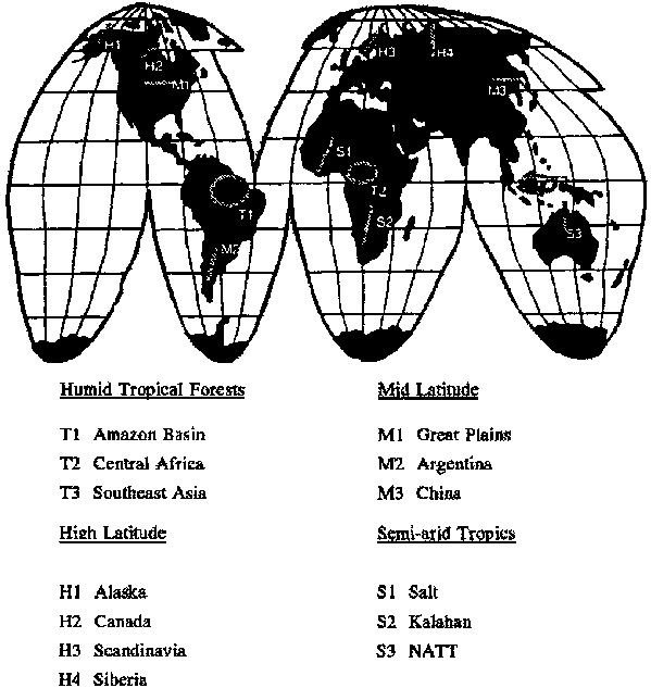
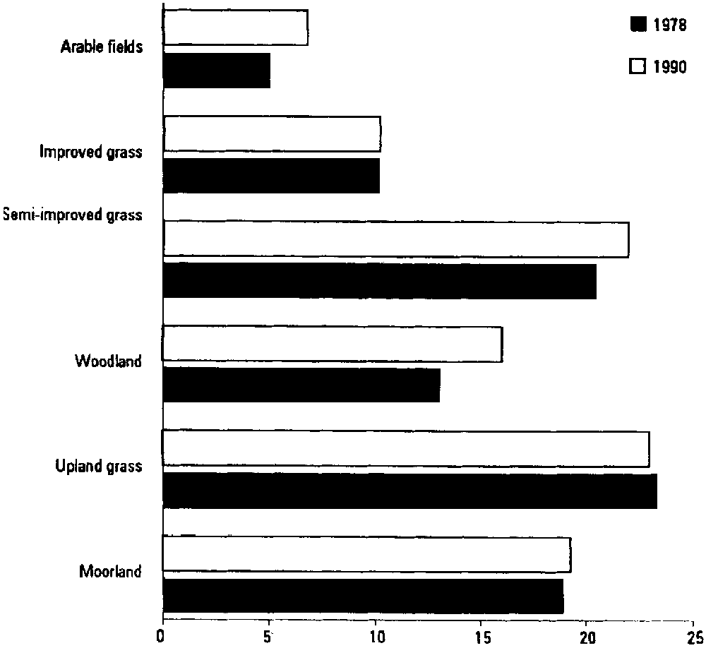