![]()
![]()
![]()
This chapter is broken into two parts. These are: (1) cryosphere observations required to understand the impact of climate change on the cryosphere and feedbacks to climate; and (2) cryosphere observations required for GCMs. These are not meant to be mutually exclusive and the reader will notice many variables are repeated in both sections. These two sections lead to the selection of a minimum set of variables that are to be included in the IOS. The reader is referred to Annex I for details on each variable, including a rationale, and the required temporal and spatial resolutions.
The cryosphere includes components such as snow cover that respond to daily forcing and others such as continental ice sheets that respond primarily to long-term (century or longer) effects. Here, we focus on components of the cryosphere that offer useful information in monitoring the climate system and in detecting natural trends or changes due to human activities on decadal time scales. It is recognized that sea ice is in the domain of the ocean component of GCOS, but is presented here so that a complete picture of the cryosphere can be obtained.
The cryosphere contains 80% of the world's fresh water and is very sensitive to climate change (Fitzharris, et al, 1996). Monitoring of the cryosphere is of importance for improved understanding of global climate, hydrologic systems and sea-level change, as well as for impact assessments and Earth system modelling. The complex nature of most cryospheric variables has necessitated that observations be made using a variety of methods involving surface and remote-sensing measurements and a range of sensors. Currently, efforts are underway to combine the preferred features of each method in order to obtain optimal representations of the important parameters. Hence, there is unlikely to be a unique observational solution in many areas of cryospheric monitoring. In several instances (permafrost conditions, ice sheet mass balance), there are currently no routine observations, while other measurements (snow water equivalent, sea ice thickness) are still in a research mode. In the case of surface observations of snow cover and freshwater ice thickness, major efforts are still needed to assemble and quality-check archival records. The type and quantity of data on frozen ground conditions and their location are only just beginning to be inventoried.
The IPCC reached the following major conclusions (Fitzharris, et al., 1996) regarding the cryosphere:
Many components of the cryosphere are sensitive to changes in atmospheric temperature because of their thermal proximity to melting. The extent of glaciers has often been used as an indicator of past global temperatures;
Projected warming of the climate will reduce the area and volume of the cryosphere. This reduction will have significant impacts on related ecosystems, associated people and their livelihoods;
There will be striking changes in the landscapes of many high mountain ranges and lands at northern and high latitudes. These changes may be exacerbated where they are accompanied by growing numbers of people and increased economic activity.
The requirements for monitoring cryospheric variables have recently been reviewed and documented in two workshop reports (Crane, 1993; Barry, et al., 1995). The parameters and necessary frequency of observations for snow cover, sea ice, glaciers, ice sheets and permafrost are summarized in Annex II (Tables 1 to 4). The availability of data sets for use in monitoring assessments has also been discussed in a number of papers by Barry (1985) and (1986), Barry and Armstrong (1987) and Walsh and Barry (1990).
Snow cover
The seasonal snow cover has high spatial variability as a result of the effects of land cover and terrain irregularities, and its extent and depth are variable on a daily time scale, at least in the transitional seasons and in the marginal snow areas. Nevertheless, its crucial role in albedo-temperature feedbacks as demonstrated empirically by Groisman, et al. (1994a) using the record of satellite-derived data, as well as its significance for hydrological processes, make certain snow cover characteristics of first-order importance (Annex II, Table 1). The overall extent and area covered by snow (in practice defined for some snow masking depth, due to the influence of vegetation) is a first-order variable. The weekly Northern Hemisphere maps of snow cover produced by NOAA from AVHRR data represent what may be called a "flagship" product that has been widely applied in trend studies for the period from 1972 to the present time and used to infer linkages between snow cover - hemispheric temperature anomalies and circulation patterns (Gutzler and Rosen, 1992; Karl, et al, 1993). Groisman, et al. (1994b) identify regions of high priority for monitoring based on the interannual variability of the snow cover. The application of passive microwave brightness temperature data to hemispheric and regional snow mapping was illustrated by Chang, et al. (1987, 1990) and Baumgartner and Rango (1991).
Recent efforts to assemble and evaluate long-run records of station snowfall and depth observations in North America (Groisman and Easterling, 1994; Karl, et al, 1993; Robinson, 1993), Switzerland (Fohn, 1990; Rohrer, et al, 1994), Austria (Mohnl, 1991), the Victoria Alps, Australia (Duus, 1992), the former Soviet Union (Barry, et al, 1994) and elsewhere, have demonstrated that there exists a substantial potential for using such information for monitoring purposes, provided that proper consideration be given to the application of appropriate corrections for changes in observational procedures and gauge characteristics over time (Groisman and Easterling, 1994).
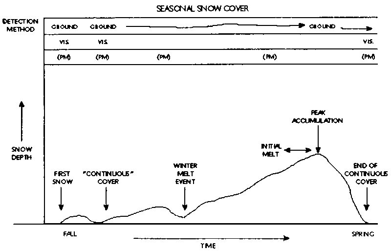
What are the most appropriate parameters of ground snow data to consider? Figure 4.1 illustrates schematically a snow pack over the course of a winter season and the capabilities of various ground and remote-sensing observations for detecting snow cover variables; airborne gamma surveys offer complementary capabilities (Carroll, 1991), and have been widely implemented in mid-western North America. The important indicators of changes in the snow conditions include: dates of the beginning and ending of a stable cover, depths, maximum snow pack water equivalent on certain fixed dates, and the duration of depths exceeding specified threshold values (Goodison and Walker, 1993). The date of snow cover disappearance has been studied on a regional scale in Arctic Alaska and Finland as a climatic indicator by Foster, 1989; and Foster, et al, 1992, but a similar approach has not yet been applied to mountainous regions for monitoring purposes. Changes in snow line elevation since the beginning of the century have been investigated in Chile (Kerr and Sugden, 1994) and elsewhere.
Sea ice
Sea ice is seasonal in both the Antarctic and Arctic shelf seas, as well as in the Hudson Bay, the Sea of Okhotsk and the Baltic Sea, and perennial in the central Arctic Ocean. Its extent and thickness reflect not only thermodynamic processes, but also the dynamic effects of forcing by the wind and ocean currents which cause drift, deformation, shear and divergence. These factors create openings (linear leads and larger irregular polynyas) in the ice as well as ridges where the motion is convergent. Hence, changes in ice extent, areal coverage and thickness, which are of special importance to climate, are a complex response to interactive atmospheric and oceanic processes.
Hemispheric ice extent in both polar regions has been reliably mapped on a weekly basis since the advent of AVHRR data in 1972 and the time series of these data are reported in Halpert, et al. (1994) for example. They show irregular fluctuations rather than any persistent trends. Maps for the Arctic, based on more limited aircraft reconnaissance, ship and coastal observations, with satellite images from the 1960s are available from 1983 and have been subsequently digitized by Walsh and Johnson (1979) from several different sources. Russian observations have existed since the 1930s for the Eurasian sector of the Arctic and these are expected to become available within 1 to 2 years.
The fractional coverage (or total concentration) of sea ice is less accurately known. Passive microwave data have been used to derive 3-day concentrations of first- and multi-year ice from the Nimbus 5 single channel Electrically Scanning Microwave Radiometer (ESMR) for 1973-76 and for 1978-87 from the Scanning Multifrequency Microwave Radiometer (SMMR) (Parkinson, et al., 1987; Gloersen, et al., 1992). The latter series has been extended by the daily mapping capability of the Special Sensor Microwave Imager (SSM/I) on the Defense Meteorological Satellite Programme (DMSP) series of satellites (Barry, 1990) (Annex 2, Figure 1). Brightness temperature data collected by the SSM/I and derived ice concentration products, both in a 25 km grid format, are distributed on compact disks by the National Snow and Ice Data Centre (NSIDC) in Boulder, Colorado, USA.
Areal extent may be determined from the weekly operational charts prepared by the US National Ice Centre (NIC). Both these weekly charts and the retrospective satellite-derived research products, available daily since 1987, represent "flagship" products that need to be supported on a continuing basis.
For the Arctic, Russian ice charts and the NIC data are now archived in format for the archival of sea-ice data in digital form (SIGRID) for the period 1967-92 in the WMO Global Digital Sea-Ice Data Bank (GDSIDB) maintained at the Arctic and Antarctic Research Institute (AARI), St. Petersburg and at the World Data Centre (WDC-A) for Glaciology/NSIDC, Boulder. The Russian data provide more detailed information on stages of ice development, although the spatial coverage is less complete than in the NIC data. The creation of a merged, optimized product is under consideration.
From a monitoring perspective, Parkinson and Cavalieri (1989), and Parkinson (1991), identify areas in both hemispheres where greater sea ice sensitivity to climatic fluctuations is to be expected. Fluctuations in hemispheric sea ice extent and ice concentrations have been analyzed for the SMMR record by Parkinson and Cavalieri (1989) and Gloersen and Campbell (1991). For the Arctic, Chapman and Walsh (1993) have studied the ice extent record from 1961. These studies suggest decadal-scale and interannual fluctuations that differ regionally in sign, but with no consistent sustained trends in either hemisphere. Strong longitudinal contrasts reflect the wave structure of the atmospheric circulation.
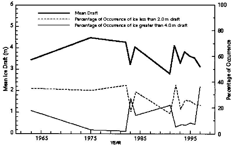
Ice thickness is an important variable in detecting climate change. Ice thickness (strictly ice draft below the sea surface) is recorded in the Arctic Ocean by upward-looking sonars (ULS), either on board submarines or at moorings. To date, few data have been released from the former, so that even the seasonal ice thickness climatology is not reliably established (Bourke and McLaren, 1992). Most ULS moorings were installed only a few years ago, but are delivering reliable and detailed point records of ice draft. In the Antarctic, thickness data have been acquired by laboriously drilling holes. Analysis of submarine measured ice draft for repeated 50 and 100 km transects at the North Pole made between 1958 and 1992 show large interannual variability with a range from 2.8 m in 1986 to 4.4 m in 1970 (McLaren, et al, 1992; McLaren, et al, 1994); the authors reported that there was no clear evidence of any trend (Figure 4.2), although Wadhams (1995) considers that the data, and his own analyses north of Greenland for 1976-87, both indicate thicker ice in the earlier years. Thus, ice monitoring needs to include information on ice motion fields from drifting buoys and satellite data.
Glaciers and ice caps
The response to climate of perennial surface ice bodies to changes in mass varies in accordance with their size over a wide range of time scales. Relatively small mountain glaciers react passively to climatic forcing and show rapid changes in geometry within decades, for example (McClung and Armstrong, 1993), whereas large ice sheets actively influence global climate and dynamically adjust to mass changes over hundreds of thousands of years (Van der Veen, 1991). Over time periods of a few decades, corresponding to the dynamic response time, cumulative length change of mountain glaciers predominantly depends on glacier size and quantitatively reflects long-term mass changes (Haeberli, 1990; Figure 4.3). The critical measurements relating to perennial surface ice bodies are summarized in Table 2 of Annex II. Length change and mass balance are primary indicators of change in mountain glaciers. Together, they constitute a key element of change detection strategies due to their pronounced climatic sensitivity and the remarkable memory, filter and enhancement functions involved with latent heat exchange, albedo and mass balance/altitude feedbacks as well as thickness/length change transfer functions.
Overall, mid- and low-latitude glaciers show widespread shrinkage in this century (Haeberli, 1995). The average mass balance of 35 annually-measured glaciers distributed over 11 mountain ranges in North America, Eurasia and Africa showed a loss of 30 cm water equivalent per annum during the decade 1980-1990. Melting of this ice thickness corresponds to an additional energy flux of some 3 watts per square metre and, hence, roughly corresponds to the estimated annual anthropogenic radiative forcing. A similar, or even a slightly accelerated rate of change was observed in the first three years of the decade 1990-2000 (International Association of Hydrological Sciences (IAHS)/International Commission on Snow and Ice (ICSI)/UNEP/UNESCO, 1994). Based on records from 48 glaciers worldwide, Oerlemans (1994) estimated a summer warming of 0.66°C since the 1880s. Meier (1984) used a selection of the 35 mass balance records to assess glacier contributions to global sea-level rise and concluded that land ice may represent about half of the total rise. It is worthwhile underlining the fact that glacier fluctuations can yield useful estimates of regional changes in integrated climatic conditions which are especially valuable in mountain areas of the world with sparse networks of conventional measurements; the latter in any case are often unrepresentative of the mountain conditions (Barry, 1993). Glacier data from central Asia are potentially of great value in this regard.
Time series of mean ice draft and frequency of ice draft less than 2.0 m and greater than 4.0 m for 50 km long segments centered over the North Pole
Figure 4.3 - Trends in the
length of 4 representative glacier types (as explained below, these are averages
for glaciers in four size categories) since 1900 showing the different responses
to climate change (from Haeberli, 1990). (A) glaciers < 2 km long; (B)
mountain glaciers 2-5 km long; (C) valley glaciers 5-10 km long; (D) valley
glaciers > 10 km long.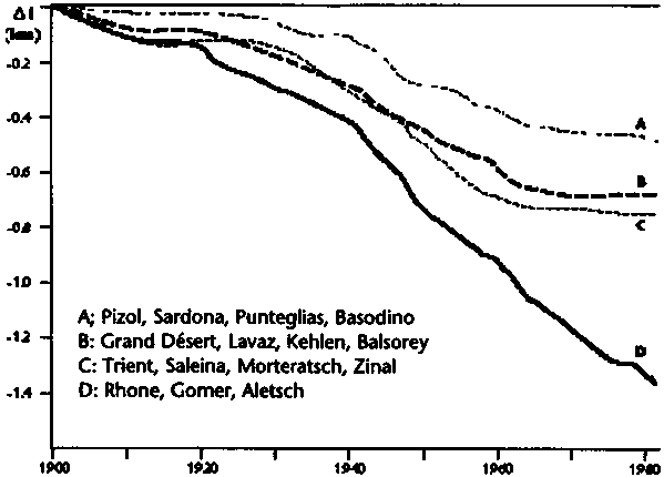
Temperature profiles in areas of cold firn at high altitudes and high latitudes (including the accumulation areas of the two large ice sheets) contain important information about decadal to secular warming trends. The temperature of the firn areas is also critical to sea level considerations in that the transition from cold to temperate firn determines whether melt water runoff in the warm season can take place in such areas or not. In connection with global warming, migration displacement of this boundary could potentially affect extended areas in mountain ranges and polar zones.
Ice sheets
In regard to the impact from the Earth's surface on the global climate system the two large ice sheets in Greenland and Antarctica are much more important than the world's glaciers and ice caps. Together they contain 80% of the Earth's fresh water. In order to understand their impact on climate and consequences of climate change, we must be able to monitor their mass balance. Unfortunately, with presently available methodology and because of a paucity of observations, even the sign of their mass balance remains in doubt. An example of the importance of monitoring their mass balance is that the exchange of water between ice sheets and the oceans, which is a function of the mass balance, remains the largest uncertainty in determining the contribution of ice sheets to sea-level rise.
The consequences of a warming climate will be very different for the two ice sheets. Warming temperatures will increase precipitation over the Antarctic Ice Sheet, but temperatures will remain too cold for significant surface ablation. However, significant increases in surface ablation will occur from the Greenland Ice Sheet. The surface ablation could increase by 50% for a 2°C warming, according to an energy balance model (Van der Waal and Oerlemans, 1994), doubling the current contribution to sea-level rise. Taken together, these effects may cancel, but the uncertainty in this estimate is equivalent to 0.5 mm/yr of sea-level change.
It is possible that atmospheric and oceanographic changes at the Antarctic Ice Sheet margins may affect the discharge of the ice sheet into the ocean. Changes at the ice sheet margins have already been observed on the Antarctic Peninsula with the collapse of the Wordie and Larsen Ice Shelves (Doake and Vaughan, 1991). There is considerable uncertainty at present as to the impact of such changes, since conditions at the bed of the ice sheet, largely insulated from the ocean and atmosphere, greatly influence the flow (MacAyeal, 1992).
As previously stated, there are large uncertainties in the present knowledge of the mass balance and the contribution of the ice sheets to eustatic sea level. Precipitation measurements have been accumulated over this century from shallow ice cores (Drewry, 1983; Ohmura and Reeh, 1991). These are irregularly distributed, with a density biased towards the more frequently visited coasts. Measurements of the calving rate, or more particularly, the flow across the point at which the ice starts to float, are sparse: less than half the outlet glaciers of Antarctica have been observed. Even in the Greenland Ice Sheet, measurements of surface ablation, from which predictions of the consequences of climate warming are made, are restricted to points on the margins and isolated traverses (Braithwaite and Olesen, 1990; Ambach, 1993).
The mass balances of the ice sheets may be determined from measuring the change in average elevation if accuracies of 5 cm/yr can be achieved. Presently, the European Remote Sensing Satellite (ERS-1) altimeter enables present measurements to be made with 10 cm/yr accuracy to 82 degrees of latitude, an accuracy that will improve to 5 cm/yr with the ERS-2 altimeter. Change measurements over longer time intervals are possible using historical observations. Zwally (1989) has estimated a 1.6 m thickening in southern Greenland by determining the different elevations over a seven-year interval from the Seasat and Geosat satellites. This measurement may be affected by orbital uncertainties (Braithwaite, 1993) which are not present in the newer satellites.
However, radar altimeter performance is significantly degraded at the steeper margins of the ice sheets, which are regions of highest mass turnover and which are most sensitive to oceanographic and atmospheric changes. Laser altimeters around the turn of the century may provide accurate change measurements at the ice sheet margins, which with modern orbit determination may achieve 3 cm/yr accuracy. An important independent constraint on ice sheet mass balance may also arise from sensitive measurements of vertical uplift and temporal variations in the gravity field (Wahr, et al, 1995).
Satellite imagery also has a very important role in determining changes in ice sheet extent. The disintegration of the Wordie and Larsen Ice Shelves, and the widespread retreat of glaciers on the Antarctic Peninsular were observed from changes in airborne, Landsat and Synthetic Aperture Radar (SAR) imagery. The geography of the interior of ice sheets is itself uncertain. Fahnestock, et al. (1993) have recently observed undiscovered large scale ice flows in northern Greenland. The recent development of interferometric techniques to determine displacement fields (Goldstein, et al, 1993) provides a method to observe in great detail dynamic flows at the ice sheet margins.
A better understanding of accumulation and ablation processes on the Greenland Ice Sheet is essential to secure predictions of its mass balance. Although ablation rate cannot be measured by satellite, the mapping of the melt zones is possible with passive microwave data and SAR data. Mote, et al. (1993) show from SSM/I data that the extent of summer ablation in Greenland varied widely during summers 1987-89. The combined SSMR and SSM/I record will permit an extended assessment of any trends. To date, surface accumulation has not been successfully measured by satellite, although passive microwave measurements are sensitive to accumulation rates.
Freshwater ice
The freeze-up and break-up of lakes and rivers are closely correlated with air temperatures in the transition seasons. Analysis of lake records in North America and Eurasia has shown that the dates of ice cover formation and disintegration each vary about 4-7 days/degree C change in mean air temperature during the corresponding seasons (Skinner, 1993). There is a better and more robust correlation in the autumn than in the spring when snow cover on the ice, discharge from small streams and wind effects modulate the basic energy exchange processes. The timing of freeze-up and break-up of ice may be used as an indicator of air temperature trends.
Lakes selected for monitoring should preferably be of a similar size, covering an area of a few hundred square kilometres, and relatively shallow. An extensive surface introduces the effects of wind fetch; large lakes are also unsuitable as only a small area may be visible from shore, and they are often deeper, with greater heat storage. Barry and Maslanik (1994) suggest that satellite monitoring could greatly augment the number of lakes that can be studied; they show that although cloud obstruction may be more frequent in the autumn, there is quite close agreement between ground and satellite estimates of freeze-up dates. There are surface records spanning 25 to 45 years for some 250 lakes in Canada (Skinner, 1988) and much longer ones for lakes and rivers in Scandinavia (Kuusisto, 1993) and the former Soviet Union.
Permafrost
Permanently frozen ground underlies some 25% of the Earth's land surface. It is widespread in Canada and Alaska, northern Russia and parts of north-east China, but it also occurs in many mid-latitude high mountains and on the Tibetan Plateau (Barry, 1985). Permafrost is believed to form gradually over very long time intervals (105 years), occurring continuously where mean annual air temperature is <-7°C. Along the margins, where it is thin and discontinuous, permafrost degradation can be monitored. Changes in the permafrost and the overlying summer active layer can have important effects on hydrological regimes, ecological and geomorphological conditions, and structures (Koster and Nieuwenhuijzen, 1992; Nelson, et al., 1994). In areas of thick continuous permafrost, changes are detectable in profiles of ground temperature measured in deep boreholes. Lachenbruch and Marshall (1986), for example, reported 2 to 4°C warming in the upper 100 to 150 m of boreholes in Arctic Alaska, which they related to a temperature rise over the last 100 years or so. However, changes in ground temperature reflect a complex response to surface temperature and moisture conditions, vegetation cover, winter snow depth and any disturbances due to fire, plant succession, or human activity. Moreover, the air temperature record at Barrow does not suggest a sustained warming. Increased recognition is being given to the active layer data for monitoring and model validation. Gilichinsky (1986) provides illustrations of the seasonal course of active layer temperature and snow depth at three sites in the steppe and steppe-woodland zones of western Siberia over a ten-year period. However, there are currently no generally available data sets for research use. Planning for appropriate databases for purposes of monitoring, model validation and development, and applications is being actively pursued by the Data and Information Working Group of the International Permafrost Association (IPA) (Barry and Brennan, 1993). In several mountain areas, a ground temperature monitoring programme has been initiated (Haeberli, et al, 1993) and initial results indicate a recent rapid rise in ground temperature at various sites in central Asia and the European Alps.
The impact of the cryosphere on global climate change is further emphasized by the sensitivity of GCMs to fluctuations in large ice sheets (Clark, et al, 1995). Topography and albedo of the then existing ice sheets explain most of the cooling of the Northern Hemisphere during the latest ice age (Manabe and Broccoli, 1985). Many well known ice sheet/atmospheric interactions are common results of several independent GCMs. Better use of existing glacier inventory and permafrost distribution data could help in validating GCMs, particularly where poor weather records exist.
However, there are several issues of impact on climate of large ice sheets that still need to be explored, and hence a need for an expanded observing system. A basic requirement for modelling the influence of ice sheets on climate is improved data on distribution of temperature, precipitation and runoff on the surface of the ice sheet. Clark, et al. (1995) also emphasized the need for a database of three-dimensional ice-sheet geometry to be developed for the large ice sheets of the globe. If more detailed information on ice sheet dimensions, insolation and atmospheric composition can be obtained to study interannual variability, coupling of ice sheet models to GCMs will be a useful tool to solve the existing problems in understanding the mass balance of large ice sheets.
Another important issue which may be studied by GCMs is the inter hemispheric communication between ice sheets in the Northern and Southern Hemispheres which takes place through the general circulation of the atmosphere and the oceans. Such studies may call for coupled ocean-atmosphere GCMs, which treat heat transport linked to thermohaline circulation that originates in the North Atlantic.
Also relevant to the above issue and mentioned by Clarke, et al. (1995) is the need to understand the causes of the episodic discharge of icebergs from the Greenland Ice Sheet which at present are unknown. These discharges of icebergs may have a crucial effect on climate of the Northern Hemisphere through controlling the salt content of the thermohaline circulation in the North Atlantic.
Table 4.1 summarizes the minimum set of cryospheric variables that are required to detect climate change, assess the impacts of climate change, predict seasonal to interannual climate and to simulate long-term climate changes.
Table 4.1 - Key variables for cryospheric observations.
|
Sea ice concentration/extent Sea ice motion Sea ice thickness Snow cover area Snow depth Snow water equivalent Ice sheet mass balance Ice sheet geometry Glaciers and ice caps Lake and river freeze-up and break-up (timing) Permafrost - active layer Permafrost - thermal state |
![]()
![]()
![]()